Hokkaido Location Map: Where Is Hokkaido on Japan Map?
Hokkaido sits at the very top of Japan — literally the country's northernmost main island — floating above Honshu and connected by the Seikan Tunnel under the sea.
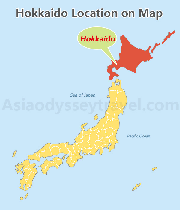
On a Japan map, it's easy to spot: big, green, and shaped a bit like a rough diamond, with plenty of coastline.
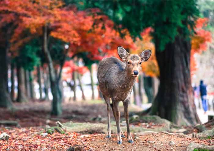
This island is a world apart from Japan's crowded cities — think vast national parks, powdery snow, fresh seafood that practically melts in your mouth, and landscapes that change wildly with the seasons.
Hokkaido Map with Cities & Towns
Hokkaido is wild but gentle. It's dotted with cities that each have their own flavor.
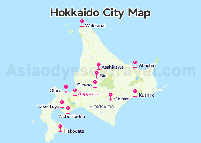
Look at the Hokkaido city map to clear the location of these popular cities and towns.
Sapporo - The lively capital of Hokkaido, famous for beer, ramen, and the annual Snow Festival.
Asahikawa - Central hub with a foodie scene and the famous Asahiyama Zoo.
Hakodate - Southern port city known for its night view and historic Western-style buildings.
Otaru - Canal-side charm and music box nostalgia, an easy day trip from Sapporo.
Furano - World-famous for its vast, rolling lavender fields that bloom from July to August.
Biei - Known for its "Patchwork Road" and "Panorama Road," offering stunning vistas of rolling hills and the mystical Blue Pond (Aoiike).
Noboribetsu - Japan's most famous hot spring (onsen) resort town with the spectacular Jigokudani ("Hell Valley").
Lake Toya - A scenic town centered around a large, picturesque caldera lake with an active volcano nearby.
Obihiro - Surrounded by Tokachi's farmland, known for butadon (pork rice bowls) and desserts.
Kushiro - Gateway to Kushiro Wetlands and fresh seafood, especially robatayaki.
Abashiri - Known for drift ice in winter and the Okhotsk Sea coast.
Wakkanai - Japan's northernmost city, launching point for Rishiri and Rebun islands.
Tip: While Sapporo is the main arrival point for most travelers, you can fly directly into several of these cities to save travel time within Hokkaido.
Hokkaido Tourist Map: Attractions by Region with Ski Resorts & Onsen
Hokkaido's main tourist areas are concentrated in the island's southwestern and central regions. Based on popularity among travelers, Asia Odyssey Travel has divided Hokkaido into four major tourist regions.
Look at the Hokkaido Attractions Map. Let's break it down into four popular areas:
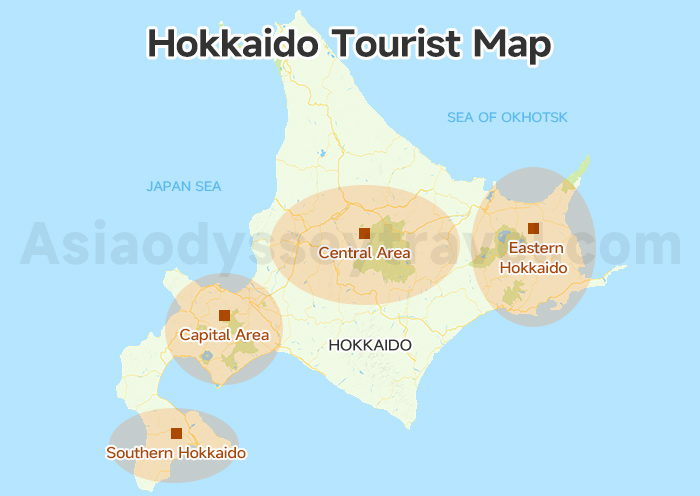
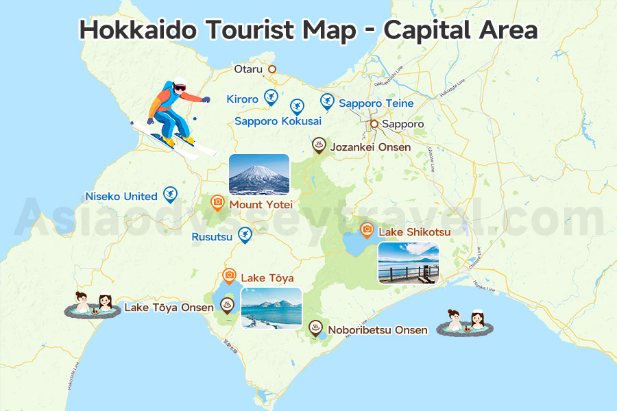
1. Capital Area: Gateway, Urban Charm with Ski Resorts & Onsen
This is the vibrant heart of Hokkaido and the primary entry point for most visitors. The area is home to the prefectural capital and its most popular cities, Sapporo and Otaru, along with world-class natural landscapes, ski resorts, and hot spring towns.
Sapporo is famous for its Snow Festival, summer matsuri, and landmarks like Odori Park and Sapporo TV Tower.
Otaru, just 40 km from Sapporo, charms visitors with its Otaru Canal, nostalgic streets, and romantic winter scenery.
Nature lovers will find some of Hokkaido's most iconic landscapes here:
- Mount Yotei - A perfectly shaped volcano often called the “Mt. Fuji of Hokkaido.”
- Lake Tōya & Lake Shikotsu - To the south and southeast of Mt. Yotei lie these two stunning caldera lakes, which are part of the Shikotsu-Toya National Park.
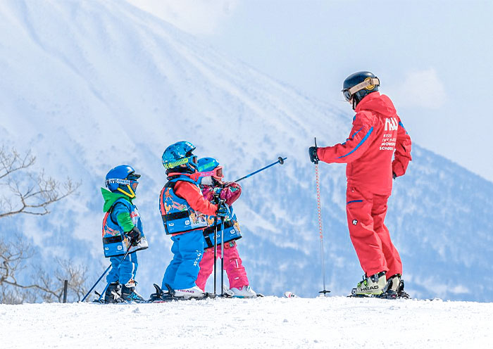
If you're into winter sports, the Sapporo Area has some of Hokkaido's top ski resorts: Niseko United, Sapporo Kokusai, Kiroro, Rusutsu, and Sapporo Teine.
For a relaxing soak, the area also offers famous onsen towns: Noboribetsu Onsen, Jozankei Onsen, and Lake Tōya Onsen.
Plus, New Chitose Airport, Hokkaido's main international gateway, is located right here, making it the perfect starting point for your trip.
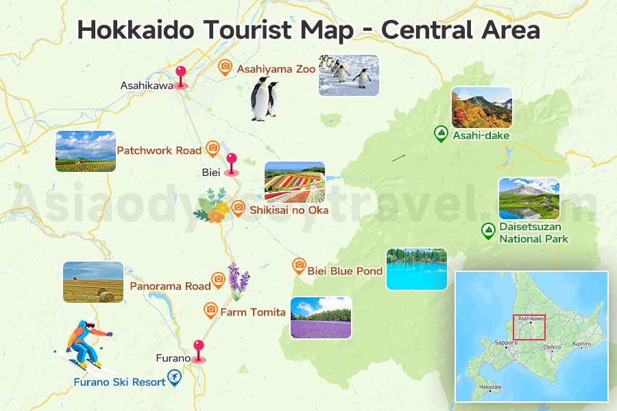
2. Central area - Flower Fields & Mountain Air
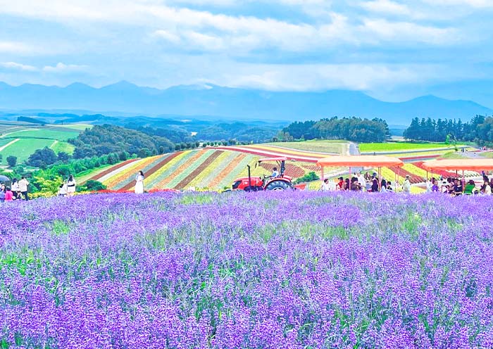
Central Hokkaido shines all year round, but Furano and Biei steal the spotlight in summer. Rolling hills, endless flower fields, and wide-open skies create one of the most romantic rural landscapes in Japan.
Furano & Biei Summer Highlights
- Farm Tomita - Japan's most iconic lavender fields, blooming in July, plus colorful flower gardens and lavender ice cream.
- Shikisai no Oka - Rolling hills carpeted with seasonal blooms from spring through autumn, with tractor rides for a leisurely view.
- Biei Blue Pond - A mesmerizing turquoise pond surrounded by slender white birch trees, stunning year-round.
- Patchwork Road & Panorama Road - Scenic drives past vast farmland, famous lone trees, and endless sky.
In winter, Furano Ski Resort turn to a world-class powder snow with runs for all skill levels and sweeping mountain views.
Beyond the countryside, you'll find Asahikawa, Hokkaido's second-largest city. It's famous for its penguin parade in winter and innovative, close-up animal viewing experiences year-round in Asahiyama Zoo.
Don't miss the nearby Asahi-dake and Daisetsuzan National Park too. Asahi-dake is Hokkaido's highest peak and Daisetsuzan National Park offers alpine hiking in summer and powder snow adventures in winter.
3. Southern Hokkaido - History, Harbors & Mountain Views
Southern Hokkaido blends a touch of old-world charm with some of the island's most iconic views. It's also the Shinkansen gateway to Hokkaido, since Hakodate is the northernmost point Japan's bullet train can reach. It's packed with history, seafood, and stunning scenery.
Highlights in southern Hokkaido:
Hakodate Morning Market - Wake up to fresh uni, squid, and crab, or grab a seafood rice bowl for breakfast.
Mount Hakodate Night View - A sparkling panorama of the city and bay, ranked among Japan's top three night views.
Motomachi - A hillside neighborhood filled with Western-style churches and historic buildings from the port's trading days.
Goryokaku - A star-shaped fort turned park, magical during cherry blossom season.
Onuma Quasi-National Park - Just north of Hakodate, this lake-and-island landscape is perfect for walking, cycling, or canoeing with Mount Komagatake as the backdrop.
Hot Springs - Unwind in onsen towns like Yunokawa Onsen, famous for its beachfront baths (and even an onsen for monkeys).
Matsumae Castle - Japan's northernmost castle, surrounded by over 10,000 cherry trees that turn the grounds pink in spring.
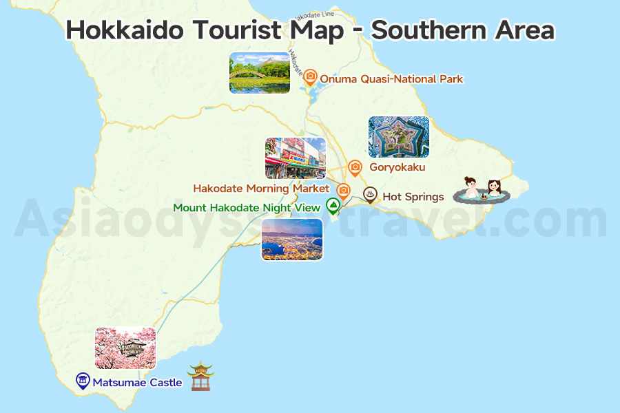
Southern Hokkaido is the perfect place to slow down, savor fresh seafood, enjoy sweeping views, and discover a gentler pace of life—whether under blooming cherry trees or in the quiet snowfall of winter.
4. Eastern Hokkaido - Wild Nature & Untamed Landscapes
Eastern Hokkaido delivers raw beauty and wide-open horizons you can't find anywhere else in Japan. Here, you can cruise past drifting sea ice, watch brown bears from the safety of a boat, and stand on cliffs where the land truly feels like the edge of Japan.
Every season brings something special—frozen seas in winter, flower-filled meadows in summer, and golden marshes in autumn.
Here's what you can get in Eastern Hokkaido:
Shiretoko Peninsula - A UNESCO World Heritage site and one of Japan's last true wilderness areas. Spot brown bears, go on coastal cruises, or hike to hidden waterfalls.
Akan-Mashu National Park - Famous for mystical Lake Mashu (one of the clearest lakes in the world), Lake Akan with its rare marimo algae balls, and steaming volcanic landscapes.
Kushiro Shitsugen Wetlands - Japan's largest marshland, best explored by train, canoe, or boardwalk, and home to the graceful red-crowned crane.
Abashiri - See drift ice in winter aboard an icebreaker cruise, and learn about the region's history at the Abashiri Prison Museum.
Kawayu Onsen - A sulfur-scented hot spring town perfect after exploring nearby volcanic craters.
Nemuro & Cape Nosappu - Japan's easternmost point, where you can watch the sunrise before anyone else in the country.
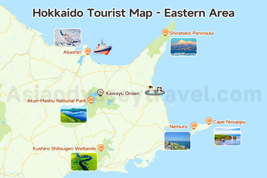
Eastern Hokkaido is for those who love the outdoors at its purest—vast skies, untouched landscapes, and wildlife encounters you'll remember for a lifetime.
Hokkaido Railway Map - Ride the Rails Across the North
Traveling Hokkaido by train is part of the wild adventure. JR Hokkaido's network connects cities, hot spring towns, ski resorts, and remote coasts, while the Hokkaido Shinkansen links the island directly to Japan's main island, Honshu.
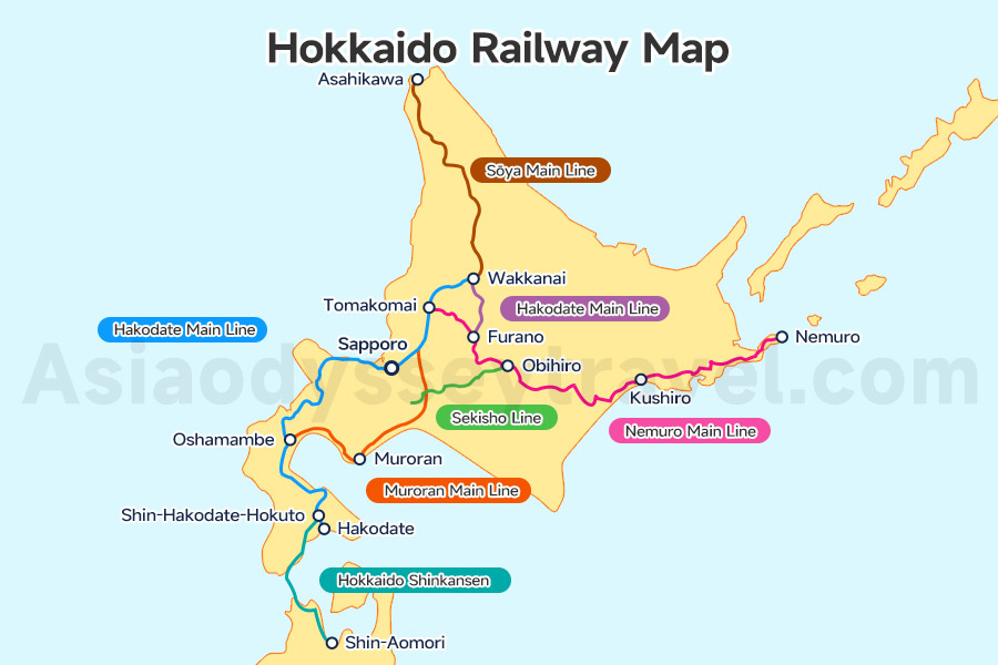
Hokkaido Shinkansen Map - Bullet Train Gateway
Route: Runs from Shin-Aomori (Honshu) through the Seikan Tunnel to Shin-Hakodate-Hokuto, the southern gateway to Hokkaido.
Travel Time: About 4 hours from Tokyo; faster routes are expected when the line extends to Sapporo in the future (planned completion 2030).
Hokkaido JR Train Map - Main JR Routes
Hakodate Main Line - Connects Hakodate ↔ Sapporo ↔ Asahikawa. Your go-to route for hitting major cities and Otaru.
Muroran Main Line - Links Oshamambe ↔ Muroran ↔ Tomakomai, ideal for accessing Lake Tōya, Noboribetsu Onsen, and ferry ports.
Sekisho & Nemuro Main Lines - Take you from Sapporo ↔ Obihiro ↔ Kushiro, perfect for reaching Eastern Hokkaido's wetlands and national parks.
Sōya Main Line - Runs Asahikawa ↔ Wakkanai, the northernmost railway in Japan, with access to Rishiri and Rebun islands.
Furano Line - Connects Asahikawa ↔ Furano, a scenic summer ride through flower fields and farmland.
Rail Pass Tip: For longer trips, the JR Hokkaido Rail Pass gives unlimited travel for 3-7 days, making it a great deal if you plan to crisscross the island.
Hokkaido Airport Map - Fly In and Out with Ease
Hokkaido is a large island, so flying is often the fastest way to get between distant regions. Several airports connect Hokkaido's cities with the rest of Japan—and in some cases, with overseas destinations.
New Chitose Airport (CTS), near Sapporo, is the main gateway to Hokkaido. It offers frequent connections to Tokyo, Osaka, Nagoya, and some international cities like Seoul, Shanghai and Beijing.
You can also fly into Hakodate Airport (HKD) or Asahikawa Airport (AKJ) from Japan's popular tourist cities like Tokyo, Osaka or Nagoya.
Other domestic airports for reaching more remote areas include:
Memanbetsu Airport (MMB) - Gateway to Eastern Hokkaido and the Shiretoko Peninsula.
Kushiro Airport (KUH) - Ideal for visiting Kushiro Wetlands and Akan National Park.
Wakkanai Airport (WKJ) - The northernmost airport in Japan, close to Rishiri and Rebun islands.
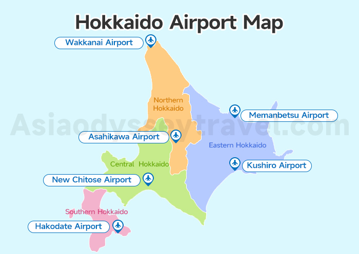
Check the Hokkaido airport map to see the best entry point for your trip.
Hokkaido Travel Map: Travel around Hokkaido with Map
Hokkaido is much larger than most visitors expect. Driving or taking the train between cities can take several hours, so it's good to plan ahead. The table below shows approximate distances and average travel times between popular destinations by both train and car.
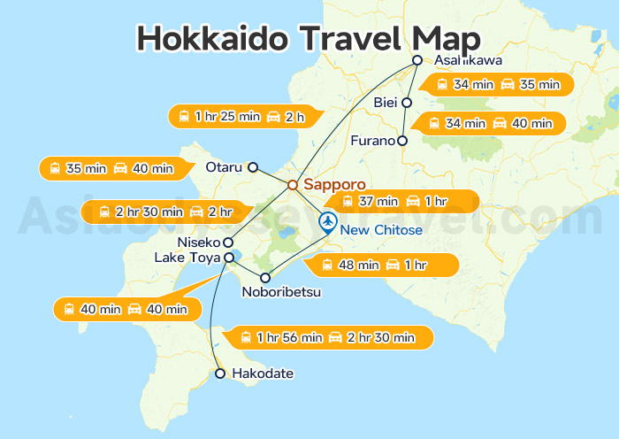
The Hokkaido travel map shows the routes and times in an easy-to-read diagram.
| From → To | Distance (km) | By Public Trans (Train or Bus) | By Car |
|---|---|---|---|
| Sapporo → Otaru | 37 km | 35 min (Hakodate Line) | 40 min |
| Sapporo → Asahikawa | 140 km | 1 hr 25 min (Hakodate Line) | 2 hr |
| Asahikawa → Biei | 25 km | 34 min (Furano Line) | 35 min |
| Biei → Furano | 34 km | 34 min (Furano Line) | 40 min |
| Sapporo → New Chitose | 52 km | 37 min (Rapid Airport) | 1 hr |
| New Chitose → Noboribetsu | 85 km | 48 min (Suzuran) | 1 hr |
| Noboribetsu → Lake Toya | 45 km | 40 min (Muroran & Hokuto) | 40 min |
| Lake Toya → Hakodate | 150 km | 1 hr 56 min (Hokuto) | 2 hr 30 min |
| Sapporo → Niseko | 110 km | 2 hr 30 min (JR via Otaru) | 2 hr |
Tip: Train times are based on JR services (including limited express or shinkansen where available). Car times are based on expressway driving and may be longer in winter.
Hokkaido Tour Map with Distance
Hokkaido's charm changes completely with the seasons. Here are two sample routes—one for summer flower season in central Hokkaido, and one for winter snow season around Sapporo.
1. Summer Route - Sapporo & Central Hokkaido (7-8 days)
Best for: Flower fields, mountain scenery, and relaxing hot springs.
Route: Sapporo → Asahikawa → Biei → Furano → Noboribetsu → Lake Toya → Otaru → Sapporo
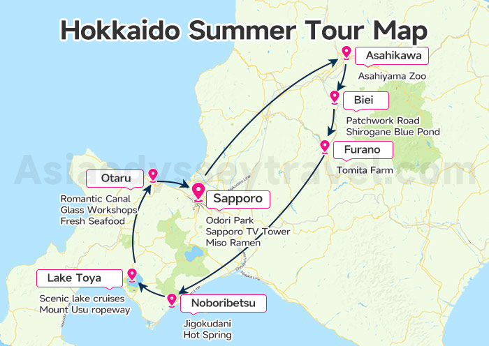
Highlights you can get:
Sapporo: Odori Park, Sapporo TV Tower, and local food like miso ramen.
Asahikawa: Asahiyama Zoo with its penguin parade (winter) or summer wildlife shows.
Biei: Patchwork Road and Shirogane Blue Pond.
Furano: Tomita Farm lavender fields (July) and rolling countryside.
Noboribetsu: Jigokudani (Hell Valley) and hot spring baths.
Lake Toya: Scenic lake cruises and Mount Usu ropeway.
Otaru: Romantic canal, glass workshops, and fresh seafood.
2. Winter Route - Sapporo & Surrounding Areas (6-7 days)
Best for: Snow festivals, hot springs, and skiing.
Route: Sapporo → Otaru → Lake Toya → Noboribetsu → Ski Resort (e.g., Niseko, Rusutsu, or Kiroro) → Sapporo
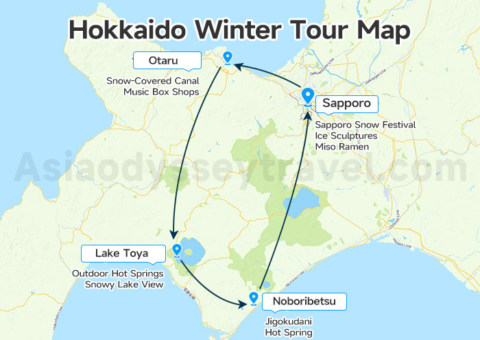
Highlights you can get:
Sapporo: Sapporo Snow Festival (Feb), ice sculptures, and warm miso ramen.
Otaru: Snow-covered canal views and music box shops.
Lake Toya: Outdoor hot springs with snowy lake views.
Noboribetsu: Steaming Hell Valley and relaxing onsen.
Ski Resort: Powder snow, snowboarding, and après-ski hot springs.
Explore Hokkaido & Japan with Asia Odyssey Travel
Planning just a quick day trip? Or want to dive deeper into Japan's most exciting cities? Wherever you're headed - Tokyo, Yokohama, Kyoto, Osaka, Mount Fuji, or beyond - we've got the routes, rides, and guides to make it smooth and memorable.
At Asia Odyssey Travel, we offer:
✅ Affordable Japan group tours
✅ Tailored private tours: Tokyo Tours, Kyoto Tours, Osaka Tours, Mount Fuji Tours, and more
✅ Comfortable intercity transfers with expert local guides and experienced drivers
✅ Updated toursit maps for different destinations: Tokyo map, Kyoto map, Hokkaido map, and more
✅ Various itineraries designed for different seasons
✅ Ultimate Travel Guide: Japan travel guide, Japan tourist map, and transportation guide between cities.
We'll make sure your Japan journey is effortless, exciting, and exactly how you imagined it.


")
: Travel & Sightseeing Map | 2026")
")

")

")
 Map: Tourist, Sightseeing & Metro Map of Nagoya")
")
: Tourist & Sightseeing Map | 2026")


")
")