Sapporo Location Map - Where is Sapporo on Japan Map
Where is Sapporo? Well, to find it on a Japan map, you need to check the northern part of the country. Sapporo is the capital city of Hokkaido, Japan's northernmost main island.
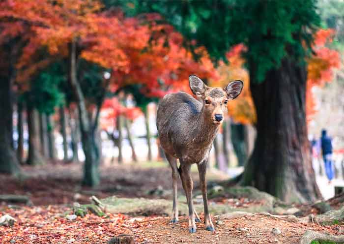
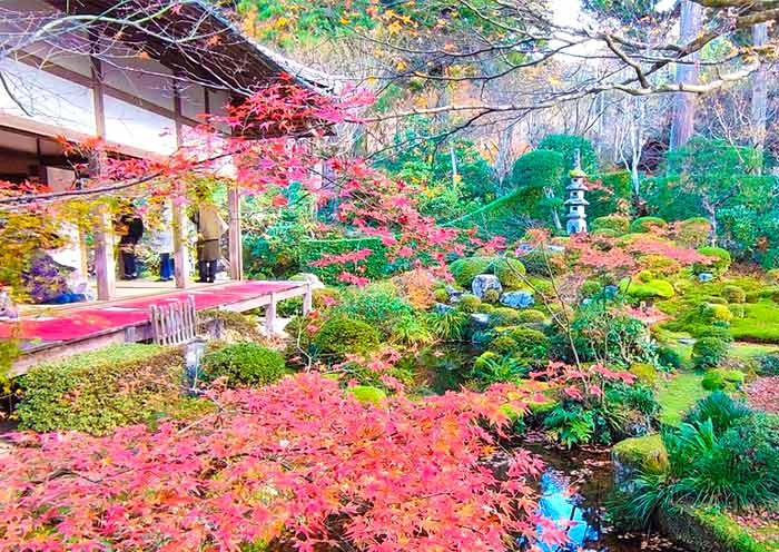
It's famous for its snowy winters, fresh seafood, beer culture, and wide streets lined with seasonal flowers.
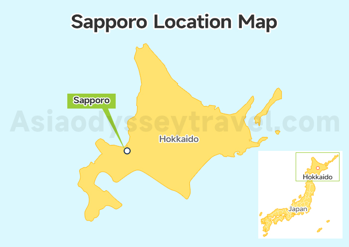
On the map, you'll find it in the southwestern part of Hokkaido, about 830 km north of Tokyo.
Sapporo Attractions Map
Sapporo's charm is easy to discover thanks to its neat city layout and well-connected transport. We've split the main sightseeing spots into three easy zones — so you can plan your day (or days) without the hassle.
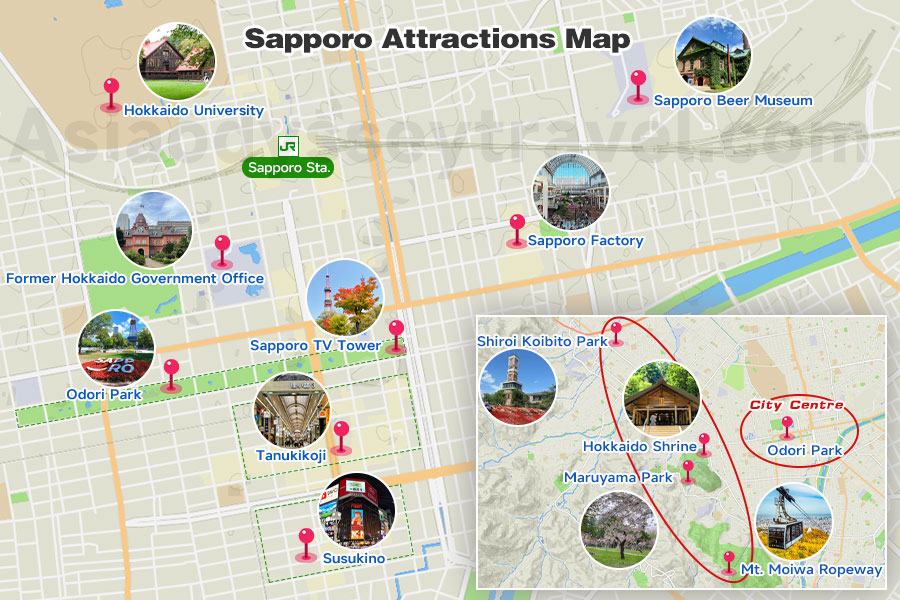
City Center & Around - The Heart of Sapporo
This is where most travelers begin. The downtown core is walkable, with shopping, dining, and iconic landmarks all within easy reach.
Odori Park – The city's green (or snowy white) spine, stretching 1.5 km across downtown. In February, it turns into the Sapporo Snow Festival's main stage.
Sapporo TV Tower – For sweeping city views from the top.
Susukino – The neon-lit entertainment district, famous for ramen alleys and nightlife.
Former Hokkaido Government Office – Brick beauty from the 19th century, right in the middle of modern Sapporo.
Tanukikoji Shopping Street - Covered arcade with shops, souvenirs, and street food.
Slightly away from downtown, you'll find unique museums, green spaces, and modern art.
Hokkaido University – Stroll through leafy campus avenues.
Sapporo Beer Museum & Beer Garden – Learn about Hokkaido's brewing history and taste fresh draft beer.
Sapporo Factory – Shopping and dining in a renovated beer brewery.
Maruyama & West Sapporo – Nature & Culture
Just a short subway ride from downtown, this area combines peaceful parks, shrines, and mountain views.
Maruyama Park – A top cherry blossom spot in spring.
Hokkaido Shrine – Surrounded by forest, especially lovely during cherry blossom season.
Mt. Moiwa Ropeway – Night views so romantic it's called a "lover's sanctuary."
Shiroi Koibito Park - A chocolate lover's dream! Explore the whimsical factory and gardens where Sapporo's famous Shiroi Koibito cookies are made.
Otaru – A Day Trip by the Sea
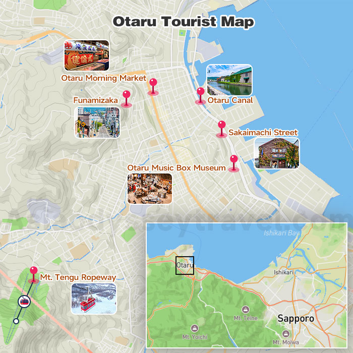
Got a little extra time? Take a short train ride to Otaru, a charming port town known for its nostalgic canal, glass art, and fresh seafood.
Otaru Canal – The postcard-perfect spot, especially pretty at night when the old warehouses are lit up.
Sakaimachi Street – Lined with glass workshops, music box stores, and dessert shops (try the cheesecake at LeTAO!).
Otaru Music Box Museum – More magical than it sounds, with hundreds of tinkling music boxes on display.
Mt. Tengu Ropeway – Ride up for panoramic views of Otaru and the bay, especially magical at sunset or with winter lights.
Otaru Morning Market (Otaru Sankaku Market) – Feast on fresh sushi, crab, scallops, and uni, served right at tiny counter restaurants.
Funamizaka (Ship-Viewing Slope) – A charming hillside street where the view down to the port looks like a ship sailing straight toward you.
Sapporo City Map: Station & Airport
Sapporo Station Map
Sapporo Station is the city's main gateway, where JR trains, subways, buses, and taxis all come together. It's a lively hub with shopping malls, restaurants, and even a hotel or two — perfect for starting or ending your day.
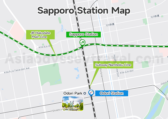
From here, you can catch:
JR Hakodate Main Line — Connects Sapporo to Otaru, New Chitose Airport, and beyond.
Subway Namboku Line & Tozai Line — Fast access to downtown and other neighborhoods.
Airport Limousine Bus — Direct rides to New Chitose Airport, handy if you're flying in or out.
Sapporo Airport Map
Most travelers flying into Sapporo will land at New Chitose Airport (CTS), about 45 km southeast of the city. It's a mini theme park with shopping streets, a Doraemon-themed zone, and even an onsen.
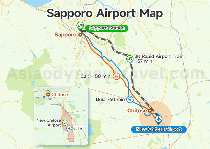
Travel time to Sapporo:
By JR Rapid Airport Train: ~37 minutes to Sapporo Station.
By Bus: ~60 minutes to Sapporo Station(depends on traffic).
By Car: ~ 50 minutes to central Sapporo (depends on traffic)
Pro tip: If you arrive in winter, check the map for indoor routes between terminals and transport — it's warm, dry, and snow-free!
Sapporo Subway Map: Travel around the City
Sapporo's subway system is small but mighty — just three lines (Namboku, Tozai, and Toho), all meeting at Odori Station in the city center. This makes it almost impossible to get lost, even if you're new to the city.
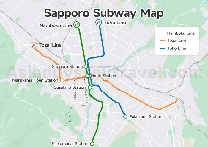
Namboku Line (Green) – Runs north–south, linking Sapporo Station, Odori, Susukino, and Makomanai (near ski areas).
Tozai Line (Orange) – Runs east–west, connecting Maruyama Park, and Shiroi Koibito Park (via bus).
Toho Line (Blue) – The quieter line, perfect for getting to Sapporo Dome.
Pro tip: Subway stations are well-heated in winter, so you can use them to escape the cold while sightseeing.
Sapporo Travel Map with KM
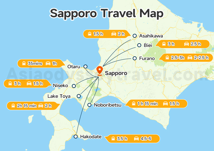
Once you've explored Sapporo's snow sculptures, ramen alleys, and nightlife, it's time to see the rest of Hokkaido. The Sapporo travel map shows how Sapporo connects to some of Hokkaido's most famous destinations — whether you're chasing ski slopes, flower fields, or hot springs.
| Destination | Distance from Sapporo | By Train (from Sapporo Station) | By Car/Bus | Highlights |
|---|---|---|---|---|
| Otaru | ~40 km | JR Hakodate Main Line, ~35 min | ~1 hr | Canal, seafood, glassware, music boxes |
| Asahikawa | ~140 km | JR Ltd. Exp. Kamui/Lilac, ~1.5 hr | ~2 hr | Asahiyama Zoo, winter snow festival |
| Furano | ~110 km | Via Asahikawa, ~2.5–3 hr | ~2–2.5 hr | Lavender fields (summer), skiing (winter) |
| Biei | ~140 km | Via Asahikawa, ~3 hr | ~2.5 hr | Blue Pond, rolling hills |
| Hakodate | ~310 km | Hokkaido Shinkansen, ~3.5 hr | ~4.5–5 hr | Night view, morning market, historic port |
| Lake Toya | ~110 km | JR Ltd. Exp. Hokuto, ~2 hr + bus | ~2 hr | Lakeside resorts, fireworks, volcano views |
| Noboribetsu | ~110 km | JR Ltd. Exp. Hokuto, ~1 hr 15 min + bus | ~1.5 hr | Jigokudani (Hell Valley), hot springs |
| Niseko | ~100 km | JR Hakodate Line via Otaru, ~3 hr | ~2–2.5 hr | Ski slopes, powder snow, après-ski scene |
Sapporo Tour Map: Plan Your Summer & Winter Adventures with Map
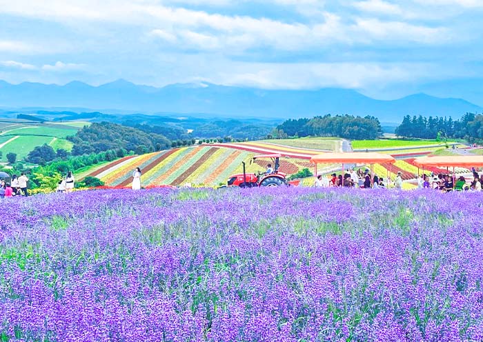
Sapporo Summer Tour Map - Ride to Furano & Biei
Bask in Hokkaido's summer charm with a scenic journey from Sapporo to Furano and Biei, where rolling flower fields, Panorama Road, and Patchwork Road burst into vivid color.
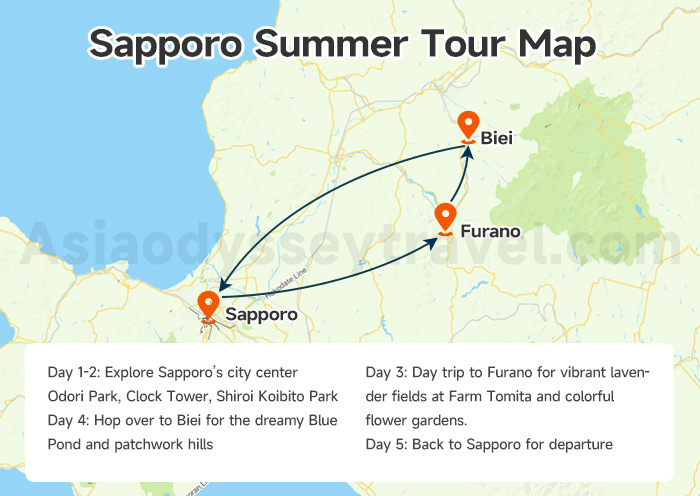
This route offers easy self-drive or guided day trip options, with plenty of stops for lavender ice cream and panoramic photo spots.
Day 1-2: Explore Sapporo's city center – Odori Park, Clock Tower, Shiroi Koibito Park.
Day 3: Day trip to Furano for vibrant lavender fields at Farm Tomita and colorful flower gardens.
Day 4: Hop over to Biei for the dreamy Blue Pond and patchwork hills.
Day 5: Back to Sapporo for departure
Tip: Use the JR Furano-Biei Norokko train (seasonal) for scenic rides through the countryside.
Sapporo Winter Tour Map - Enjoy Snow Fun
Turn Sapporo into your snowy playground! From ski slopes at Sapporo Teine to snow festivals, and from hot spring escapes to a day trip to Otaru's frosty canal, winter here blends festive charm with pure powder fun.
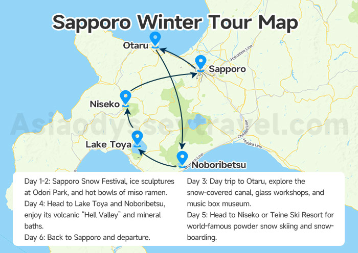
Day 1-2: Sapporo Snow Festival, ice sculptures at Odori Park, and hot bowls of miso ramen.
Day 3: Day trip to Otaru, explore the snow-covered canal, glass workshops, and music box museum.
Day 4: Head to Lake Toya and Noboribetsu, enjoy its volcanic “Hell Valley” and mineral baths.
Day 5: Head to Niseko or Teine Ski Resort for world-famous powder snow skiing and snowboarding.
Day 6: Back to Sapporo and departure.
Tip: Book ski buses or JR train passes in advance for smooth travel during peak season.
Explore Sapporo & Japan with Asia Odyssey Travel
Planning just a quick day trip? Or want to dive deeper into Japan's most exciting cities? Wherever you're headed - Tokyo, Yokohama, Kyoto, Osaka, Mount Fuji, or beyond - we've got the routes, rides, and guides to make it smooth and memorable.
At Asia Odyssey Travel, we offer:
✅ Affordable Japan group tours
✅ Tailored private tours: Tokyo Tours, Kyoto Tours, Osaka Tours, Mount Fuji Tours, and more
✅ Comfortable intercity transfers with expert local guides and experienced drivers
✅ Updated toursit maps for different destinations: Tokyo map, Kyoto map, Hokkaido map, and more
✅ Various itineraries designed for different seasons
✅ Ultimate Travel Guide: Japan travel guide, Japan tourist map, and transportation guide between cities.
We'll make sure your Japan journey is effortless, exciting, and exactly how you imagined it.


")


")
")
")
")
: Travel & Sightseeing Map | 2026")
")
: Tourist & Sightseeing Map | 2026")
")
 Map: Tourist, Sightseeing & Metro Map of Nagoya")