Nara Japan Map – Where is Nara Located in Japan
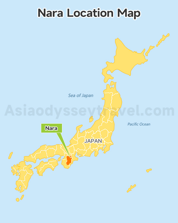
Look at this Nara location map and you'll instantly get why Nara is perfect for your Japan trip. It sits right in the heart of the Kansai region, the central part of Japan. It just 45 minutes from both Osaka and Kyoto. That's like traveling from Manhattan to Brooklyn.
It forms a golden triangle with Osaka and Kyoto. Most travelers stay in Osaka (for the food and nightlife) or Kyoto (for temples and tradition), then take easy day trips to Nara.
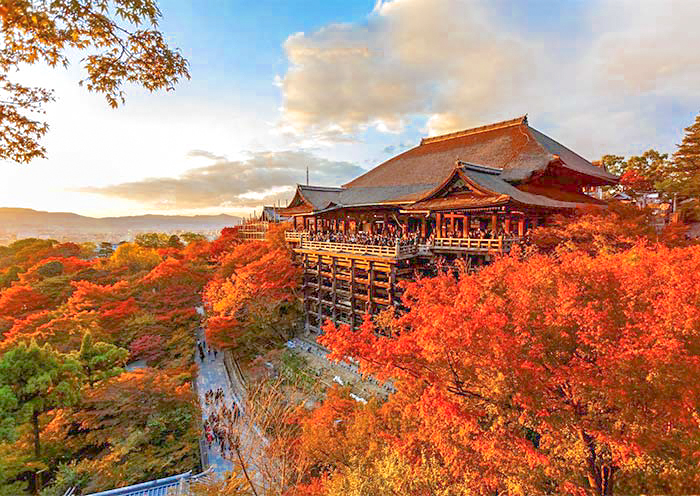
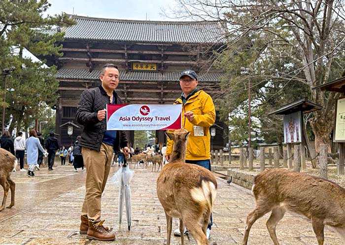
Nara is famous for one thing above all - over 1,200 wild deer that bow to you for crackers. But here's what most tourists miss: this small city was Japan's first permanent capital (710-794 AD), even before Kyoto.
That's why you'll find some of Japan's oldest and largest temples here, including Todaiji with its massive Buddha.
Nara City Map: City Center & Layout
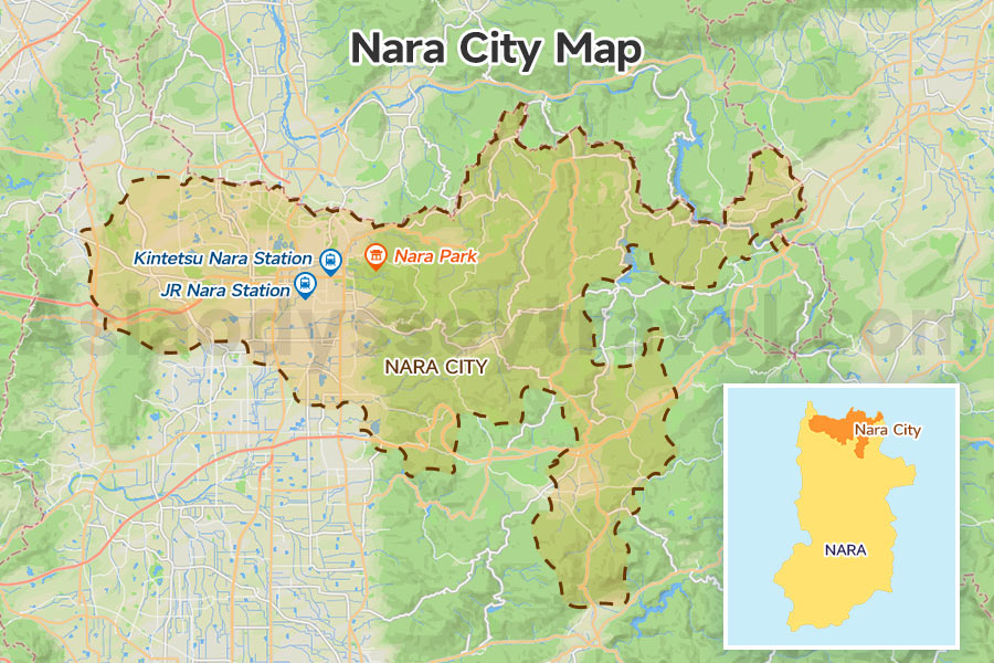
Nara City itself is quite large, covering about 277 square kilometers. To give you an idea, the main tourist area of Nara feels similar in size to a famous historic city like Florence, Italy, where you can easily walk between all the major sights.
Our Nara City map clear shows the city center: area round Kintetsu Station. Your explore revolves around two train stations and one massive park. JR Nara Station on the west, Kintetsu Nara Station in the middle, and Nara Park stretching east.
Kintetsu Station is 500 meters closer to the deer park than JR Station. That's a 5-minute walk versus 15 minutes. The main shopping arcade, Higashimuki Street, connects Kintetsu Station directly to the park entrance.
Between the two stations runs Sanjo Street - the main commercial strip where locals actually shop and eat.
The eastern half of the city is basically one giant park (Nara Park) that blends into temple grounds. There's no clear boundary - you'll just notice more deer and fewer buildings as you head east. Most tourists never venture beyond the park area.
Nara Park Map: Where to Find Deer, Todaiji & Top Temples
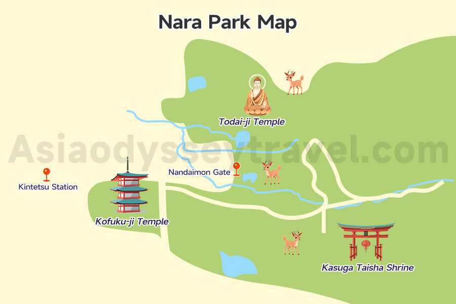
Here's something we've learned at Asia Odyssey Travel: For more than 80% of our guests, when they say they're going to "Nara," they really just mean they are going to Nara Park to feed the deer. The park is the main event. Everything else is just a bonus.
The Park is HUGE
The deer own Nara Park - they've been considered sacred messengers of the gods for over 1,000 years.
And Nara Park is a giant nature park with 660 hectares (1,630 acres), temples, shrines, and forests included. That's bigger than Central Park in New York. All the main things you want to see are in the western part.
Where to Find the Deer
This whole area is deer territory. They are everywhere! But if you want to find the biggest groups of deer, they usually hang out in three main spots:
- At the park entrance (They know tourists with food arrive here).
- Around Todai-ji Temple (They wait for the big tour groups).
- Near anyone selling deer crackers (The little stalls are everywhere).
What to See in the Park - Famous Spots Located
Todai-ji Temple (The Big Buddha): It anchors the park's north section. This is the most famous temple. It's a 20-minute walk from Kintetsu Station. Inside is a giant 15-meter (50-foot) tall Buddha statue.
Kofuku-ji Temple (The Tall Pagoda): South of Todaiji, you'll find Kofukuji Temple with its iconic five-story pagoda - perfect for photos.
Kasuga Taisha Shrine (The Lantern Shrine): Further south lies Kasuga Taisha Shrine, famous for its 3,000 stone lanterns. The path between these temples is where you'll encounter the most deer and best photo opportunities.
Nara Tourist Map: Map of Nara Attractions & Sightseeing Locations
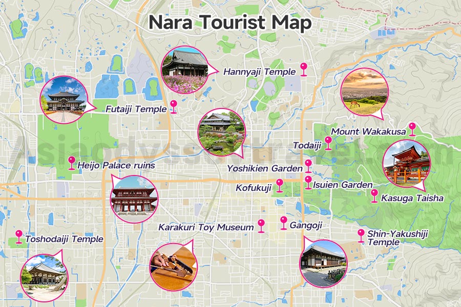
we've covered the park where all the deer action happens. But Nara has way more to offer if you know where to look. The full Nara attraction map reveals hidden gems that most day-trippers totally miss.
Everything tourists want sits in a concentrated area. From Kintetsu Station to the farthest temple is about 2.5 km - that's a 35-minute walk max.
Cultural Treasures - Besides the Big Three (Todaiji, Kasuga Taisha, Kofukuji)
You've got Nara National Museum for Buddhist art, Gangoji Temple (UNESCO site with Japan's oldest roof tiles), and Toshodaiji Temple where Chinese monk Jianzhen taught Buddhism. Don't miss Shin-Yakushiji Temple with its circle of fierce guardian statues.
Hidden Neighborhoods
Naramachi district south of Kofukuji - old merchant houses now hosting sake breweries, traditional craft shops, and the quirky Karakuri Toy Museum. North of the park, explore Kidera area for local life and great restaurants.
Nature Escapes
Mount Wakakusa for sunset views (closed Dec-March), Isuien Garden's two-part design, peaceful Yoshikien Garden (free for foreign tourists!), and the Primeval Forest behind Kasuga Shrine - a UNESCO site where no tree has been cut for 1,000 years. Find Your Zen in Japanese Gardens >>
Off-the-Beaten-Path
Heijo Palace ruins (free entry, huge grounds), Futaiji Temple on Mount Nijo for hiking, and Hannyaji Temple famous for cosmos flowers.
Top 7 Things to do in Do in Nara: Places to Visit & Nara Tourist Attractions
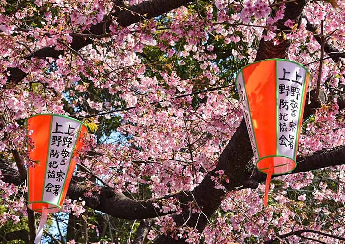
Nara Cherry Blossom Map
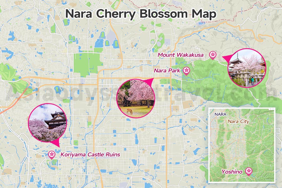
If you're lucky enough to visit Nara during sakura season (late March to early April), you're in for something magical. Picture this: ancient temples, bowing deer, AND pink cherry blossoms all in one frame.
Our Nara cherry blossom map shows you exactly where to catch this triple threat.
When Cherry Blossoms Bloom in Nara
Nara's cherries typically bloom a few days after Kyoto and Osaka - usually around March 28 to April 5. But here's the secret: Nara's elevation differences mean blossoms last longer. When park cherries fade, mountain areas are just starting.
Prime Blossom Spots Our Map Reveals:
Nara Park: Over 1,700 cherry trees scattered throughout. The deer grazing under pink petals? That's your money shot. Best spots: around Ukimido Pavilion on Sagiike Pond, and the hillside near Kasuga Taisha.
Mount Wakakusa: The slopes turn pink while offering city views. Climb for 30 minutes and you'll have cherry blossoms in the foreground, Todaiji in the background.
Koriyama Castle Ruins: Just 15 minutes from Nara by train, this spot has 1,000 cherry trees and way fewer tourists. Local secret - they light them up at night during peak bloom.
Yoshino (OK, it's an hour away, but worth it): Japan's most famous cherry blossom spot with 30,000 trees. Four different areas bloom at different times, extending the season to almost a month.
Nara Fall Foliage Map
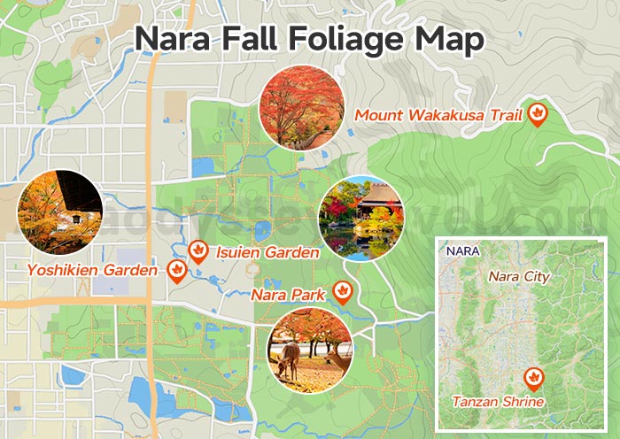
Nara in autumn (mid-November to early December) serves up the same fiery reds and golden yellows, but with deer wandering through the fallen leaves. Our Nara fall foliage map pinpoints where nature puts on its best show.
Nara's autumn arrives fashionably late - usually peaking around November 20-30. The mountains turn first, then the parks, giving you three solid weeks of color.
Top Foliage Spots the Map Highlights:
Nara Park: Sure, the main park has maples. But follow our map to Mizuya Shrine and the paths behind Kasuga Taisha. Red maples frame stone lanterns while deer munch on fallen leaves. Pure Japan.
Isuien & Yoshikien Gardens: These neighboring gardens were literally designed for autumn viewing. Isuien's borrowed scenery technique makes distant mountains part of the garden. Yoshikien? Free for foreign visitors and never crowded.
Tanzan Shrine: 45 minutes south of Nara, this mountain shrine explodes with 3,000 maple trees. The 13-story pagoda surrounded by red leaves looks straight out of a postcard. Locals come here, tourists don't know about it.
Mount Wakakusa Trail: The autumn version hits different. Golden grasses on the summit, red maples on the slopes, and views of the entire colored valley below. Check More Japan Autumn Tour Packages to Catch Most of Fall Colors in Japan >>
Nara Walking Map: Self-Guided Routes
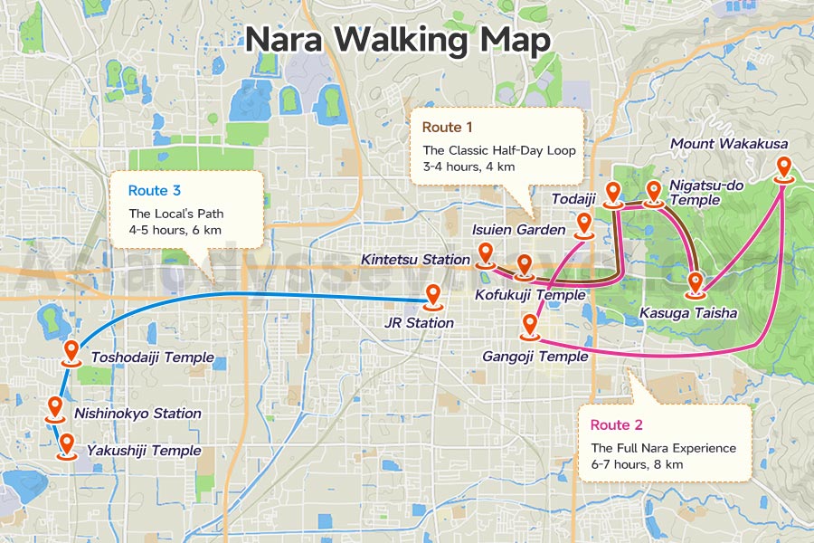
Nara is a walking city, plain and simple. Our walking map gives you three tested routes that hit everything worth seeing, plus timing that actually works in real life.
Route 1: The Classic Half-Day Loop (3-4 hours, 4 km)
Start at Kintetsu Station → Higashimuki Shopping Street (grab coffee) → Kofukuji Temple → Through Nara Park to Todaiji → Loop back via Nigatsu-do Temple → End at Kasuga Taisha. This hits all the Instagram spots plus maximum deer encounters. Perfect for first-timers or anyone short on time.
Route 2: The Full Nara Experience (6-7 hours, 8 km)
Everything from Route 1, PLUS: Climb Mount Wakakusa (add 1 hour), explore Naramachi old town for lunch, visit Gangoji Temple, and finish at Isuien Garden. This is what we recommend if you've got a full day. Pace yourself - there's a lot of walking uphill.
Route 3: The Local's Path (4-5 hours, 6 km)
Skip the crowds entirely. Start at JR Station → Walk through real neighborhoods to Toshodaiji Temple → Nishinokyo area → Yakushiji Temple → Train back from Nishinokyo Station. You'll see magnificent temples minus the selfie sticks.
Nara Travel Map: Transportation Hubs, Accommodation Area & Dining
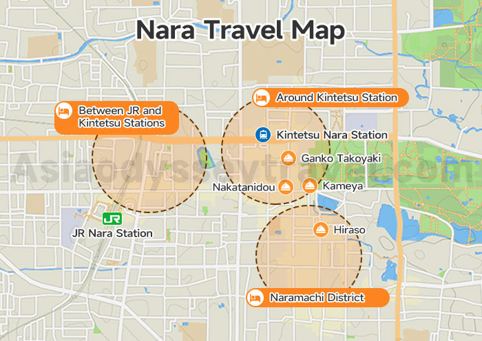
Time for the practical stuff - where to sleep, how to get around, and (most importantly) where to eat. Our Nara travel map breaks down Nara's logistics so you can focus on enjoying the deer and temples.
Transportation Hubs
Two stations run the show. Kintetsu Nara Station wins for tourists - it's 500 meters closer to the deer park and connects directly to Kyoto (35 min) and Osaka Namba (40 min). JR Nara Station works if you have a JR Pass, but it's a longer walk to everything.
Where to Stay - Best Accommodation Areas
Around Kintetsu Station: Prime real estate for tourists. Hotels here put you 5 minutes from the deer park and surrounded by restaurants. Downside? Prices reflect the convenience.
Between JR and Kintetsu Stations: The sweet spot for budget travelers. Slightly longer walk to attractions but more hotel options and local restaurants. This area feels less touristy at night.
Naramachi District: Want atmosphere? Stay in a renovated merchant house turned boutique hotel. You're near local bars and cafes, though farther from the stations.
Top Dining Picks Locals Actually Recommend
Kameya (near Sarusawa Pond): Their kakinoha-zushi (persimmon leaf sushi) is Nara's signature dish done right. Expect lines at lunch.
Hiraso (Naramachi): Old-school spot for kaki-no-ha sushi where they still wrap each piece by hand. Cash only, closes early.
Nakatanidou (Sanjodori): The mochi shop where they pound rice at high speed. Pure theater plus the freshest mochi you'll ever eat.
Ganko Takoyaki (Higashimuki Street): Yes, takoyaki is Osaka's thing, but this place rivals the best there. Perfect snack while exploring.
Kamakura Pasta (near Kintetsu): When you're sick of Japanese food, this Italian-Japanese fusion hits the spot. Great lunch sets.
Edogawa (near Kintetsu): Splurge-worthy unagi (grilled eel) in a traditional setting. Reservation recommended for dinner. Taste Your Way Through Japan >>
Nara Loop Bus Map: When Your Feet Need a Break
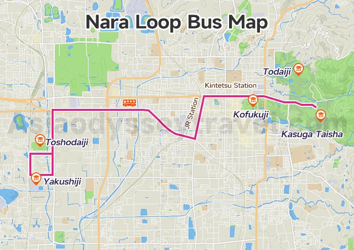
Look, we've been telling you Nara is walkable, and it is. But after 20,000 steps, those deer start looking less cute and more like obstacles. Enter the Nara Loop Bus - your feet's best friend when temples feel too far apart.
Two routes circle the main tourist sites. The red route hits Nara Park attractions (Todaiji, Kasuga Taisha, Kofukuji). The blue route ventures to western temples (Toshodaiji, Yakushiji).
Both start from JR and Kintetsu stations. Buses run every 15-20 minutes from 9 AM to 5 PM.
Osaka Kyoto Nara Map: Kansai Triangle Map
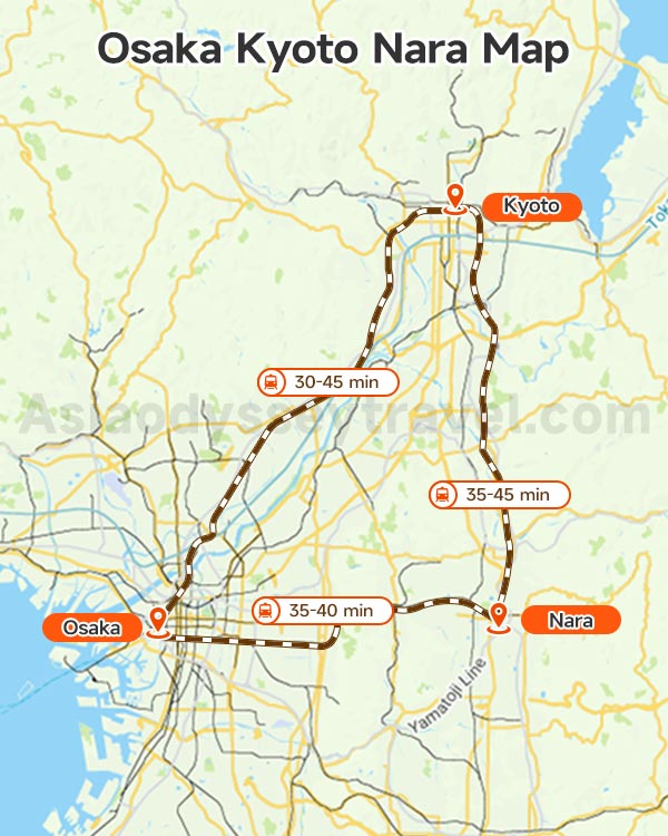
Welcome to Kansai's golden triangle: Osaka, Kyoto and Nara. Our Kansai Triangle map shows you how Osaka, Kyoto, and Nara connect like puzzle pieces.
Osaka sits on the western point, right on the coast. Kyoto takes the northern point, tucked against the mountains. Nara claims the southeastern corner, the smallest but oldest of the three.
The whole triangle fits in an area about 50 km across - that's smaller than most major metropolitan areas.
Osaka is your foodie playground and nightlife hub. Kyoto brings the postcard temples and geisha districts. Nara? That's your chill day with deer and fewer crowds. Each city is 30-45 minutes from the others.
You could literally have breakfast in Osaka, lunch in Nara, and dinner in Kyoto.
- Osaka to Kyoto: 50 km north (30-45 min by train)
- Osaka to Nara: 35 km east (35-40 min)
- Kyoto to Nara: 45 km south (35-45 min)
Osaka to Nara: Kintetsu Nara Line from Namba (40 min, ¥680) or JR Yamatoji Line from Osaka Station (50 min, ¥1,040). Kintetsu wins - it drops you closer to the deer.
Kyoto to Nara: Kintetsu Limited Express (35 min, ¥1,280) or JR Nara Line (45 min, ¥720). Both work fine, pick based on your starting point in Kyoto.
Osaka to Kyoto: This isn't even fair - you have like six options. Fastest? JR Special Rapid (30 min, ¥570). Cheapest? Keihan Main Line (45 min, ¥420).
How to Get to Nara from Osaka | Osaka to Nara Train & Bus
How to Get to Nara from Kyoto 2026
Osaka Kyoto Nara Itinerary 3-7 Days: Best Kansai Itinerary Ideas
Discover Kanazawa & Japan with Your Local Guide - Asia Odyssey Travel
Explore Japan with Asia Odyssey Travel! We are a local travel company with an office in Tokyo. We are here to help you enjoy the best of Japan. We offer simple, fun, and real local tours.
Our Japan Tours at a Glance:
✅ Japan Tours: 60+ Best Tour Packages
✅ Japan Group Tours: 6+ great value trips, including cherry blossoms & classical routes.
✅ Nara Tours: Feed the friendly deer and see the Great Buddha.
Helpful Guides for Your Japan Trip:
Japan Travel Guide & Travel FAQs: All you need to know before you go.
Useful Advice for Nara: Maps · Things to Do in Nara
Contact us now and start planning your dream Japan tour.


")


")
")
")
: Travel & Sightseeing Map | 2026")
")
: Tourist & Sightseeing Map | 2026")
")
 Map: Tourist, Sightseeing & Metro Map of Nagoya")