Yokohama Location Map: Where is Yokohama on Map?
If Tokyo is Japan's buzzing capital, then Yokohama is its chill, seaside cousin—cool, relaxed, and just a stone's throw away. Located less than 30 km south of Tokyo (about 30–40 minutes by train), Yokohama sits right on Tokyo Bay, making it Japan's second-largest city and one of the best day-trip destinations from the capital.
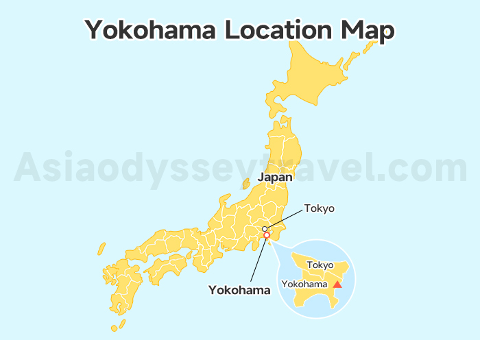
Check out the map, and you'll see it's perfectly sandwiched between Tokyo and the ocean—close to the action but with its own unique vibe.
Yokohama Tourist Attractions Map: What to See & Where They Are
Yokohama is one of the most popular day-trip options from Tokyo. It is a breeze to explore and packed with eye-catching spots, especially around its beautiful waterfront. To help you make the most of your time, we've grouped the best attractions into two main areas you'll find clearly marked on the following Yokohama tourist map:
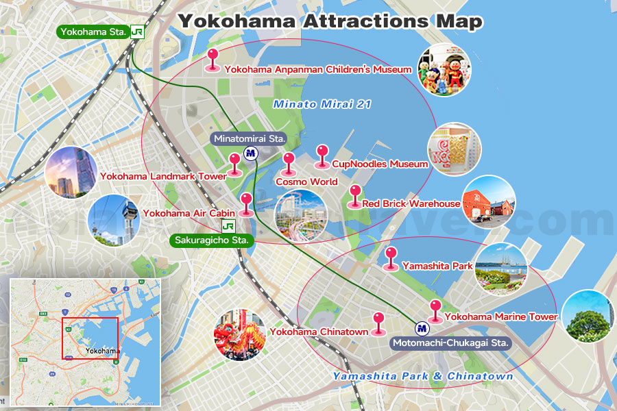
Minato Mirai 21 – The Waterfront Wonder
Map Location: Central coast of Yokohama
Best For: Families, couples, city views, shopping, museums
This is the heart of modern Yokohama. With futuristic towers, scenic bay views, and family-friendly attractions all clustered along the harbor, Minato Mirai is the place where most visitors start (and often stay for the whole day!). It's stylish, scenic, and super walkable.
Top sights here:
- Yokohama Anpanman Children's Museum: A colorful, cheerful space that little ones absolutely adore.
- Yokohama Landmark Tower: Head up to the 69th floor for stunning views of the city and even Mount Fuji on clear days.
- Yokohama Air Cabin: Japan's first urban ropeway. Glide over the city from Sakuragicho to the waterfront in style.
- Cosmo World: That massive Ferris wheel? That's here! A compact amusement park with rides for all ages.
- CupNoodles Museum: Yep, it's where you can learn (and make!) your own instant noodles.
- Red Brick Warehouse: Historic buildings turned into trendy shops and cafes. Great for photos!
Tip: Everything is within walking distance here. Just hop off at Minatomirai Station (Minatomirai Line) or Sakuragicho Station (JR).
Yamashita Park & Chinatown – Classic Yokohama Stroll
Map Location: East of Minato Mirai, along the coast
Best For: Walks by the sea, Chinese food, history buffs
This area offers a more old-school Yokohama vibe. On your tourist map, it's just a 10–15 min walk or short subway hop from Minato Mirai.
Don't miss:
- Yamashita Park: Seaside park with views of ships and the iconic Hikawa Maru ocean liner.
- Yokohama Chinatown: Japan's largest! Get lost in the lantern-lined alleys and try everything from steamed buns to Peking duck.
- Yokohama Marine Tower: For panoramic harbor views from the top.
Nearest Station: Motomachi-Chukagai Station (Minatomirai Line)
Yokohama City Map: Stations & Cruise Terminal
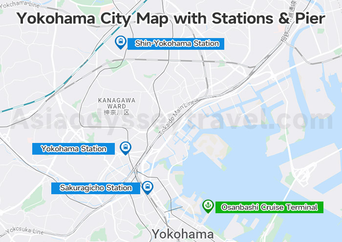
Yokohama is compact and easy to explore, with a few key stations worth knowing:
Yokohama Station – The main city hub, served by JR, Tokyu, Keikyu, Sotetsu, and Yokohama subway lines. Great for shopping and quick transfers.
Shin-Yokohama Station – This is where the Shinkansen (Tokaido Line) stops. Perfect if you're coming from Kyoto, Osaka, or Nagoya by bullet train. From here, hop on the Blue Line subway to reach Minato Mirai or Yokohama Station in 10–15 minutes.
Sakuragicho & Kannai Stations – Closer to the waterfront, these JR/subway stops are ideal for visiting Minato Mirai, Yamashita Park, and Chinatown.
Osanbashi Cruise Terminal – If you're arriving by cruise, this modern terminal is right by the bay, walking distance to major sightseeing spots like Red Brick Warehouse and Yamashita Park.
Tip: If you're arriving by Shinkansen, Shin-Yokohama is your gateway. If you're already in Tokyo, it's faster to head to Yokohama Station or Sakuragicho directly via JR or private lines.
Yokohama Subway / Metro Map: Navigating the City
Yokohama's subway system is smooth, convenient, and easy to master—especially for travelers. It has 3 key subway/metro lines:
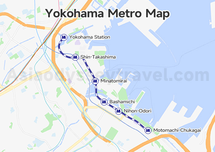
Minatomirai Line – the most important for tourists! It links Yokohama Station with top attractions like Minato Mirai, Bashamichi, Nihon-odori, and Motomachi-Chukagai (near Chinatown).
Blue Line – runs northeast to southwest, connecting key spots like Yokohama Station, Sakuragicho, and Kannai.
Green Line – serves the northern suburbs. Not typically used by short-term tourists, but helpful if you're staying further out.
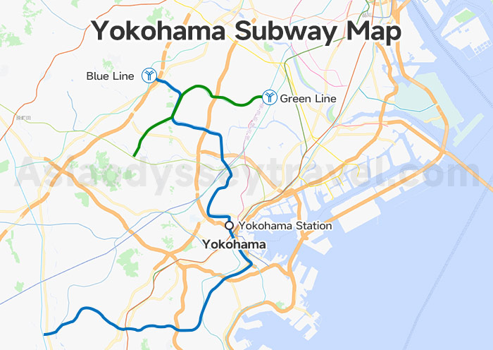
Transfer Tips: Subway ↔ JR Lines
Yokohama Station is the big hub where you can easily switch between JR and subway lines.
Sakuragicho Station is a super handy transfer point between the JR Negishi Line and the Blue Line, right next to the Minato Mirai area.
Shin-Takashima Station (Minatomirai Line) and Yokohama Station are connected underground—look for signs!
Pro Tip:
If you're visiting all the big spots—Chinatown, Red Brick Warehouse, Cup Noodles Museum, and the waterfront—it's the Minatomirai Line you'll ride the most. It's practically made for tourists.
Yokohama Travel Map: How to Get to & Around Yokohama
Yokohama Tokyo Map: How to Get to Yokohama from Tokyo
Yokohama is only about 30 kilometers from Tokyo, and the easiest way to travel between the two cities is by train.
You might think the Shinkansen is the fastest choice—but surprise! It's actually not the best option here. The Shinkansen connects Tokyo Station and Shin-Yokohama Station, which is about 9 km from central Yokohama. Meanwhile, regular JR lines like the Tokaido Line, Shonan-Shinjuku Line, and Keihin-Tohoku Line can take you directly to Yokohama Station, located right in the city center—just 1 km from Minato Mirai 21, Yokohama's main sightseeing hub.
Not only are JR trains more convenient, they're also much cheaper than the Shinkansen.
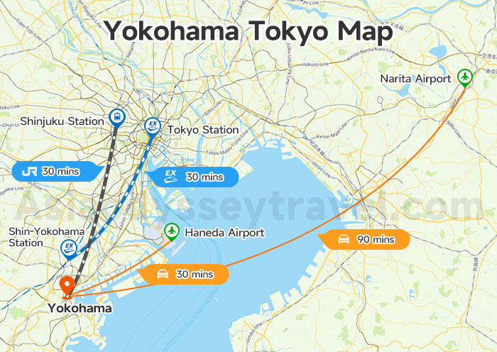
Check the map to see the best connections and travel times from popular spots around Tokyo:
- From Tokyo Station: About 30 mins via JR Tokaido Line or Keihin-Tohoku Line
- From Shinjuku: About 35–40 mins via JR Shonan-Shinjuku Line
- From Haneda Airport: Around 30 mins by train or airport limousine bus
- From Narita Airport: Around 90 mins – it's farther, but still doable for international travelers
If you're already in Tokyo, you can easily hop on a JR train and start exploring Yokohama in under an hour.
Yokohama to Kamakura Map
Kamakura is just a short ride from Yokohama and makes for a perfect day trip filled with temples, beaches, and giant Buddhas. The map below shows the simple route connecting Yokohama and Kamakura.
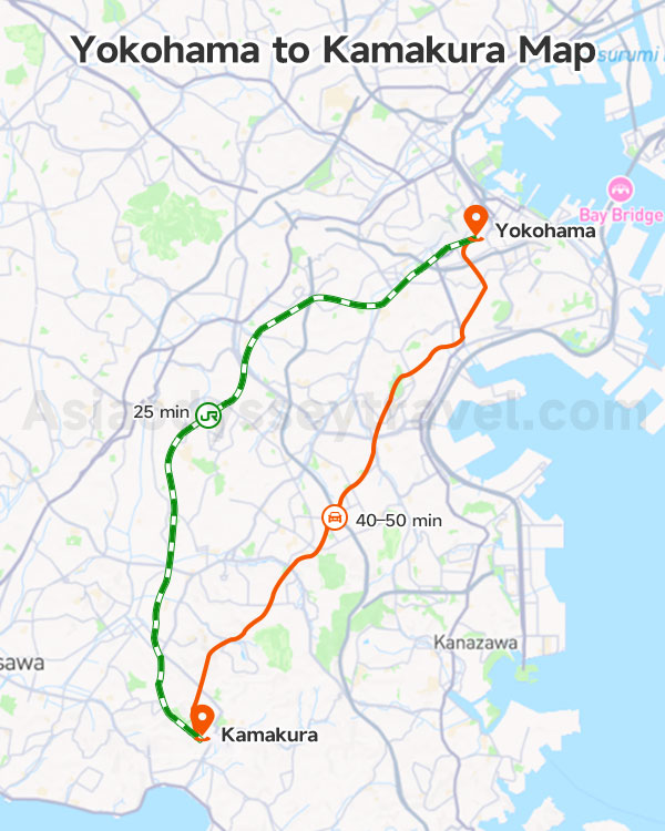
By JR Line (Most Direct):
Take the JR Yokosuka Line directly from Yokohama Station to Kamakura Station – about 25 minutes, no transfers.
By car:
Driving from Yokohama to Kamakura takes around 40–50 minutes. It's a scenic and flexible option, especially if you plan to visit nearby beaches or temples spread out across the Kamakura area.
Tip: Kamakura's main sights like Tsurugaoka Hachimangu, Hasedera, and the Great Buddha (Daibutsu) are easily accessible from Kamakura Station or Hase Station.
Yokohama Hotels Map: Where to Stay
Not sure where to stay in Yokohama? Here's a simple breakdown of the three best hotel areas — each offering its own vibe, convenience, and views. Whether you're after family comfort, budget basics, or luxury with a view, there's a spot for you.
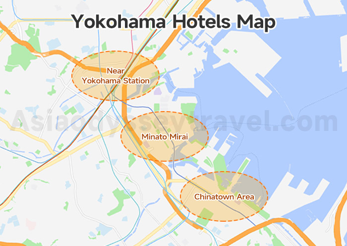
- Near Yokohama Station – Most Convenient for Travel
This is Yokohama's main transport hub, with direct trains to Tokyo, Kamakura, and Haneda Airport. The area is packed with shopping centers like Sogo and JOINUS, and has plenty of restaurants.
- Minato Mirai – Bay Views & Modern Comfort
Yokohama's scenic waterfront district is great for sightseeing and relaxing. You'll be steps from landmarks like the Landmark Tower, Cup Noodles Museum, and Yokohama Cosmoworld. Beautiful harbor views and luxury hotels make it perfect for a special stay.
- Chinatown Area – Culture & Foodie Paradise
Stay here for a taste of vibrant culture and food. Chinatown is full of colorful streets, Chinese temples, and late-night eats. It's also near Yamashita Park and the Motomachi shopping street.
Yokohama Tour Map: Tokyo–Yokohama–Kamakura Itinerary Map
Planning to hit Tokyo, Yokohama, and Kamakura in one go? Smart move — these three cities are so close that you can easily visit them all in just a few days. The map below shows the triangle route connecting Tokyo → Yokohama → Kamakura and back, perfect for crafting a smooth itinerary.
Check the map below for the full picture — you'll see how compact and easy this classic mini-tour is!
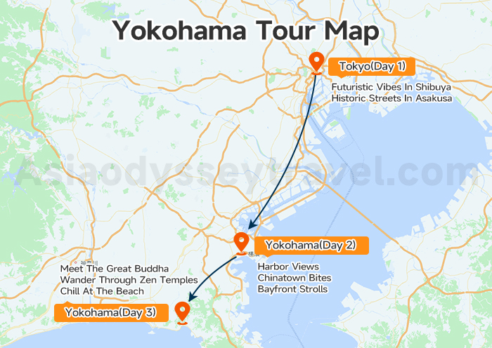
Day 1: Explore Tokyo
Start your trip in the capital – Tokyo's got it all: futuristic vibes in Shibuya, historic streets in Asakusa, and endless eats and shops in between.
Day 2: Day Trip to Yokohama
Just 30 minutes from Tokyo, Yokohama offers a breath of fresh (sea) air with its harbor views, quirky museums, Chinatown bites, and bayfront strolls. Easy day trip, or stay the night if you want to slow it down.
Day 3: Visit Kamakura
From Yokohama, ride 25 minutes to Kamakura to meet the Great Buddha, wander through Zen temples, or chill at the beach. It's the perfect mix of culture and relaxation before heading back.
Explore Yokohama & Japan with Asia Odyssey Travel
Planning just a quick day trip? Or want to dive deeper into Japan's most exciting cities? Wherever you're headed - Tokyo, Yokohama, Kyoto, Osaka, Mount Fuji, or beyond - we've got the routes, rides, and guides to make it smooth and memorable.
At Asia Odyssey Travel, we offer:
✅ Affordable Japan group tours
✅ Tailored private tours: Tokyo Tours, Kyoto Tours, Osaka Tours, Mount Fuji Tours, and more
✅ Comfortable intercity transfers with expert local guides and experienced drivers
✅ Updated toursit maps for different destinations: Tokyo map, Kyoto map, Hokkaido map, and more
✅ Various itineraries designed for different seasons
✅ Ultimate Travel Guide: Japan travel guide, Japan tourist map, and transportation guide between cities.
We'll make sure your Japan journey is effortless, exciting, and exactly how you imagined it.


")


")
")
")
")
: Travel & Sightseeing Map | 2026")
")
: Tourist & Sightseeing Map | 2026")
")
 Map: Tourist, Sightseeing & Metro Map of Nagoya")