Where is Kobe on Japan Map: Location & Overview
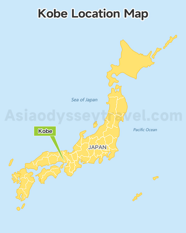
If you're looking at a map of Japan for the first time, finding Kobe is actually pretty easy. Look for Osaka first - it's one of the big cities in central Japan. Kobe sits just 30 minutes west of Osaka, right on the coast.
Kobe is located in southern Hyogo Prefecture, sandwiched between Osaka Bay and the Rokko Mountains. On any Japan map, you'll see it marked along the Seto Inland Sea coastline.
It's part of the famous Kansai region, which means you're perfectly positioned to explore Osaka, Kyoto, and Nara - all within an hour's train ride.
Kobe City Map: Complete Guide to Districts & Neighborhoods
Now that you know where Kobe sits in Japan, let's zoom in on the city itself. A good Kobe city map is like having a local friend show you around - it tells you not just where things are, but which areas match what you're looking for.
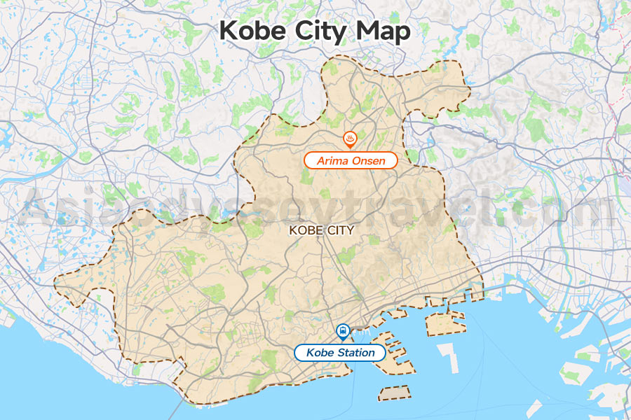
The first thing you'll notice on any Kobe city map is how the city stretches east to west along the coast. The city stretches about 30 kilometers east to west, but it's only a few kilometers wide in most places.
Most of the places you'll want to visit are in a central strip that's surprisingly easy to navigate.
Sannomiya is Kobe's center - literally. On any Kobe city map, you'll see all the train lines meet here. This is where you'll find hotels, shopping, and restaurants. It's your navigation anchor point. Lost? Just head back to Sannomiya.
West of Sannomiya lies Motomachi, Kobe's historic foreign quarter. Your map shows it connecting to Nankinmachi (Chinatown) - perfect for an afternoon of shopping and dumplings.
North from here, the Kitano district climbs the hillside with its preserved Western houses from the 1800s.
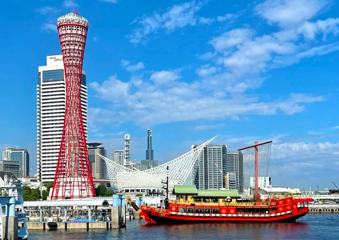
The harbor area spreads south from Motomachi. Kobe Port Tower, Meriken Park, and the Maritime Museum are all within a 15-minute waterfront walk.
East of center, the Nada district is sake heaven - five breweries are marked on most tourist maps.
For something special, Arima Onsen appears on the northern edge of your Kobe map. Yes, these hot springs are still within city limits, just 30 minutes into the mountains from Sannomiya. Unwind in a Mountain Onsen >>
Kobe Attractions Map: Top Sights & Hidden Gems
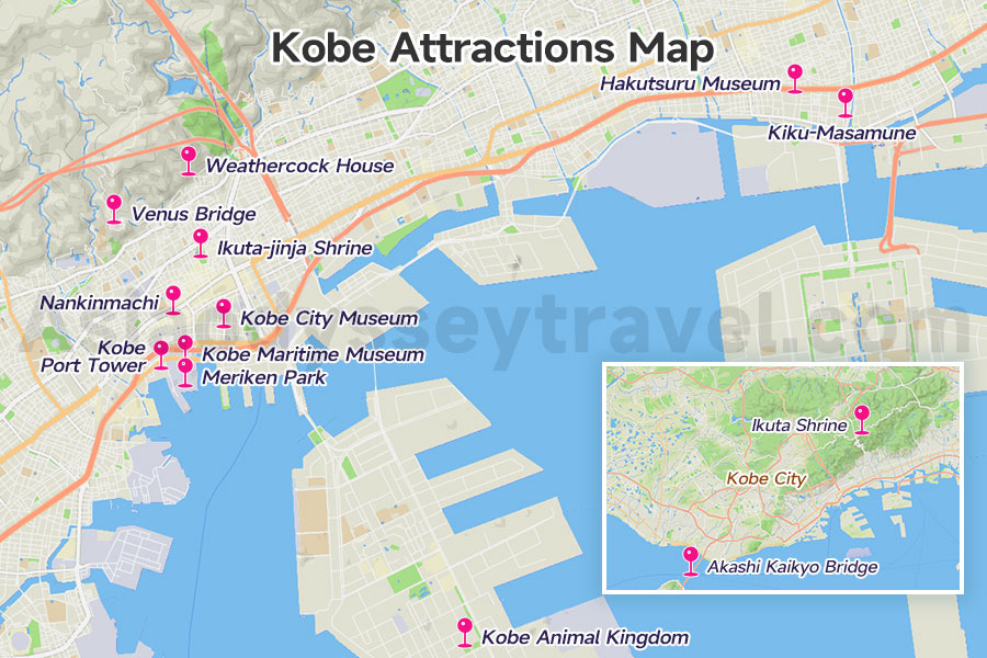
Your Kobe attractions map is about to become your most-used travel tool. Instead of wandering aimlessly, you'll know exactly where to find that perfect view, that must-try beef restaurant, or that quiet shrine away from the crowds.
Kobe Port Tower stands out on any map with its distinctive red steel frame. Right next to it, you'll find the Maritime Museum with its unique white roof that looks like ocean waves.
These two landmarks in Meriken Park make orientation easy - if you can see the tower, you know where you are.
The Kitano district appears on your attractions map as a cluster of historic houses. The most famous is Weathercock House (Kazamidori no Yakata), but here's a tip: the lesser-known houses like the French House offer better views and smaller crowds.
Nankinmachi (Chinatown) takes up just four blocks on your map, but packs in over 100 shops and restaurants. The central plaza often hosts performances, especially during Chinese New Year.
Now for some gems that might not appear on basic tourist maps. Ikuta Shrine, tucked behind the shopping streets near Sannomiya, is where locals go for good luck in love.
The Kobe City Museum near Motomachi has fantastic exhibitions but rarely sees foreign visitors.
Head east on your map to find the Nada sake district. Hakutsuru and Kiku-Masamune breweries offer free tours and tastings.
For views, your Kobe map should highlight three spots: Venus Bridge for night city views, Kobe Port Tower's observation deck for 360-degree panoramas, and the Rokko Cable Car for mountain-top vistas. That cable car also leads to Rokko Garden Terrace - sunset here beats any expensive restaurant view.
Families should note Kobe Animal Kingdom's location near Port Island. Same goes for the Akashi Kaikyo Bridge - technically outside Kobe city, but worth the 30-minute train ride to see the world's longest suspension bridge.
Kobe City Loop Bus Map: Routes, Stops & Travel Tips
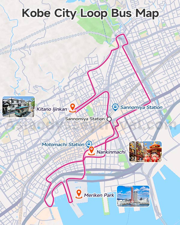
The Kobe City Loop Bus is your secret weapon for sightseeing. This green retro-style bus follows a fixed route with 17 stops, taking about 65 minutes for a complete loop.
On your Kobe City Loop Bus Map, you'll see it starts at Sannomiya Station, heads north to Kitano, west to Motomachi, south to the harbor, then back to Sannomiya.
Key stops on your loop bus map include Kitano Ijinkan (for the foreign houses), Meriken Park (for the port area), and Nankinmachi (for Chinatown).
At Sannomiya and Motomachi, you can easily switch to JR or subway lines. This makes the loop bus perfect for reaching attractions, then using faster trains to return to your hotel.
Pro tip from our Asia Odyssey Travel team: Board at Sannomiya and ride the complete loop first. This gives you a 65-minute overview of Kobe's layout. Note which stops interest you, then hop off on your second round.
Kobe Train Map & Metro: JR, Subway, Hankyu & Hanshin Lines
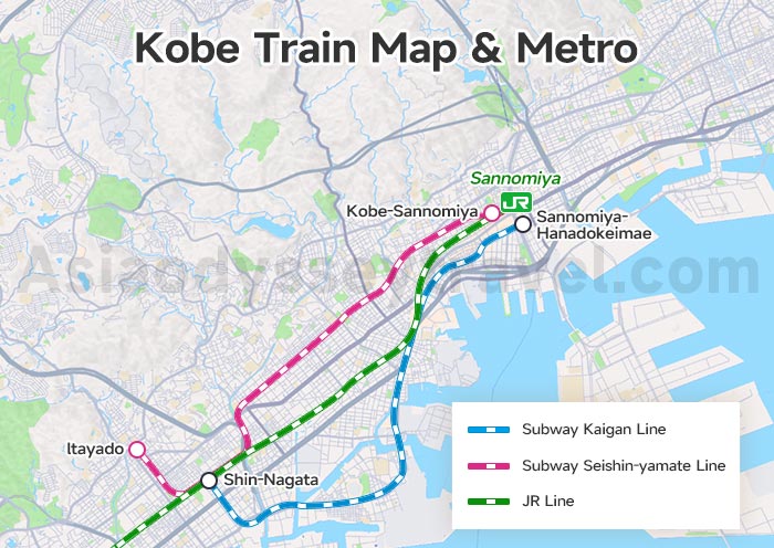
On this Kobe train map you’ll see 4 different companies running trains through one city.
The JR Line is your workhorse. On the train map, it runs east-west along the coast, connecting Kobe to Osaka and Kyoto. Key stops include Sannomiya (city center), Motomachi (Chinatown area), and Kobe Station.
The Subway appears on your map as a single line running from the coast up into the mountains. It's particularly useful for reaching Shin-Kobe Station (for bullet trains) and continues north to Arima Onsen. Only 7 stops make it easy to understand.
Hankyu and Hanshin lines run parallel to JR but serve different areas. Hankyu runs through the northern neighborhoods - great for reaching quieter residential areas.
Hanshin hugs the coast more closely, perfect for the Nada sake district. Both lines are private companies, so JR Passes don't work here.
At Sannomiya, all these lines converge. Your train map shows this as a cluster of connected stations.
Yes, they have different names (JR Sannomiya, Hankyu Kobe-Sannomiya, etc.), but they're all within a 5-minute walk. Follow the signs or just head above ground and walk. Experience Japan at Bullet Train Speed >>
Kobe Travel Planning Map: Best Areas to Stay, Eat & Explore
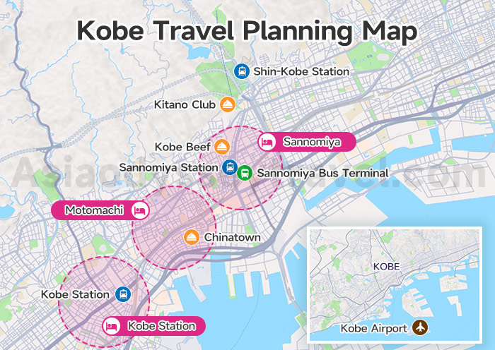
Your Kobe travel map becomes truly useful when you know where to sleep, what to eat, and how to get around.
Recommended Accommodation Areas in Kobe
Sannomiya remains the top choice for good reason - it's Kobe's center with the most hotel options. Motomachi offers a nice alternative, putting you closer to Chinatown and the harbor while still being central.
For budget travelers, the area around Kobe Station has cheaper options, though you'll need one extra train stop to reach most attractions.
Where to Eat: Kobe's Food Map
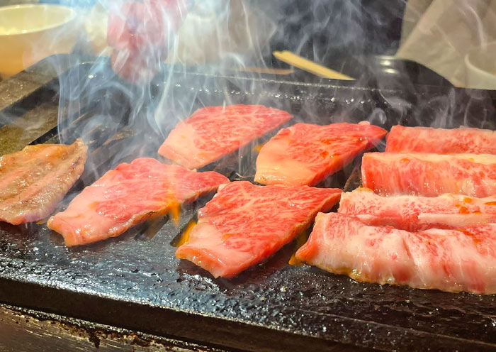
Kobe Beef: Kobe Beef Steak Ishida (Kitanagasa-dori)
Chinatown: Roushouki (Nankinmachi) - famous for butaman pork buns.
Sake & Japanese: Kobe Shushinkan (Nada) - brewery restaurant with sake tasting flights; Ganko Sushi (Sannomiya) - reliable conveyor belt sushi, English menu available.
International: Kitano Club (Kitano) - French fine dining in a historic house; Gaylord Indian Restaurant (Kitano) - authentic North Indian, great vegetarian options.
Seafood: Ganko Harbor Restaurant (Mosaic) - fresh sushi with harbor views; The Oyster Bar Kobe (Harborland) - all-you-can-eat oysters.
Department store food floors: Daimaru basement (Motomachi) - try Kobe croquettes from Asahiya; Sogo basement (Sannomiya) - excellent bento boxes and wagyu beef sandwiches. Taste Your Way Through Japan >>
Transportation Hubs with Locations
Sannomiya Station (1 Chome Sannomiyacho, Chuo Ward) - Dead center of Kobe, where JR, Hankyu, Hanshin, and subway lines meet.
Shin-Kobe Station (1 Chome-3-1 Kamokogahara, Chuo Ward) - 2km north of city center. Shinkansen (bullet train) only.
Kobe Station (3 Chome-1-1 Aioicho, Chuo Ward) - 2.5km west of Sannomiya.
Kobe Airport (Kobe Airport Island) - 8km south of center on Port Island.
Sannomiya Bus Terminal (Connected to Mint Kobe building).
Must Try Food in Japan: 20 Unique Japan Food & Cuisine in Tokyo, Osaka, Kyoto.. 2026
Kobe in the Kansai Region: Osaka-Kobe-Kyoto Regional Map
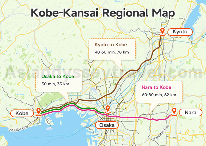
Osaka to Kobe: 30 min 35 km
Kyoto to Kobe: 40-60 min 78 km
Nara to Kobe: 60-80 min 62 km
As we mentioned earlier, Kobe is part of the Kansai region. Osaka, Kyoto, and Nara - also in Kansai - are typically explored together with Kobe as neighboring destinations.
On this Kobe-Kansai regional map, we'll examine these surrounding areas and the transportation connections between them.
Osaka to Kobe Map
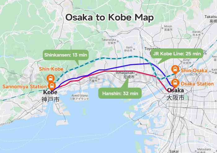
Osaka to Kobe: Distance, Train, Shinkansen, Ferry & More
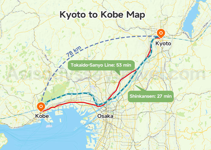
Kyoto to Kobe Map
Discover Kanazawa & Japan with Your Local Guide - Asia Odyssey Travel
Explore Japan with Asia Odyssey Travel! We are a local travel company with an office in Tokyo. We are here to help you enjoy the best of Japan. We offer simple, fun, and real local tours.
Our Japan Tours at a Glance:
✅ Japan Tours: 60+ Best Tour Packages
✅ Japan Group Tours: 6+ great value trips, including cherry blossoms & classical routes.
✅ Theme Tours for Kobe: Family Tours · Food Tours · Onsen Tous · Train Tours · Culture Tours
Helpful Guides for Your Japan Trip:
Japan Travel Guide & Travel FAQs: All you need to know before you go.
Useful Advice: How to Plan · Best Time to Visit · Cherry Blossom · Things to Do · Beautiful Places · Temples · Food · Maps · Rainy Season
Contact us now and start planning your dream Japan tour.


")


")
")
")
: Travel & Sightseeing Map | 2026")
")
: Tourist & Sightseeing Map | 2026")
")
 Map: Tourist, Sightseeing & Metro Map of Nagoya")


")