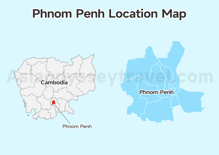
Phnom Penh Location Map: Where Is It?
Phnom Penh is the capital of Cambodia, located in the south-central part of the country.
For travelers, what really matters is how it connects to other places:
- To Siem Reap (Angkor Wat area): 5–6 hours by bus
- To Sihanoukville (beaches & islands): 4–5 hours
- To Ho Chi Minh City, Vietnam: about 6 hours by bus (including border procedures)
Phnom Penh is Cambodia's transportation hub. Most travelers either start here or pass through it.
Phnom Penh City Map: Layout of the Capital City
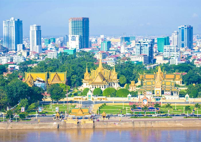
Phnom Penh sits at the meeting point of three rivers: Mekong River, Tonlé Sap River, and Bassac River.
The river junction is not just geography — it defines the city.
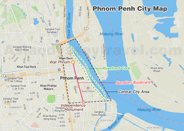
The Riverfront Core
The main tourist zone sits directly at this river confluence. This is where you'll find the most walkable area, the highest concentration of attractions, restaurants, and many hotels.
If it's your first time, this is your mental anchor point.
Norodom Boulevard – The Spine of the City
Running north to south through central Phnom Penh is Norodom Boulevard, the most important tree-lined avenue in the capital.
It connects:
- Wat Phnom (the city's birthplace in the north)
- Royal Palace
- National Museum of Cambodia
- Independence Monument (in the south)
If you understand this boulevard and the riverfront, you basically understand Phnom Penh.
Phnom Penh Tourist Attractions Map
Phnom Penh's key attractions are mainly clustered around the city center and along the Tonlé Sap River, making it easy to explore by tuk-tuk, bike, or even on foot.
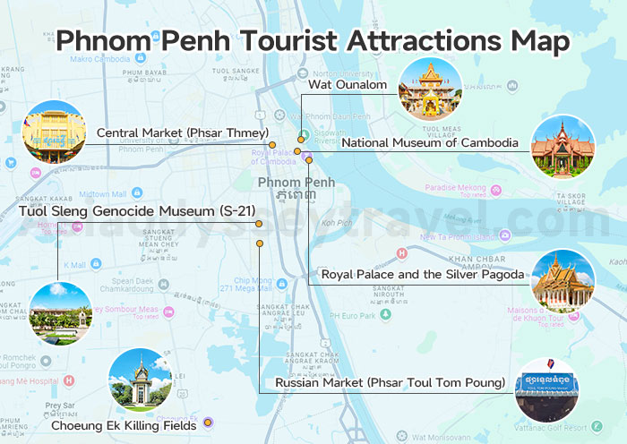
This Phnom Penh Tourist Attractions Map shows the following popular tourist spots in the city. A 1-2 days is enough to explore its highlights with our map.
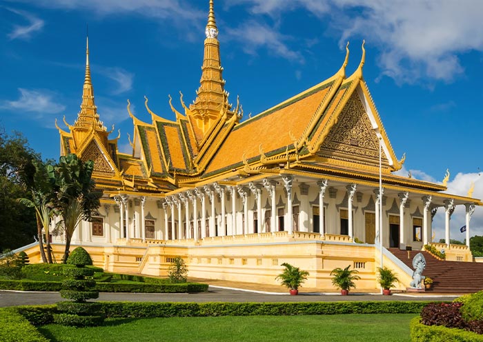
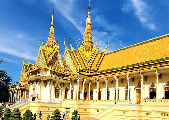
Royal Palace and the Silver Pagoda: Sitting side by side near the confluence of the Mekong and Tonlé Sap Rivers. Heart of Phnom Penh with golden spires, manicured gardens, and cultural treasures.
National Museum of Cambodia: Easily recognized by its red terracotta architecture and traditional Khmer roof.
Wat Ounalom: Near Street 130 and Sisowath Quay, an important temple and spiritual center for Cambodian Buddhism.
Central Market (Phsar Thmey): It's known for its iconic yellow dome and lively stalls selling everything from souvenirs to local snacks.
Tuol Sleng Genocide Museum (S-21): Southwest of the center, about 15–20 minutes by tuk-tuk. It's a sobering place to learn about the Khmer Rouge period.
Choeung Ek Killing Fields: Around 30–40 minutes from downtown, another key site that offers insight into Cambodia's tragic history. It's often visited together with Tuol Sleng.
Russian Market (Phsar Toul Tom Poung): A more relaxed vibe, south of the city center. It's great for souvenirs, art, and local eats.
Wat Phnom: Sits west of the center, perched on a small hill and considered the spiritual birthplace of the city.
Phnom Penh Airport Map (with Current Flight Situation)
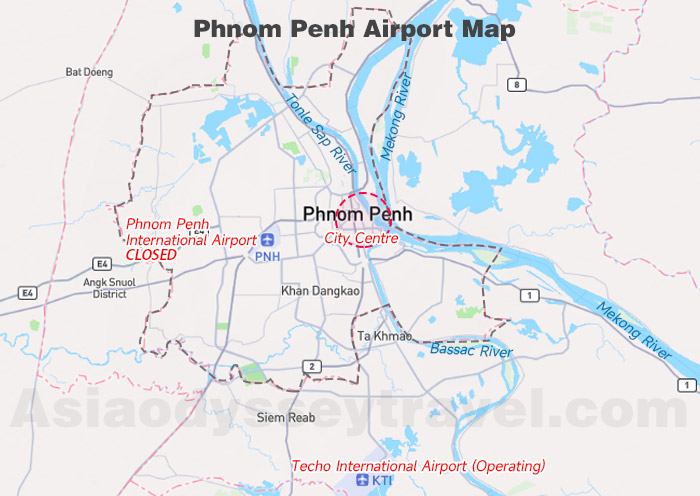
If you look at a map, you'll notice two airports near Phnom Penh — reflecting a recent major transition in the city's aviation history.
| Comparison | Techo International Airport | Phnom Penh International Airport |
|---|---|---|
| Status | ✅ Operating (Main Airport) | ❌ Closed for commercial passenger flights |
| Change Date | Opened September 9, 2025 | Closed September 9, 2025 |
| Distance to Center | ~24 km south | ~7–10 km west |
| Character | Brand new, 4F-standard hub airport | Former airport, historical site |
Important Note
Since September 9, 2025, all commercial passenger flights operate from: Techo International Airport
The former Phnom Penh International Airport has officially stopped handling commercial passenger flights.
Getting from the New Airport to the City
- Distance: About 24 km
- Travel time: 45–60 minutes (traffic dependent)
- Best option: Taxi or pre-arranged transfer
- Grab is available but may have longer wait times
Because the new airport is significantly farther from downtown, allow extra buffer time.
Domestic & International Flights
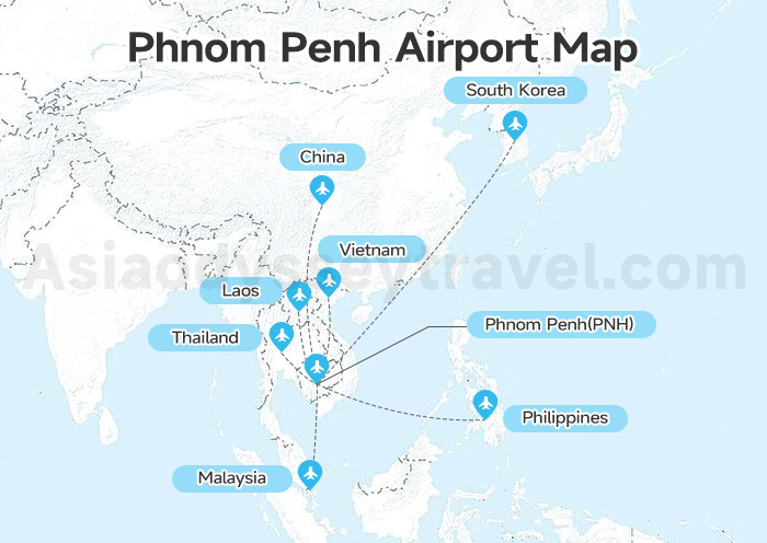
From the Phnom Penh Airports Map, you can clear its domestic and international flight routes, deciding which city you can choose to fly from. Or it helps to arrange your trip in Cambodia with its domestic flight routes from Phnom Penh.
International Routes (Asia):
- Thailand: Bangkok (BKK, DMK)
- Vietnam: Ho Chi Minh City, Hanoi
- Malaysia: Kuala Lumpur
- Singapore
- China: Hong Kong, Guangzhou, Kunming, Chengdu (some seasonal)
- South Korea: Seoul
- Laos & Philippines: Limited or seasonal flights (Vientiane, Manila)
Domestic Routes: Siem Reap, Sihanoukville
Phnom Penh Hotel Map: Where to Stay
Choosing the right area matters more than choosing a fancy hotel here. Phnom Penh is compact, but not every neighborhood feels convenient for short stays.
Here's how to decide.
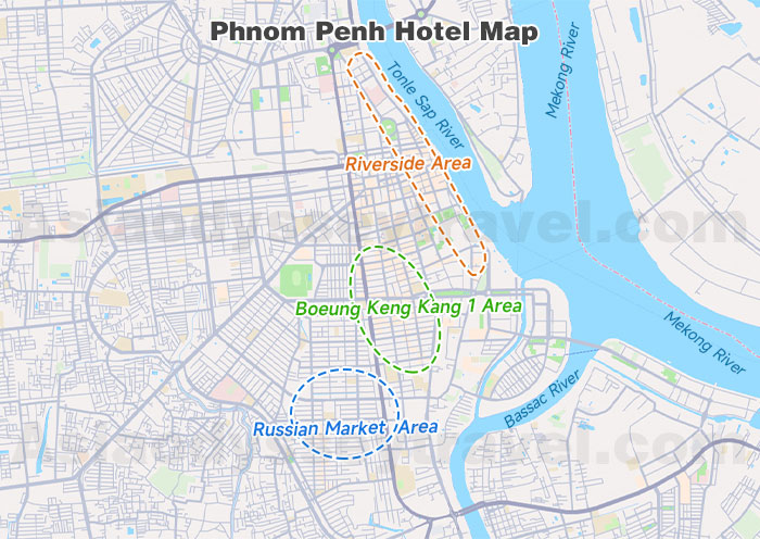
Riverside Area – Best for First-Time Visitors
Best for: Short stays, sightseeing, easy walking
Why stay here?
- Walking distance to Royal Palace & National Museum
- River views
- Easy access to restaurants and tour pickup points
Downside:
- Some streets can be noisy at night
If you only have 1–2 nights, this is the safest choice.
BKK1 (Boeung Keng Kang 1) – Comfortable & Modern
Best for: Couples, solo travelers, digital nomads
Why stay here?
- Clean streets
- Great cafés
- Boutique hotels
- More relaxed nightlife
It's about 10–15 minutes by tuk-tuk to the Royal Palace area.
This neighborhood feels more international and polished.
Russian Market (Tuol Tom Poung) – Budget & Local Vibe
Best for: Longer stays, budget travelers
Why stay here?
- Affordable guesthouses
- Artisan markets
- Trendy hidden cafés
It's slightly farther from the main monuments, but easy by Grab (10–15 minutes).
Phnom Penh City Bus Map: Travel around the City
If you are looking for a budget friendly way to explore the city and its popular spots, the growing and affordable City Bus system will take you there.
It's very cheap for around 1,500 riel (about $0.40 USD) per ride and usually runs from 5:30 AM to 8:30 PM. There are over 15 routes, each with a color and number (e.g., Line 01 – Red, Line 02 – Blue, etc.). We'll highlight the main routes that you may need when exploring the city.
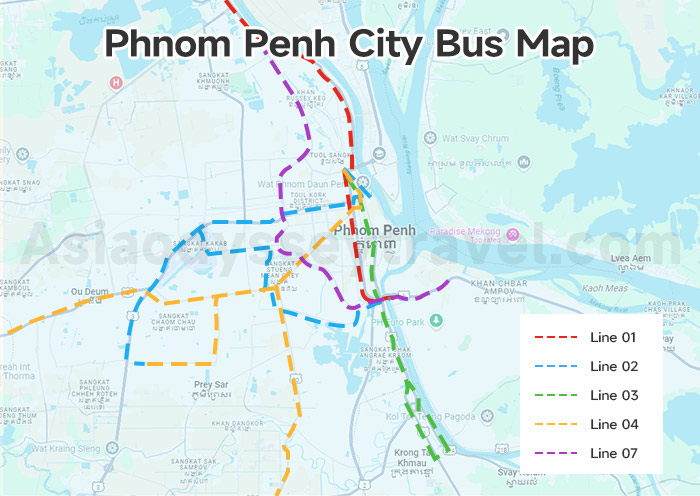
Line 01 – Red Line
Route: Kilometer 9 → Night Market → Central Market → Olympic Stadium → Borey Santepheap
Useful for:
- Wat Phnom (get off near the Night Market stop)
- Central Market
- Local neighborhoods & food spots
Line 02 – Blue Line
Route: Ta Khmao → Russian Market (Toul Tom Poung) → Olympic Stadium → Central Market → Old Stadium
Useful for:
- Russian Market – great for souvenirs, local food, and clothes
- Olympic Stadium – local hangout, sometimes events
- Central Market
Line 03 – Green Line (Airport Line)
Route: Phnom Penh International Airport → Russian Blvd → Olympic Stadium → Central Market → Night Market
Useful for:
- Getting to/from the Airport
- Central Market
- Riverfront area & Royal Palace (via Night Market stop, then short walk)
Line 04 – Yellow Line
Route: Chbar Ampov → Kbal Thnal → Independence Monument → Royal Palace area → Wat Phnom
Useful for:
- Royal Palace & Silver Pagoda
- Independence Monument
- Wat Phnom
- Riverside (Sisowath Quay)
Line 07 – Purple Line
Route: Chbar Ampov → Monivong Blvd → Orussey Market → Olympic Stadium
Useful for:
- Monivong Blvd – one of the main roads, easy access to many shops and restaurants
- Orussey Market – a local market experience
- Olympic Stadium
Other Ways to Get Around
Tuk-Tuks (Remork): Widely used, flexible, and easy to find. You can use apps like PassApp or Grab to book tuk-tuks with clear prices.
Motorbike taxis (motos): Fast for short rides, but less safe.
Private Cars / Taxis: Can be arranged via Grab or hotels.
Bicycles & Walking: Good for short distances in the city center or riverfront.
Phnom Penh Transportation Map
For most travelers, Phnom Penh is not the final destination when visiting Cambodia. Angkor Wat is. So, traveling to Angkor Wat in Siem Reap from Phnom Penh is quite important!
Phnom Penh to Siem Reap Map
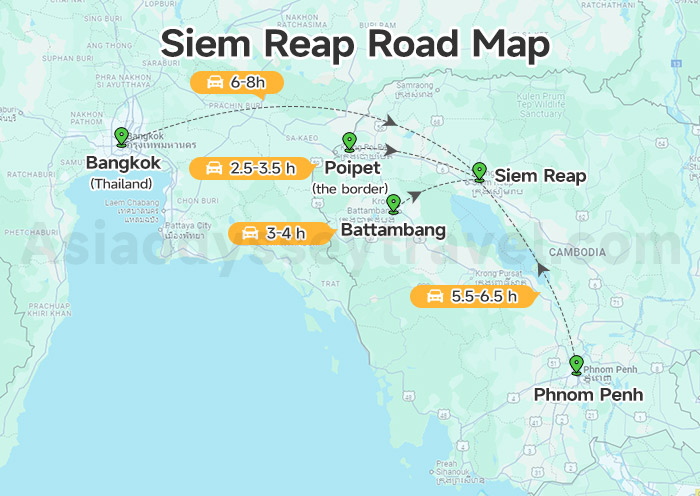
Siem Reap lies about 320 kilometers northwest of Phnom Penh. It's a popular travel route for anyone visiting Angkor Wat. You can choose from different ways to get there based on your time and budget.
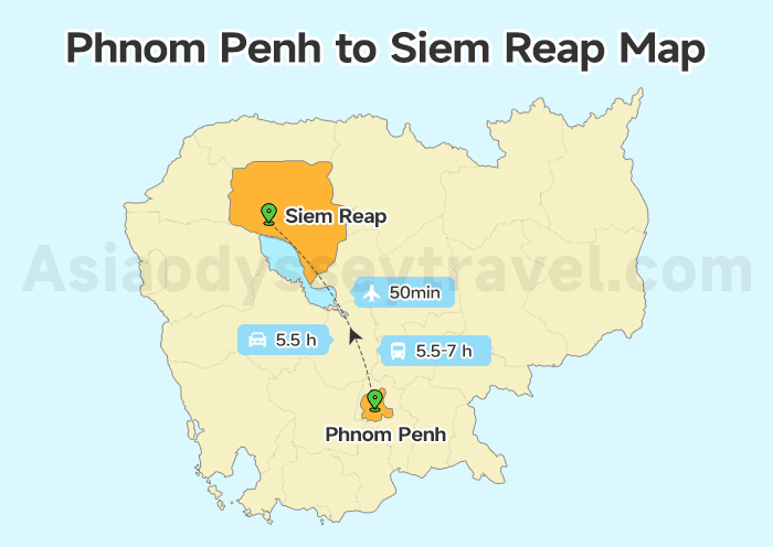
- By Bus: Around 5 to 7 hours, with multiple departures daily.
- By Plane: Just a 50-minute flight, perfect if you want to save time.
- By Private Car/Taxi: Around 5 hours with more comfort and flexibility.
All overland options follow National Road No. 6, which offers scenic views of Cambodia's countryside, small villages, and green rice paddies along the way.
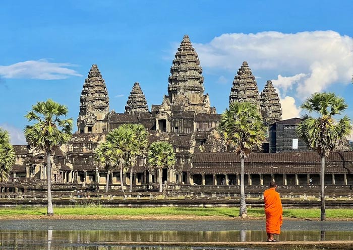
Phnom Penh to Angkor Wat Map
Angkor Wat, Cambodia's most iconic temple, is located just 6 km north of Siem Reap town.
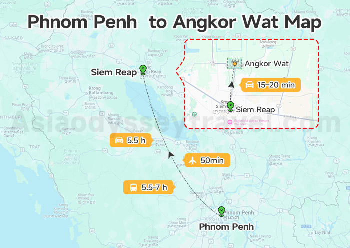
Here's how to get there from Phnom Penh:
First, travel from Phnom Penh to Siem Reap by bus, flight, or car. (Total distance: ~320 km)
Then, from Siem Reap, it's a short 15–20 minute ride by tuk-tuk, bicycle, or car to Angkor Wat. (Distance: ~6 km north of the town center)
So in total, the journey from Phnom Penh to Angkor Wat is about 326 km.
Phnom Penh Travel Map: Popular Itinerary
Itinerary #1: Phnom Penh City Exploration (1-2 days)
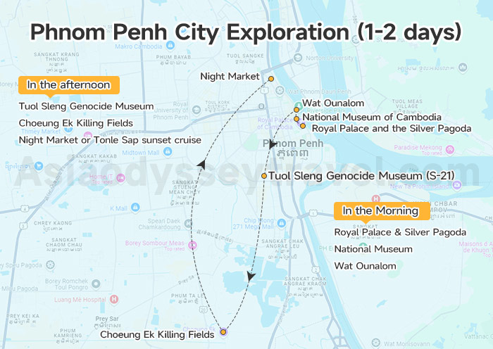
In the Morning: Royal Palace & Silver Pagoda → National Museum → Wat Ounalom (Lunch)
In the afternoon: Tuol Sleng Genocide Museum (S21) → Choeung Ek Killing Fields (Optional) → Night Market or Tonle Sap sunset cruise
Itinerary #2: Combine with Angkor Wat (5-7days)
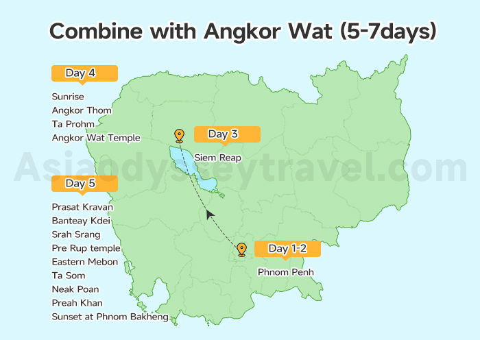
Spend the first 2 days in Phnom Penh, then drive to Siem Reap on the 3rd day.
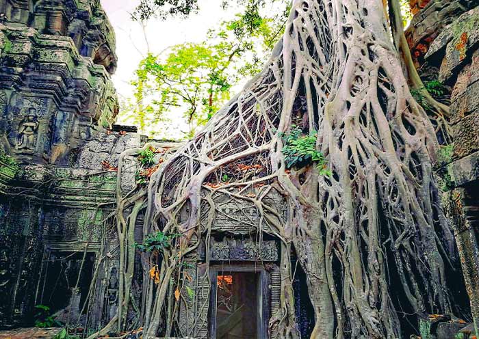
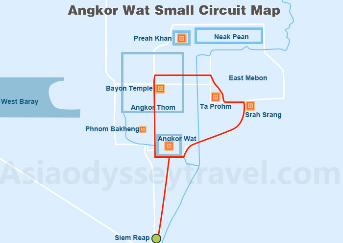
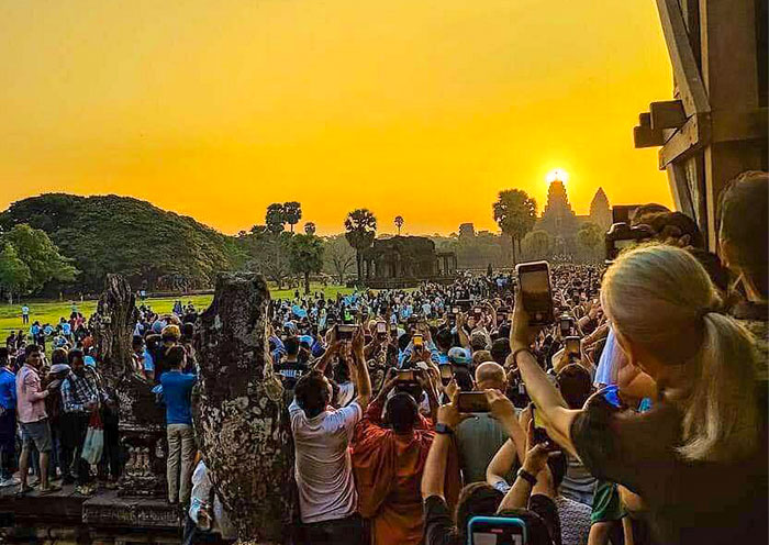
On the 4th day, enjoy the temples along the classic Angkor Wat Small Circuit: Sunrise → Angkor Thom → Ta Prohm → Angkor Wat Temple → Get back to your Hotel.
On the 5th days, turn to the Grand Circuit: Prasat Kravan → Banteay Kdei → Srah Srang → Pre Rup temple → Eastern Mebon → Ta Som → Neak Poan → Preah Khan → Sunset at Phnom Bakheng → Get back to your Hotel
If you are obsessed with the mysterious Angkor Wat temple, spend an extra 2 days to visit the more remote and less touristy Banteay Srei, Beng Mealea and Tonle Sap Lake.