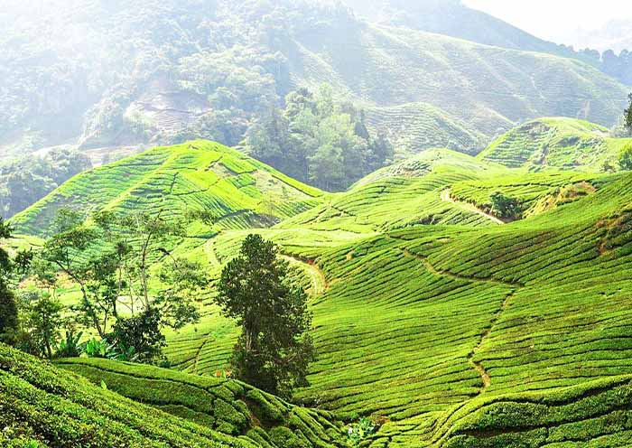
Cameron Highlands Location Map: Where Is Cameron Highlands Located?
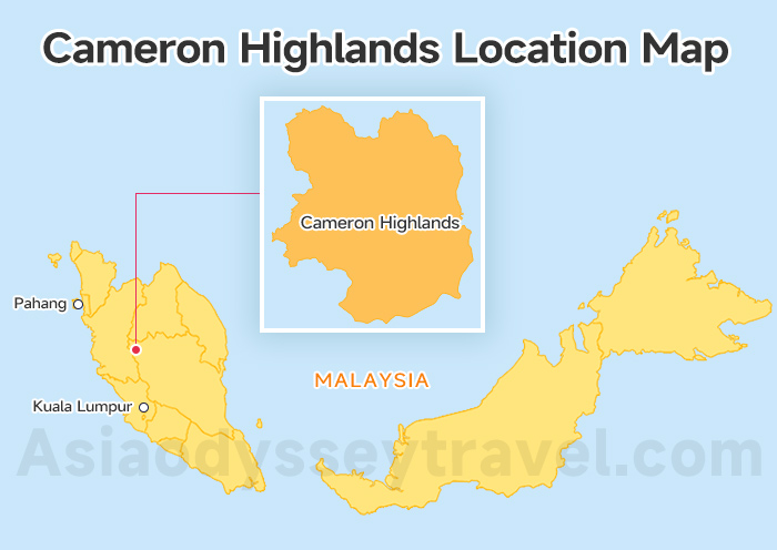
First things first: setting your compass!
Looking at the Cameron Highlands Location Map, you'll see this destination is nestled high up in the Titiwangsa Mountains in the state of Pahang.
It sits approximately 200 km north of Kuala Lumpur (KL) and about 250 km southeast of Penang.
This high-altitude spot is the reason for the mild weather, usually a refreshing 10-25℃. It's the perfect place to breathe easy and feel the cool air in Malaysia.
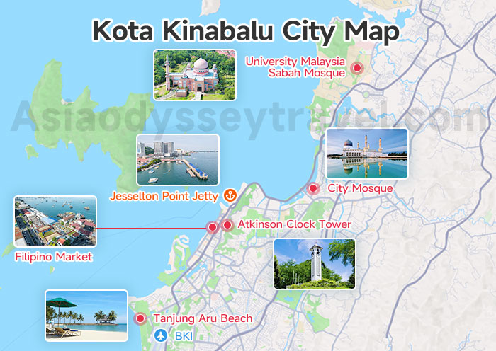
Cameron Highlands Attractions Map: The Must-Sees
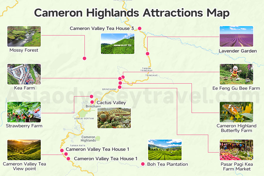
What are the must-see attractions in Cameron Highlands? Your Map of Cameron Highlands Attractions must include these incredible stops. These are the places that define the spirit of the Highlands!
| Attraction | The Local Vibe & Key Activity |
|---|---|
| Boh Tea Plantation | The iconic, rolling green carpet! A mandatory stop for a factory tour, the best views, and a fresh cup of tea. |
| Cameron Valley Tea View Point | The second major estate, featuring stunning terraced views and easily accessible from Tanah Rata. |
| Cameron Valley Tea House 1 | The original and largest shop, offering stunning, terraced views and easily accessible from Tanah Rata. |
| Cameron Valley Tea House 2 | Features a great, elevated viewing deck over the valley, often less crowded than Tea House 1. |
| Cameron Valley Tea House 3 | The newest house, offering modern architecture and closer access to northern farms. |
| Mossy Forest (Gunung Brinchang) | Mystical, ancient, and often foggy. Walk the boardwalks in this high-altitude cloud forest where every surface is covered in moss. |
| Pasar Pagi Kea Farm Market | The region's largest daily bazaar. Essential for fresh produce, local street food, and souvenirs. |
| Lavender Garden | A surprisingly massive floral wonderland, bursting with color and fragrance. |
| Strawberry Farm | Pick your own fresh, juicy strawberries! A delightful, easy-going farm experience. |
| Cactus Valley | Explore a giant collection of cacti, succulents, and other ornamental temperate-climate plants. |
| Cameron Highland Butterfly Farm | Walk among tropical butterflies, colorful insects, and small animal exhibits. Great for families. |
| Ee Feng Gu Bee Farm | Learn about the local honey production and taste some delicious, fresh Highlands honey. |
| Kea Farm | A bustling morning market famous for its fresh produce and local vibe. |
Cameron Highland Tourist Map: The Asia Odyssey Travel's 2-Day Plan
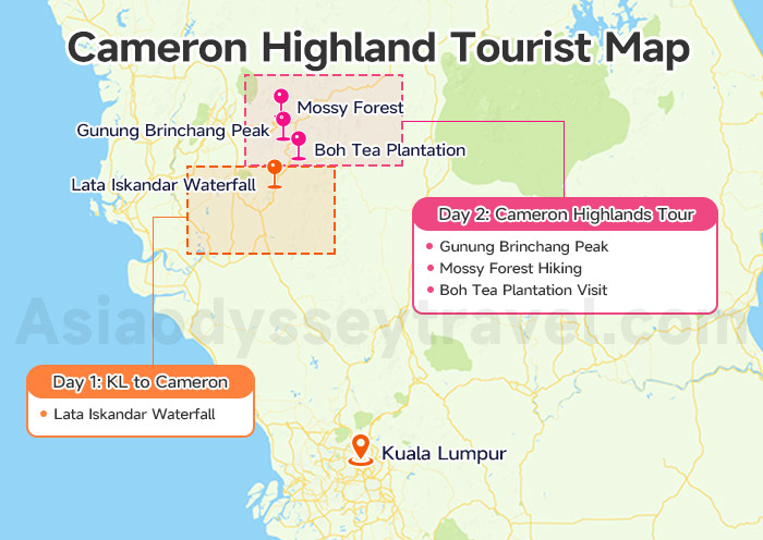
This detailed itinerary serves as your personal Cameron Highland Tourist Map, guiding you through the 2 best days you could spend here.
Day 1: KL to Cameron by Car (The Scenic Journey)
Your journey up is an attraction in itself! If driving from KL, you'll be taking the Tapah route.
| Activity | Focus | Time | What to Expect |
|---|---|---|---|
| KL Departure & Drive | Begin your scenic drive from Kuala Lumpur. | 2 hours (driving) | Stock up on snacks; the views get incredible as you ascend! |
| Lata Iskandar Waterfall | A beautiful, roadside waterfall on the Tapah route. | 1 hour | A crucial, refreshing leg-stretcher and photo opportunity before the final climb. |
| Arrival & Check-in | Arrive in Cameron Highlands. | 0.5-1 hour | Settle in, grab a delicious steamboat dinner (it's a Highlands tradition!) by yourself, and enjoy the crisp evening air. |
Day 2: Cameron Highlands Tour (Tea, Trails and Peaks)
This is your day for the iconic Highlands experiences!
| Activity | Focus | Estimated Time | Local Tip |
|---|---|---|---|
| Gunung Brinchang Peak | Hike to the peak for panoramic views of the valleys below. | 1.5 hours | Go early! The views are clearest before the afternoon mist rolls in. |
| Mossy Forest Hiking | Wander the unique boardwalks of the Mossy Forest. | 1-2 hours | Access is tight; our guided tour includes the best way to get there and entrance permits. |
| Boh Tea Plantation Visit | Tour the factory, enjoy the famous viewpoint, and savor afternoon tea. | 2-3 hours | Try the local strawberry scone set—it's pure heaven! |
Note: It's the exact flow we use on our 8 Days Kuala Lumpur to Penang Tour via Cameron Highlands to ensure you see everything important without rushing!
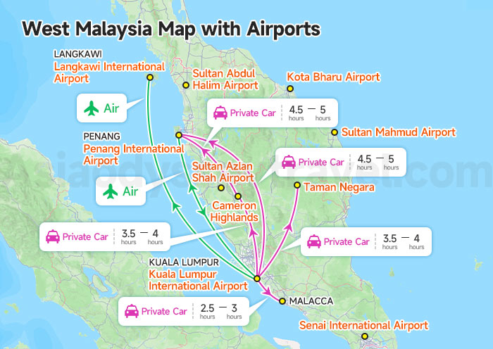
Getting Here: Ipoh / Penang / Kuala Lumpur to Cameron Highlands Map
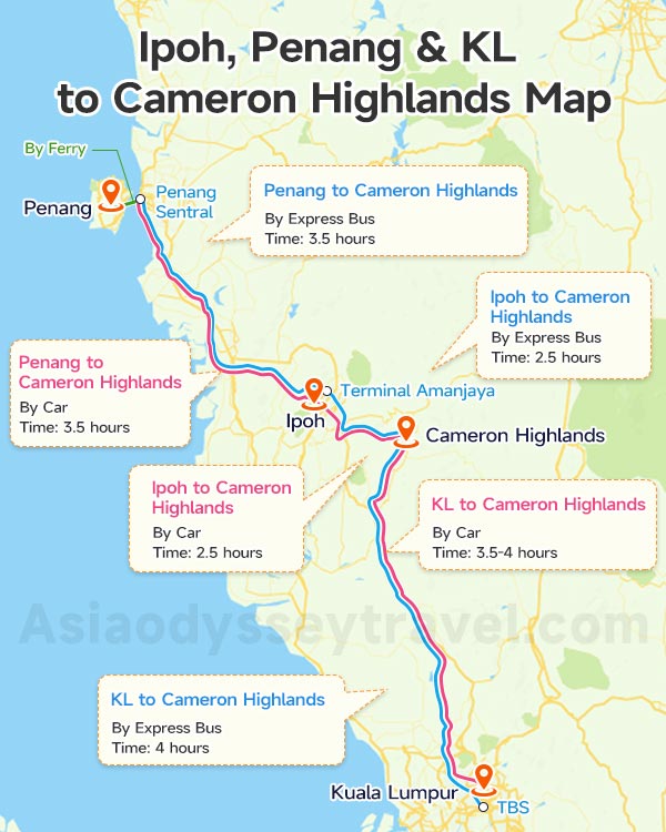
Planning your arrival is key to a smooth trip!
Here's a quick breakdown of your travel options, acting as your crucial Kuala Lumpur to Cameron Highlands Map, Penang to Cameron Highlands Map, and Ipoh to Cameron Highlands Map.
| Departure | Transport | Route/Destination | Time | Key Info |
|---|---|---|---|---|
| Kuala Lumpur (KL) | Car | Tapah Route to Cameron Highlands | 3.5-4 hours | Shorter but steeper road with many hairpin turns. |
| Kuala Lumpur (KL) | Express Bus | Tanah Rata Bus Terminal (Terminal Freesia) | 4 hours | Depart from TBS (Terminal Bersepadu Selatan). |
| Penang | Car | Simpang Pulai Route to Cameron Highlands | 3.5 hours | Wider, gentler ascent. Preferred route for northern travelers. |
| Penang | Express Bus | Tanah Rata Bus Terminal (Terminal Freesia) | 3.5 hours | Depart from Penang Sentral or Sg. Nibong, requiring a transfer at Terminal Amanjaya in Ipoh. |
| Ipoh | Car | Simpang Pulai Route to Cameron Highlands | 2.5 hours | Wider, gentler ascent. Preferred route for northern travelers. |
| Ipoh | Express Bus | Tanah Rata Bus Terminal (Terminal Freesia) | 2.5 hours | Buses depart from Terminal Amanjaya (Ipoh). |
Ipoh Maps: Tourist Map of Old Town, Heritage Trail, Murals (2026)
Getting Around: Cameron Highlands Road Map & Cameron Highlands Trail Map
Navigating within the Cameron Highlands is arguably the most challenging part of the trip!
Public transportation barely exists, and the central road connecting all the main attractions is narrow and prone to heavy congestion, especially during weekends.
Because of these logistical hurdles, many travelers find that the most seamless way to explore is by booking a guided tour with Asia Odyssey Travel.
This lets you skip the parking nightmares, avoid tricky winding roads, and ensures you get to hard-to-reach spots (like the Mossy Forest) with a local expert.
If you prefer to navigate on your own, you'll need to rely on the following:
Cameron Highlands Road Map (The Lifeline)

The main road links all the major towns and attractions. This central Cameron Highlands Road Map artery can get very slow on weekends, so plan accordingly!
Rely on driving your own or rented vehicle, hiring a taxi, or using e-hailing services (like Grab).
- Tanah Rata to Brinchang: About 10 minutes (if no traffic).
- Brinchang to Boh Tea Estate: About 15 minutes (on a narrow, windy road).
Cameron Highlands Trail Map
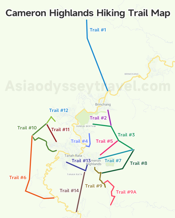
If you love hiking, you'll be checking out the Cameron Highlands Trail Map! The trails here are numbered (T1 to T14). Here are the opened ones:
| Trail No. | Route / Destination | Difficulty | Status & Notes |
|---|---|---|---|
| T1 | Gunung Brinchang (Starts near Brinchang Town Army Quarters) | Difficult (3-4 hours one-way) | A long, steep, and demanding climb to the peak. Guide highly recommended due to frequent overgrowth and poor signage. |
| T2 | Sam Poh Temple Link (Starts behind Sam Poh Buddhist Temple, Brinchang) | Difficult (1-2 hours) | Short but tough trek over rough, undulating, and poorly marked terrain. Used primarily to connect the temple to Trail 3. |
| T3 | Gunung Berembun (Starts at Arcadia Cottage, near the Golf Course) | Moderate to Difficult (2.5 hours one-way) | A popular main route to Mount Berembun. Intersects with Trails 2, 5, 7, and 8 at or near the summit. |
| T4 | Parit Waterfall (Starts near Forestry Department/Tanah Rata) | Easy to Moderate (1 hour round trip) | A very short, accessible, and well-maintained loop that leads to the Parit Waterfall. |
| T5 | MARDI Link (Starts at MARDI, Tanah Rata) | Easy (1 hour) | A connecting trail that merges with Trail 3 near the mountain base. |
| T6 | Cameron Valley Exit (Starts from Gunung Jasar Summit, descends to Bharat Tea Plantation) | Moderate to Difficult (2.5 hours descending) | Often used in combination with Trail 10 for a popular loop. Can be confusing and unmarked on the descent, leading straight to the tea estate. |
| T7 | Gunung Berembun Direct (Starts at MARDI, Tanah Rata) | Very Difficult (2 hours one-way) | A straight, very steep, and challenging ascent directly to the Gunung Berembun summit. |
| T8 | Robinson Waterfall Climb (Starts near Robinson Waterfall) | Very Difficult (3 hours one-way) | A difficult, long climb up to the Gunung Berembun area. |
| T9 & T9A | Robinson Falls / Habu Village (Starts near MARDI, Tanah Rata) | Moderate | T9 leads toward Robinson Falls and the old weather station; T9A is a less-used path toward Habu Village. |
| T10 | Gunung Jasar (Starts behind Oly Apartments, Tanah Rata) | Moderate to Difficult (1 hour ascending) | Very popular hike to the summit of Mount Jasar, often combined with Trail 6 for a loop. |
| T11 | Power Line Track (Starts near Trail 10, Tanah Rata) | Easy (30 minutes) | A wide, flat utility track used mainly to bypass the start of the steep climb on Trail 10 or connect to Trail 12. |
| Mossy Forest | Boardwalk Loop (Near Gunung Brinchang Peak) | Easy | Managed boardwalk area. Requires either a guided tour or a personal vehicle (and often a permit) to access. |
Local Warning: While many trails are accessible, they can be muddy, steep, and sometimes poorly marked. For the most challenging hikes—especially those that ascend major peaks—it's essential to go with a guide.
Contact us at Asia Odyssey Travel (Malaysia) to hiking the Cameran Highlands!
Cameron Highlands Hotel Map: Where to Stay in the Cameron Highlands?
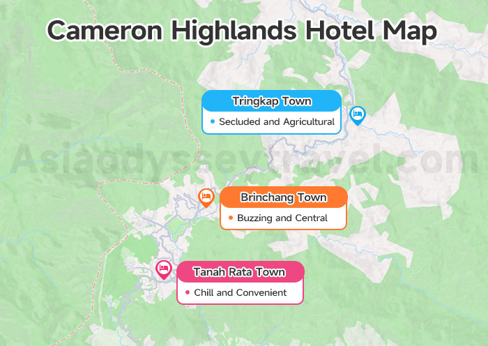
Choosing the right town is like selecting the perfect home base on your Cameron Highlands Hotel Map. Here's our local take on the best spots:
| Zone | The Vibe | Best For |
|---|---|---|
| Tanah Rata Town | Chill and Convenient. This is the main hub with great restaurants, cafes, and easy access to hiking trails. | Budget-conscious travelers, hikers, and those who prefer a laid-back evening atmosphere. |
| Brinchang Town | Buzzing and Central. Closer to the tea plantations, attractions, and home to the popular weekend night market. | First-time visitors, families, and those who want to be near the biggest sights. |
| Tringkap Town | Secluded and Agricultural. Quieter area, close to flower and strawberry farms. | Travelers seeking tranquility and a unique local, farming experience. |
Free Download Cameron highlands Maps and Explore with Asia Odyssey Travel (Malaysia)
You now have all the Cameron Highlands maps and local knowledge needed for a trip! If you prefer to simply relax and let us handle the driving and logistics, we'd love to help.
Asia Odyssey Travel (Malaysia) is a fully registered Malaysian company (ASIA ODYSSEY TRAVEL SERVICE MALAYSIA SDN.BHD, MATTA No: MA7091) based right in KL (37A, Jalan Dato Haji Harun, Cheras).
We're here for all your travel needs, whether it's our signature Malaysia Tours, an exciting Malaysia Borneo expedition, or organizing professional Malaysia MICE Tours.
Contact us—let's make your misty mountain escape happen!