East Java on Map: Pinpointing Indonesia's Land of Volcano
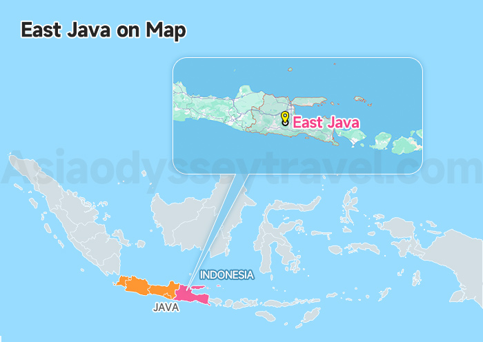
East Java occupies the eastern third of Java Island, stretching across roughly 48,000 square kilometers. That's about the size of the Netherlands or half of South Korea. The province runs from 7°12' to 8°48' south latitude, placing it firmly in Indonesia's tropical belt.
Central Java borders the province to the west. To the east lies the narrow Bali Strait, just 2.9 kilometers wide at its closest point.
A volcanic mountain chain runs east to west through the province's heart. Mount Semeru towers highest at 3,676 meters, making it Java's roof. Mount Bromo and Mount Ijen attract far more visitors.
The northern regions flatten into coastal plains, while southern plateaus roll toward dramatic ocean cliffs.
Java Island Map, Indonesia: Tourist Map with Attractions, Area & Itinerary
Yogyakarta Indonesia Map 2026 | Yogyakarta Map for Tourist
East Java Cities Map (Airports and Transportation within East Java Included)

This section shows you the urban centers that serve as your base camps. This map serves as your regional hub guide, showing the main cities that act as basecamps and the arteries (roads and rails) connecting them.
Surabaya: Located on the north coast, this is East Java's sprawling capital and your primary entry point. Its Juanda International Airport (SUB) is the main gateway, and its two major train stations (Gubeng and Pasar Turi) connect it to the rest of Java.
Malang: South of Surabaya, Malang is a pleasant, cooler highland city. It's an excellent alternative base for exploring Mount Bromo (especially via the scenic Tumpang route) and is the closest major city to the stunning Tumpak Sewu Waterfall. It's reachable by train or car from Surabaya.
Probolinggo: Situated east of Surabaya along the north coast road and railway line. This smaller city isn't a destination itself, but it's the crucial transit hub for most travelers heading to Mount Bromo using public transport (train + local minibus).
Banyuwangi: Located at the far eastern tip of Java, right across the strait from Bali. This city is the essential basecamp for exploring Ijen Crater and the location of the Ketapang ferry port for crossing to Bali.
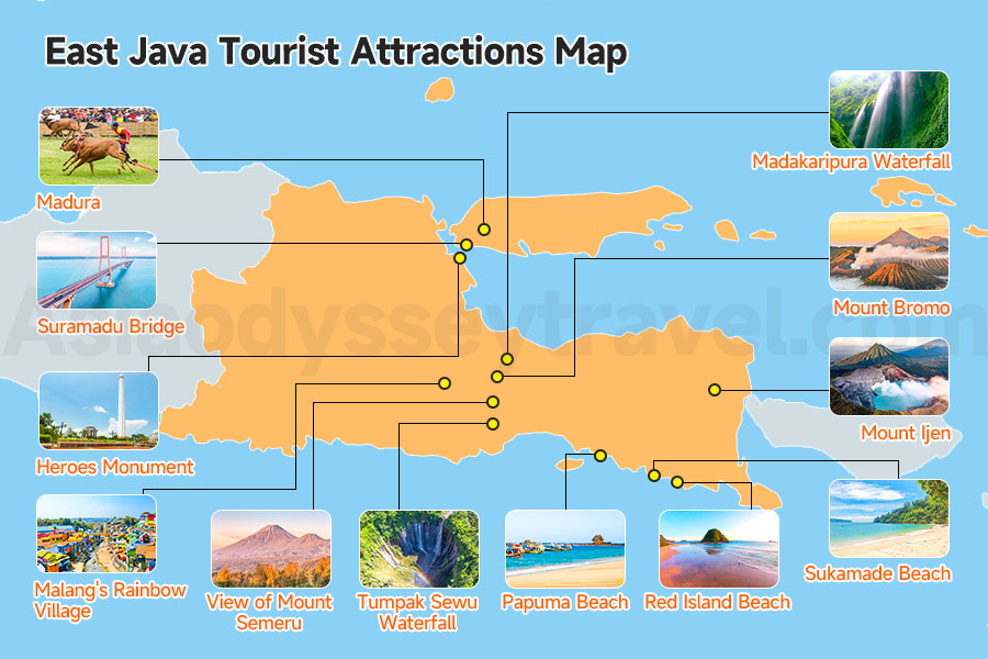
East Java Tourist Attractions Map - What to See and Do
Now that you understand the urban framework, let's explore the attractions that make East Java worth visiting in the first place.
Volcanic peaks concentrate in the mountain belt running east-west through the province's center. Waterfalls hide in the southern highlands where rivers tumble off plateaus.
Archaeological sites cluster southwest of Surabaya. Beaches line the entire southern coast and the eastern tip.
East Java is a vast province overflowing with natural wonders. To help you navigate this treasure chest, this map breaks down the main attractions by region.
While there's beauty scattered everywhere, we'll clearly highlight the absolute top 3 must-see attractions that define any trip to East Java: Mount Bromo, Tumpak Sewu Waterfall, and Mount Ijen. Look for these highlighted stars on the map!
Surabaya City Attractions (Brief Stop)
Surabaya serves as your entry point rather than your destination. Most travelers pass through without staying, but the city rewards those who allocate half a day. The ris Heroes Monument es 41 meters downtown, commemorating the 1945 independence battle.
The House of Sampoerna occupies a colonial building where workers still hand-roll clove cigarettes—the museum tells Indonesia's kretek story beautifully.
The Arab Quarter surrounding Sunan Ampel Mosque creates an atmospheric maze of narrow alleys filled with shops selling prayer items and traditional medicines.
Mount Bromo Area Attractions (Volcanic Heartlands)
This zone, roughly 80-130 kilometers southeast of Surabaya, contains East Java's most concentrated cluster of must-see attractions.
⭐ Mount Bromo: The undisputed superstar. Famous for its otherworldly sunrise views from viewpoints like Penanjakan, the vast Sea of Sand, and the experience of hiking to the crater rim.
⭐ Tumpak Sewu Waterfall: Located south towards Malang, this absolutely breathtaking waterfall resembles a giant curtain of water plunging into a jungle canyon. Often called Indonesia's most beautiful waterfall.
Madakaripura Waterfall: A tall, dramatic waterfall hidden in a deep gorge near Bromo, requiring a short trek through streams to reach its base.
View of Mount Semeru: Java's highest volcano often provides a stunning, smoking backdrop to the Bromo sunrise.
Malang's Rainbow Village (Kampung Warna Warni Jodipan): If using Malang as a base, this incredibly photogenic village painted in vibrant colors is worth a quick visit.
Mount Ijen Area Attractions (Surreal Nature)
Mount Ijen is famous for two incredible phenomena: the ethereal Blue Fire visible only at night (sulfuric gas combustion) and the stunningly acidic, turquoise crater lake revealed at sunrise. The hike is demanding but incredibly rewarding.
This zone focuses entirely on the volcano itself—Ijen is the attraction, needing nothing else.
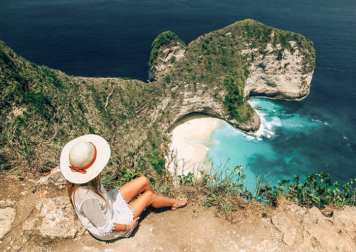
Southern Beaches Area (Coastal Escape)
These southern beaches work best as additions to 10+ day itineraries. If you're doing the classic week-long circuit, Pulau Merah near Banyuwangi is your most accessible beach option.
- Red Island Beach (Pulau Merah): Known for its reddish sand and a small island just offshore, popular with beginner surfers.
- Sukamade Beach (Meru Betiri National Park): Famous as a nesting ground for sea turtles. Requires a rugged journey but offers a unique chance to see turtles laying eggs at night (seasonal).
- Papuma Beach: A beautiful white-sand beach known for its dramatic rock formations just offshore.
Madura Island - The Forgotten Territory
The Suramadu Bridge connects Surabaya to Madura Island, stretching 5.4 kilometers across the Madura Strait—Southeast Asia's longest bridge.
Madura remains largely untouched by tourism, preserving distinct cultural traditions. The island is famous for bull racing (karapan sapi).
East Java's Volcano Trail Map: A Journey to Bromo & Ijen
This is the heart of the East Java adventure for most travelers. This map zooms in on the legendary volcanic duo: Mount Bromo and Ijen Crater. It provides a more detailed look at the geography of these areas and the specific points you'll visit during the classic tours.
Mount Bromo Map
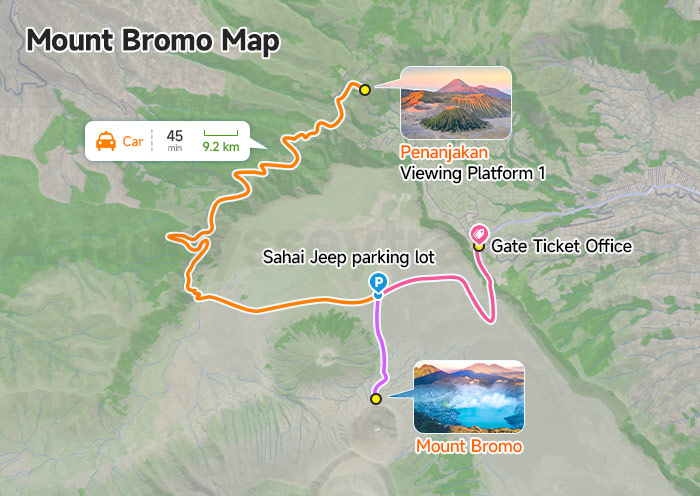
Bromo sits inside a massive volcanic caldera measuring roughly 10 kilometers across. An ancient eruption created this natural amphitheater, leaving four volcanic cones rising from the flat Sea of Sand.
Cemoro Lawang village perches on the northwestern caldera rim. Jeeps depart Cemoro Lawang around 3:30 AM for the 45-minute drive up rough mountain tracks to the most famous sunrise viewpoint, Penanjakan, sits on the caldera rim south of Bromo at 2,770 meters.
Sunrise transforms the scene as light fills the caldera and illuminates Semeru smoking in the distance.
After sunrise, jeeps descend to the Sea of Sand. You'll transfer to the caldera floor and either walk or hire a horse for the 30-minute trek across volcanic sand to Bromo's base.
From there, 250 concrete steps climb to the active crater rim. The sulfur smell intensifies with each step. At the top, peer into the smoking crater while feeling the earth's heat rising from below.
Mount Ijen Map
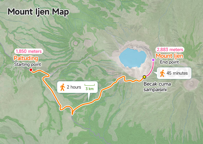
Ijen sits in a different landscape than Bromo. Paltuding at 1,850 meters serves as the trailhead. A sealed road runs from Banyuwangi to this point, taking about 1.5 hours. Most visitors stay in Banyuwangi or nearby homestays and drive to Paltuding around 1:00 AM.
The trail climbs 3 kilometers from Paltuding to the crater rim, gaining roughly 1,000 meters elevation. The first 2 kilometers follow a good path through forest. The final kilometer steepens dramatically, scrambling over loose volcanic rock. Allow 1.5-2 hours going up.
Reaching the rim, you're at 2,883 meters overlooking the turquoise acidic lake far below. The blue fire occurs on the crater's inner slope, requiring a descent down steep, loose terrain for about 45 minutes. Gas masks become essential here as sulfur concentrations spike.
The blue fire only glows visibly in darkness before natural light washes it out. You'll need to reach the crater between 1:00-3:00 AM to see it properly. Most visitors experience the blue fire, then climb back to the rim for sunrise over the crater lake.
East Java Travel Routes - Connecting Major Destinations (Itinerary Map)
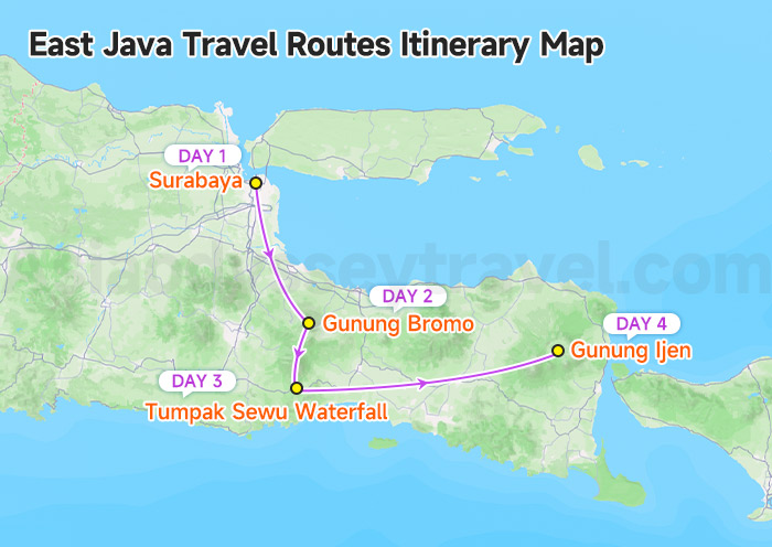
How do you weave these incredible natural wonders into a logical and thrilling adventure? This map illustrates a popular 4-day itinerary that combines the three absolute highlights: Bromo, Tumpak Sewu, and Ijen. It starting from Surabaya and ending near the Bali ferry.
Day 1: Start from Surabaya (pickup by pre-booked car/tour). Drive approx. 3-4 hours directly to your accommodation in Cemoro Lawang. Settle in, enjoy the cool mountain air, and rest early for the sunrise mission.
Day 2: Wake up around 3 AM for the classic Bromo sunrise Jeep tour. Experience the sunrise from Penanjakan Peak, cross the Sea of Sand, and hike up to the Bromo crater rim. After breakfast back in Cemoro Lawang, drive south towards the Tumpak Sewu area (approx. 4-5 hours).
Day 3: Spend the morning doing the adventurous hike down to the base of Tumpak Sewu Waterfall. This involves bamboo ladders and river crossings – an incredible experience. After lunch, begin the long drive east towards the Ijen area (approx. 6-7 hours).
Day 4: Wake up around midnight for the Ijen blue fire hike. Trek up, descend into the crater (with gas mask) to see the blue flames, and witness the sunrise over the turquoise crater lake.
East Java Transportation Map
Let's tackle the practical question: how do you physically move between all these places? This section maps your transportation options from international arrival through local transfers.
Getting To East Java
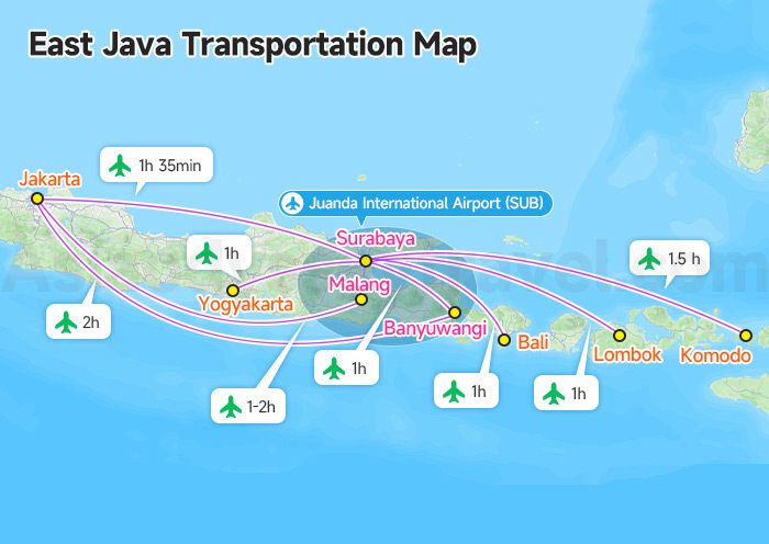
Most international visitors arrive at Juanda International Airport (SUB) in Surabaya.
Smaller airports in Malang (MLG) and Banyuwangi (BWX) serve domestic destinations. Flying into Malang makes sense if Tumpak Sewu is your priority.
Banyuwangi Airport works perfectly for Ijen-focused trips or if you're approaching from Bali by air rather than ferry.
Ferry Connection to Bali
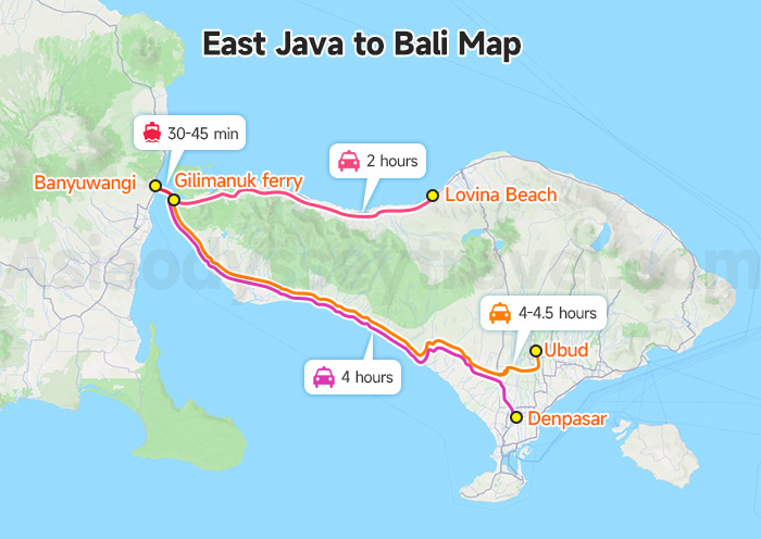
Ketapang ferry port to Gilimanuk ferry: 30-45 min
Gilimanuk to Lovina Beach: 2h car
Gilimanuk to Ubud: 4-4.5 h car
Gilimanuk to Denpasar: 4 h car
The Ketapang ferry port in Banyuwangi connects to Gilimanuk in western Bali via frequent ferries. Service runs 24 hours daily with departures every 15-20 minutes. The crossing takes 30-45 minutes depending on conditions.
Explore Indonesia with Asia Odyssey Travel – Your Trusted Asia Travel Experts
Welcome to Indonesia! Plan your holiday with Asia Odyssey Travel. We are a leading travel company in Asia with over 10 years of experience.
We are experts at organizing trips across Southeast Asia, whether you want a deep tour of Indonesia or a multi-country adventure. With our experience and strong network, we make sure your trip is safe, smooth, and perfectly planned.
Pick Your Perfect Trip Below:
✅ Indonesia Tours: See all our best travel plans for the whole country.
✅ Bali Tours: Our most popular trips to the famous "Island of the Gods."
✅ Departing from Asia & Pacific: › Bali Tours from Singapore › Bali Tours from Malaysia › Bali Tours from Australia › Bali Tours from India › Bali Tours from Philippines › Bali Tours from Nepal
✅ Departing from North America: Bali Tours from USA · Bali Tours from Canada
Contact us today to start planning your Indonesia & Southeast Asia journey!
: Indonesia Map with Cities, Islands & More")


")


")