Hoi An on Vietnam Map: Where Is Hoi An in Vietnam Located?
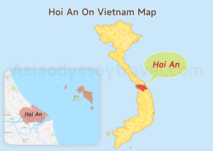
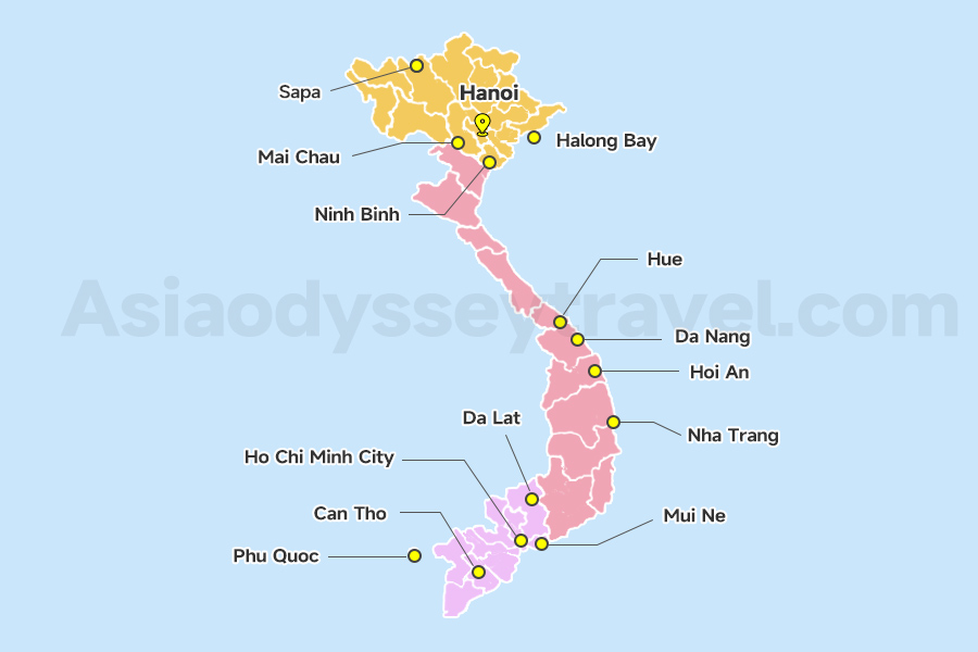
Let me help you locate Hoi An on Vietnam's map. Look at Vietnam's long coastline shaped like an "S". Hoi An sits right in the middle, about halfway between Hanoi and Ho Chi Minh City. It belongs to Quang Nam province, just 30km south of Da Nang (the big city with the airport).
Surrounding Area of Hoi An: Day Trip Option
Da Nang (30 minutes north) has modern vibes and airports. Hue (3 hours north) wows with royal tombs. My Son Sanctuary (1 hour southwest) hides ancient temple ruins in the jungle.
Da Nang Map: Da Nang City Map, Tourist Map (2026)
Hue Vietnam Map: Hue Imperial City Map & Tourist Map
Your Hoi An City Map: A Guide to the Key Areas
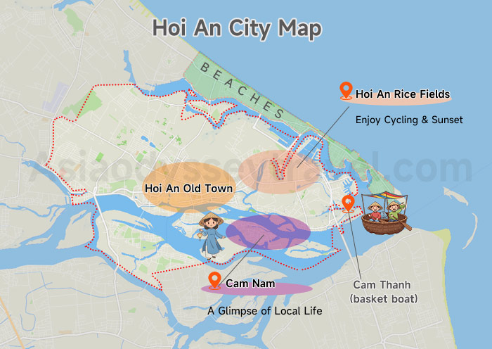
Hoi An hugs the river near the coast, surrounded by green rice fields. With rural landscapes across 9 urban districts and 4 rural communes. The main areas you should know are:
- At its heart lies the Hoi An Ancient Town (UNESCO-list site), with its yellow buildings, lantern-lit streets, and tailors.
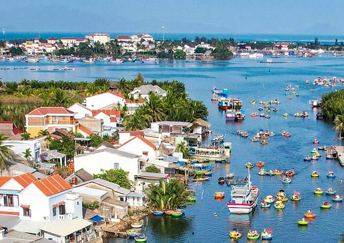
- East (Cam Thanh): You will find Cam Thanh, where the river meets the sea. This is a lush area with coconut palms and basket boat. An Bang and Cua Dai beaches stretch along the coast.
- North: Cycle through endless green rice paddies for beautiful, relaxing views and great photos.
- South (Cam Nam Island): Visit this island to get a glimpse of authentic local life.
- Don't forget the Cham Islands (Cu Lao Cham)—a group of eight islands 15 kilometers offshore. You can see it on front Hoi An Vietnam Map.
Hoi An is small - you can walk across the Old Town in 20 minutes. Most visitors stay near the center or beaches.
Hoi An Tourist Map: Top Hoi An's Attraction on Map
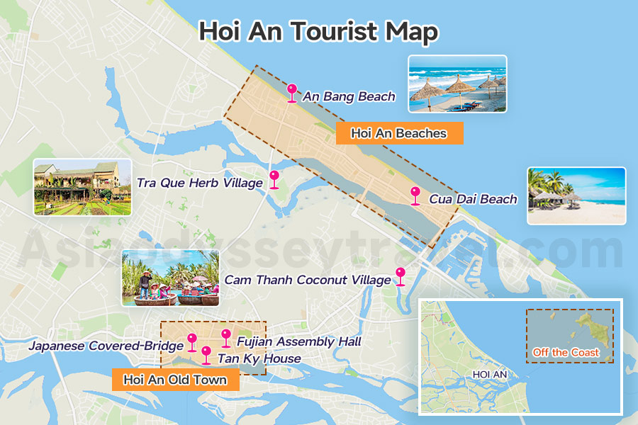
On this tourist map of Hoi An made by Asia Odyssey Travel, you'll find this lovely little town in Central Vietnam. It's full of colorful lanterns, charming streets, and many popular places to visit. Everything (except the beaches and islands) is within walking distance!
Hoi An Old Town (City Center)
This UNESCO World Heritage site is the heart of Hoi An and is clearly marked on the map. Its streets are lined with yellow walls and lanterns.
One must-see is the Japanese Covered Bridge on the west side. Built in the 16th century, it's one of the most famous bridges in Vietnam and appears on many postcards.
The Fujian Assembly Hall in the south-central part was built in the 17th century by Chinese settlers. It's known for its beautiful design. You can also visit old merchant houses like Tan Ky House near the river to see how people lived many years ago.
Hoi An Beaches (East Coast)
Just 4 km east from the old town is An Bang Beach, a relaxing spot with white sand and fishing boats. A bit farther north is Cua Dai Beach. It's still nice, though some of it has been damaged by erosion.
Other Places Around Hoi An
- Cam Thanh Coconut Village (3 km southeast): Paddle bamboo boats through palm forests in this “water coconut jungle.”
- Tra Que Herb Village (2 km northwest): Bike here to see fragrant gardens growing herbs for Hoi An's iconic dishes.
- My Son Sanctuary (40 km southwest): Ancient Hindu temples in the jungle-Vietnam's answer to Angkor Wat.
Off the Coast (East)
Looking east on the map, you'll see 8 islands. These are part of a UNESCO World Heritage area and are great for snorkeling. You can also hike to see the ancient Cham well.
17 Best Things to Do in Vietnam for Best Trip in Vietnam 2026 (with Photos & Tips)
Hoi An Old Town Map: Key Streets & Highlights
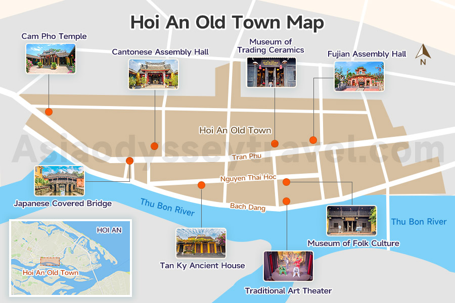
This Hoi An Old Town map shows you the best way to find the highlights of this UNESCO-list site. About 1 square kilometer of magic between Nguyen Thi Minh Khai Street (north) and Nguyen Thai Hoc Street (south). You'll know you've entered when cars disappear, replaced by walking tourists and the occasional bicycle.
With 1,107 buildings (844 are UNESCO-protected!), the Hoi An Old Town feels like stepping into the past. The best spots cluster along 3 main streets:
Tran Phu Street (Main Street)
This is the heart of the Old Town. Start at the Japanese Covered Bridge on the west end. Walk east, and you'll pass the colorful Fujian Assembly Hall with its dragon carvings, the Cantonese Assembly Hall with a stunning mosaic wall, and quiet temples like Cam Pho Temple. Every corner tells a story of traders and traditions.
Nguyen Thai Hoc Street (Museums & Culture)
Running parallel to Tran Phu Street, this road is packed with history. Visit the Tan Ky Ancient House—a 200-year-old home kept perfect by seven generations. Nearby, the Museum of Folk Culture and Museum of Trading Ceramics show how Hoi An became a global trade hub. Don't miss the Traditional Art Theater for live music and dance shows.
Bach Dang Street (Riverside)
This street along the Thu Bon River is perfect for evening walks. Watch boats glide by, or join a boat ride to see the Old Town from the water. If you're lucky, visit during the Full Moon Lantern Festival—the river lights up with floating lanterns and music.
Hoi An Travel Map: Accommodation & Food Area
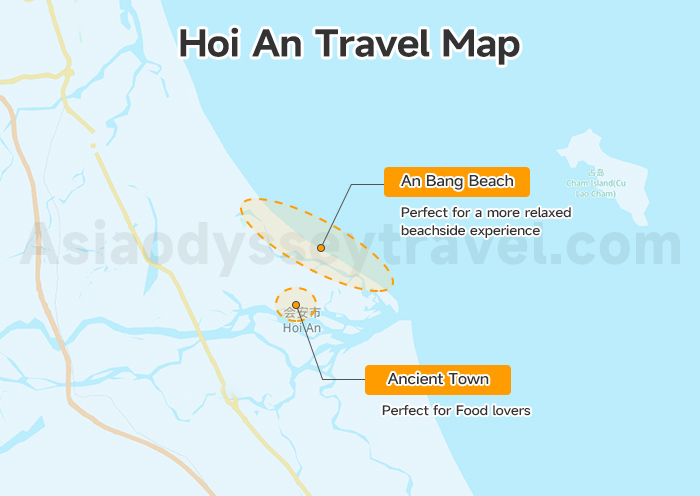
Now that you've explored Hoi An and its Ancient Town through our maps and articles, let's look at our Hoi An Travel Map to understand where to stay and eat.
Find Your Accommodation & Food on Map
For your stay in Hoi An, you have two main areas to choose from. Many visitors prefer staying in or near the Ancient Town, putting them right in the heart of the heritage area. Others choose An Bang Beach, about 4 kilometers east, for a more relaxed beachside experience.
Food lovers will be delighted by the dining options throughout the Ancient Town, especially around the Central Market and along the riverside. The Night Market on An Hoi Islet comes alive in the evening with local specialties.
Best Vietnam Traditional Food: 15 Must-Try Vietnam Dishes
Hoi An Transportation Map: Key Connections & Day Trips
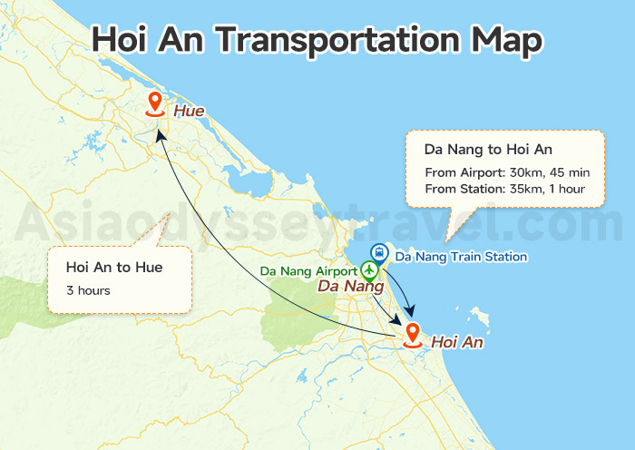
Hoi An has no airport or train station of its own, so most travelers use Da Nang, just 30 kilometers away, as their gateway to Hoi An. Let me show you the key transport connections on our Hoi An transportation map.
Da Nang to Hoi An
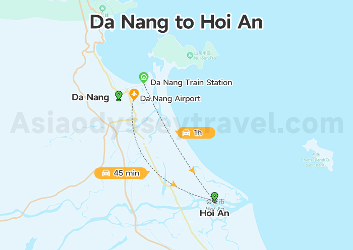
- Da Nang Airport (DAD): 30km north - 45 min by taxi or shuttle bus.
- Da Nang Train Station: 35km north - 1 hour by bus/taxi. Follow Highway 1 south from Da Nang to Hoi An.
Hoi An to Hue
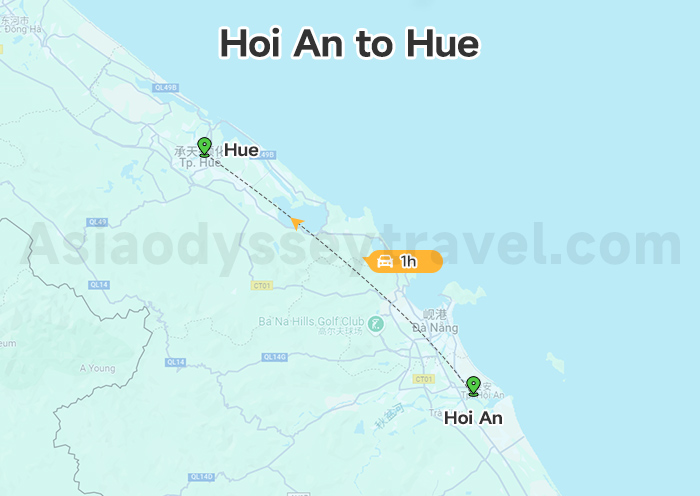
Since many visitors combine their trip with Hue, the former imperial capital, it's worth noting the transport links between these cities.
From Hoi An to Hue, you can take a private car or join a tour bus that travels through the scenic Hai Van Pass. This journey typically takes about 3 hours, though many travelers make a day of it, stopping at landmarks along the way.
Map of Day Trip to My Son Sanctuary & Cham Islands
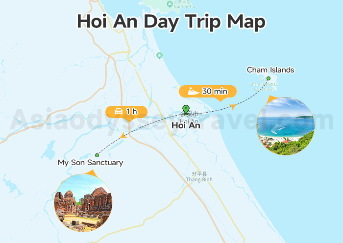
My Son Sanctuary: For day trips, getting to My Son Sanctuary takes about an hour by car, following highway QL14B southwest. Most visitors join morning tours departing from Hoi An's center.
Cham Islands: The Cham Islands are accessible from Cua Dai Harbor, with regular boats making the crossing. Fast boats take 30 minutes, while traditional boats offer a more leisurely 90-minute journey. These boat services operate during the dry season, typically from March to September.
Vietnam Itinerary 2026: 5-14 Days Itineraries in Vietnam
Travel with Asia Odyssey Travel (AOT) to Explore Vietnam
As Asia-based travel experts, Asia Odyssey Travel is here to help you enjoy the best of Vietnam. We create easy, fun, and authentic local tours that take you from the country's classic highlights to its most unique destinations.
Our Vietnam Tours at a Glance:
✅ Vietnam Tours - 10+ Best Tour Packages
✅ Top Vietnam Destinations: Hanoi, Ho Chi Minh City, Hoi An, Halong Bay, Mekong Delta
Helpful Articles for Your Vietnam Trip:
- Vietnam Travel Guide → All you need to know before you go.


")