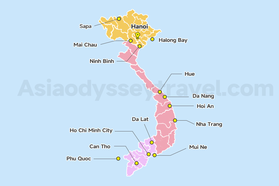
Vietnam Tourist Map Overview: 10+ Essential Maps for Your Journey
| Map Type | Best For | Key Features |
|---|---|---|
| Vietnam Location Map | Overall orientation | Vietnam in World, Asia context |
| Vietnam Map with Cities | Urban & regions navigation | Cities, north,south,central Vietnam map |
| Vietnam Tourist Map | Sightseeing | UNESCO sites, top destinations |
| Vietnam Food Map | Food Lovers | Best food to try in Vietnam |
| Vietnam Airports Map | Flight planning | 11 airports |
| Vietnam Itinerary Map | Itinerary planning | Recommended travel length & routes |
| Vietnam Indochina Map | In-depth exploration | Southeast Asia countries combine trip |
Vietnam Location Map: Where is Vietnam on the World & Asia Map? (For First-Timers)
These 2 Vietnam location maps show where Vietnam is in the world and in Asia. It's a long country on the eastern edge of Southeast Asia, next to China, Laos, and Cambodia.
| Geographic Detail | Information |
|---|---|
| Coordinates | 8° to 23° North latitude, 102° to 115° East longitude |
| Region | Southeast Asia |
| Bordering Countries | China (North), Laos & Cambodia (West) |
| Coastline | South China Sea (East) - 3,260 km |
| Total Area | 331,212 square kilometers |
| Capital | Hanoi (North Vietnam) |
| Largest City | Ho Chi Minh City (South Vietnam) |
| Population | Approximately 98 million (2024) |
Vietnam on World Map: Southeast Asia's S-Shaped Tropical Gem

Vietnam is located in Southeast Asia, shaped like an elongated "S" along the eastern coast of the Indochina Peninsula.
The country stretches about 1,650 kilometers from north to south. On the world map, Vietnam lies between 8° and 24° north latitude, making it a tropical and subtropical country.
Vietnam's unique elongated shape means the three distinct regions with different climates, cultures, and landscapes. Plan accordingly.
Vietnam Map in Asia: Vietnam's Neighbors
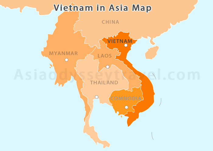
Let me point out Vietnam's neighbors on this map. To the north is China, to the west are Laos and Cambodia. The most striking feature is Vietnam's long eastern coastline along the South China Sea, stretching over 3,260 kilometers. And the Gulf of Thailand touches the southern tip.
Vietnam's Borders:
- North: Borders China (1,450 km land border)
- South: Reaches the Gulf of Thailand (near Ho Chi Minh City)
- East: Faces the South China Sea with stunning beaches (3,260 km coastline)
- West: Touches Laos (2,161 km border) and Cambodia (1,158 km border)
Vietnam Map with Cities: North vs. Central vs. South (Best Spots to Visit)
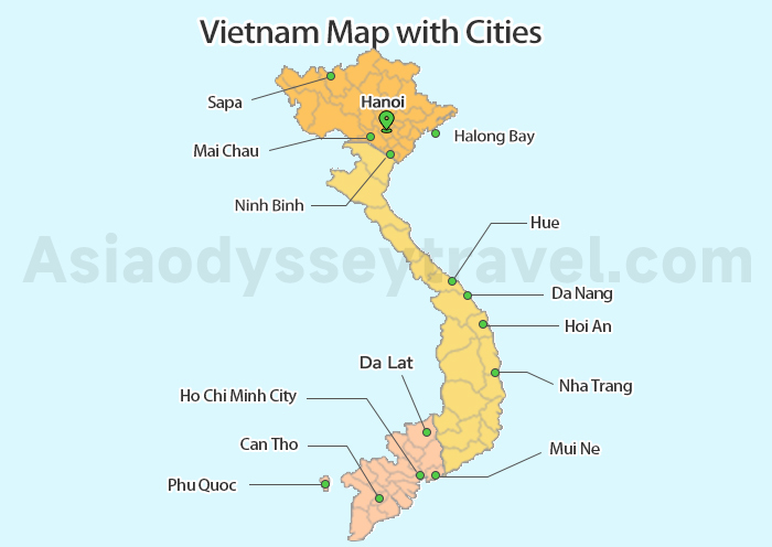
Below are four maps: one showing where the major cities actually are, then zoomed-in views of the North (Hanoi and Ha Long Bay), Central (Hue and Hoi An), and South (Ho Chi Minh City and the Mekong Delta).
Use these to figure out which region matches what you're looking for.
| Region | Key Cities | Best For | Suggested Days | Climate |
|---|---|---|---|---|
| North Vietnam | Hanoi, Ha Long, Sapa | Culture, Nature, Trekking | 5-7 days | 4 seasons, cool winters |
| Central Vietnam | Hue, Hoi An, Da Nang | History, Beaches, Food | 4-5 days | Tropical, avoid Oct-Nov |
| South Vietnam | HCMC, Mekong, Phu Quoc | Cities, Rivers, Islands | 4-5 days | Hot year-round, dry Nov-Apr |
North Vietnam Map: Hanoi, Ha Long Bay & More (20°-24°N)
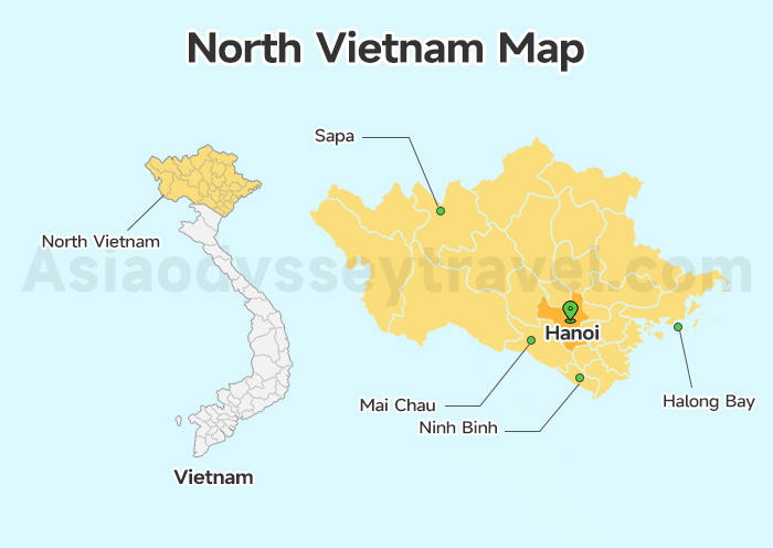
- Cities: Hanoi, Halong Bay, Sapa, Ninh Binh, Mai Chau
- Best Time to Visit: September-December (dry, cool weather 15-25°C)
- Recommended Duration: 5-7 days
This region sits between 20°-24°N latitude, with cool winters and warm summers—making it the most comfortable for outdoor exploration from September to December.
It's where most travelers start exploring Vietnam, with the main international gateway being Hanoi's Noi Bai Airport.
North Vietnam combines limestone mountains, rice terraces, and ancient culture—perfect for first-time travelers looking for a mix of history and nature.
From the North Vietnam map, you can see the following Highlights:
Hanoi: The heart of the north. Experience the Old Quarter, Hoan Kiem Lake, Temple of Literature, and vibrant street food scene.
Halong Bay: A UNESCO site 170 km east of Hanoi. 170km east of Hanoi. UNESCO-recognized bay with 1,969 limestone islands. Take overnight cruises (1-2 nights) for the best experience.
Sapa: Mountainous region near the China border. Explore terraced rice fields, trek through ethnic minority villages.
Ninh Binh: 100 km south of Hanoi. Visit "Halong Bay on land," Tam Coc boat rides, and ancient Hoa Lu temples.
Mai Chau: West of Hanoi. Peaceful valley perfect for cycling, traditional stilt house stays, and Thai cultural experiences.
| Destination | Distance from Hanoi | Time Needed |
|---|---|---|
| Halong Bay | 170 km | 2 days |
| Sapa | 320 km | 3 days |
| Mai Chau | 150 km | 1-2 days |
| Ninh Binh | 100 km | 1-2 days |
Hanoi Map: City Map, Old Quarter Map & Tourist Map
Ha Long Bay Map: Ha Long Bay Cruise Map & Tourist Map
Central Vietnam Map: Da Nang, Hoi An, Hue & More (14°-20°N)
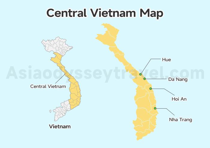
- Key Cities: Da Nang, Hoi An, Hue, Nha Trang, Dalat
- Best Time to Visit: February-May (dry season, 25-30°C); avoid September-December (heavy rain)
- Recommended Duration: 5-7 days
This region sits between 14°-20°N latitude, with dry seasons perfect for beach trips and heritage exploration—ideal for travelers looking to mix culture and relaxation. It represents Vietnam's cultural heartland, connecting North and South Vietnam.
Most visitors arrive via Da Nang International Airport. Central Vietnam offers UNESCO heritage sites, pristine beaches, and imperial history—ideal for culture and beach lovers.
Hue was the imperial capital for over 140 years and still has the citadel and royal tombs to prove it. Hoi An is a perfectly preserved ancient town where cars are banned in the center and lanterns light up every evening. Da Nang offers world-class beaches.
| Route | Distance | Travel Time | Recommended Stay |
|---|---|---|---|
| Da Nang ↔ Hoi An | 30 km | 45 min (taxi/Grab), 1 hour (bus) | Da Nang: 1-2 days, Hoi An: 2-3 days |
| Da Nang ↔ Hue | 100 km | 3 hours (Hai Van Pass), 2.5 hours (tunnel/train) | Hue: 1-2 days |
| Hoi An ↔ Hue | 120 km | 3.5 hours | Allow 4-5 hours with photo stops at Hai Van Pass |
| Da Nang → Nha Trang | 540 km | 1 hour (flight), 8 hours (train) | Nha Trang: 2-3 days (beach + islands) |
| Nha Trang → Dalat | 140 km | 3.5 hours | Dalat: 2 days (mountain town) |
Click and save this Central Vietnam city map for free to map out your heritage and beach itinerary!
Da Nang Map: Da Nang City Map, Tourist Map (2026)
Hue Vietnam Map: Hue Imperial City Map & Tourist Map
Hoi An Maps: Hoi An Old Town Map & Tourist Map
South Vietnam Map: Ho Chi Minh City, Mekong Delta & Phu Quoc (8°-14°N)
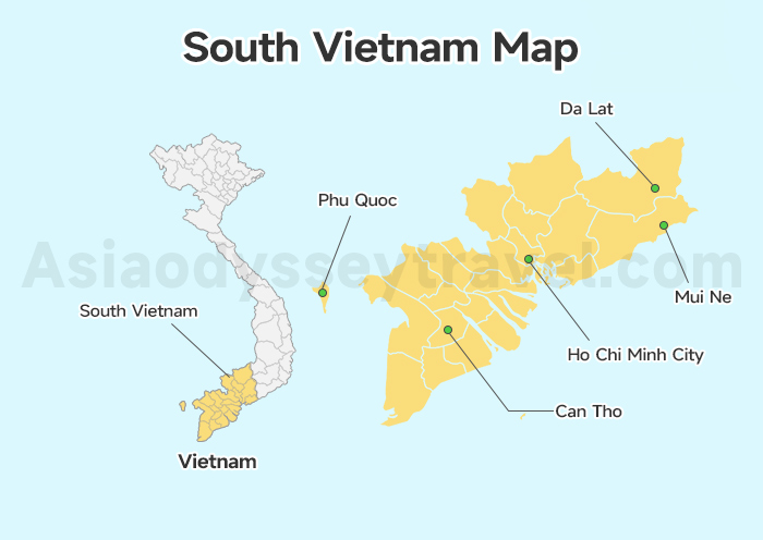
- Key Cities: Ho Chi Minh City (Saigon), Can Tho, Phu Quoc, Mui Ne, Vung Tau
- Best Time to Visit: December-April (dry season, 28-35°C); wet season May-November has brief afternoon rains
- Recommended Duration: 5-7 days
This region sits between 8°-14°N latitude, with tropical weather year-round—dry season (December-April) is the best time to visit for outdoor and beach activities. This map introduces Southern Vietnam, a region of bustling cities, lush deltas, and tropical islands.
Most travelers start in Ho Chi Minh City (HCMC). South Vietnam combines bustling city life, lush Mekong Delta, and beach destinations—perfect for urban explorers and nature lovers.
Ho Chi Minh City (still called "Saigon" by many locals) is a sprawling metropolis with war history museums, rooftop bars, and street food on every corner.
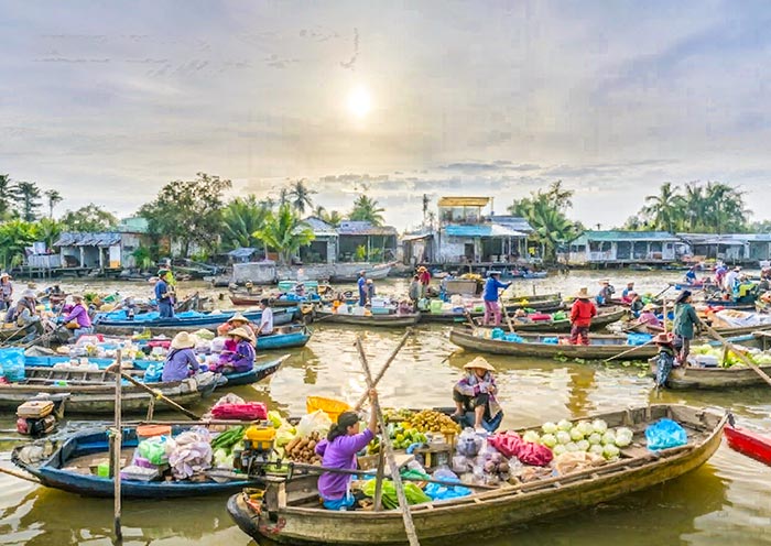
The Mekong Delta offers a glimpse into river life, while Phu Quoc Island provides the beach relaxation you'll crave after weeks of sightseeing.
| Route | Distance | Travel Time |
|---|---|---|
| HCMC → Mekong Delta (My Tho/Ben Tre) | 70-90 km | 2-3 hours |
| HCMC → Can Tho | 170 km | 4 hours (car), 1 hour (flight) |
| HCMC → Phu Quoc | 400 km | 1 hour (flight) |
| HCMC → Mui Ne | 200 km | 4.5 hours |
| HCMC → Vung Tau | 125 km | 2.5 hours (car), 1.5 hours (hydrofoil) |
| HCMC → Con Dao | 230 km (direct flight) | 45 minutes |
Ho Chi Minh City Map 2026: Saigon District, Tourist & Travel Maps
Mekong Delta Maps 2026: Detailed Tourist Map of Mekong Delta & Can Tho
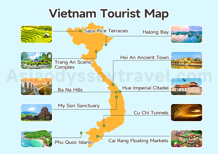
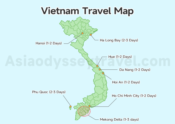
Vietnam Tourist Map with Attractions: 8 UNESCO Sites + 10 Sightseeing You Can't Miss

Having previously explored regional geographies, let's now examine this comprehensive Vietnam tourist map where we've marked all of Vietnam's most popular tourist sites, UNESCO World Heritage locations, and hidden gems.
This visual overview helps you identify must-see attractions from north to south and understand their relative positions for efficient itinerary planning.
9 UNESCO World Heritage Sites Marked on Map
| Site | Type & Year | Location | What Makes It Special |
|---|---|---|---|
| Ha Long Bay | Natural, 1994 | Gulf of Tonkin, 170 km east of Hanoi | 1,600 limestone islands rising from emerald waters. |
| Phong Nha-Ke Bang National Park | Natural, 2003 | Quang Binh Province, 450 km south of Hanoi | World's largest cave (Son Doong: 200m high, fits a 40-story building). |
| Complex of Hue Monuments | Cultural, 1993 | Hue, Central Vietnam | Vietnam's capital 1802-1945. |
| Hoi An Ancient Town | Cultural, 1999 | Hoi An, 30 km south of Da Nang | 15th-19th century trading port with 800+ preserved buildings. |
| My Son Sanctuary | Cultural, 1999 | 40 km southwest of Hoi An | Champa Kingdom Hindu temples (4th-13th century). |
| Citadel of the Ho Dynasty | Cultural, 2011 | Thanh Hoa Province, 150 km south of Hanoi | 14th-century ruins with massive limestone blocks (20 tons each) fitted without mortar. |
| Trang An Scenic Landscape Complex | Mixed, 2014 | Ninh Binh, 100 km south of Hanoi | 2,168-hectare karst landscape + 30,000 years of archaeological sites. |
| Imperial Citadel of Thang Long | Cultural, 2010 | Central Hanoi (Ba Dinh District) | 1,300 years of continuous occupation as Vietnam's political center (7th century onward). |
| Con Son, Kiep Bac | Cultural, 2025 | Quang Ninh, Bac Ninh, and Hai Phong (Northern Vietnam) | Birthplace of the Truc Lam Zen sect (13th century) |
Top 10 Must-See Attractions (Beyond UNESCO Sites)
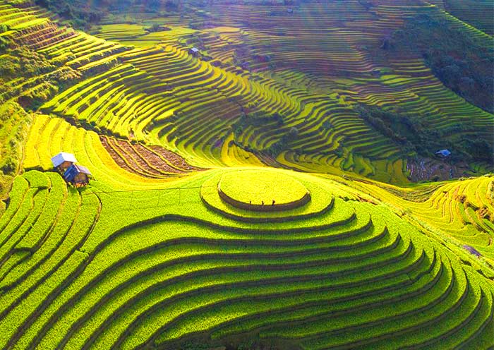
Sapa Rice Terraces: Magnificent step-farming landscapes stretching across mountainsides in Lao Cai Province, best viewed September-October when rice turns golden.
Fansipan Mountain: At 3,143m, Indochina's highest peak offers stunning views.
Ba Be National Park: Vietnam's largest natural lake (500 hectares) surrounded by limestone mountains in Bac Kan Province, 240 km north of Hanoi.
Golden Bridge (Cau Vang) at Ba Na Hills: The Instagram-famous bridge held by two giant stone hands opened in 2018, sitting at 1,400m elevation in the mountains west of Da Nang.
Hai Van Pass: The 21 km mountain pass between Da Nang and Hue climbs to 496m, offering spectacular views where the Truong Son range meets the sea.
Cu Chi Tunnels: Vast network of underground tunnels used during the Vietnam War, now a fascinating historical site.
Cai Rang Floating Markets: Vietnam largest floating markets, a must-visit for authentic delta life.
Phu Quoc Island: White-sand beaches, snorkeling, and Phu Quoc National Park for tropical island exploration.
Cham Islands (Cu Lao Cham): A cluster of eight islands 15 km off Hoi An's coast, designated a UNESCO Biosphere Reserve.
Con Dao National Park & Beaches: Beyond the historical prisons, Con Dao offers some of Vietnam's most pristine beaches and coral reefs. Dam Trau Beach features powdery white sand and turquoise water; Ong Dung Beach offers excellent snorkeling.
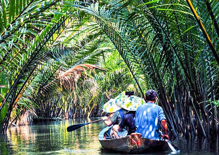
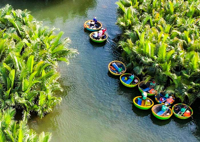
Mekong Delta Canals: Explore narrow waterways by kayak or traditional sampan.
This tourist map of Vietnam is color-coded by attraction type (heritage, other attractions) to help you tailor your itinerary to your travel style.
17 Best Things to Do in Vietnam for Best Trip in Vietnam 2026 (with Photos & Tips)
11 Most Beautiful Places in Vietnam That You Will Never Forget
The Ultimate Vietnam Food Map: Eat Your Way from North to South
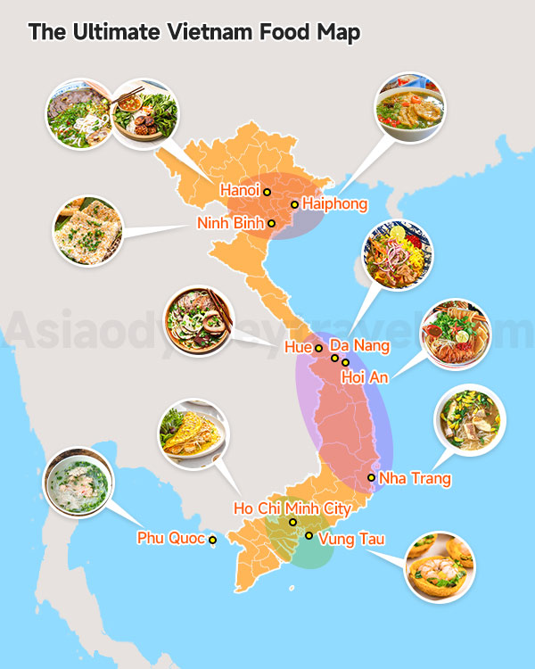
Food is at the heart of Vietnamese travel—and our Vietnam food map is the first of its kind, marking regional street food classics, local restaurants, and food markets from North to South.
- Northern food (Hanoi, Ninh Binh, Haiphong) is subtle and broth-forward.
- Central Vietnam (Hue, Hoi An, Da Nang, Nha Trang) turns up the heat.
- Southern food (Ho Chi Minh City, Mekong Delta) is sweeter and bolder: pho comes with handfuls of herbs.
| Region/City | Signature Dish | Best Spot | Address |
|---|---|---|---|
| Hanoi | Pho (beef noodle soup) | Pho Gia Truyen | 49 Bat Dan St, Old Quarter |
| Hanoi | Bun Cha (grilled pork) | Bun Cha Dac Kim | 1 Hang Manh St, Old Quarter |
| Ninh Binh | Com Chay (burnt rice) | Chookie's Beer Garden | Van Lam Village, Ninh Binh |
| Haiphong | Banh Da Cua (red crab noodles) | Banh Da Cua Hai Phong | 103 Dinh Tien Hoang St |
| Hue | Bun Bo Hue (spicy beef noodles) | Bun Bo Hue O Tuyet | 31A Nguyen Cong Tru St |
| Hoi An | Cao Lau (Hoi An noodles) | Morning Glory | 106 Nguyen Thai Hoc St |
| Da Nang | Mi Quang (turmeric noodles) | Mi Quang 1A | 1A Hai Phong St |
| Nha Trang | Bun Ca (fish noodle soup) | Bun Ca 96A | 96A Nguyen Thien Thuat St |
| Ho Chi Minh City | Banh Xeo (savory pancake) | Banh Xeo 46A | 46A Dinh Cong Trang St |
| Phu Quoc | Bun Quay (hand-pulled noodles) | Bun Quay Kien Xay | 119/8 30 Thang 4 St |
| Vung Tau | Banh Khot (mini savory pancakes) | Banh Khot Co Ba Vung Tau | 11 Hoang Hoa Tham St |
Airports in Vietnam Map: 3 International Gateways & Domestic Flight Network
Here you can see useful Vietnam airports map to help you fly to and around Vietnam—our Vietnam airports map is the ultimate guide for planning your air travel, with all international and domestic flight links marked for easy route building.
One map shows you how to get to Vietnam from other countries, with all the flight paths coming into Vietnam's biggest airports.
The other map helps you move around inside Vietnam, showing how all the cities connect by air—saving you time and hassle on internal travel.
3 Main International Gateway: Hanoi, Ho Chi Minh City & Da Nang
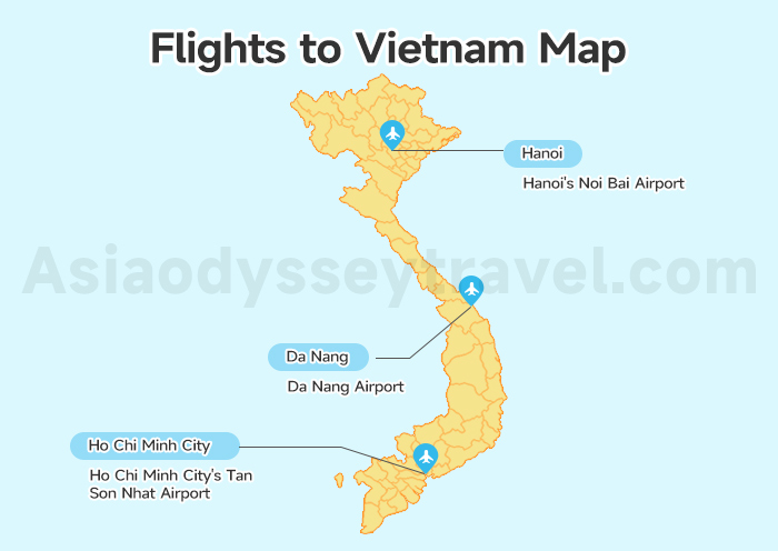
Vietnam has 3 main big airports for international flights. In the north, you'll fly into Hanoi's Noi Bai Airport. Most flights here come from East Asia like Tokyo and Seoul, and some from Europe and Australia.
In the middle of Vietnam, Da Nang Airport welcomes planes mostly from nearby Asian countries.
In the south, Ho Chi Minh City's Tan Son Nhat Airport is the busiest, with flights from all over the world, including Australia, Europe and America—making it the top gateway for western travelers.
Domestic Airports in Vietnam: How to Travel Around Vietnam
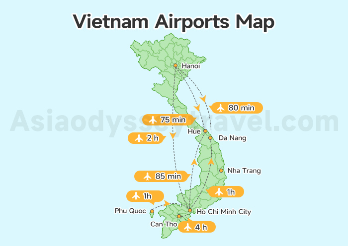
Inside Vietnam, you can fly between many cities. The main route goes between Hanoi and Ho Chi Minh City, taking about two hours.
There are also airports near famous places like Halong Bay, Hue, Nha Trang, and Phu Quoc Island. These smaller airports make it easy to move around the country quickly.
| Airport Name | City | Code | Flight Time from Hanoi |
|---|---|---|---|
| Noi Bai International | Hanoi | HAN | / |
| Tan Son Nhat International | Ho Chi Minh City | SGN | 2H10M |
| Da Nang International | Da Nang | DAD | 1H25M |
| Cam Ranh International | Nha Trang | CXR | 2H |
| Phu Quoc International | Phu Quoc | PQC | 2H10M |
| Cat Bi International | Haiphong | HPH | / |
| Noi Bai International Airport | Hue | HUI | 1H15M |
| Can Tho International | Can Tho | VCA | 2H15M |
Vietnam Travel Map: Perfect Itineraries for 5, 8 & 10 Days
Let me share these 4o helpful travel maps of Vietnam—our Vietnam travel map and 3 Vietnam tour map are designed to turn your planning into action, with pre-built itineraries and travel length guides for every type of traveler.
Our travel length map breaks down the perfect number of days to spend in each city and region, based on first-time traveler feedback and on-the-ground experience.
Vietnam Itinerary 2026: 5-14 Days Itineraries in Vietnam
How to Spend 10 Days in Vietnam: 3 Best Itineraries for Vietnam
Vietnam Itinerary 7 Days: 5 Itinerary Ideas for 1 Week in Vietnam
Vietnam 5-day Itinerary Map: How to See the Best of North Vietnam Quickly
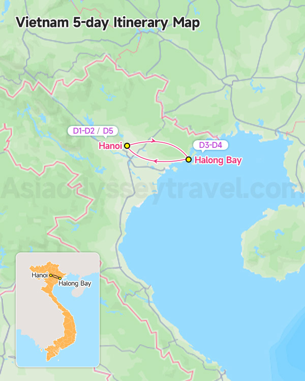
Day 1: Hanoi Arrival, Vietnam
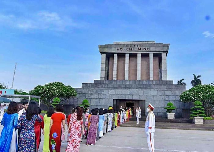
Day 2: Hanoi City Tour (Ho Chi Minh Mausoleum, One Pillar Pagoda, Hoan Kiem Lake & Old Quarter)
Day 3: Hanoi to Halong Bay Tour (Halong Bay Cruise)
Day 4: Halong Bay - Hanoi (Free Time in Hanoi)
Day 5: Hanoi Departure

5 Days Hanoi & Halong Bay Tour: Karst Landscape, Amazing Cruise & Capital City
Hanoi - Halong Bay - Hanoi
Vietnam 8-day Itinerary Map: Classic Route
Our 8-day classic itinerary map is the most popular for first-time visitors, with a seamless route that covers Vietnam's top highlights across the north and south.
| Day | Destination | Attraction & Details |
|---|---|---|
| 1 | Hanoi | Hanoi Arrival |
| 2 | Hanoi City Tour | Ho Chi Minh Mausoleum, One Pillar Pagoda, Hoan Kiem Lake & Old Quarter |
| 3 | Hanoi to Halong Bay | Halong Bay Cruise |
| 4 | Hanoi to Hoi An | Transfer |
| 5 | Hoi An Highlights | Cam Thanh Coconut Basket Boat Trip, Hoi An Ancient Town |
| 6 | Hoi An to Ho Chi Minh City | Half-day Tour in Ho Chi Minh City |
| 7 | Mekong Delta | Mekong Delta Cruise |
| 8 | Ho Chi Minh City | Departure |
8 Days Classic Vietnam Tour (Hanoi, Halong Bay, Hoi An & Mekong Delta)
Hanoi - Halong Bay - Hanoi - Da Nang - Hoi An - Ho Chi Minh City - Mekong Delta - Ho Chi Minh City
Vietnam 10-day Itinerary Map: The Perfect North-to-South Route
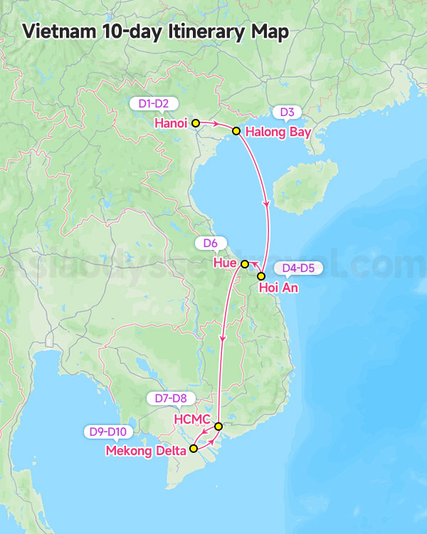
Route: Hanoi → Halong Bay → Da Nang → Hoi An → Hue → HCMC → Mekong Delta → HCMC
This route is best for Travelers who want a comprehensive Vietnam experience (no missed highlights!).
Day 1-2: Hanoi City Tour (Ho Chi Minh Mausoleum, One Pillar Pagoda, Hoan Kiem Lake & Old Quarter)
Day 3: Halong Bay Cruise
Day 4: Hanoi to Hoi An
Day 5: Hoi An Highlights Tour (Cam Thanh Coconut Basket Boat Trip, Hoi An Ancient Town)
Day 6: Hoi An - Hue (Hai Van Pass Tunnel, Hue Imperial City, Mausoleum of Emperor Khai Dinh, Thien Mu Pagoda)
Day 7-8: Ho Chi Minh City Tour (Cu Chi Tunnels, Reunification Palace, War Remnants Museum, Central Post Office)
Day 9-10: Mekong Delta Cruise

10 Days Best Vietnam Tour: Karst Landscape, History, Food & Local Life
Hanoi - Halong Bay - Hanoi - Hue - Da Nang - Hoi An - Ho Chi Minh City - Mekong Delta - Ho Chi Minh City
Extend to 18-21 days and add Phu Quoc Island (3-4 days) for beach relaxation at the end.
Vietnam and Surrounding Countries Map: The Ultimate Indochina Loop
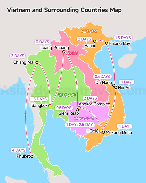
Vietnam is the perfect hub for an Indochina trip—and our Vietnam & Indochina map marks a 21-day cross-border itinerary loop (Vietnam → Laos → Cambodia). This map is a hit for travelers who want to explore more of Southeast Asia.
21-day Indochina Itinerary Ideas (Vietnam as the Hub)
Vietnam (7 days): Hanoi (2 days) - Halong Bay (1.5 days) - Da Nang (0.5 days) - Hoi An (1 day) - HCMC (1 day) - Mekong Delta (1 day) - HCMC (2.5 day)
Cambodia (6 days): Angkor Complex (2 days) - Siem Reap (0.5 day) - Luang Prabang (3 days)
Thailand (8 days): Bangkok (1.5 days) - Chiang Mai (2 days) - Phuket (4 days)
Travel with Asia Odyssey Travel (AOT) to Explore Vietnam
As Asia-based travel experts with 15+ years of experience, Asia Odyssey Travel specializes in personalized Vietnam experiences beyond standard tourist circuits.
Our Services:
✅️ 10+ Vietnam tour packages covering highlights and hidden gems
✅️ All major destinations: Hanoi, HCMC, Hoi An, Halong Bay, Mekong Delta, Hue, Da Nang, Sapa, Phu Quoc
✅️ Specialized tours: Family tours, food tours, photography tours, off-beaten-path adventures


")