Ashgabat Location Map: Where Is Ashgabat Located in Turkmenistan?
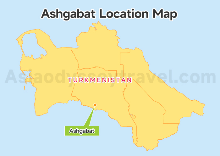
Where is Ashgabat located? Take a look at the Ashgabat Location Map. You'll see the Ashgabat is tucked right into the southern edge of Turkmenistan.
It sits in a lush oasis, squeezed between the rugged Kopet Dag mountains to the south and the vast, golden sands of the Karakum Desert to the north.
It's just about 30 km from the Iranian border. This unique position makes it a bridge connecting the desert heart of Central Asia to the ancient routes of the Middle East.
Ashgabat City Map: 4 Districts & 4 Transport Hubs

Now, let's zoom in to the Ashgabat City Map, a navigator for the "White Marble City." We've designed it to show you the 4 main districts and the best ways to get around.
While your guide is always there for the big trips in Turkmenistan, Ashgabat is surprisingly friendly for solo wandering. Use the map to find your way during "free time" in the center.
The 4 Districts of Ashgabat:
| District (Etraby) | The Vibe | What's Inside? |
|---|---|---|
| Berkararlyk | Active & Local | Teke Bazaar, Gulistan, Ashgabat Railway Station, Museum of Fine Arts. |
| Bagtyyarlyk | The Grand Gateway | Ashgabat Airport, Ashgabat Botanical Garden. |
| Kopetdag | Marble & Monuments | Independence Square, National Museum, Olympic Village. |
| Büzmeýin | Quiet & Residential | Local neighborhood markets and residential life. |
The 4 Major Transport Hubs:
Our Ashgabat City Map pins the vital spots that keep you moving. Whether you're flying in or catching a desert bus, these are the names to know:
- Ashgabat International Airport: Your stunning, falcon-shaped welcome to the country.
- Ashgabat Railway Station: The hub for cozy overnight trains to the Caspian Sea.
- International Passenger Bus Terminal: Where you'll find buses heading north to the "Door to Hell."
- Teke Bazaar Hub: The heart of the city's bus network and a great place for snacks.
Ashgabat Map with Tourist Attractions: Top 10 Must-Sees
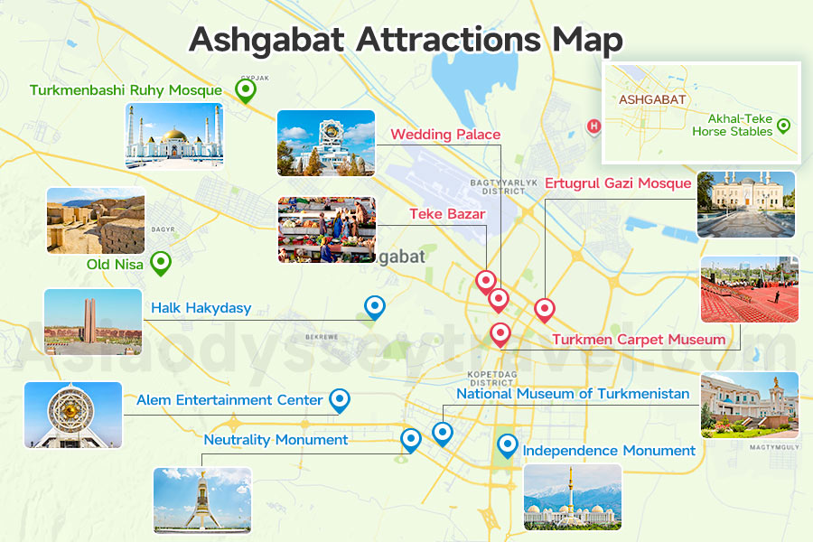
Every landmark you'll want to see is clearly spotted on this Ashgabat Map. To make your sightseeing easy, we've grouped the city's record-breakers and historic gems into THREE main neighborhoods.
The Ashgabat City Center (Culture & Bazaars)
Where grand marble meets the warm pulse of local life.
Ertugrul Gazi Mosque: An Ottoman-style masterpiece with four soaring minarets and a peaceful courtyard, modeled after Istanbul's Blue Mosque.
Teke Bazaar: The most authentic spot on your map of Ashgabat to taste dograma (a traditional meat and bread dish) and shop for hand-embroidered silks.
Turkmen Carpet Museum: Home to the largest hand-woven carpet on Earth, covering over 300 square meters. It is a true masterpiece of patience and art.
The Southern Marble Zone (Modern Record-Breakers)
This is the heart of "New Ashgabat," where the architecture reaches for the sky.
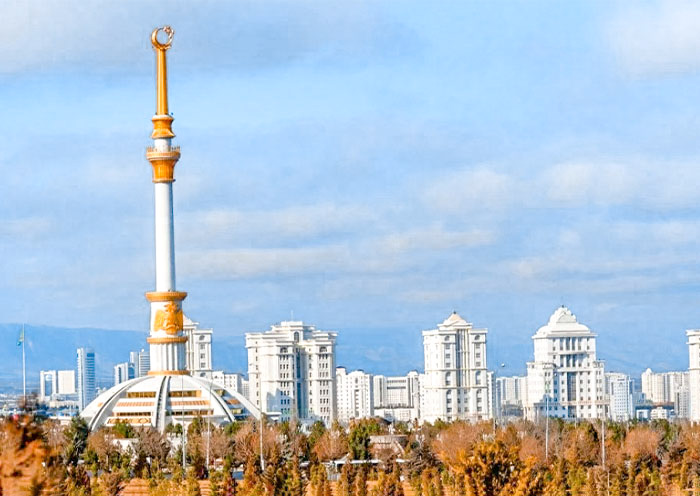
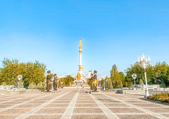
Independence Monument: A 118-meter column inspired by traditional Turkmen tents. It is surrounded by 27 statues of historical heroes and a golden statue of the first president.
Neutrality Monument: Known as "The Tripod," this 95-meter arch features a panoramic viewing deck and a brand-new circular architectural complex opened for its 30th anniversary in 2026.
National Museum of Turkmenistan: A massive complex housing over 500,000 artifacts, including rare ivory rhytons from ancient Nisa and a collection of giant Turkmen gems.
Alem Entertainment Center: This geometric beauty houses the World's Largest Indoor Ferris Wheel. It's fully enclosed, so you can enjoy the view in air-conditioned comfort!
The Wedding Palace (Bagt Koshgi): Perched on a hill, this star-shaped palace is topped with a giant golden globe showing a map of Turkmenistan. It offers the best sunset views in the city.
Halk Hakydasy (People's Memory): A moving memorial complex with a "Museum of the Earthquake" that tells the story of the city's 1948 rebirth.
The Historic Outskirts (Local Heritage)
Old Nisa: Step back 2,000 years at this UNESCO site! These ancient mud-brick ruins were once a royal Parthian capital, offering a dusty, beautiful window into Turkmenistan's deep Silk Road history.
Akhal-Teke Horse Stables: Meet our "heavenly horses"! These legendary creatures are famous for their shimmering, metallic coats. Visiting the stables lets you get up close to a living symbol of Turkmen pride!
Turkmenbashi Ruhy Mosque: This marble giant is Central Asia's largest mosque. Its massive golden dome and towering minarets are breathtaking, especially at sunset when the whole complex glows against the desert sky.
Ashgabat Map with Travel Routes: A Day Trip & A 5-Day Turkmenistan Tour
To help you get the most out of your time, we've created 3 maps of Ashgabat with itinerary routes.
Whether you have a single day or a full week, these routes ensure you don't miss the "marble" magic or the desert's fire.
Ashgabat City Sightseeing Route 1
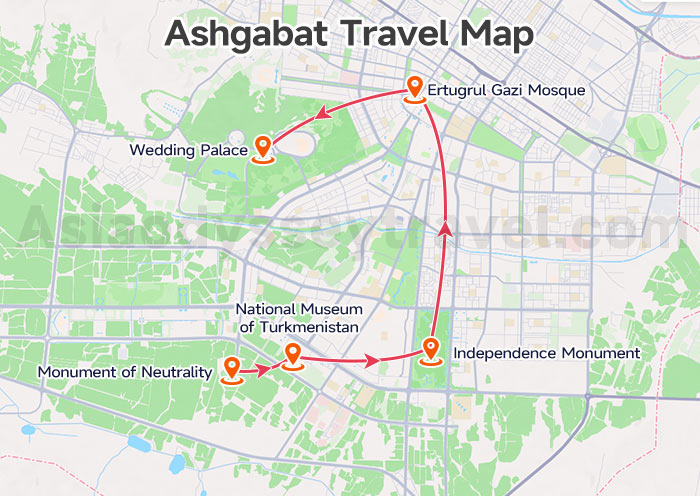
The Ashgabat Sightseeing Route 1 is a smooth loop through Ashgabat's grandest monuments.
It follows this path: Neutrality Monument – National Museum of Turkmenistan – Independence Monument – Ertugrul Gazi Mosque – Wedding Palace.
While these sights are majestic by day, the city truly comes alive as the sun sets! As evening falls, the white marble begins to glow with thousands of multicolored LED lights, turning the streets into a futuristic wonderland.
For the best night view, head to the hilltop Wedding Palace (Bagt Koshgi). From the top, you can see the entire "White City" twinkling in neon rainbows.
Ashgabat City Sightseeing Route 2
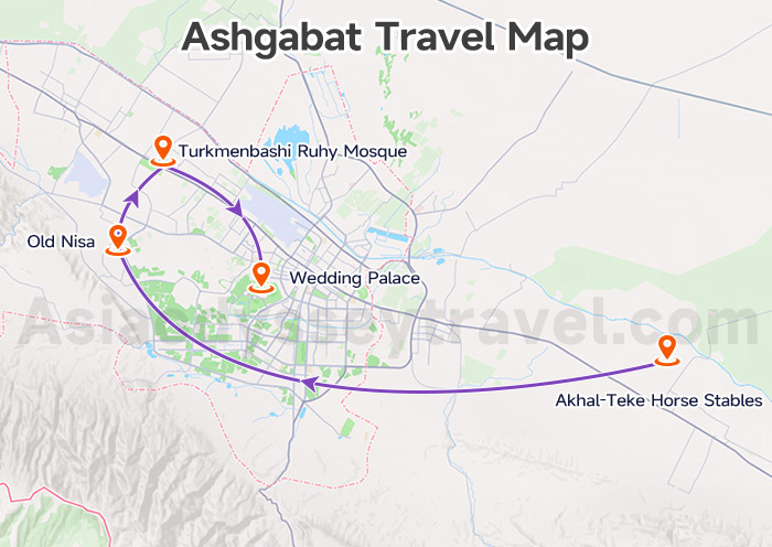
But if you want to dig a little deeper, you can branch off onto Route 2 to see the soul of the country.
This path takes you from the city's outskirts back to its glowing heart: Akhal-Teke Horse Stables – Old Nisa – Turkmenbashi Ruhy Mosque – Wedding Palace (Night View).
On this trip, we'll meet the legendary Akhal-Teke horses before wandering the ancient mud-brick ruins of Old Nisa. As evening falls, we'll visit the massive golden domes of the Ruhy Mosque and finish at the Wedding Palace.
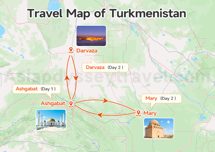
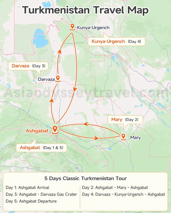
A 5 Days Turkmenistan Adventure from Ashgabat
Why stop at Ashgabat? It took a lot of effort to enter this country—from your Turkmen Visa to the long desert journey—so you should definitely see the legendary "Door to Hell" while you're here!
This Turkmenistan Travel Map tracks a classic 5-day loop:
| Day | Where to Go | What to Do |
|---|---|---|
| 1 | Ashgabat Arrival | We'll meet you at the airport and get you settled into your hotel. |
| 2 | Mary & Ancient Merv | A quick flight takes you to the ruins of a city that was once the largest in the world. |
| 3 | The "Door to Hell" | Sightsee in Ashgabat, then drive into the desert to camp by the glowing Darvaza Gas Crater. |
| 4 | Kunya-Urgench | Head north to see ancient minarets before flying back to the capital. |
| 5 | Ashgabat Departure | A final breakfast and a smooth ride to the airport. |
Getting Around: Transportation Routes on Ashgabat Map
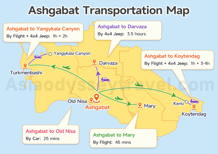
Ashgabat is the "center of the wheel." This Ashgabat Map with Transport Routes gives you a clear overview of how we get from the "White Marble City" to our favorite spots:
| Route | Transport Mode | Time (Approx.) | Distance |
|---|---|---|---|
| Ashgabat to Old Nisa | Car | 25 mins | 15 km |
| Ashgabat to Mary | Flight | 45m | 350 km |
| Ashgabat to Darvaza | 4x4 Jeep (Required) | 3.5 hours | 260 km |
| Ashgabat to Yangykala Canyon | Flight + 4x4 Jeep | 1h (Flight) + 2h (Drive) | 580 km |
| Ashgabat to Koytendag (via Kerki) | Flight + 4x4 Jeep | 1h (Flight) + 3-4h (Drive) | 800 km |
Ashgabat to Old Nisa
Getting to the ancient Parthian capital is a breeze.
It's a smooth 18 km drive from the city center toward the foothills of the mountains, taking only 25 minutes. It's the perfect half-day trip to take during your "free time" in the capital.
Ashgabat to Mary
To save a 5-hour drive across the desert, we highly recommend the 40-minute flight covering the 310 km distance.
Turkmenistan Airlines operates two daily flights between the capital and Mary (one morning and one evening). It's affordable, comfortable, and gives you much more time to explore the ruins of Merv.
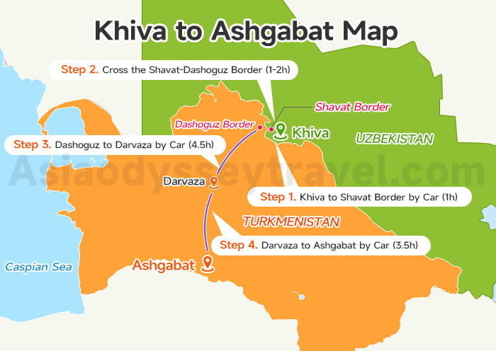
Ashgabat to Darvaza Gas Crater
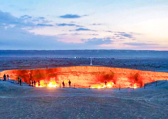
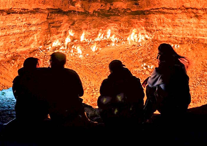
Heading north to the Darvaza Gas Crater covers another 270 km and takes roughly 4 hours.
This stretch is famous for 1 other collapsed gas craters right off the main road: the Darvaza Mud Crater (filled with bubbling grey mud) and the Darvaza Water Crater (a striking turquoise sinkhole).
We usually stop at both for photos before the marble skyline of Ashgabat appears.
Ashgabat to Turkmenbashi & Yangykala Canyon
Turkmenbashi is our gateway to the Caspian Sea. While the train is a long, 14-hour journey, a 1-hour flight to Turkmenbashi is much faster.
From there, you will need a 4x4 to drive north to Yangykala Canyon. This takes 2 hours. Those pink and orange cliffs are hidden deep in the desert, so a good driver is a must!
Ashgabat to Koytendag (Via Kerki)
This is the longest journey, but it's a true adventure. We usually fly for 1 hour to the eastern city of Kerki first.
After that, it is a 3-4h drive by 4x4 toward the mountains. It is a big travel day, but seeing the Dinosaur Plateau makes every kilometer worth it!
Ashgabat Agreement Map: Your Gateway to the New Silk Road
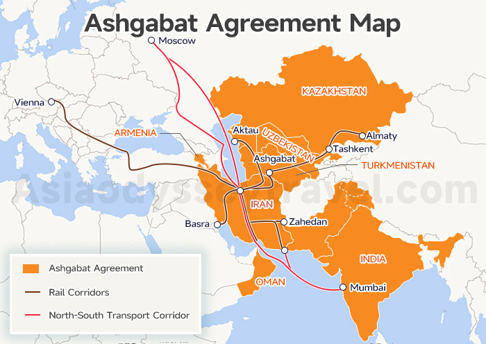
While our other Ashgabat maps focus on the marble streets and desert dunes of Turkmenistan, the Ashgabat Agreement Map zooms out to show you the big picture.
It shows a giant network of trains, roads, and ships—a multimodal corridor—that links Central Asia directly to the warm waters of the Persian Gulf.
What is the Ashgabat Agreement?
Simply put, it's the "New Silk Road." It's a friendly pact between neighboring countries to fix up their roads and rails and make crossing borders a breeze.
The goal is to make travel—for both goods and people—faster and much smoother between the north and the south.
The Member Countries
As of 2026, this "New Silk Road" family has grown! What started with Turkmenistan, Uzbekistan, Iran, and Oman now includes:
- Kazakhstan (joining in 2015)
- Pakistan (joining in 2016)
- India (joining in 2018)
- Armenia (officially joined in 2025!)
The Routes for Planning Your Journey
You can use these corridors to plan an epic, multi-country trip. Here are the main paths the Ashgabat Agreement makes easier:
The Central Route: Travel from Uzbekistan through the heart of Turkmenistan (Ashgabat) and down into Iran. It's the shortest way to reach the Persian Gulf!
The Northern Link: High-speed rail and roads now connect Kazakhstan through Turkmenistan to Iran's Bandar Abbas Port.
The Sea Connection: The route continues across the water to Oman and over to India, making it a truly global adventure.
The Western Gateway: With Armenia now on board, new paths are opening toward the Caucasus, letting you plan a route from the Silk Road all the way toward Europe.
Explore Ashgabat on Map with Asia Odyssey Travel
Ashgabat is a marble wonder, but since you can't travel outside the capital without a licensed guide, Asia Odyssey Travel is here to make your journey easy!
Whether you're looking for budget-friendly Turkmenistan Group Tours or a custom experience with Private Turkmenistan Tours, we have the perfect ride—from comfy 4x4 Mitsubishis to 22-seat buses.
From our popular Ashgabat Tours to overnight Darvaza Gas Crater Tours, we handle everything.
Our guides don't just drive; they even manage those confusing "No-Man's Land" border shuttles for you. Let us handle the logistics while you enjoy the magic of the Silk Road!
Ready to start your adventure? Let's chat—we can't wait to help you plan your perfect Turkmenistan getaway!
")


")


 with Map (2026)")


")
: Tourist Regions, Cities & Surrounding Countries")
 | 2026")