Astana Kazakhstan Map: Where is Astana Located?
Astana coordinates: 51.1605° N, 71.4704° E
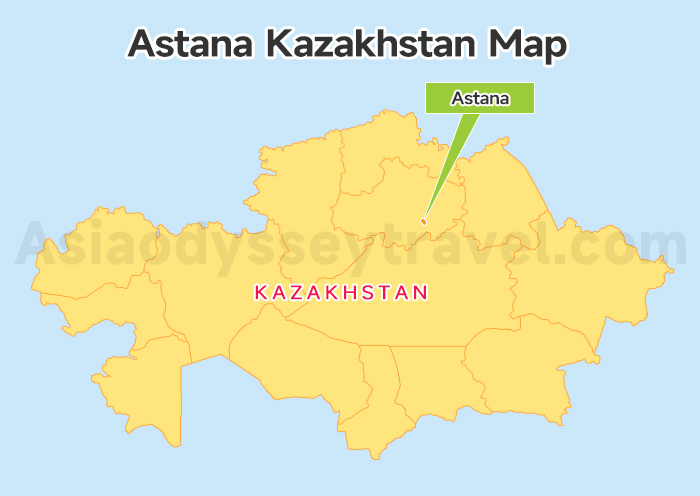
Take a look at the Astana Kazakhstan Map. You will find Astana sitting right in the north-central part of Kazakhstan, flowing along the Ishim River.
And it is about 1,200 km (750 miles) distance from the old capital, Almaty. While Almaty is tucked away near the southern mountains, Astana sits boldly in the middle of the vast, flat steppe.
Its latitude is 51° North, similar to London. But because it is in the open plains, it is famous for being the second-coldest capital in the world.
You might wonder why the capital is here. It was a strategic move in 1997. The government moved the capital from Almaty to this central location to be further from the borders and safe from earthquakes.
Today, fueled by its status as the new administrative center, this location has transformed into a vital transport hub connecting Europe and Asia.
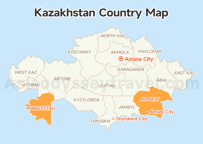
Kazakhstan Map 2026: Map of Kazakhstan Country, Cities, Tourist (Free View)
Astana on Map (City Layout): Left Bank vs. Right Bank
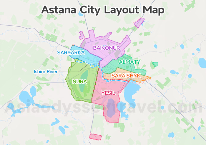
Now that you know where the city sits in the country, let's zoom in closer. When you look at Astana on map, the first thing you will see is the Ishim River. It cuts the city right in the middle. It divides the city into two totally different sides: the Left Bank and the Right Bank.
A Quick Note on the Map: Be careful if you search for maps online. Most of them are outdated and only show 5 districts. Our map below is the latest version, showing the new 6-district layout of the city.
But don't worry about memorizing all the new district names. To plan your trip, you just need to know which side of the river you are on.
The Left Bank (Yesil and Nura districts): The "Tourist Hub"
Look at the left part (Yesil and Nura districts). This is where you will likely spend 90% of your time.
Why? Because almost every famous landmark—from the Bayterek Tower to the Khan Shatyr tent—is concentrated here in the Yesil District. If you want to be close to the main attractions, this is the area you need to focus on.
The Right Bank: (Almaty, Saryarka, Baikonur, and Saraishyk Districts)
While the left is for sightseeing, this is where the city actually lives. You will find the best local restaurants, cheaper markets, and the old train station here. It is the perfect place to explore if you want to see the real, everyday life of Astana beyond the postcards.
Astana City Map: Airport, Railway Station & Accommodation
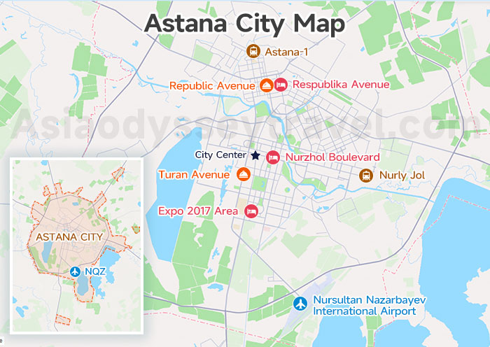
Our Astana City Map below is designed to solve the three biggest questions for any visitor: arrival points, the best sleeping zones, and where to find the best local food.
First, let's find the heart of Astana on the map: the Left Bank. Focus on the area around Independence Square and Nurzhol Boulevard.
Getting In: Airport & Trains
If you are flying in, you are in luck. The Nursultan Nazarbayev International Airport (NQZ) is located at the southern tip of our map.
Unlike many capitals, the airport is surprisingly close—just a 20-minute drive straight up the main avenue to the Left Bank hotel zone.
The Railway Stations (Don't mix them up!) This is a common mistake for travelers. As shown on the map, Astana has two main stations on the Right Bank:
- Nurly Jol (The New Station): Located on the east side. Most travelers taking the high-speed Talgo will arrive and departure here. It's modern and about a 20-minute taxi ride to the center.
- Astana-1 (The Old Station): Located on the north side. This usually serves slower, regional trains. It is much further away (30-40 minutes) from the tourist hub.
Pro Tip: Always double-check your ticket code to see which dot on the map you need to head to!
Where to Stay in Astana? 3 Key Areas!
When pinning down your accommodation, don't just search "Astana." We recommend focusing on three specific circles on the map:
Zone A: Nurzhol Boulevard (Central Left Bank). It is ideal for first-timers, placing you within walking distance of Bayterek Tower, Khan Shatyr, and major attractions.
- The area boasts the newest hotels, from international chains like Ritz-Carlton and St. Regis to boutique options, plus excellent restaurants and modern infrastructure. The downside? It's pricier than other areas.
Zone B: Expo 2017 Area (Southern Left Bank). It Is best for business travelers & Quiet seekers. Located near the Mega Silk Way mall. It offers brand-new international hotels and is closer to the airport, though you will need a taxi to get to the Bayterek area.
Zone C: Republic Avenue (Right Bank). It offers a glimpse into Astana's Soviet past and local life. It is ideal for budget travelers and culture seekers wanting an authentic experience.
- Significantly more affordable, it features budget stays, the Central Market (Zeleny Bazaar), and authentic dining. Enjoy river walks just a 15-20 minute ride from major sites.
Food Guide: The "Tasty" Streets
Where should you eat? The map shows two distinct "food arteries." If you are craving a fancy dinner or international cuisine, head to Turan Avenue on the Left Bank—it's lined with massive, high-end restaurants.
But for everyday eats, I recommend crossing to Republic Avenue on the Right Bank. This is where you'll find the hidden gems, fast food joints, and local canteens where the real city eats.
Astana Tourist Map: The "Millennium Axis" Attractions
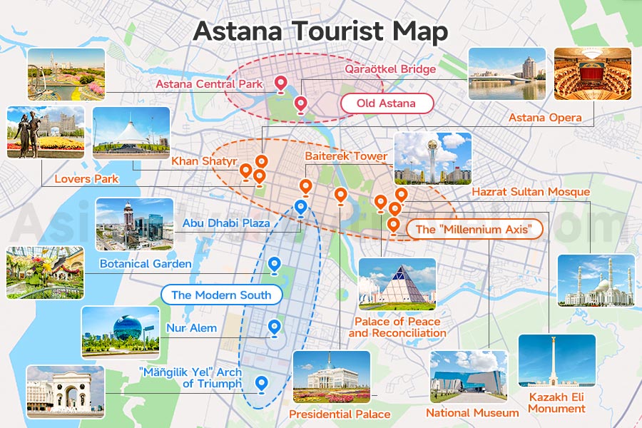
Let's open the most exciting part of our guide: Astana Tourist Map. Astana is famous for its "Sci-Fi" vibe. The city was built to impress, filled with strange and beautiful shapes designed by world-famous architects.
To see it all properly, you should plan for 2 full days. We have divided the map into 3 key zones to help you organize your City Walk.
The "Millennium Axis" (The Must-Do Day)
This is the most important line on the map. It stretches from the Khan Shatyr tent in the west, across the river, to the National Museum in the east. It is a long route, but it connects all the city's "Name Cards."
From the Tent to the Pyramid, you are looking at a solid 4.2-kilometer (2.6-mile) urban hike. If you just speed-walked without stopping, it would take you about an hour. But for travelers, take at least 4-5 hours.
Khan Shatyr: It’s a mall and the World's Largest Tent, designed by the legendary Norman Foster. Even when it is -30°C outside, the top floor features a beach with real sand imported from the Maldives and a constant 35°C tropical climate.
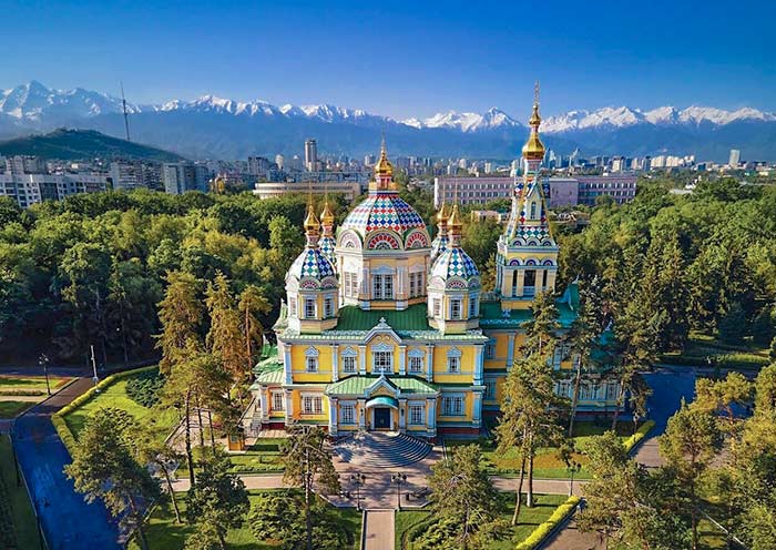
Astana Opera: It is the largest opera house in Central Asia. Its acoustics are considered among the best in the world, rivaling the famous halls of Europe.
Lovers Park (The Romantic Pause): A heart-shaped green escape right in the concrete jungle. Look for the famous "Kissing Bench"—a statue designed to capture the perfect romantic photo.
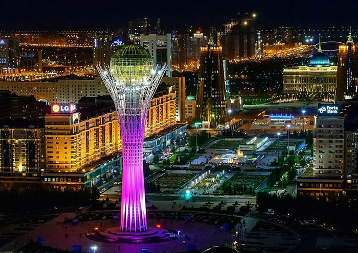
Baiterek Tower (The "Golden Egg"): The undisputed icon of the city. It represents the "Tree of Life" holding the golden egg of the mythical Samruk bird. Take the elevator to the golden sphere. Inside, you can place your hand in the gold print of the First President’s palm.
Presidential Palace (Ak Orda): It was named one of the "Most Beautiful Presidential Palaces in the World". Its blue and gold dome is one of the most photographed spots in the country.
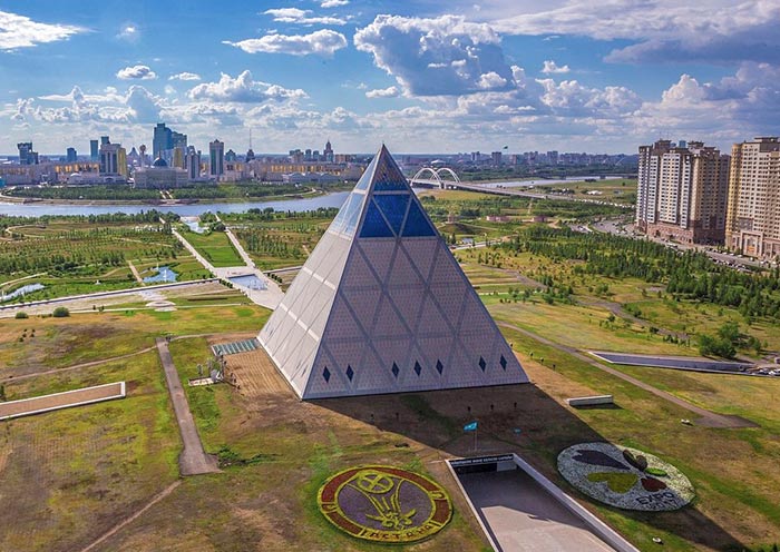
Palace of Peace and Reconciliation: Also known as "The Pyramid." It represents religious harmony and lights up beautifully at night.
Hazrat Sultan Mosque: One of the largest mosques in Central Asia, capable of holding 10,000 worshippers. Its pure white marble facade and massive dome are mesmerizing, especially at sunset.
Independence Square & Kazakh Eli Monument: The white column soars exactly 91 meters high—symbolizing the year 1991, when Kazakhstan gained independence.
National Museum: The blue-glass giant. It is home to the "Golden Man" (the Tutankhamun of Kazakhstan), the country’s most precious archaeological treasure.
The Modern South (Expo & Business)
(Suggested Time: Half Day) Located south of the main axis, this area shows the newest face of the city.
Nur Alem (Future Energy Museum): The star of the show. It is the giant glass sphere left over from Expo 2017. It is the largest spherical building in the world and totally interactive inside.
Botanical Garden: A high-tech green lung with a tropical greenhouse that keeps exotic plants alive in the middle of the freezing steppe.
"Mäñgilik Yel" Arch of Triumph: Astana's version of the Arc de Triomphe, symbolizing the eternal nation.
Abu Dhabi Plaza: You can't miss it—it is the tallest skyscraper in Central Asia, dominating the skyline.
The Riverside & Parks (Relaxing Vibe)
(Suggested Time: Half Day or Sunset) If you want to escape the concrete and feel the local life, head to the connection point between the Left and Right Banks.
Want to see all of Kazakhstan in one hour? Atameken Ethno-Memorial offers an outdoor map where you can walk like a giant among miniatures of the entire country, from the Caspian Sea to the Almaty mountains.
Astana Central Park & Qaraötkel Bridge: The city’s oldest park. Walking across the Qaraötkel Bridge gives you the classic postcard view: the calm Ishim River reflecting the futuristic skyline of the Left Bank.
Astana Metro Map: Does Astana Have a Metro?
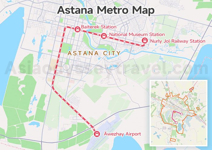
Astana does not have an underground subway; instead, it uses an elevated LRT (Light Rail Transit) system, which began trial operations in the second half of 2025. So, when you look at this "Astana Metro Map," you are actually looking at the LRT Map.
For travelers, this is the newest and most practical tool in the city. It connects the three most critical points: the Airport, the Left Bank City Center, and the Nurly Jol Railway Station (East).
- National Museum Station: Get off here to walk towards the attractions on the Right Bank axis.
- House of Ministries & Baiterek Station: This is the main stop for the Left Bank City Center. Get off here to access the Baiterek Tower and the heart of the Millennium Axis.
Astana to Almaty Map: Distance & 3 Travel Routes
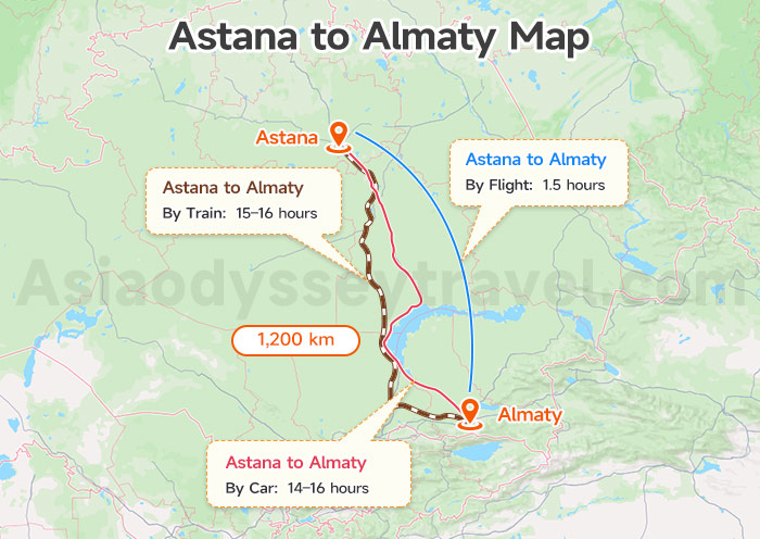
Now that you have conquered the capital, your next stop is likely Almaty. But before you pack your bags, look at the Astana to Almaty Map closely. The distance between the two capitals is a massive 1,200 km (750 miles)—roughly the same as London to Venice.
By Air: The fastest choice. It is a quick 1.5-hour flight with Air Astana or FlyArystan.
By Train: The traveler’s favorite. The high-speed Talgo train takes about 15–16 hours (best taken overnight to save on hotels), while older trains can drag on for over 24 hours.
By Car: It is a 14–16 hour drive. While the highway is decent, the flat steppe scenery gets monotonous quickly
How to Get from Astana to Almaty? (Train, Flight & Bus)
Central Asia Flight Map: Astana Connections within the 5 Stans
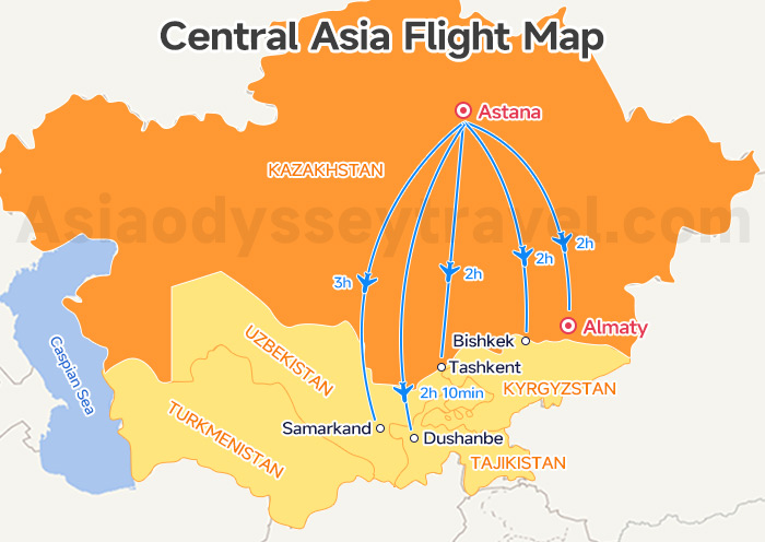
By now, the maps above have given you a quick and intuitive grasp of how to explore Astana itself. In this section, let's zoom out and focus on the capital's convenience as a transport hub. Think of it as the strategic Northern Gateway to the Central Asia "Stans."
From here, you are likely heading to your next country or flying south to Almaty. Let’s use our Astana Flights Map and the table below to clearly visualize your available connections.
| Country | Destination City | Airport Code | Flight Time |
|---|---|---|---|
| Kazakhstan | Almaty | ALA | 2h |
| Kyrgyzstan | Bishkek | BSZ | 2h |
| Tajikistan | Dushanbe | DYU | 2h 10m |
| Uzbekistan | Tashkent | TAS | 2h |
| Uzbekistan | Samarkand | SKD | 3h |
Stans Maps: 10 Maps of Central Asia (Countries, Capitals, Routes) | 2026
Explore Kazakhstan With Asia Odyssey Travel (AOT)
Skip the stress of language barriers and complex logistics. Asia Odyssey Travel handles everything—from professional drivers to English-speaking guides—so you can focus on the "all-round" surprise of Central Asia.
Check out our top-rated options:
- ✅ Kazakhstan Group Tours – The best-value choice. Enjoy 4-star comfort, safety, and authentic experiences in guaranteed small groups (1-16 people).
- ✅ Kazakhstan Tour Packages – Flexible private or group itineraries covering Almaty’s alpine nature (Charyn Canyon, Kolsai Lakes) and Astana’s futuristic architecture.
- ✅ Central Asia Grand Tours – Epic multi-country journeys (up to 26 days) that extend your adventure across the "5 Stans" of the Silk Road.
")


")
 Map 2026: Explore Ashgabat on Map for Location & Sights")
 with Map (2026)")


")
: Tourist Regions, Cities & Surrounding Countries")
 | 2026")