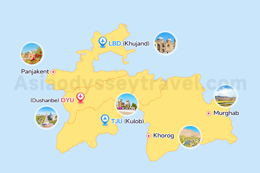
Where is Dushanbe Located? (Dushanbe Tajikistan Map)
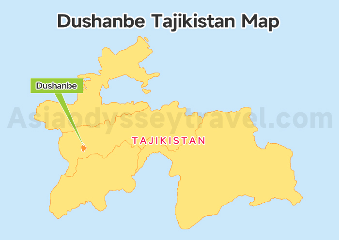
Dushanbe is the capital of Tajikistan, and as you can clearly see on this Dushanbe Tajikistan map, it anchors the country's southwest corner.
- Coordinates: 5598° N, 68.7870° E
- Elevation: ~800 meters (2,625 ft)
- Perspective: To give you a better idea of its position, Dushanbe sits on roughly the same latitude as San Francisco or Seville.
So, where does it fit in the region? The city is located just 60 km (37 miles) east of the Uzbekistan border. Within Tajikistan itself, it serves as the vital gateway to the northern hubs of Khujand and Penjikent, which lie on the other side of the mountain ranges.
Fun fact: “Dushanbe” means “Monday” in Tajik, named after a Monday marketplace that existed here during the late 19th century.
Tajikistan Map (2026): Tourist Regions, Cities & Surrounding Countries
Dushanbe on Map: The 4 Districts vs. Tourist Area
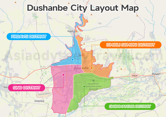
Official maps can be confusing. If you look at an administrative Dushanbe on map guide, you will see the city divided into four big districts:
- Ismoili Somoni District (Tourist Area)– The most central and important district; home to key attractions and government buildings.
- Firdavsi District – Slightly westward, both residential and industrial.
- Sino District – Located in the south, this is mainly residential and home to the train station and airport.
- Shohmansur District – In the east, featuring local markets and older neighborhoods.
Focus your eyes on the center of the map. Almost everything you want to see—museums, parks, good coffee shops, and hotels—is located in the Ismoili Somoni district. This is where you'll find major landmarks, hotels, restaurants, and parks are within a 2–3 km radius of this area.
If you are looking at this map to decide where to walk, just find the big green patches. Dushanbe is famous for being a "Garden City." The map is covered in parks. If you stick to the central vertical line of the city, you are in the safe, beautiful, and walkable tourist zone.
You rarely need to go deep into the East or West residential suburbs unless you are visiting a local friend.
For first-time visitors, the key takeaway is simple: Dushanbe tourism is highly centralized. Unlike sprawling megacities, most attractions are clustered together, making the city easy to navigate even without extensive planning.
Dushanbe City Map: City Center, Transportation Hubs & Where to Stay

Though Dushanbe is the largest city in Tajikistan, it is relatively small and manageable by global standards. Most attractions, hotels, and cafes are located around the city center, making it ideal for walking or short taxi rides.
This Dushanbe City Map highlight three things: the main artery, the airport, and the hotel zones.
Rudaki Avenue: The Main Boulevard
Open your Dushanbe city map or Google Maps, and let's mark the most critical road: Rudaki Avenue.
Your mental map of Dushanbe should revolve around Rudaki Avenue (Prospekt Rudaki). This street runs north-to-south through the entire city center. It is the Champs-Élysées of Tajikistan. If you book a hotel on or near Rudaki Avenue, you are in the right place.
Along this avenue, the northern end is greener and quieter, featuring the Botanical Gardens. The central part is the heartbeat of the nation, home to the Parliament and the Central Park (Rudaki Park). The southern end leads toward the train station and busier commercial zones.
Transportation hubs: Check 3 Marked key locations on Map
Dushanbe International Airport (DYU): Located in the southeast (Shohmansur district). It is incredibly close to the city center—only a 15-minute drive.
The Railway Station: Located at the southern tip of Rudaki Avenue. While trains are less common for tourists than shared taxis, the square here is a major landmark.
Shared Taxi Terminals: This is crucial. If you want to get to north cities like Khujand, Penjikent, Smarkant, You need the “Shared Taxi Khujand" terminal (Gorborg) on the northern edge of the city.
Where to Stay on the Map?
For most tourists, the best area to stay is the rectangle formed by Rudaki Avenue and Ismoil Somoni Avenue.
Luxury: The Hyatt Regency and the Sheraton are located slightly off the main drag but near the Komsomol Lake, offering resort-style security and comfort. The Serena Hotel, located directly on Rudaki, is often the favorite for its stunning architecture and central location.
Mid-Range & Boutique: Look for hotels near the Opera Ballet Theatre. This area is leafy, safe, and filled with cafes that serve excellent cappuccinos—a pleasant surprise for many travelers.
Budget/Hostels: These are scattered, but the best ones are often tucked into the quiet courtyards behind the grand facades of Rudaki Avenue.
Dushanbe Tourist Map: Top 10 Attractions to Visit
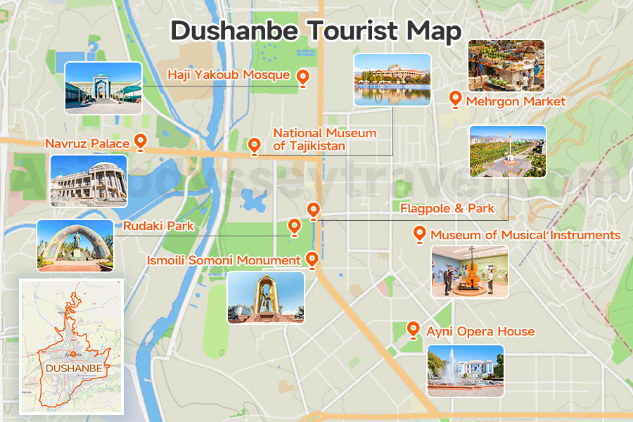
Navigating the sights in Dushanbe is lovely because you can mostly walk. A good Dushanbe tourist map is basically a map of Rudaki Avenue and the parks next to it. You should start your day at the north of the center and walk south.
Flagpole & Park – At the north end of Rudaki. On the Dushanbe tourist map, look for the massive green area in the center. This is Rudaki Park. You will see the giant flagpole (it used to be the tallest in the world). It is a great landmark to orient yourself. If you can see the flag, you know where the center is.
National Museum of Tajikistan – Massive building you can't miss. Gold exterior. The archaeology section with Buddhist artifacts from Penjikent is the highlight.
Navruz Palace – Across from the museum. This is Tajikistan's wedding cake palace. Sometimes you can peek inside if there's no event. The outside photo op is worth it.
Rudaki Park – The central green space on Rudaki Avenue. Locals gather here in evenings. There's a big statue of Rudaki (a Persian poet) in the center.
Somoni Statue Keep moving south on your Dushanbe tourist map. You will hit the massive golden statue of Ismoili Somoni. This is the photo spot. It is the "Times Square" of Tajikistan, but much quieter.
Gurminj Museum of Musical Instruments – Small but fascinating. About 100 traditional instruments. The guide plays some if you ask nicely. Takes one hour maximum.
Mehrgon Bazaar This is slightly off the main Rudaki line. Look at the north-east part of your Dushanbe tourist map. It is a beautiful, clean, indoor market. It is not as chaotic as other Asian markets. It is a great place to buy nuts and dried fruits.
Kokhi Navruz Look at the map near the Hyatt Regency. This is a "Teahouse," but that is an understatement. It is a palace. You must find this on your Dushanbe tourist map and go for a tour. The wood carving inside is unbelievable.
Ayni Opera House – Southern landmark on Rudaki. Soviet-era building still hosting performances. Even if you don't watch a show, the building makes a good orientation point.
Haji Yakoub Mosque – The main mosque near Green Bazaar. Modern building (finished 2019). Non-Muslims can visit outside prayer times.
Looking at these on a Dushanbe tourist map, you'll notice they form a rough line. That's intentional Soviet planning. You can hit the major ones in a long morning walk or split them across two days.
What to Do in Tajikistan 2026: 10 Tourist Spots & Experiences Worth the Trip
Dushanbe Transportation Map: Map to Khujand & Penjikent
While Dushanbe rewards exploration, many visitors use the capital as a base for excursions into Tajikistan's legendary mountain scenery. Two destinations consistently top the list: Khujand in the north and Penjikent to the west.
Dushanbe to Khujand Map
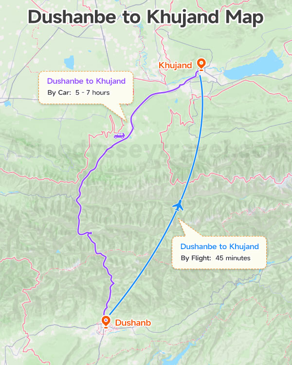
Khujand is the second biggest city in Tajikistan. It is about 305 km away. The drive usually takes 5 to 7 hours.
Shared Taxis leave from Dushanbe all day. The road goes over the mountains. You will pass the Anzob Pass (or go through the long Istiklol Tunnel). Then, the road goes down into the green Fergana Valley. There are short flights, too. They connect the two cities in just 45 minutes.
How to Get from Dushanbe to Khujand? (2026 Guide)
Dushanbe to Penjikent Map
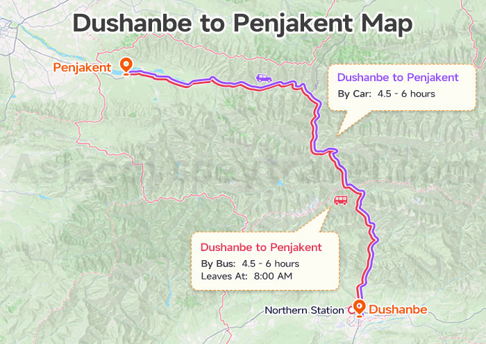
If you look west on the map, toward Samarkand (Uzbekistan), you will find Penjikent. Penjikent is closer. It is about 270 km to the northwest. The trip takes 4.5 to 6 hours.
This ancient city is near the Uzbekistan border. It has amazing old ruins. It is also the starting point for the beautiful lakes in the Fann Mountains. You can find Shared taxi at the Northern Station. There is one bus every day. It leaves at 8:00 AM. The bus stop is near the city center.
Dushanbe to Panjakent (2026): Shared Taxi, Bus & Samarkand Border Guide
Dushanbe Connection Map: Flights & Multi-Stan Trips
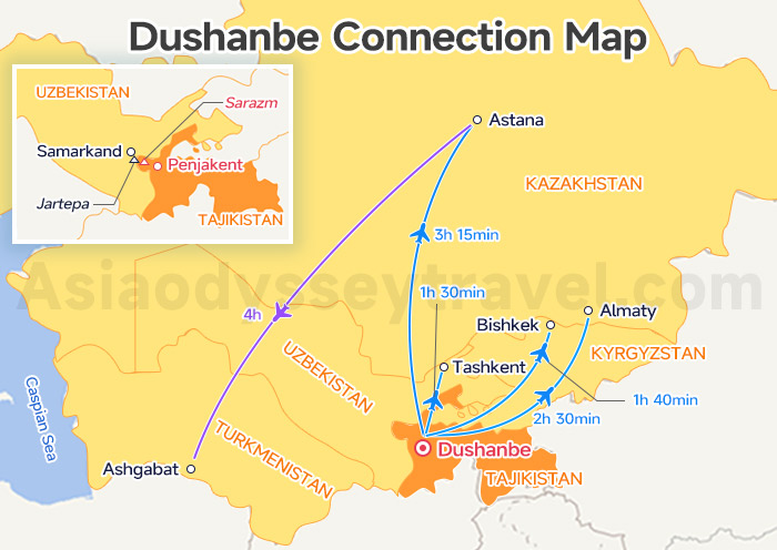
Most travelers do not just visit Dushanbe. They are usually on a bigger trip. They visit several "Stan" countries in one go. Look at the West side of our Dushanbe Map: You will see the Penjikent border crossing. This is a very popular choice for travelers going to Samarkand (in Uzbekistan).
And check the "Dushanbe Connection Map". This map shows flight connections to other countries in Central Asia. It helps you see new travel ideas and plan a combined trip.
Stans Maps: 10 Maps of Central Asia (Countries, Capitals, Routes) | 2026
Travel to Tajikistan With Asia Odyssey Travel
Tajikistan is 90% mountains—a pristine, high-altitude paradise perfect for a cool summer escape. Asia Odyssey Travel handles the rugged logistics and border crossings, making your trip to the "Roof of the World" safe and seamless. You just show up and enjoy.
✅ Tajikistan Tour Packages – In-depth journeys covering Dushanbe, Khujand, and the turquoise gem of Iskanderkul Lake.
✅ Central Asia Combo – Expertly connected multi-country routes that blend Persian history with Pamir landscapes.
✅ Dushanbe Tours: Dive into the Persian heart of Central Asia, covering Rudaki Park, museums, and the ancient Hissar Fortress.
: Tourist Regions, Cities & Surrounding Countries")
")


")
 Map 2026: Explore Ashgabat on Map for Location & Sights")
 with Map (2026)")


 | 2026")