Central Asia on World Map: Where is Central Asia on a Map?
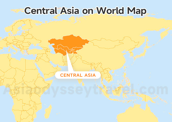
Where is Central Asia on a map? Take a look at our Central Asia on World Map here! You'll see this region sitting right in the heart of the Asian continent.
It acts like a giant bridge. It connects the busy markets of China in the East with the edges of Europe and the Middle East in the West.
As you can see on this map, we are tucked between some big neighbors.
To the north is the huge expanse of Russia. To the south, we share borders with Afghanistan and Iran. The Caspian Sea marks our western edge. To the east, the tall Tien Shan mountains stand like guards.
Stan Countries Map: What Are All the Stans?
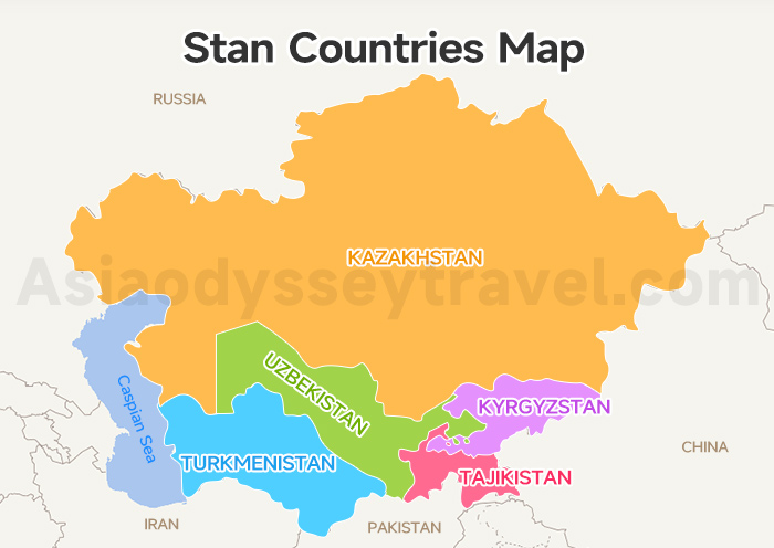
Once you zoom in from that big world view, the borders start to take shape! This is where you'll need our Stan Countries Map to see how the region is divided.
You'll quickly notice that Central Asia is made up of 5 distinct Stans. In the local Persian tongue, that suffix simply means "Land of."
So, what are all the Stans? Here is a quick look at the 5 neighbors you'll meet on your Map of the Stans Countries:
| Country | What Does It Mean? | Why You'll Love It |
|---|---|---|
| Kazakhstan | Land of the Kazakhs | Endless grassy steppes and futuristic cities like Almaty. |
| Kyrgyzstan | Land of the Kyrgyz | A mountain lover's dream with lakeside yurt stays. |
| Uzbekistan | Land of the Uzbeks | The heart of the Silk Road with blue-tiled mosques. |
| Tajikistan | Land of the Tajiks | Home to the epic Pamir Highway and high-altitude lakes. |
| Turkmenistan | Land of the Turkmen | Mysterious deserts and the glowing "Gates of Hell." |
Central Asia Map with Capitals
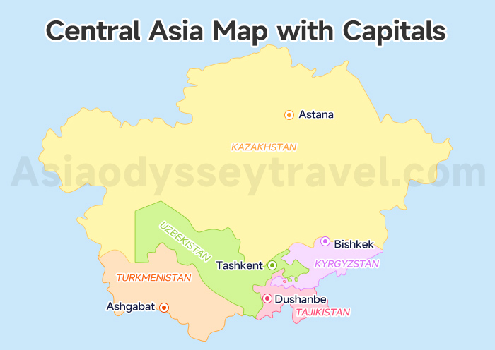
Now that you know the 5 countries, let's look at where you'll be landing and staying! If you check a Central Asia Map with Capitals, you'll see that each country has a main city that serves as its heartbeat.
These are the places where you'll find the best hotels, change your money, and meet your local guides before heading out into the wild.
| Country | Capitals | Must-Go Cities | Main Transport Hubs |
|---|---|---|---|
| Kazakhstan | Astana | Almaty | Astana Airport (NQZ) |
| Kyrgyzstan | Bishkek | Karakol, Cholpon-Ata | Manas Airport (FRU) |
| Uzbekistan | Tashkent | Samarkand, Bukhara, Khiva | Tashkent Airport (TAS) |
| Tajikistan | Dushanbe | Penjikent | Dushanbe Airport (DYU) |
| Turkmenistan | Ashgabat | Mary, Darvaza | Ashgabat Airport (ASB) |
Insider Tip: Tashkent and Almaty are the biggest dots. Most international flights land in one of these two cities, so they are the perfect places to start your journey!
Astana Map 2026: Tourist Map of Astana City, Metro & Attractions
Bishkek City Map: English Map of Bishkek for Location, Attractions
Ashgabat (City) Map 2026: Explore Ashgabat on Map for Location & Sights
Tashkent Map: Tourist Map of Tashkent Metro & Attractions
Dushanbe Map, Tajikistan: Latest Dushanbe City Map for Tourist (2026)
Central Asia Silk Road Map: The Ancient Routes
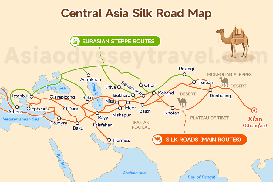
Long before we had airplanes and high-speed trains, this region was the center of the world!
When you look at a Central Asia Silk Road Map, you'll see that it wasn't just one single road. Instead, it was a massive, messy web of caravan paths that connected the East to the West for over 1,500 years!
To help you visualize how these traders moved across the "Stans," here are the primary routes they followed.
| Route Name | Where It Goes | Key Stops in Central Asia |
|---|---|---|
| Northern Route | From China, it splits to go north and south of the mountains. One path goes north of the Tian Shan mountains. | Almaty (Kazakhstan), Talgar, Kokand (Fergana Valley), and Termez (Uzbekistan). |
| Southern Route | A high-mountain path through the Karakoram range (now a famous highway). | Crosses through Afghanistan and Pakistan before rejoining the others at Merv (Turkmenistan). |
| The Main Junction | Where the paths meet before heading to Persia (Iran) and Europe. | Merv (Turkmenistan) is the big meeting point where the Northern and Southern routes join. |
As you can see on this Central Asia Silk Road Map, these paths all woven together to make Uzbekistan the ultimate meeting place in Central Asia!
Whether a trader was coming from the snowy Pamirs or the sandy Kyzylkum desert near Khiva, they were all heading toward the same legendary markets.
Other Global Paths
- Southwestern Route: A "hidden" path through mountains and rivers, connecting China to Bangladesh and India.
- Maritime Silk Road: The sea version! Instead of camels, sailors used large ships to carry spices and silk between Southeast Asia, India, and Africa.
What was traded?
It wasn't just silk!
Caravans heading to China carried dates, saffron, pistachios, frankincense, and even glass bottles from Egypt. Meanwhile, goods leaving China included bolts of beautiful silk, shiny lacquer-ware, and fine porcelain.
Travel Map of the Stans: The 16-Day & 21-Day Loops on Central Asia Map
Now for the fun part—your trip!
Looking at a Central Asia Map can be overwhelming because the region is huge. I've picked 2 popular routes that hit the best spots. You can find them on our Travel Map of the Stans.
A quick tip: many of our travelers use "Open Jaw" flights. You can also fly into Almaty and leave from Ashgabat or Tashkent. This saves time and keeps you moving forward!
Route One: 16-Day "Essential" Loop on Map of the Stans
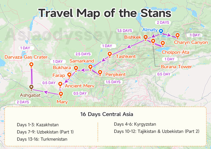
This Travel Map of the Stans is great if you want the greatest hits in about 2 weeks. It's a fast-paced adventure through canyons, lakes, and deserts.
Days 1-3: Kazakhstan. Land in Almaty. Spend your time exploring the Green Bazaar, the Zenkov Cathedral, and the stunning red rocks of Charyn Canyon.
Days 4-6: Kyrgyzstan. Take a short flight to Bishkek. Walk through Ala-Too Square and then head out to the massive Issyk-Kul Lake to see ancient petroglyphs.
Days 7-9: Uzbekistan (Part 1). Fly to Tashkent for a metro tour, then hop on a train to Samarkand. Standing in Registan Square at sunset is a moment you'll never forget!
Days 10-12: Tajikistan & Uzbekistan (Part 2). Cross the border for a day hike at the Seven Lakes in Tajikistan. Then, head back to Bukhara to see the famous "Ark" fortress.
Days 13-16: Turkmenistan. Cross into the desert to see the ruins of Ancient Merv. The highlight? Camping next to the Darvaza Gas Crater—the "Gates of Hell"—before finishing in Ashgabat.
Route Two: 21-Day "Grand" Expedition on Map of the Stans
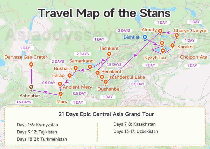
If you have 3 weeks, this Travel Map of the Stans is the way to go. It adds "slow travel" moments like meeting eagle hunters and driving deeper into the mountains.
Days 1-6: Kyrgyzstan. Start in Bishkek. Visit the Burana Tower and stay in the mountains. You'll meet eagle hunters and learn to make a yurt near Issyk-Kul Lake.
Days 7-8: Kazakhstan. Cross the border to explore the stunning Charyn Canyon. Spend time in Almaty visiting the Green Bazaar and Zenkov Cathedral.
Days 9-12: Tajikistan. Fly to Dushanbe. Hike to the turquoise waters of Iskanderkul Lake and explore the ruins of Ancient Penjikent.
Days 13-17: Uzbekistan. Take the train through the "Golden Triangle." Enjoy plenty of time in the blue-tiled alleys of Samarkand, Tashkent, and Bukhara.
Days 18-21: Turkmenistan. Explore the white-marble city of Ashgabat and the "Gates of Hell" crater in the desert.
Tourist Attraction Map of the Stans: The Must-Sees on Central Asia Map
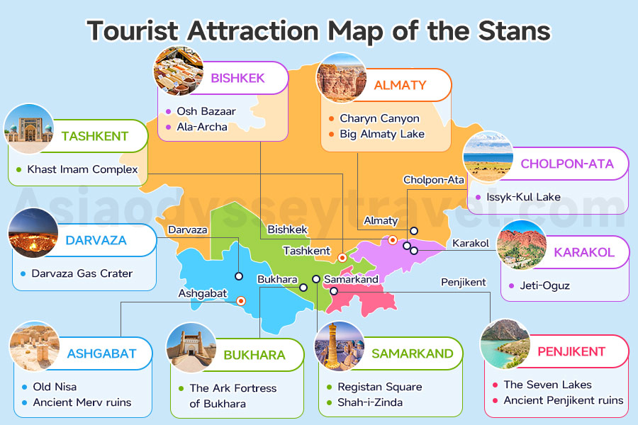
Knowing the route is one thing, but knowing what to look for is where the real magic happens!
If you look at a Tourist Attraction Map of the Stans, you'll see the must-see sights that define each country. These are the "soul" of the region.
Here I've put together a quick list of the must-see tourist attractions you should mark:
| Country | Must-See Tourist Attractions |
|---|---|
| Kazakhstan | Almaty: Charyn Canyon, Big Almaty Lake |
| Kyrgyzstan | Bishkek: Osh Bazaar, Ala-Archa; Cholpon-Ata: Issyk-Kul Lake; Karakol: Jeti-Oguz |
| Uzbekistan | Tashkent: Khast Imam Complex; Samarkand: Registan Square, Shah-i-Zinda; Bukhara: The Ark Fortress of Bukhara |
| Tajikistan | Penjikent: The Seven Lakes, Ancient Penjikent ruins |
| Turkmenistan | Ashgabat: Old Nisa, Ancient Merv ruins; Darvaza: Darvaza Gas Crater |
Almaty Map 2026: Kazakhstan Almaty Map of City, Metro & Tourist
Samarkand Map: Explore Samarkand City with Map
Bukhara Map: 2026 Tourist Map of Bukhara City in Uzbekistan
Khiva Map: How to Visit Khiva (Old Town) with Map (2026)
Transportation Map of the Stans: How to Getting Around Central Asia?
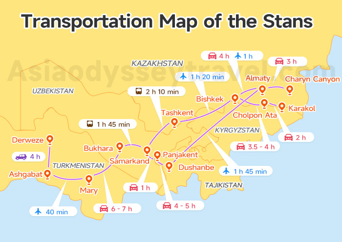
After the bucket list ready, let's now talk about how to navigate this region on our Transportation Map of the Stans.
The journey here is part of the adventure! One day you might be on a sleek, high-speed train in Uzbekistan, and the next, you're in a 4x4 vehicle crossing a remote desert border.
Understanding these connections is the secret to a smooth trip!
To help you plan, here is a table of the most common ways we link these iconic cities and sights together:
| Route | Best Way to Travel | Distance | Estimated Duration |
|---|---|---|---|
| Almaty to Charyn Canyon | Car | ~200 km | 3 hours |
| Almaty to Bishkek (via Korday Border) | Flight / Car | ~240 km | 1 hr (flight) / 4 hrs (car) |
| Bishkek to Cholpon-Ata (Issyk-Kul) | Car | ~260 km | 3.5 - 4 hours |
| Cholpon-Ata to Karakol | Car | ~140 km | 2 hours |
| Bishkek to Tashkent | Flight | ~470 km | 1 hr 20 mins |
| Tashkent to Samarkand | Train (High-speed) | ~300 km | 2 hr 10 mins |
| Samarkand to Penjikent (via Jartepa Border) | Car | ~62 km | 1 hour |
| Samarkand to Bukhara | Train | ~230 km | 1 hr 45 mins |
| Bukhara to Mary (via Farap Border) | Car | ~380 km | 6 - 7 hours (inc. border) |
| Mary to Ashgabat | Flight | ~350 km | 40 minutes |
| Ashgabat to Darvaza | 4x4 Car | ~260 km | 4 hours |
| Almaty to Dushanbe | Flight | ~480 km | 1 hr 45 mins |
| Dushanbe to Penjikent | Car | ~230 km | 4 - 5 hours |
Central Asia Railway Map: Riding the Iron Silk Road
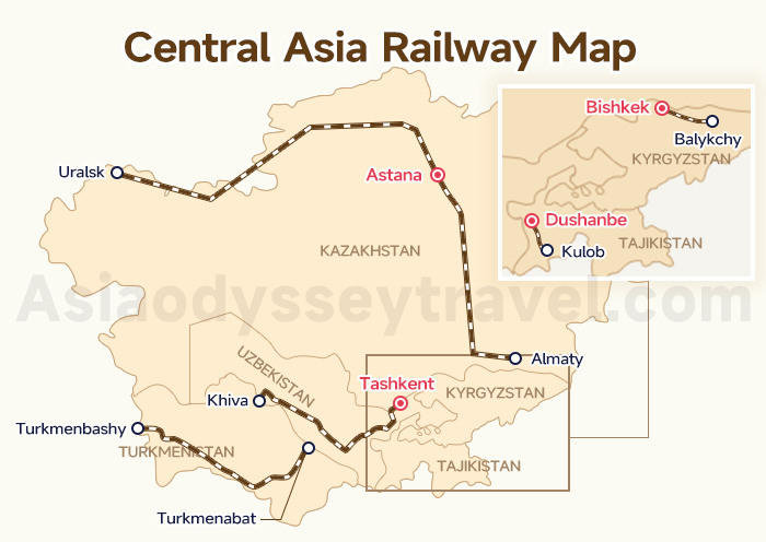
If the ancient Silk Road was defined by camel caravans, the modern one is defined by the whistle of a train. Looking at a Central Asia Railway Map, you'll see that the desert is no longer a barrier—it's a high-speed highway!
Here is a breakdown of the 5 national railway systems in Central Asia, including their start and end points for travelers and key stations along the way.
| National Railway System | Start & End Points | Important Railway Stations |
|---|---|---|
| Uzbekistan Railways (UTY) | Tashkent ↔ Khiva | Samarkand, Bukhara, Navoi, Urgench, Nukus, Termez |
| Kazakhstan Railways (KTZ) | Almaty ↔ Astana ↔ Uralsk | Shymkent, Turkistan, Aktogay, Dostyk (China border), Aktau |
| Turkmenistan Railways (TADY) | Turkmenbashy ↔ Turkmenabat | Mary (Merv), Turkmenbashy (Caspian port), Farap, Serakhs |
| Tajikistan Railways (RT) | Dushanbe ↔ Kulob | Khujand (North), Bokhtar (South), Penjikent, Kanibadam |
| Kyrgyzstan Railways (KRG) | Bishkek ↔ Balykchy | Bishkek-2, Balykchy (Issyk-Kul), Osh (South), Jalal-Abad |
Central Asia Borders on Map of the Stans: Where Can You Cross Easily?
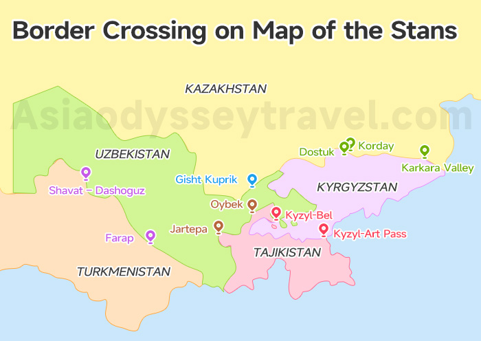
The borders on a Map of the Stans can look like a zig-zag, especially where 3 countries meet in the Fergana Valley. On this map, we mark the international checkpoints—these are the specific gates where you are allowed to cross.
Just a heads-up: keep your passport and visa handy, wear a smile, and be ready for a little bit of "No Man's Land" walking between the two gates!
Here are the main gates you'll likely use to hop between countries:
| Border Between | Crossing Name(s) | Why Use It |
|---|---|---|
| Kazakhstan & Kyrgyzstan | Korday (Ak-Zhol) | The main road between Almaty and Bishkek. It's busy but fast. |
| Karkara Valley (Kegen) | The scenic "mountain route" from Almaty to Karakol. | |
| Kyrgyzstan & Uzbekistan | Dostuk (Dustlyk) | Links the city of Osh (KG) to the beautiful Fergana Valley (UZ). |
| Kyrgyzstan & Tajikistan | Kyzyl-Art Pass | The high-altitude gateway on the famous Pamir Highway. |
| Kyzyl-Bel (Guliston) | A lower, easier road between Osh and Khujand. | |
| Tajikistan & Uzbekistan | Jartepa (Sarazm) | The quick 1-hour hop from Samarkand (UZ) to Penjikent (TJ). |
| Oybek | The standard road between Tashkent and Khujand. | |
| Uzbekistan & Kazakhstan | Gisht Kuprik | The "front door" connecting Tashkent and Shymkent. |
| Uzbekistan & Turkmenistan | Shavat – Dashoguz | Used to reach the desert ruins of Kunya-Urgench from Khiva. |
| Farap (Alat) | The main desert crossing from Bukhara toward Mary (Merv). |
Uzbekistan Tajikistan Border: Itineraries & Crossing Guide
Uzbekistan–Kazakhstan Border: Name, Distance & Tips
Cross Kazakhstan Kyrgyzstan Border (2026): 3 Points, 5 Options
Grab Your 5 Stans Map, Explore Central Asia with Confidence!
Central Asia is no longer a mystery—it's your next big adventure with our 5 Stans maps!
We love welcoming explorers from all over! Whether you're joining a Central Asia tour from Singapore, Malaysia, or the Philippines, or booking Central Asia tour packages from the UK, USA, India, or Australia, we've got a spot for you.
✔ For Sightseers: Check out our budget-friendly Central Asia Group Tours to meet new friends, or go for a customized Central Asia Tour to set your own pace.
✔ For Culture Lovers: Dive into history with our Private Silk Road Tours or join a Silk Road Group Tour. We even offer China Silk Road Tours to help you follow the whole legendary path!
Ready to turn these maps into real memories? Would you like me to help you pick the best month for your specific route?
")
 Map 2026: Explore Ashgabat on Map for Location & Sights")


")


 with Map (2026)")


")
: Tourist Regions, Cities & Surrounding Countries")