Almaty Map Kazakhstan: Where is Almaty on the World Map?
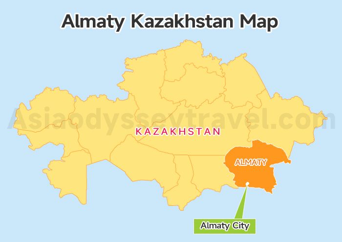
Most travelers I meet think Almaty is somewhere "near Russia" or "Central Asia, so middle of nowhere." This Almaty Kazakhstan map shows what actually matters for your trip planning: Almaty sits in southeastern Kazakhstan, and it is located at 43.2°N, 76.9°E.
Almaty pressed against the northern slopes of the Tian Shan mountain range at elevations between 600m (city center) and 1,700m (southern suburbs). The city is 15km from Kyrgyzstan's border to the south and southeast.
Here is the quick geographic breakdown:
| Feature | Data / Description | Impact on Travel |
|---|---|---|
| Coordinates | 43°N, 76°E | Same latitude as Florence, Italy (Milder weather). |
| Altitude | 700m – 900m | The city slopes "Up" towards the mountains. |
| Nearest Neighbor | Bishkek (KG) | Only 235 km away (Easy land crossing). |
| Distance to Capital | Astana (NQZ) | 1,200 km North (Requires a 1.5h Flight). |
| Geography | Mountain Foothills | Offers instant access to hiking/skiing (Medeu). |
Kazakhstan Map 2026: Map of Kazakhstan Country, Cities, Tourist (Free View)
Almaty on Map (Detailed City Layout): Districts & The "Up-Down" Orientation
Almaty doesn't work like normal cities where you say "north side" or "downtown." Every local I've asked for directions says "up" (вверх/vverkh) or "down" (вниз/vniz)—and they mean it literally.
The city climbs 1,100m in elevation from the northern flatlands (600m) to the southern mountain foothills (1,700m).
Look at this detailed Almaty on map. You will see the massive Trans-Ili Alatau mountains walling off the south. This geography dictates the local compass:
- "Up" (South): Heading towards the mountains. The elevation rises. This is where you find the wealthy neighborhoods and nature spots.
- "Down" (North): Heading away from the mountains toward the flat steppe. This road leads to the old railway station (Almaty-1) and the Airport.
And Almaty is a near-perfect grid. Streets running East-West (like Abay and Gogol) are flat. Streets running North-South (like Dostyk and Nazarbayev) are sloped. Street slopes upward as you walk? You're heading south toward the mountains.
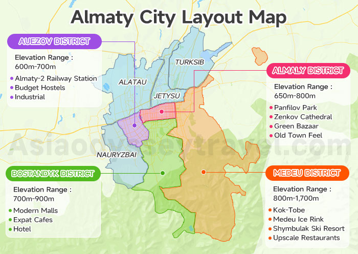
The Four Districts That Matter to Travelers
Almaty has 8 administrative districts, but tourists only need to focus on the four that make up the city's vibrant core. We have highlighted these specific areas in different colors on the map.
| District | Elevation Range | What's Here | Distance from Airport (ALA) |
|---|---|---|---|
| Medeu District (southern) | 800m-1,700m | Kok-Tobe, Medeu ice rink, Shymbulak ski resort access, upscale restaurants | 25km, 35-45 min |
| Almaly District (city center) | 650m-800m | Panfilov Park, Zenkov Cathedral, Green Bazaar, old town feel | 18km, 25-30 min by taxi |
| Bostandyk District (central-west) | 700m-900m | Modern malls (Dostyk Plaza, Esentai Mall), expat cafes, Hotel Kazakhstan | 20km, 30-35 min |
| Auezov District (northern flatlands) | 600m-700m | Almaty-2 railway station, budget hostels, industrial | 12km, 20-25 min |
Almaty City Map: Transport Hubs, Best Area to Stay & Where to Eat
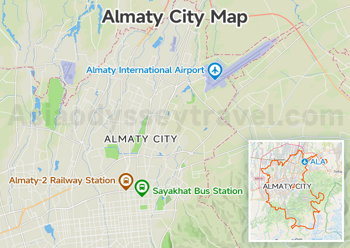
If you look closely at the Almaty city map, you'll see that the transport hubs are located in the gritty, industrial "North" (Down). The real action is strictly in the center.
The Three Transport Hubs: Airport & Train Stations
Hub 1: Almaty International Airport (ALA) (Northeast, No Metro). It located 15km northeast of city center, near Boraldai village. For arrivals, exit baggage claim, turn right, walk 50m to parking lot exit—drivers wait there.
Hub 2: Almaty-2 Railway Station (Far North, Has Metro). It is 8km from city center. All overnight trains departure here.
- Location: Ablay Khan Avenue, northern industrial zone
- The station has two waiting halls—domestic (left entrance) and international (right entrance, for trains to Russia). Buy tickets at window #3-7 (English-speaking staff during day shifts).
Hub 3: Sayakhat Bus Station (Northern Edge, No Metro). From here, you can catch international buses to Bishkek, Lake Issyk-Kul, and Shymkent. The nearest metro stop is Zhibek Zholy station.
The "Dostyk-Furmanov Rectangle": Your Main Tourist Rectangle
And to understand the Almaty city layout, look at the dense grid in the center of our map. That is the " Rectangle."
I call this the Tourist Rectangle, and honestly, 90% of everything you’ll want to see fits inside this compact 2km zone. It is essentially the area sandwiched between two main streets: Dostyk Avenue and Furmanov Street.
At the top end, you have the famous Panfilov Park and the colorful Zenkov Cathedral. From there, it is just a pleasant 25-minute walk south—past Republic Square and the Central State Museum—to reach the Kok-Tobe cable car station at the bottom end.
Where to Stay on Your Almaty City Map
If you ask a local 'Where is the best place to stay?', you will get the same answer every time: the Almaly District, specifically the 'Golden Rectangle.'
This is the area we mentioned earlier, and for good reason. It is hands-down the best base for first-time visitors, putting you within walking distance of just about every major attraction.
However, that isn't your only choice. We have also color-coded two other distinct accommodation zones on this map of Almaty city to help you decide.
| Area | Vibe | Best For... |
|---|---|---|
| The Golden Rectangle | Leafy, Soviet chic, walkable. | First-timers. It only steps from Panfilov Park. |
| Dostyk Ave | Upscale, high-rise views. | Luxury. Great for mountain views (e.g., Hotel Kazakhstan). |
| Samal Districts | Modern malls, residential. | Families. Near Dostyk Plaza, but requires taxis. |
Where to Eat: The Food Streets of Almaty City
Just look for the food icons on our Almaty city map. We have marked the streets where you can find all kinds of dining options in the city center.
Panfilov Street (Pedestrian Zone): The tourist magnet. Lined with terraces, buskers, and local chains. Great for people watching.
Kabanbai Batyr St: The "Hipster Artery." This is where you find the best coffee shops (Flask, Bowler) and wine bars.
Abay Ave: The main commercial strip. Good for fast, reliable meals.
Dostyk Plaza corridor offers Georgian/European.
Inside Tips: Download 2GIS offline map and Yandex.Taxi. These two apps will navigate you better than Google Maps, which still thinks half of Almaty's restaurants closed in 2019.
Almaty Tourist Map (City Core): Top Attractions & Walking Route
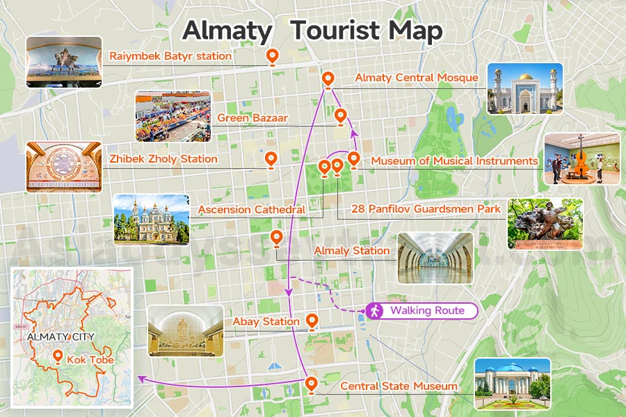
Open the Almaty tourist map we've created for this guide. We've plotted a north-to-south walking route that connects 13 top attractions in sequence, and the map shows you can cover them all on foot in one day.
The walking route runs 4.2km total, following the natural flow from Panfilov Park down to Kok Tobe.
Almaty Top Attractions and Classic Walking Route
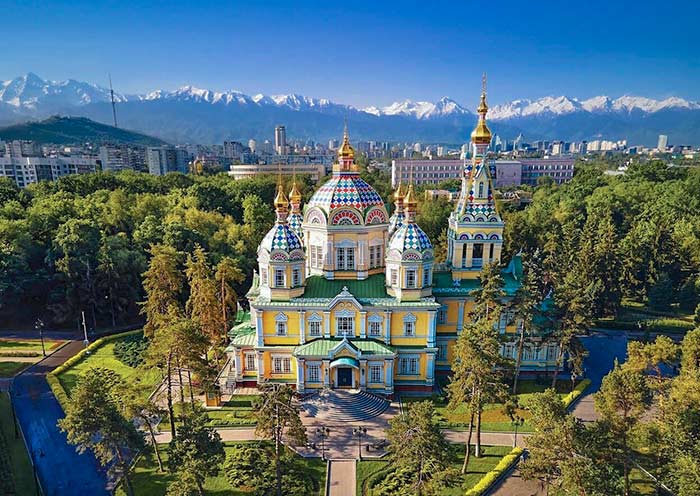
Start at 28 Panfilov Guardsmen Park. This green square holds four attractions: Ascension Cathedral, the iconic yellow wooden church built in 1907 without a single nail.
Museum of Musical Instruments (showcasing Kazakh dombra and kobyz); Military History Museum (Soviet-era tanks and medals). The park itself is the memorial—28 soldiers who stopped Nazi tanks in 1941.
Green Bazaar & Almaty Central Mosque (15-minute walk east). The Green Bazaar is Almaty's oldest market. This is your midpoint break. Cross the street to Almaty Central Mosque (1999, blue dome visible from blocks away, free entry but dress modestly).
The tourist map of Almaty marks four metro stations along the route—Raiymbek Batyr, Zhibek Zholy, Almaly, Abay—not as attractions, but as rest points and orientation anchors. Each sits 8-12 minutes apart.
Central State Museum (20-minute walk south from Panfilov Park). The Golden Man exhibit—Scythian warrior armor from 500 BC—is the highlight. This is your midpoint break.
Kok Tobe (Final stop, 3km uphill). Take the cable car from near Abay Station (6-minute ride). At 1,100m elevation, you get 360° views of the city grid you just walked. Beatles monument, mini zoo, and overpriced cafés at the summit.
How to Use This Almaty City Tourist Map?
The Almaty walking route map is designed for one continuous journey. Start at Panfilov Park (easily reached from Zhibek Zholy Metro), follow the numbered sequence, and finish at Kok Tobe by sunset.
Total walking time: 1.5 hours. Total sightseeing time with museum stops: 6-7 hours.
12 Best Things to Do in Almaty & Top Attractions: The 2026 City-to-Mountain List
Almaty Tourist Map (Surroundings): Day Trips & Golden Triangle Loop
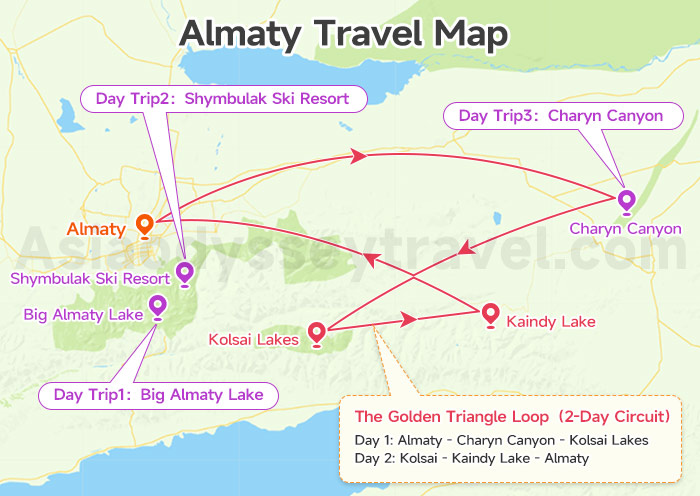
Zoom out on the Almaty tourist map and you'll see two types of destinations marked in the surrounding mountains: three single-day trips close to the city, and one legendary loop that takes 2-3 days. The surroundings map of Almaty shows exactly each routes work.
The Three Day Trips (Single-Day Returns)
Trip 1: Big Almaty Lake (28km south, 1-hour drive). A turquoise alpine reservoir at 2,511m, ringed by snow peaks that mirror perfectly in still morning water. The color shifts from jade to deep blue depending on sunlight.
Trip 2: Medeu-Shymbulak (15km southeast, 30-40 minutes). Two mountain experiences in one trip. Medeu Ice Rink (1,691m) holds the world record for highest outdoor rink—locals climb the 842-step dam for exercise.
Gondola or taxi up to Shymbulak Ski Resort (2,260m) where summer hiking trails stretch to 3,200m viewpoints and winter brings Central Asia's best ski runs.
Trip 3: Charyn Canyon (200km east, 3-hour drive). Red rock "Valley of Castles" carved 150m deep—Kazakhstan's answer to Arizona's slot canyons.
How to Get from Almaty to Charyn Canyon? (5 Options for 2026)
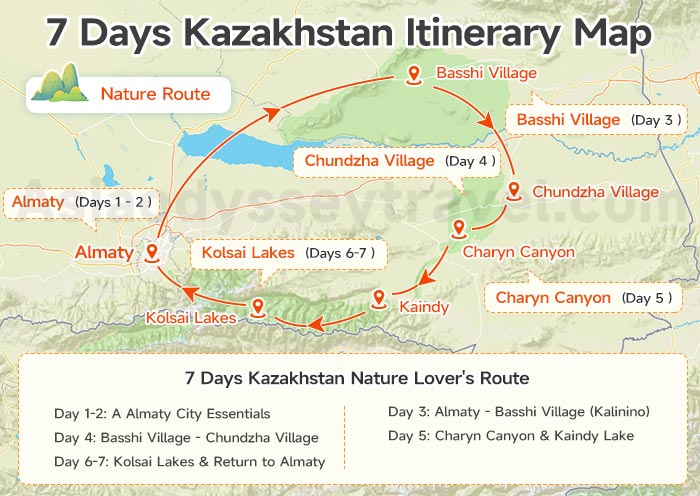
The Golden Triangle Loop (2-Day Circuit)
Pull up the Almaty surroundings map and find the yellow triangle connecting Charyn Canyon, Kaindy Lake, and Kolsai Lakes—this is Kazakhstan's most popular multi-day route. The loop covers 560km.
Day 1: Almaty → Charyn Canyon → Kolsai Lakes (330km, 5-6 hours driving). Charyn delivers the desert canyon drama. And head to Saty. The Golden Triangle map marks Saty as the only guesthouse zone.
Day 2: Kolsai → Kaindy Lake → Almaty (230km, 4-5 hours). You're at Kolsai Lakes—alpine waters at 2,000m surrounded by Tien Shan spruce forests. The first lake sits 10km from Saty village (your overnight base).
Kaindy Lake is why this loop exists—dead spruce trees jutting from turquoise water, perfectly preserved since a 1911 earthquake flooded the valley. The submerged forest creates an eerie, otherworldly scene that looks Photoshopped.
Charyn Canyon to Kolsai Lake Distance & Route: Plan 1 or 2 Days?
How to Navigate This Tourist Map of Almaty
The Almaty surroundings map prioritizes these five destinations (Big Almaty Lake, Medeu-Shymbulak, and the Golden Triangle) because they're reachable without technical climbing skills and offer maximum scenery for minimum effort.
For day trips: Medeu-Shymbulak works with public transport (bus #12 or Yandex taxi). Big Almaty Lake and Charyn Canyon need private vehicles—hire a taxi or join a group tour.
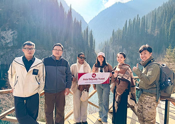
For the Golden Triangle Loop: Group tours are the easiest option. Asia Odyssey Travel organizes Almaty day trips, multi-day Golden Triangle circuits, and extended Kazakhstan tours. We handle mountain transport, hotels and guides so you just show up and explore.
Almaty Metro Map (Subway Map): Line & Stations You Must Visit
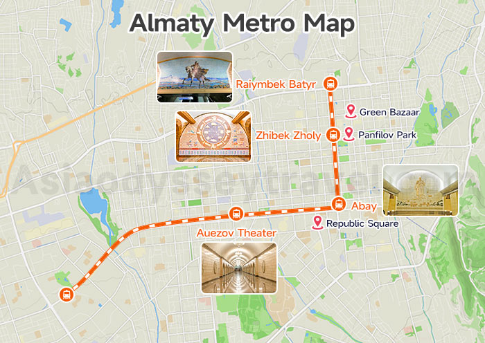
The Almaty metro map shows one operational line running 11 stations across 11km—Central Asia's cleanest subway system and an attraction itself. You'll see Line 1 cuts northeast to southwest through the city core.
Line 1: All 11 Stations
The subway map of Almaty highlights 4 stations you can be stop: Zhibek Zholy (Panfilov Park access), Abay (Kok Tobe connection), Raiymbek Batyr (Green Bazaar), and Auezov Theater. The remaining seven serve local neighborhoods.
| Station Number | Station Name | Nearest Attraction/Function |
|---|---|---|
| 1 | Raiymbek Batyr | Green Bazaar (6-minute walk) |
| 2 | Zhibek Zholy | Panfilov Park, Ascension Cathedral (8-minute walk) |
| 3 | Almaly | Republic Square (10-minute walk) |
| 4 | Abay | Kok Tobe cable car base (12-minute walk) |
| 5 | Baikonur | Residential area |
| 6 | Театр им. Мухтара Ауэзова (Auezov Theater) | Kazakh Drama Theater |
| 7 | Alatau | Residential area |
| 8 | Sairan | Residential area |
| 9 | Moscow | Residential area |
| 10 | Saryarka | Residential area |
| 11 | Moskva | Residential area |
The Stations Worth Visiting (As Attractions)
Soviet-era designers turned these stations into underground palaces. The Almaty subway map marks three stations as architectural highlights.
Zhibek Zholy Station (Silk Road theme). Marble columns with Kazakh yurt-inspired geometric patterns in gold and cream. Curved platform creates symmetrical photo angles—most photographed station.
Abay Station (Literary tribute). Poet Abay's verses carved into granite walls. Soft yellow lighting, bronze bust in central hall. Locals call it the "intellectual station."
Baikonur Station (Space age design). Soviet space-age mosaics—rockets, satellites, cosmic blues and silvers. Retro-futuristic design honoring Kazakhstan's cosmodrome history.
Almaty Airport Map: Location & Transfer to City Center
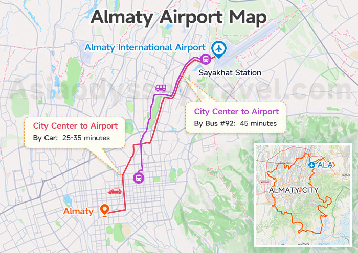
Almaty International Airport (ALA) sits 15km northeast of the city center, a 25-35 minute drive. The Almaty airport map shows one terminal handling all flights.
Transfer options: Bus #92 runs to Sayakhat Station (₸80, 45 minutes, 6am-11pm).
Almaty Transport Map: Central Asia Flights & Border Crossings
The Almaty transport map extends beyond Kazakhstan's borders, showing flight connections across Central Asia and overland routes into neighboring countries.
Whether you're flying between Stans or crossing into Kyrgyzstan by land, Almaty serves as the region's primary gateway.
Almaty Central Asia Stans Flights Map
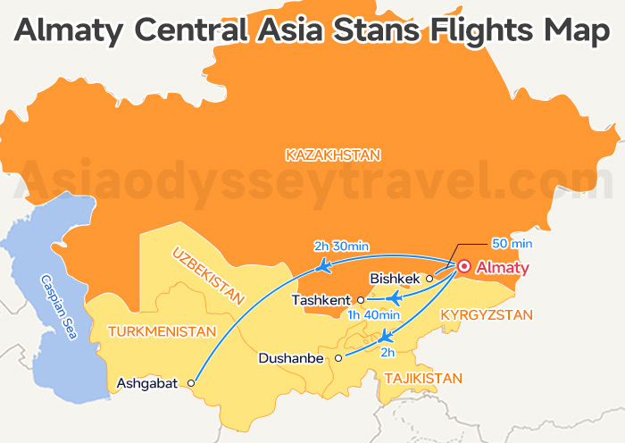
Almaty International Airport (ALA) serves as Central Asia's main hub, connecting all five Stans with daily flights.
The Almaty flights map shows direct routes to Bishkek (50 minutes, multiple daily), Tashkent (1h 40min), Dushanbe (2h), and Ashgabat (2h 30min).
Almaty to Kyrgyzstan Border Map (Land Route)
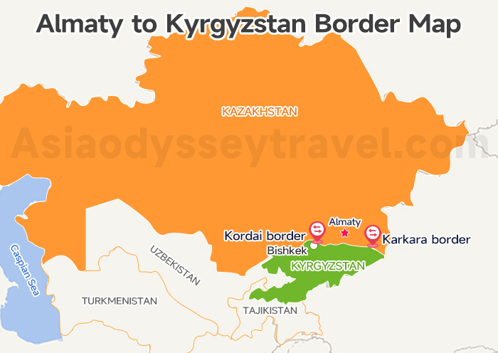
The Almaty border map marks two main crossings into Kyrgyzstan. Kordai border (230km west, 3-4 hours) leads to Bishkek via the A2 highway—most popular route for shared taxis and buses (5 hours total).
Karkara border (300km east, near Charyn Canyon) accesses Karakol and Issyk-Kul Lake, but requires private vehicle. Both crossings open 24/7.
Almaty to Issyk Kul 2026: Via Bishkek (West) or Karakol (East)
Explore Kazakhstan With Asia Odyssey Travel (AOT)
Skip the stress of language barriers and complex logistics. Asia Odyssey Travel handles everything—from professional drivers to English-speaking guides—so you can focus on the "all-round" surprise of Central Asia.
Check out our top-rated options:
- ✅ Kazakhstan Group Tours – The best-value choice. Enjoy 4-star comfort, safety, and authentic experiences in guaranteed small groups (1-16 people).
- ✅ Kazakhstan Tour Packages – Flexible private or group itineraries covering Almaty’s alpine nature (Charyn Canyon, Kolsai Lakes) and Astana’s futuristic architecture.
- ✅ Central Asia Grand Tours – Epic multi-country journeys (up to 26 days) that extend your adventure across the "5 Stans" of the Silk Road.
")


")
 Map 2026: Explore Ashgabat on Map for Location & Sights")
 with Map (2026)")


")
: Tourist Regions, Cities & Surrounding Countries")
 | 2026")