Where is Kazakhstan on the Map? Location in Central Asia
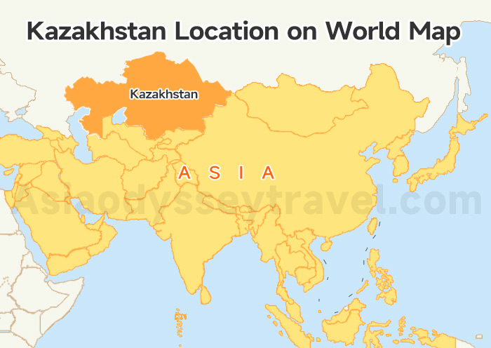
Kazakhstan is located in the heart of Central Asia. When looking at where is Kazakhstan on the map, you'll notice it's squeezed between Russia (north) and China(east).
Look west and you hit the Caspian Sea. South brings three neighbors: Uzbekistan, Kyrgyzstan, and Turkmenistan—the rest of the "Stans."
| Quick Fact | Data |
|---|---|
| Coordinates | 48°N, 68°E (Central Asia) |
| Flight Time | 6.5h from Frankfurt / 5h from Beijing |
| Time Zones | UTC+5 (West) & UTC+6 (East/Almaty) |
| Neighbors | Russia, China, Kyrgyzstan, Uzbekistan |
Kazakhstan Country Map: 17 Regions & Key Tourist Regions
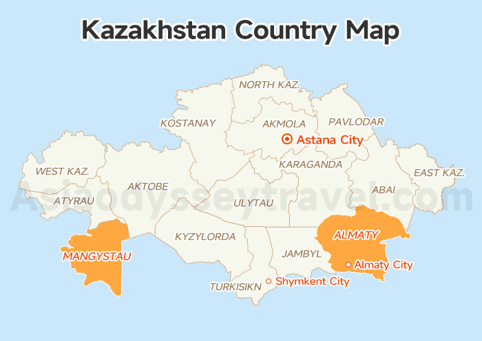
Kazakhstan is the 9th largest country on Earth — 2.7 million km². That's like squashing all of Western Europe into one nation. And on this Kazakhstan map, you'll see it's now divided into 17 provinces (oblasts) plus 3 special cities.
Top 5 Regions on the Map (Where 80% of Tourists Go)
About 80% of tourists only visit 5 regions (the highlighted areas on this map). Those five just have actual tourist infrastructure, English-speaking guides, and things you can't see anywhere else.
These five regions form the core tourist arc on the Kazakhstan map. Everything else? That's for round two (or three).
guides, and things you can't see anywhere else:
| Region (Find It on the Map) | What's There |
|---|---|
| Almaty City (Southeast) | Ski resorts (Shymbulak), urban leisure, food scene, gateway to surrounding nature |
| Almaty Region (Southeast) | Nature adventure hotspot: Charyn Canyon, Kolsai Lakes, Kaindy Lake |
| Astana City (Central) | Business travel, futuristic architecture (Baiterek Tower, Khan Shatyr), MICE tourism |
| Shymkent City (South) | Food capital, Silk Road stopover city |
| Mangystau Region (West Coast) | Fastest-growing tourist region: Caspian resorts (Aktau), Bozjyra Mars landscapes, underground mosques |
Almaty Map 2026: Kazakhstan Almaty Map of City, Metro & Tourist
Astana Map 2026: Tourist Map of Astana City, Metro & Attractions
What About the Other 15 Regions?
On the map, these regions cover 75% of Kazakhstan's territory but see maybe 20% of tourists. Unless you're into extreme trekking, Soviet architecture, or rocket launches, most visitors stick to the Big Five highlighted above.
Northern Belt (Akmola, North Kazakhstan, Kostanay, Pavlodar): Kazakhstan's breadbasket with the country's densest lake clusters and forests. Cool climate, perfect for summer escapes.
Eastern Highlands (East Kazakhstan, Abay): This is Kazakhstan's most "European Alps-like" corner. You can enjoy hardcore hiking, horseback trails and eco-therapy retreats.
Southeast & South (Jetisu, Turkistan, Zhambyl, Kyzylorda): The photographer's paradise. Core Silk Road territory with the richest historical sites and diverse landscapes (deserts, canyons, snow peaks). And you can watch rocket launches at Baikonur Cosmodrome.
Central Heartland (Ulytau, Karaganda): The belly of the Kazakh steppe — vast, sparse, pure nomadic culture experience.
Western Frontier (West Kazakhstan, Atyrau, Aktobe): Geographically spans the Europe-Asia dividing line, unique Cossack history.
Map data updated: February 2026, Administrative divisions reflect 2022 reorganization
Kazakhstan Map with Cities: Airports & How to Get Around
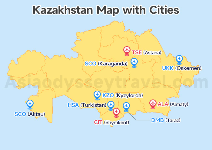
Okay, you've seen the 20 regions on the map above. Now here's the practical question: which cities actually have airports? This Kazakhstan cities map shows the 9 airport hubs you need to know — these are where flights land and your trip starts.
3 Main Gateway Cities with International Airports: Almaty, Astana & Shymkent
Looking at the cities map, three cities stand out with international airports.
These three handle 95% of tourist arrivals. Almaty gets the most international flights (Istanbul, Dubai, Seoul). Astana works if you're doing business or starting up north. Shymkent is the southern gateway near Uzbekistan.
| City | Airport | Gateway To | Flight Time from Almaty |
|---|---|---|---|
| Almaty | ALA | Charyn Canyon, Kolsai Lakes, Big Almaty Lake, ski resorts | — |
| Astana | TSE | Burabay lakes, modern architecture | 1.5 hours |
| Shymkent | CIT | Turkistan UNESCO mosque, Silk Road sites | 1.5 hours |
6 Regional Airport Cities (Domestic Flights)
Find these 5 regional airports connecting to the "Big 3" on the map above — use these if you're going deeper into Kazakhstan. Aktau and Oskemen matter most for tourists — Aktau gets you to those desert Instagram shots, Oskemen is your mountain trekking base.
| City | Airport | Gateway To | Flight from Almaty/Astana |
|---|---|---|---|
| Aktau | SCO | Mangystau desert landscapes, Caspian coast | 3h / 2h40m |
| Oskemen | UKK | Altai Mountains, Lake Markakol | 1.5h / 1.5h |
| Karaganda | KGF | Soviet history museums | 1h45m / - |
| Taraz | DMB | Silk Road ruins | 1h / 1h40m |
| Turkistan | HSA | Yasawi Mausoleum (UNESCO) | 1.5h / 1h45m |
| Kyzylorda | KZO | Baikonur Cosmodrome (rocket launches) | 1.5h / 2h |
Kazakhstan Tourist Map: 15 Must-Visit Places & Attractions
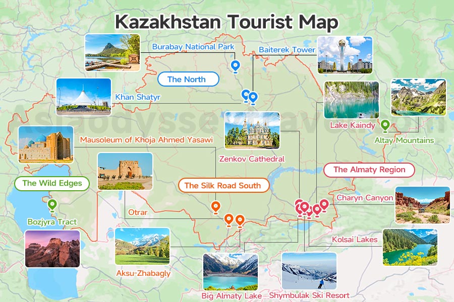
Enough with the logistics—now for the fun part! Pull up this Kazakhstan tourist map, We have highlighted the top 15 sights you actually want to see. Use it to zero in on the national parks and monuments that will make your trip truly unforgettable.
The Almaty Region (The "Big 6")
Start at the bottom right of the map. This is where 90% of tourists spend their time. Around the former capital, the map clusters six essential stops.
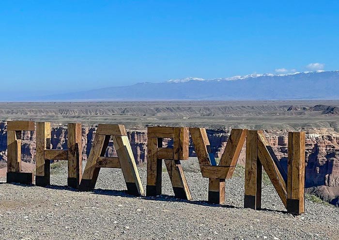
First, you have the "Golden Triangle" of nature: Charyn Canyon (often compared to the Grand Canyon), the deep blue Kolsai Lakes, and the famous sunken forest of Lake Kaindy. These are all reachable by car.
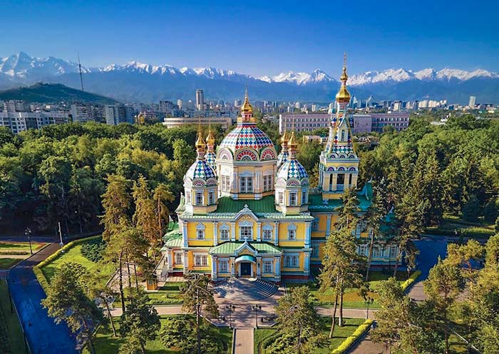
Closer to town, you have Big Almaty Lake high in the mountains and Shymbulak Ski Resort. Inside the city, mark Zenkov Cathedral—it is built entirely of wood without nails.
The Silk Road South (Culture)
Move your finger west along the southern border on the Kazakhstan tourist map. This is the cultural heartland. The absolute must-see here is the Mausoleum of Khoja Ahmed Yasawi in Turkestan.
It is the country’s most iconic building and a UNESCO site. Nearby, you will find the ancient ruins of Otrar and the oldest nature reserve in the country, Aksu-Zhabagly, famous for wild tulips.
The North (Modern & Green)
Look up to the north. The map here is dominated by the capital, Astana.
You need to see the Baiterek Tower (the symbol of the city) and Khan Shatyr, a massive transparent tent with a beach inside. Just a short drive north of the capital is Burabay National Park, often called "Kazakh Switzerland" for its pine forests and lakes.
The Wild Edges (Adventure)
Finally, check the far edges of the tourist map. In the deep West, Bozjyra Tract offers alien, Mars-like landscapes that are becoming Instagram famous. In the far East, the Altay Mountains offer raw, untouched wilderness for serious hikers.
15 Top Places to Visit in Kazakhstan & Things to Do (Map & Itinerary)
Kazakhstan Itinerary Map: 6-Day, 7-Day & 10-Day Routes
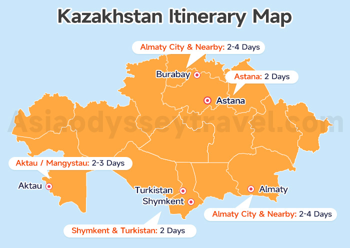
So, how do you connect the dots between your favorite spots? We have provided a Kazakh Itinerary Map that shows the recommended stay time for every region. You can use it to piece together your own trip, just like building blocks.
Or, you can take the shortcut. Check out the three maps below. These are three classic routes refined by Asia Odyssey Travel over five years of local experience. In fact, 80% of travelers in the last five years have chosen to follow these exact paths.
6 Days Kazakhstan Itinerary Map (Almaty Region)
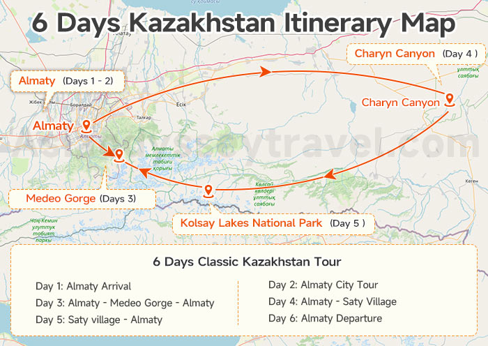
If you are short on time, look at the 6-day route on the map. It stays entirely in the South around Almaty.
You can focus purely on the "Golden Triangle" of nature: Charyn Canyon, Kolsai Lakes, and Lake Kaindy. This is a classic loop, perfect for first time and nature lovers who want to see the most beautiful landscapes without packing and unpacking constantly.
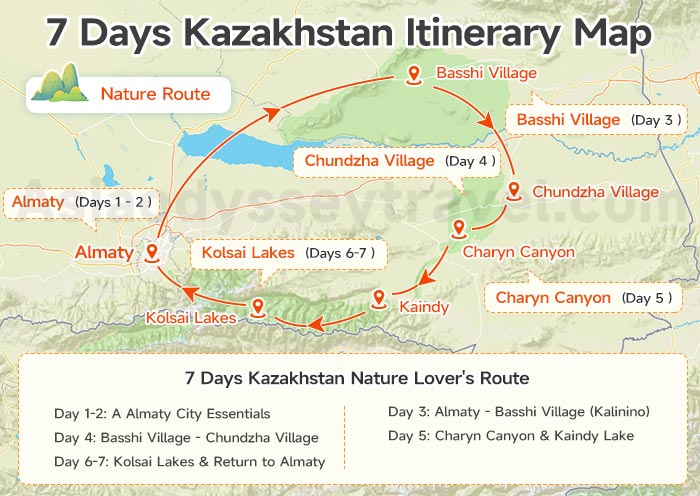
7 Days Kazakhstan Itinerary Map: Almaty & Astana (North & South)
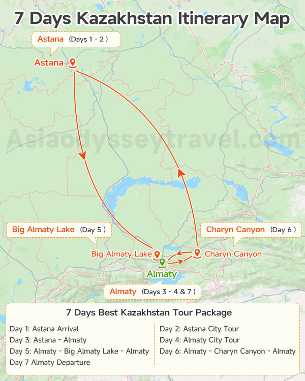
For a complete contrast, the 7-day route is your best bet. It does not just stay in nature; it connects the country's two distinct personalities.
You start in the futuristic north at Astana (seeing the Baiterek Tower and Grand Mosque), then fly south to Almaty for history and mountains. You still get to see Big Almaty Lake and Charyn Canyon.
Kazakhstan 7-Day Itinerary: 3 Routes (Classic, Nature & Culture) + Cost
10 Days Kazakhstan Itinerary Map
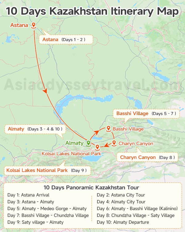
Got more time? The 10-day route is the ultimate adventure on our itinerary map. It starts with the "Dual Capitals" (Astana & Almaty) but then pushes deep into the wild East.
Have a expedition into Altyn Emel National Park to hear the Singing Dune, relax in the Chundzha Hot Springs, and sleep in local villages like Saty. This covers the famous Kolsai Lakes and Kaindy Lake (the sunken forest).
Kazakhstan Train Map: High-Speed Talgo vs. Soviet Lines (How to Book)
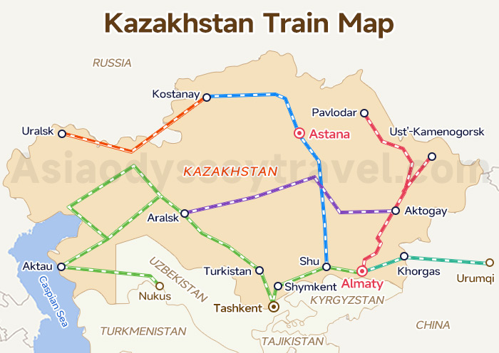
Still exploring your transport options? Take a look at this Kazakhstan Train Map. You will see that the rail network covers almost the entire country.
Unlike in Europe, where trains are often used for short hops, here they are the king of overnight travel. It is a win-win: you save a night's hotel bill and cover the vast steppes while you sleep. Real travel times for top routes:
| Almaty - Astana | Almaty - Shymkent |
|---|---|
| Fast Train (Talgo): ~15 - 16 hours | Fast Train (Talgo): ~10 - 12 hours |
| Soviet Train: 24 hours | Soviet Train: ~16 - 18 hours |
International Connections: The map also highlights routes beyond the border. You can catch trains to Tashkent, Kungrad, and Nukus in Uzbekistan, or head east to Urumqi, China.
A Tip from the Locals: The booking system can be tricky, so follow this Golden Rule: Always book a lower bunk. (Look for odd numbers on the seat map).
Watch out for the stations: Almaty and Astana both have two. In Almaty, make sure your ticket says "Almaty-2"—that is the one right in the city center.
Ready to book? Use the map to plan, then book immediately on Tickets.kz or Railways.kz. Tickets open 45 days in advance.
Map of Kazakhstan and Surrounding Countries (The 5 Stans)
You didn't come all this way just to see one country, right?
In this section, explore the possibilities of combining your trip with other "Stans" in Central Asia. Since a single regional map can get messy, we have broken it down into three specific maps to help you plan your exit strategy.
The "5 Stans" Flight Connection Map
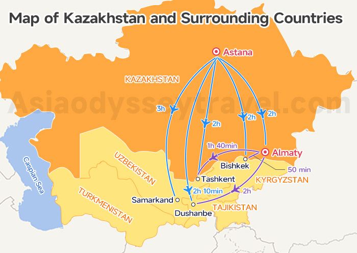
Look at the flight map of Kazakhstan and surrounding countries above. Almaty (ALA) is the primary hub. From here, you can fly directly to Tashkent (Uzbekistan) and Dushanbe (Tajikistan).
The Kazakhstan Kyrgyzstan Connection Map
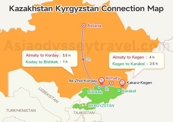
Linking Kazakhstan and Kyrgyzstan is a traveler favorite. You can fly directly to Bishkek from both Almaty and Astana. If you are heading to Bishkek (Capital) overland, the Korday border is your best choice.
If your goal is the hiking trails on the southeast shore of Lake Issyk-Kul, skip the capital and take the Karkara border instead—it is much closer.
Cross Kazakhstan Kyrgyzstan Border (2026): 3 Points, 5 Options
The Kazakhstan Uzbekistan Connection Map
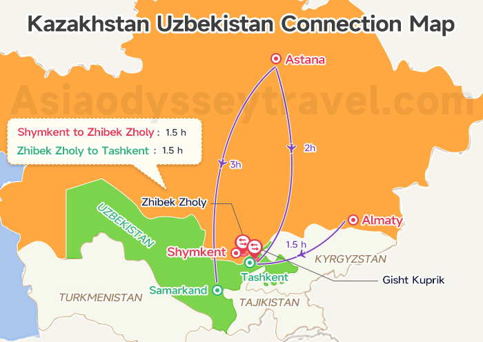
Flying is the most common option. There are flights to Tashkent from both Almaty and Astana, and even a direct route from Astana to Samarkand.
However, if you are already in Shymkent (southern Kazakhstan), don't fly. You can reach Tashkent in just 3–4 hours via the Zhibek Zholy border (not counting customs time).
Uzbekistan–Kazakhstan Border: Name, Distance & Tips
Explore Kazakhstan With Asia Odyssey Travel (AOT)
Skip the stress of language barriers and complex logistics. Asia Odyssey Travel handles everything—from professional drivers to English-speaking guides—so you can focus on the "all-round" surprise of Central Asia.
Check out our top-rated options:
- ✅ Kazakhstan Group Tours – The best-value choice. Enjoy 4-star comfort, safety, and authentic experiences in guaranteed small groups (1-16 people).
- ✅ Kazakhstan Tour Packages – Flexible private or group itineraries covering Almaty’s alpine nature (Charyn Canyon, Kolsai Lakes) and Astana’s futuristic architecture.
- ✅ Central Asia Grand Tours – Epic multi-country journeys (up to 26 days) that extend your adventure across the "5 Stans" of the Silk Road.


")
 Map 2026: Explore Ashgabat on Map for Location & Sights")
 with Map (2026)")


")
: Tourist Regions, Cities & Surrounding Countries")
 | 2026")