Sentosa Location Map: Where Is Sentosa Island on Map?
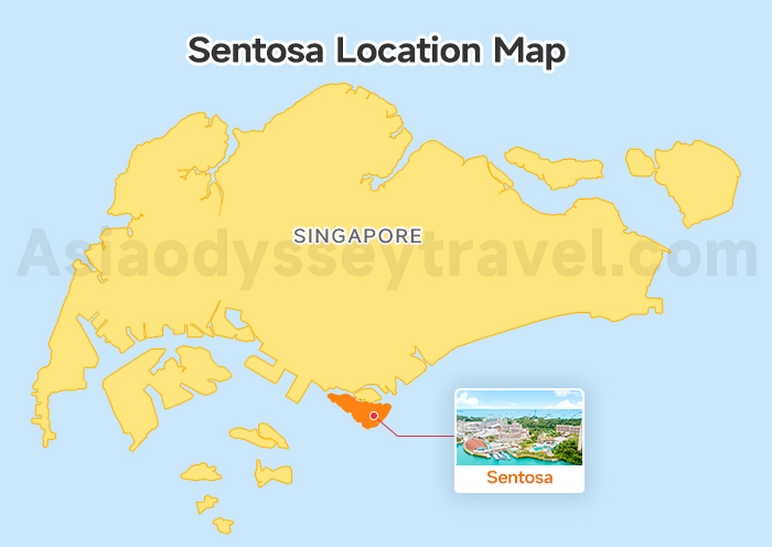
First things first: where is Sentosa Island? The Sentosa Location Map shows you that the island is just minutes away from Singapore's main island, nestled directly off the HarbourFront area.
This proximity means you can travel seamlessly from the city center to the fun in under 15 minutes!
It's located right next to the massive VivoCity shopping mall, which serves as the primary gateway (and transit hub) to Sentosa.
Sentosa Transport Maps: How to Get to & Around Sentosa Island?
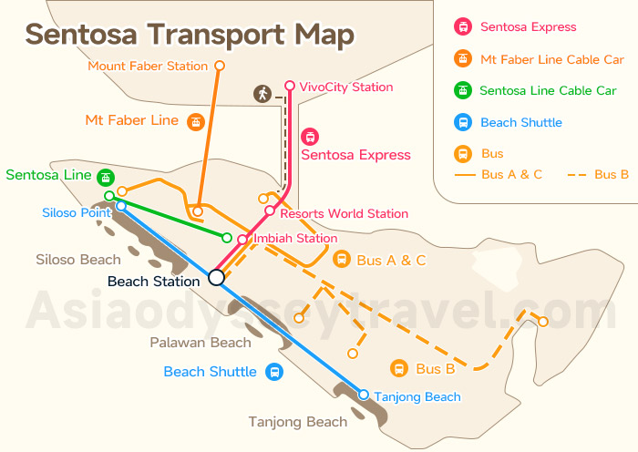
Our Sentosa Transport Map is neatly divided into 2 parts: Gateway Access (getting onto the island from Singapore's mainland) and Internal Mobility (getting around once you're there).
How to Get to Sentosa Island: 3 Transport Routes on Map
As shown on the above Sentosa Transport Map, you have 3 main options for getting onto the island from HarbourFront/VivoCity:
| Route | Cost & Time Data | Why Choose It? |
|---|---|---|
| Sentosa Express (Monorail) | Cost: Approx. S$4 (for entry) | The fastest way to get from the mainland to the heart of Sentosa. The trip from VivoCity Station to Resorts World Station takes about 4 minutes. |
| Mt Faber Line Cable Car | Cost: Higher fare ($35-$50+ round trip) | The most scenic option! It provides fantastic aerial views, and the ride itself takes around 15 minutes from Mount Faber Station to Sentosa Station. |
| Sentosa Boardwalk | Cost: Free (or a nominal entry fee, depending on promotions) | The budget-friendly and leisurely route. The walk from VivoCity to the Sentosa entrance takes about 15 minutes—perfect for a morning stroll. |
We include the Mount Faber Line Cable Car fare in all our guided Singapore tours. Contact Asia Odyssey Travel (Singapore) to book your trip to Sentosa Island!
Once you've arrived, good news: all internal transportation on the island is free! Our Sentosa Transport Map guide tells you exactly which vehicle to grab for getting around Sentosa.
Sentosa Express Map (The Monorail)
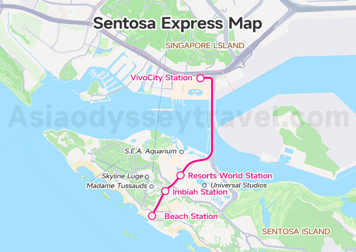
This is the island's fastest spine for major zone-to-zone travel. The Sentosa Express Map shows its route starting from the VivoCity Station on the mainland and hitting 3 main island stations:
Resorts World Station: Perfect for Universal Studios, S.E.A. Aquarium, and the RWS hotels.
Imbiah Station: Ideal access for Skyline Luge, Madame Tussauds, and the SkyHelix.
Beach Station: The main transfer hub linking the Sentosa Express to the Beach Tram, buses, and the drop-off for Wings of Time.
Sentosa Cable Car Map: Mount Faber Line & Sentosa Line
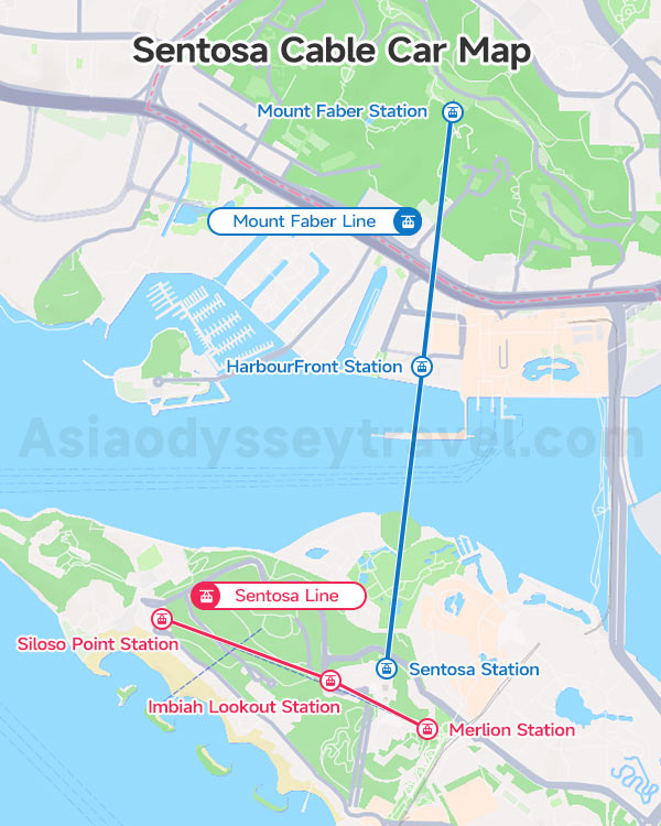
The cable car system isn't just transport—it's an attraction offering stunning views! It operates on 2 distinct lines:
Mount Faber Line Cable Car (Mainland to Island): This is the primary access route that brings you from mainland Singapore (starting at Mount Faber Peak) right onto Sentosa Island. The entire line takes 15 minutes one way.
☞ Stops: Mount Faber Station → HarbourFront Station → Sentosa Station.
Sentosa Line Cable Car (Island Internal): This line allows you to hop between key attractions along the western half of Sentosa. It's free to ride this line if you have a valid ticket for the Mount Faber Line.
☞ Stops: Merlion Station → Imbiah Lookout Station → Siloso Point Station.
Sentosa Beach Tram Map (The Beach Shuttle)
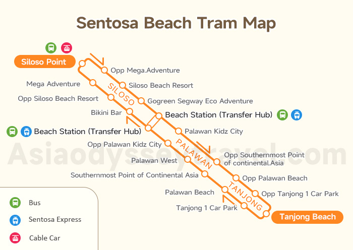
The Sentosa Beach Tram Map details the exclusive, circular route along the south coast, making beach-hopping a breeze. It has dedicated stops at:
Beach Station: Transfer hub (connects to Express Monorail).
Siloso Beach: The lively, west-end party zone.
Palawan Beach: The famous Southernmost Point.
Tanjong Beach: The chill, east-end resort vibe.
Sentosa Bus A, B & C Route Map
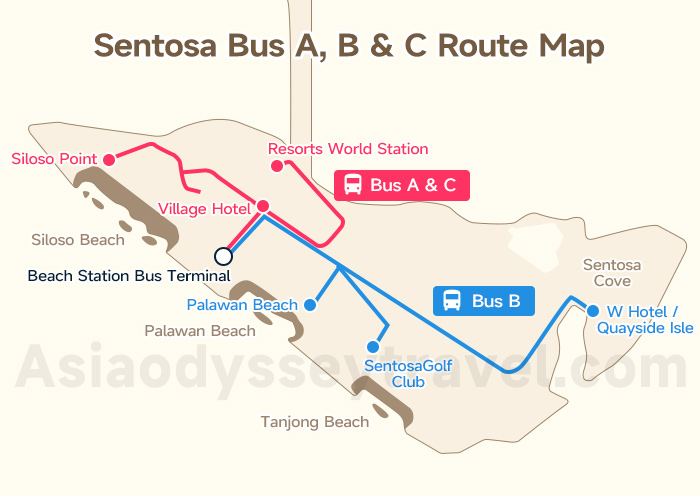
The free buses serve specific routes to connect major zones and hotels, covering areas the monorail and tram miss.
Bus A: Links the main resort area (Resorts World Sentosa) to the beach area and the attractions at Siloso Point, starting and ending at Beach Station.
Bus B: Connects Beach Station to the exclusive residential and lodging area of Sentosa Cove.
Bus C: A vital connection that runs between Beach Station and the mainland's VivoCity shopping mall (near HarbourFront MRT).
Sentosa Walking Trail Map: Sentosa Imbiah Trail & Coastal Trail
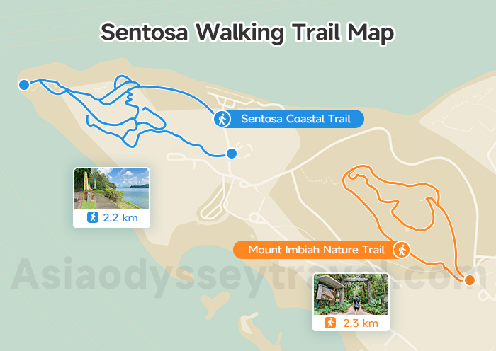
In case you want to explore Sentosa Island on foot, I have 2 shaded paths for you, which are shown on this Sentosa Walking Trail Map.
Mount Imbiah Nature Trail: Forget the crowds and explore Sentosa's lush interior. This is a quiet, forested loop winding through Mount Imbiah, giving you a refreshing dose of tropical greenery. (Approx. 2.3 km).
Sentosa Coastal Trail: For a land-and-sea adventure, tackle the Coastal Trail! This 2.2 km route is a history lesson and nature walk rolled into one, stretching from the tunnels of Fort Siloso to the untouched Tanjong Rimau shore.
Sentosa Attraction Map: Beaches, Themed Parks & History Site
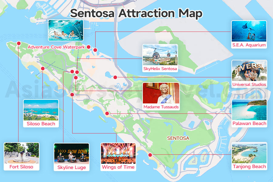
The official Map of Sentosa Attractions features over 30 sites, but here are the must-go spots you should prioritize when planning your day:
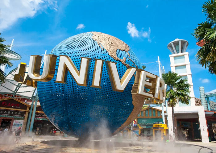
- Universal Studios Singapore (USS)
Located right at the start of the Resorts World Sentosa (RWS) zone, this is pure movie magic! You'll step into 7 different themed worlds, riding roller coasters and 3D adventures.
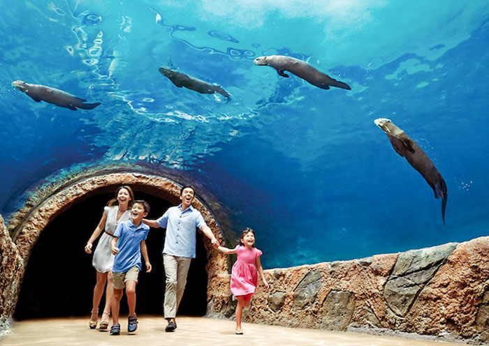
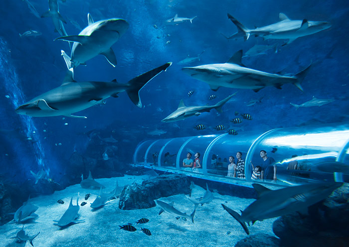
- E.A. Aquarium
Still in the RWS zone, this is your serene chill-out spot. Dive into the massive Open Ocean Habitat—it's like peering into the deepest part of the sea, surrounded by tens of thousands of creatures. A perfect, calming break from the heat.
- Adventure Cove Waterpark
Also in RWS, this is where you beat the heat! The park is packed with high-speed water slides and even features a unique hydro-magnetic coaster.
- Skyline Luge Sentosa
Head up to the Imbiah Lookout zone for this one. You'll hop into a part-sled, part-go-kart machine and zip down four different tracks. It's exhilarating, competitive fun, and totally worth the scenic chairlift ride back up!
- SkyHelix Sentosa
A gentle thrill also in the Imbiah Lookout zone. This open-air gondola slowly spirals you up 79 meters. It's not fast, but the 360-degree panoramic views are stunning—the perfect spot for golden hour photos.
- Madame Tussauds
Tucked away in the Imbiah Lookout area. Get ready to rub shoulders with global celebrities and historical icons (in wax, of course!). It's an interesting place for fun, interactive photos and movie sets.
- Wings of Time
Find this spectacle down at the Siloso Beach/Beach Station. It's the grand finale to any day, a breathtaking combination of water, laser, fire, and music set against the open sea. Don't miss this iconic night show!


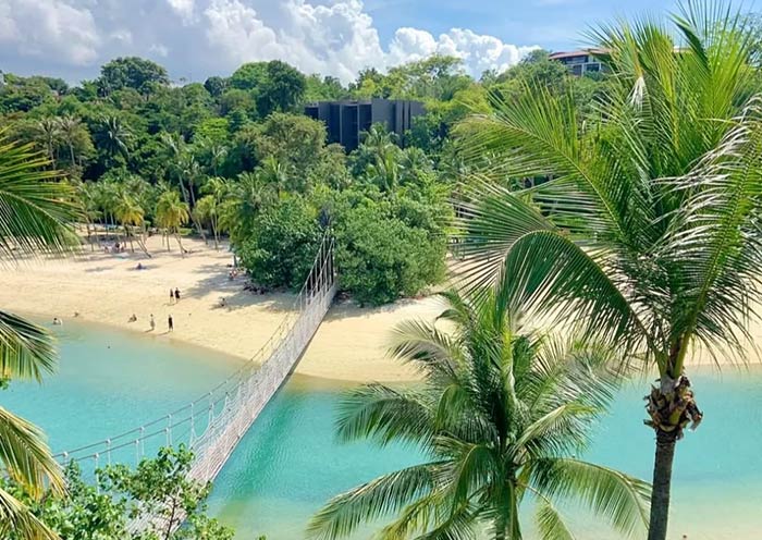
- Siloso Beach
The party hub on the West end of the Beach Zone. This is where the action is! Think beach bars, volleyball, music, and easy access to water sports.
- Palawan Beach
The iconic postcard shot in the Central Beach Zone. Walk across that famous suspension bridge to the Southernmost Point of Continental Asia. It's super family-friendly and a must for that classic Sentosa photo.
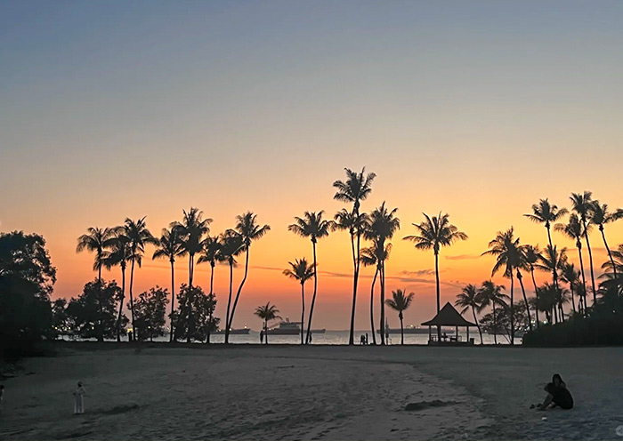
- Tanjong Beach
Found at the East end of the Beach Zone. If you need quiet, sophistication, and relaxation, this is your spot. It's laid-back, tranquil, and home to some of the island's best beach clubs.
- Fort Siloso
Located at Siloso Point (accessible via the beach tram). History buffs, this one's for you! Explore Singapore's only preserved coastal fort, complete with old tunnels and battlements, plus a great skywalk with sea views.
Sentosa Island Tourist Map: Travel Routes on Sentosa Map
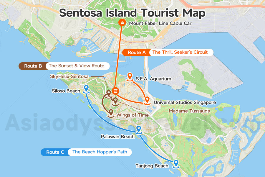
Use the Sentosa Island Tourist Map to follow these optimized paths, ensuring you waste zero time switching zones!
▶ Route A: The Thrill Seeker's Circuit (RWS Focus)
Goal: Maximize theme park rides and speed (perfect for a Day Trip).
Path: Mount Faber Line Cable Car → Universal Studios Singapore (USS) → S.E.A. Aquarium.
Tip: Everything is clustered around the Waterfront Station (RWS).
▶ Route B: The Sunset & View Route (Imbiah Lookout Focus)
Goal: Explore the hills and catch evening views (Deep Exploration half-day/evening).
Path: Madame Tussauds → SkyHelix Sentosa → Wings of Time.
Tip: Use the Cable Car/Escalators to connect attractions efficiently.
▶ Route C: The Beach Hopper's Path (Coastal Focus)
Goal: Experience all three distinct beaches in one day (a different kind of Day Trip).
Path: Siloso Beach → Palawan Beach → Tanjong Beach.
Tip: Rely solely on the Beach Tram and note where essential facilities are located.
Sentosa Hotel Map: Main Accommodation Zones
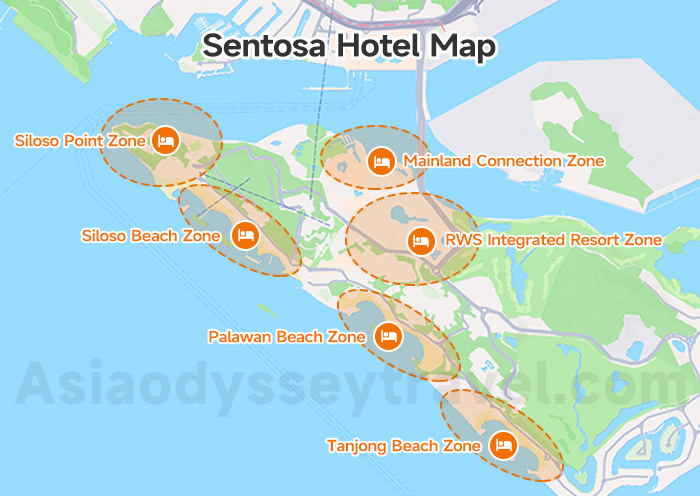
The Sentosa Hotel Map is best understood by focusing on the 3 main lodging areas.
1. RWS Integrated Resort Zone: Focus on the convenience of hotels located within the main entertainment complex (premium access to USS, the Aquarium, and dining).
2. Beachfront & Siloso Point Zone: Focus on lodging areas that offer direct beach access and are ideal for relaxation and quieter stays.
3. Mainland Connection Zone: Highlight hotels closest to the exit/entrance, offering easy access back to VivoCity and mainland Singapore MRT.
Grab Sentosa Maps and Explore with us at Asia Odyssey Travel
With a better understanding of the Singapore Sentosa Map, you are ready to explore! Use this knowledge to customize your route and make sure your trip is fun and relaxing.
Ready to book the perfect itinerary? As ASIA ODYSSEY TRAVEL SINGAPORE PTE. LTD., we're your Singapore-based experts who live and breathe Singapore travel!
We specialize in crafting seamless themed experiences, whether you're looking for a Singapore Family Tour, or specialized trips like a Singapore Tour from Thailand or a Singapore Tour from the Philippines.
Let us handle the logistics so you can simply enjoy the fun of Sentosa!