Xishuangbanna Maps at a Glance: Which Map to Use for Your Trip
The table below lists every Xishuangbanna tourist map in this guide. If you are short on time, start with the Attractions Map and the Planning Map — together they answer the two most common questions: "What is there to see?" and "How do I organize my days?"
| Map | What It Shows | Best For |
|---|---|---|
| Xishuangbanna China Map | Location within China and Yunnan | Understanding where Xishuangbanna is |
| Attractions Map | All major sights across three zones | Getting a full overview of what to see |
| Planning Map | City center, north, south & east routes | Organizing your daily itinerary |
| Detailed Maps | Wild Elephant Valley, Botanical Garden & Dai villages | Navigating inside top attractions |
| Food Map | Dai cuisine restaurants and night markets | Finding the best local food |
| Travel Map | Airports, train stations, hotels & distances | Arranging transport and accommodation |
| Itinerary Map | 5-day Kunming & Xishuangbanna route | Following a tested day-by-day plan |
Where Is Xishuangbanna Located? Xishuangbanna China Map
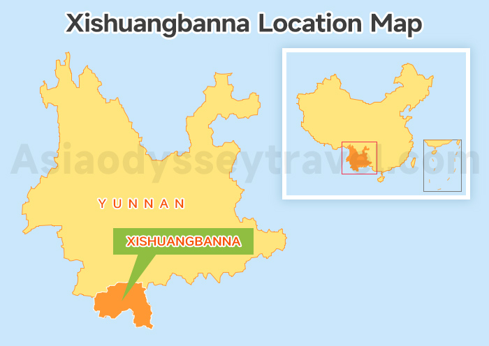
Where exactly is Xishuangbanna? The Xishuangbanna China map above shows its location at a glance. Xishuangbanna sits in the far southwest corner of China, in southern Yunnan Province. Its approximate center coordinates are 21.97°N, 100.76°E.
That puts it at roughly the same latitude as Hawaii. Temperatures stay warm all year round, with averages ranging from 18°C to 30°C depending on the season. This makes Xishuangbanna one of the few places in China where you can find tropical rainforests, wild Asian elephants, and lush river valleys.
On a wider regional map, Xishuangbanna borders Myanmar to the west and Laos to the south. The Mekong River — known locally as the Lancang River — flows right through Jinghong, the capital city of the region.
Most travelers use Jinghong as their base. It is the main city in the area and sits about 530 km from Kunming, the capital of Yunnan Province. Today, a high-speed train connects Kunming to Xishuangbanna in just about 3.5 hours.
Xishuangbanna Attractions Maps: 3 Main Toursit Areas + Planning Map
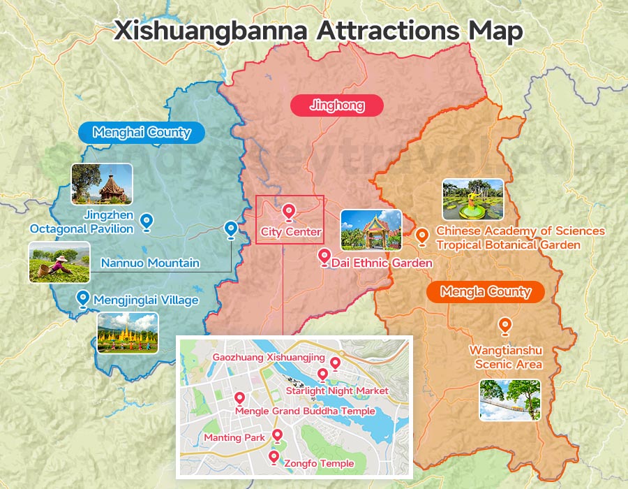
It's time to explore what makes this tropical paradise worth visiting. In this section, we provide 2 Xishuangbanna Attractions maps to help you get oriented.
The first map shows all the top attractions across Xishuangbanna's three main areas — Jinghong City, Mengla County, and Menghai County. It gives you a big-picture view of where everything is.
The second map is a planning map. It groups the most popular attractions by route so you can easily build your own 2- to 5-day itinerary.
Jinghong: Most Visited Area for First-Time Visitors
On a Xishuangbanna attractions map, Jinghong City is the easiest area to understand and the most practical base for a first trip.
The main sights in the city center include Gaozhuang Xishuangjing, Starlight Night Market, Manting Park, Zongfo Temple, Mengle Grand Buddha Temple, and Dai Ethnic Garden.
About 30 to 50 minutes north of the city center by car, you will find three well-known nature attractions: Wild Elephant Valley, Primitive Forest Park, and Jinuo Mountain Village. Most visitors spend 2 to 3 days exploring Jinghong and the surrounding area.
Mengla County: Best Day Trip for Families
Mengla County lies east of Jinghong and is home to two standout attractions: the Chinese Academy of Sciences Tropical Botanical Garden and the Wangtianshu Scenic Area.
The Botanical Garden is one of the most family-friendly spots in Xishuangbanna. It is also one of the largest botanical gardens in China, with over 13,000 plant species spread across a beautiful river-island setting.
Easy walking paths, plant collections from around the world, and a peaceful atmosphere make it a great place for all ages. It takes about 1.5 hours to drive from Jinghong, making it a comfortable day trip.
Wangtianshu is famous for its treetop walkway, which hangs 36 meters above the rainforest floor. It is about 3 hours from Jinghong by car and requires a full day.
Menghai County: Best for Tea Culture and Scenic Villages
Menghai sits to the west of Jinghong. It is better suited for travelers interested in tea culture, mountain scenery, and quiet village life rather than city sights.
Key attractions include Nannuo Mountain, an important Pu'er tea mountain; Jingzhen Octagonal Pavilion, a culturally significant Dai Buddhist structure; and Mengjinglai Village, a well-preserved Dai village near the Myanmar border.
Menghai is best for travelers with more time — usually those staying five days or longer in Xishuangbanna who want to go deeper beyond the classic highlights.
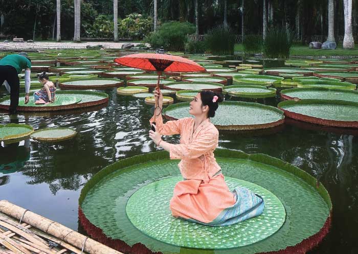
12 Best Xishuangbanna Attractions 2026: Dai Villages & Water Festival & More
Xishuangbanna Planning Map: City Center, North, South & East Routes
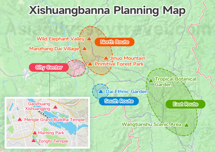
This Xishuangbanna planning map divides the most popular attractions into four color-coded zones. It helps you plan your trip in a smooth and logical way.
The idea is simple: spend one day on the city center sights, then use the north, south, and east routes as separate half-day or full-day trips.
City Center (walkable or short taxi ride): Gaozhuang Xishuangjing, Manting Park, Zongfo Temple, and Mengle Grand Buddha Temple. You can easily cover all of these in one day. Starlight Night Market fills your evening.
North Route (30–50 minutes from Jinghong): Wild Elephant Valley, Primitive Forest Park, Jinuo Mountain, and Manzhang Dai Village. Pick one or two for a half-day or full-day trip. Wild Elephant Valley and Manzhang pair well together.
South Route (30 minutes from Jinghong): Dai Park in Ganlanba and Manyuan Village. A relaxed half-day trip focused on Dai culture, traditional pottery, and riverside village scenery.
East Route (1.5–3 hours from Jinghong): Tropical Botanical Garden and Wangtianshu Scenic Area. Plan a full day for the Botanical Garden alone, or two days if you also want to visit Wangtianshu.
Most first-time visitors stay 3 to 4 days in Xishuangbanna and follow a simple pattern: Day 1 in the city center, Day 2 on the north or south route, and Day 3 at the Botanical Garden. This planning map makes that structure easy to see at a glance.

6 Days Dali Lijiang Tour with Shaxi Ancient Town - Timeless Yunnan
Dali - Shaxi - Lijiang
Detailed Maps: Wild Elephant Valley, Botanical Garden & Dai Villages
Now you have a good idea of how to plan your Xishuangbanna trip. But before you go, here are three detailed maps for the attractions that are large enough to need one.
The first two cover Wild Elephant Valley and the Tropical Botanical Garden — both are big sites where a map really helps you find your way around.
The third is a Dai village map for the Jinghong area. If you want to experience authentic Dai culture, this one is a must-have.
Wild Elephant Valley Map & Walking Route
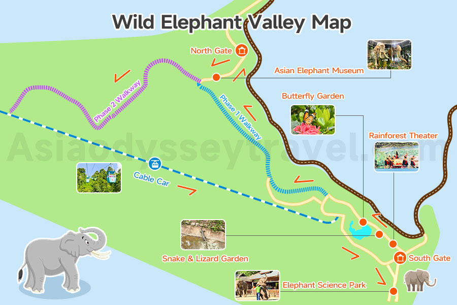
Wild Elephant Valley is about 48 km north of Jinghong, roughly a 50-minute drive. Direct shuttle buses run from Gaozhuang to the valley. This is a nature reserve where wild Asian elephants roam freely through the rainforest. Visitors watch them from elevated walkways and observation platforms.
As you can see from the map, the scenic area has three main sections.
- The South Gate is the main activity zone. It includes the Elephant School, Rainforest Theater, Butterfly Garden, and Orchid Garden.
- In the middle, a sky walkway and cable car connect the two ends.
- The North Gate leads to the Phase 2 elevated elephant-viewing walkway, where your chances of spotting wild elephants are highest. The Elephant Museum is also located here.
North Gate → Asian Elephant Museum → Phase 2 Walkway (best chance to see wild elephants) → Cable Car → Elephant Science Park → Rainforest Theater → Snake & Lizard Garden → Butterfly Garden → Phase 1 Walkway → North Gate.
Elephants avoid the heat. You are more likely to see them early in the morning or around 5 p.m.
Chinese Academy of Sciences Tropical Botanical Garden Map
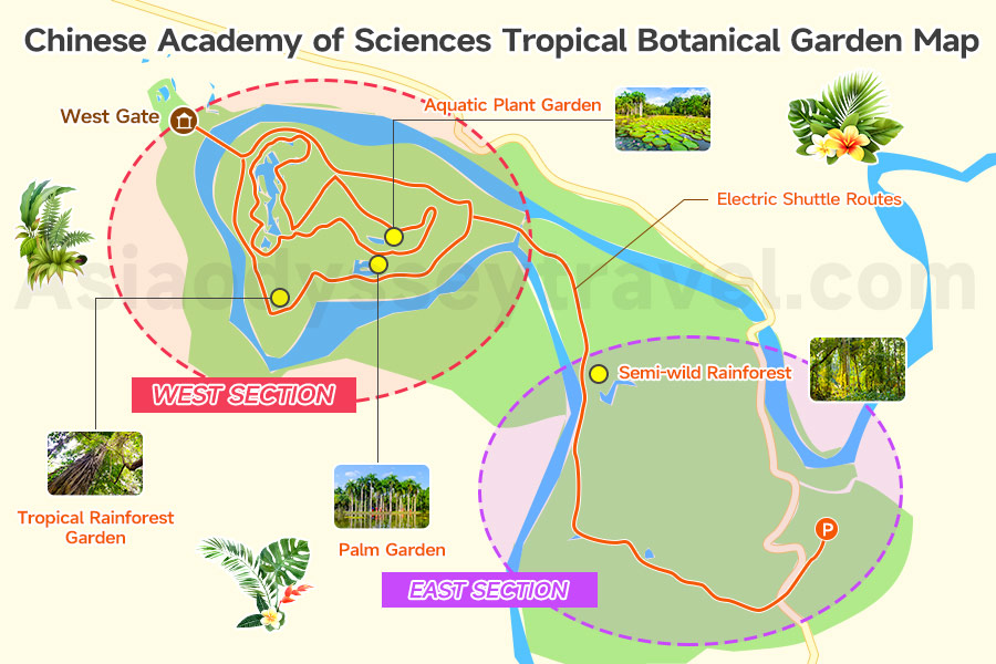
The Xishuangbanna Tropical Botanical Garden is one of the most beautiful gardens in China and a highlight for families and nature lovers. It sits on a peninsula in Menglun, Mengla County, surrounded by the Luosuo River, about 75 km east of Jinghong. The garden covers around 1,100 hectares.
The garden is divided into two parts.
- The West Section features themed gardens, including a tropical rainforest garden, a palm garden, an aquatic plant garden, and a beautiful lotus pond. This is the most visited area and takes 2 to 3 hours to explore on foot.
- The East Section is a larger, semi-wild rainforest — perfect for visitors who enjoy hiking and have extra time.
Our Botanical Garden map shows the full layout of the garden, with a detailed view of the West Section attractions and electric shuttle routes.
If you only plan to visit the West Section, you don't really need the electric shuttle. Just start from the West Gate and walk toward the East Gate. However, if you are traveling with young children or elderly family members, the shuttle route on this map will be very helpful.
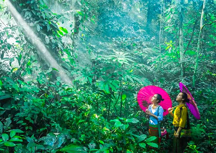
Xishuangbanna Dai Villages Map: Best Villages to Visit
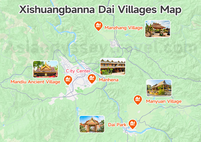
Dai villages have always been one of the highlights of Xishuangbanna. Here you can learn about Dai homes, daily life, traditions, and handicrafts. On this map, we have marked the most recommended Dai villages near Jinghong.
| Village | Distance from City | Ticket | Tourist | Key Features | Best For |
|---|---|---|---|---|---|
| Dai Park | 30–60 min | ¥80 | High (scenic area) | Five villages in one area, water splashing, food, full cultural experience | First-time visitors, families, lively atmosphere |
| Manyuan Village | 45–60 min | Free (Mushroom House ¥20) | Low | Untouched old village, beautiful setting, mushroom-shaped houses | Quiet getaway, photography, cultural depth |
| Manzhang Village | 40 min | Free | Low to medium | Rich in intangible cultural heritage, riverside farmland setting | Families with kids, handicrafts, slow travel |
| Mandiu Ancient Village | 15 min | Free | Very low | Extremely authentic, close to airport, few tourists | Culture lovers, short stop, quiet escape |
| Manhena | In the city | Free | Medium (trendy cafés) | Small village within the city, Dai-style houses with coffee shops | Short on time, easy city stop |
Manzhang and Manyuan are ideal for a half-day visit paired with nearby attractions on the same route. Dai Park is the most developed and tourist-friendly option, with organized cultural performances.
Xishuangbanna Food Map: Dai Cuisine & Night Markets
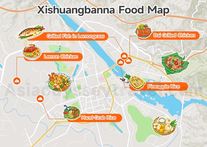
Dai cuisine is one of the biggest reasons to visit Xishuangbanna. It is unlike any other Chinese regional cooking — sour, spicy, herbal, and often grilled over open flame. If you enjoy Southeast Asian food, you will feel right at home here.
| Dish | What It Is | Where to Eat |
|---|---|---|
| Grilled Fish in Lemongrass (香茅草烤鱼) | Whole fish stuffed with lemongrass and herbs, grilled in banana leaf | No.3 Mandou Road, Jinghong |
| Dai Grilled Chicken (烤鸡) | Free-range chicken grilled with local spices | No.176 Xuanwei Avenue, Jinghong |
| Pineapple Rice (菠萝饭) | Sticky rice steamed inside a hollowed pineapple | No.113 Jiangbeimandou, Jinghong |
| Hand-Grab Rice (傣味手抓饭) | A platter of rice, grilled meats, and vegetables eaten by hand | No.44 Manjingbao, Jinghong |
| Lemon Chicken (柠檬鸡) | Cold chicken dressed in fresh lime juice and herbs | Manla Village, Jinghong |
The Starlight Night Market at Gaozhuang is the most popular food destination and worth visiting at least once. It opens around 6 PM and stays lively until late.
For a more local experience with fewer crowds, try the Riverside Night Market or ask your hotel to recommend a nearby Dai barbecue spot — some of the best food in Xishuangbanna comes from small, no-name roadside restaurants that do not appear on any app.
Yunnan Food: 20 Must-Try Yunnan Dishes & Traditional Cuisine (2026 Guide)
Xishuangbanna Travel Map: Airports, Railway Stations & Best Areas to Stay
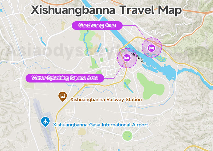
By now you have a good understanding of what to see and eat in Xishuangbanna. This travel map fills in the rest. It shows the locations of the airport and train station, their distances to Gaozhuang, and highlights the two best areas to stay — marked in color blocks.
Xishuangbanna has one airport and one main train station, both located in Jinghong.
- Xishuangbanna Gasa International Airport (JHG) is about 9 km from Gaozhuang. A taxi takes around 20 minutes. Public buses (Line 4 and Line Z88) go there directly but take about 1 hour.
- Xishuangbanna Railway Station is just 1 km from the airport. It sits on the China–Laos Railway line. From here, public buses (Lines K1, Z88, and 4) take about 35 minutes to Gaozhuang. A taxi takes around 20 minutes.
Where to Stay in Xishuangbanna: 2 Best Areas
| Gaozhuang Area | Poshuiguangchang (Water-Splashing Square) Area | |
|---|---|---|
| Vibe | Busy, touristy, lively at night | Quieter, more local, laid-back |
| Food | Huge variety — night market, snack stalls, trendy restaurants all within walking distance | Local restaurants with fair prices |
| Hotels | Lots of guesthouses and hotels, good value | Good value, generally quieter at night |
| Transport | Direct shuttle buses to major attractions like the Botanical Garden | Convenient public transport options |
| Downsides | noisy at night due to the night market crowds | Fewer nightlife options nearby |
| Best For | Short trips, first-time visitors | Families, elderly travelers, budget-conscious visitors |
If your trip is short and you don't want to spend time figuring out logistics, Gaozhuang is the easier choice. If you have more time or prefer a local feel, the Water-Splashing Square area is worth considering.
Getting Around Xishuangbanna: Distances & Transport Between Attractions
| From Jinghong To | Distance | Driving Time |
|---|---|---|
| Wild Elephant Valley | 48 km | 50 min |
| Primitive Forest Park | 25 km | 30 min |
| Jinuo Mountain | 40 km | 40 min |
| Dai Park (Ganlanba) | 27 km | 30 min |
| Tropical Botanical Garden | 70 km | 1.5 hours |
| Wangtianshu Scenic Area | 170 km | 3 hours |
| Nannuo Mountain | 30 km | 40 min |
Suggested 5-Day Kunming & Xishuangbanna Itinerary Map
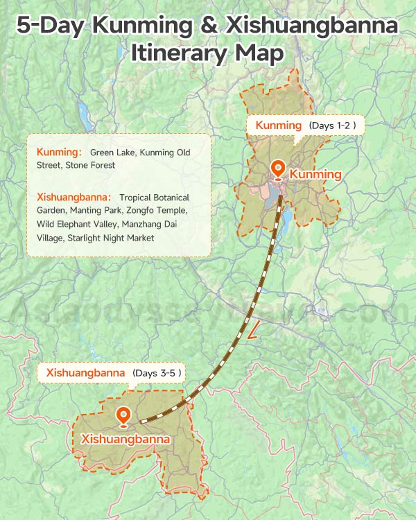
This is the itinerary our team recommends most often to first-time visitors. It combines the highlights of Kunming with the best of Xishuangbanna in 5 days.
| Day | Route | Highlights |
|---|---|---|
| Day 1 | Kunming Arrival | Airport pickup, hotel check-in, free time to explore Green Lake or Kunming Old Street |
| Day 2 | Kunming → Xishuangbanna | Morning visit to Stone Forest, afternoon high-speed train to Jinghong (3.5 hrs) |
| Day 3 | Xishuangbanna | Tropical Botanical Garden (day trip), return for Manting Park and Zongfo Temple in the late afternoon |
| Day 4 | Xishuangbanna | Wild Elephant Valley in the morning, Manzhang Dai Village in the afternoon, Starlight Night Market in the evening |
| Day 5 | Xishuangbanna Departure | Free morning, hotel check-out, airport or station transfer |
The Stone Forest is about 80 km east of Kunming and takes 1.5 hours to reach. With a 2–3 hour visit and a transfer to the railway station, this day is tightly scheduled. If you prefer a relaxed pace, consider visiting the Stone Forest on Day 1 afternoon instead, or skip it and take an earlier train to Jinghong.
If you can extend to 7 days, we recommend adding Menghai County — Nannuo Mountain for tea culture and Mengjinglai Village for a quieter Dai village experience. Our team at Asia Odyssey Travel can customize this itinerary to match your interests and pace. Contact us now!
Kunming to Xishuangbanna Train (High Speed): Schedules, Tickets & Price
5 Days South Yunnan Tour: Kunming to Xishuangbanna by High Speed Train
Kunming - Xishuangbanna
Plan Your Custom Xishuangbanna Trip with Asia Odyssey Travel
Xishuangbanna is a magical mix of tropical nature and unique Dai culture. This complete Xishuangbanna map guide gives you all location, attraction, transport, stay, food, and itinerary info you need.
If you want a hassle-free private tour, custom itinerary, or reliable transport, our team at Asia Odyssey Travel can help. We craft personalized trips to let you enjoy Xishuangbanna's beauty stress-free.
Start planning your unforgettable Xishuangbanna adventure today!
")
")
")