Thailand Location Map: Where Is Thailand on Map?
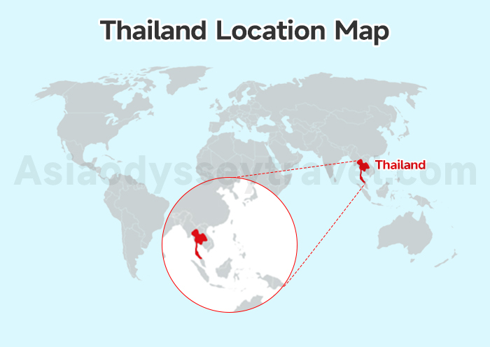
Where is Thailand located? Our handy Thailand Location Map shows you exactly where this amazing country is.
When you look at the big world map, you'll find us sitting comfortably in Asia, right above the equator between latitudes 5° and 21° N, serving as a 24-hour flight hub connecting the West to the East.
If you zoom into Southeast Asia, you'll notice we're smack bang in the center—like the "Heart" of the region! Because we share borders with Myanmar, Laos, Cambodia, and Malaysia, it's a perfect spot for your Asian adventure to begin!
Thailand Tourist Map: Top Attractions & Iconic Landmarks
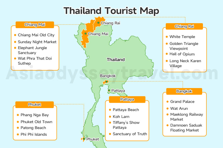
Now that you've found us on the globe, let's look at where the fun is happening.
I have clustered Thailand's top attractions into 4 main zones: the Cosmopolitan Center (Bangkok & Pattaya), the History Belt (Ayutthaya), the Cultural North (Chiang Mai & Chiang Rai), and the Tropical South (Phuket and Krabi).
To help you narrow down your "must-sees," we've marked the top landmarks on this Thailand Tourist Map. As you can see, there's so much to explore!
The Cosmopolitan Center (Bangkok & Pattaya)
| Attractions | Location (GPS) | Highlights |
|---|---|---|
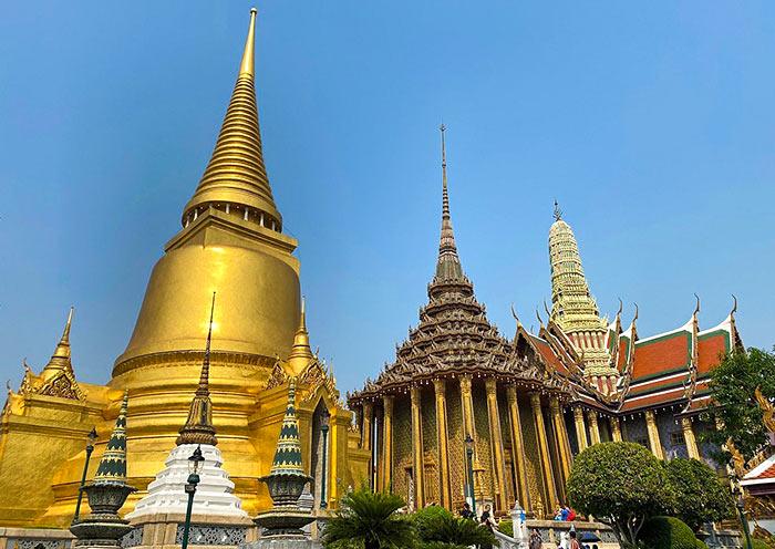
| Grand Palace | Bangkok (13.7500° N, 100.4913° E) | Right in the heart of Bangkok. Former royal residence with amazing architecture. |
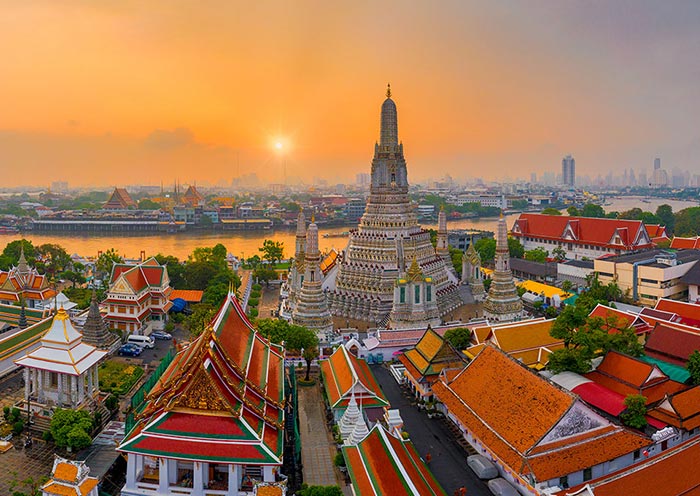
| Wat Arun | Bangkok (13.7437° N, 100.4889° E) | Over by the Chao Phraya River. This temple is stunning, especially at sunrise or sunset. |
| Maeklong Railway Market | Samut Songkhram (13.4075° N, 99.9989° E) | 1.5h from Bangkok. A unique market located directly on active train tracks. |
| Damnoen Saduak | Ratchaburi (13.5181° N, 99.9602° E) | 1.5h from Bangkok. Experience traditional trading on a wooden boat. |
| Pattaya Beach | Pattaya (12.9352° N, 100.8819° E) | Right in the city center. Vibrant beach with nightlife and water sports. |
| Koh Larn | Off Pattaya (12.9150° N, 100.7750° E) | 45-min ferry ride. Perfect for snorkeling and turquoise water day trips. |
| Tiffany's Show | Pattaya (12.9485° N, 100.8884° E) | North of Pattaya. Spectacular cabaret with dazzling costumes and sets. |
| Sanctuary of Truth | Pattaya (12.9727° N, 100.8891° E) | North of Pattaya. Huge wooden temple covered in hand-carvings. |
If you start in the heart of Bangkok, you'll see the Grand Palace and Wat Arun sitting right by the river—they are absolute must-sees for that stunning architecture.
Just a bit outside the city, the map leads you to the quirky Maeklong Railway Market, where trains pass right through the stalls, and the famous Damnoen Saduak Floating Market where we can hop on a boat to shop like a local.
Following the coast a short drive down from the capital, you'll find Pattaya.
Our map highlights the vibrant Pattaya Beach and the massive, hand-carved Sanctuary of Truth. For a quick island escape, a 45-minute ferry ride takes you to the turquoise waters of Koh Larn, or you can stay in town to catch the dazzling Tiffany's Show.
The History Belt (Ayutthaya)
| Attractions | Location (GPS) | Highlights |
|---|---|---|
| Wat Mahathat | Ayutthaya (14.3570° N, 100.5675° E) | Eastern central island. Famous for the Buddha head in banyan tree roots. |
| Wat Phra Si Sanphet | Ayutthaya (14.3560° N, 100.5583° E) | Center of royal palace. Features three iconic bell-shaped stupas. |
| Wat Chaiwatthanaram | Ayutthaya (14.3440° N, 100.5420° E) | West bank of the river. Dramatic ruins; best for sunset photography. |
| Wat Lokkayasutha | Ayutthaya (14.3556° N, 100.5526° E) | Northwest central island. Home to a massive 42m-long reclining Buddha. |
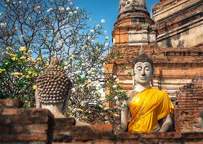
Just about 1 hour north of Bangkok on your map, you'll find the Ayutthaya Historical Park, a UNESCO World Heritage site that was once one of the most powerful cities on Earth.
On our map, you can find the most photographed spot—Wat Mahathat, the three massive, bell-shaped stupas of Wat Phra Si Sanphet, the riverside Wat Chaiwatthanaram, and the 42-meter-long reclining Buddha in Wat Lokkayasutha.
Cultural North (Chiang Mai & Chiang Rai)
| Attractions | Location (GPS) | Highlights |
|---|---|---|
| Chiang Mai Old City | Chiang Mai (18.7897° N, 98.9858° E) | Right in the heart of the city. Include the iconic main entrance - Tha Phae Gate, the Wat Phra Singh, and the ruins of Wat Chedi Luang. |
| Sunday Night Market | Chiang Mai (18.7882° N, 98.9881° E) | Right in the old city. The streets come alive with vendors selling crafts, food, and more. |
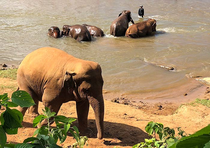
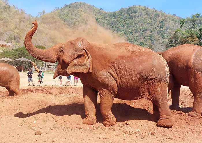
| Elephant Jungle Sanctuary | Chiang Mai (18.6923° N, 98.8690° E) | Southwest of the city. We'll get to meet rescued elephants and learn about them. |
| Doi Suthep | Chiang Mai (18.8050° N, 98.9216° E) | Up in the mountains overlooking Chiang Mai. Climb up to see panoramic city views. |
| White Temple | Chiang Rai (19.8233° N, 99.7627° E) | South of Chiang Rai. This temple is like something out of a dream – all white and sparkly. |
| Golden Triangle Viewpoint | Chiang Rai (20.3529° N, 100.0830° E) | North of Chiang Rai. Where Thailand, Laos, and Myanmar meet. Lots of history here. |
| Hall of Opium | Chiang Rai (20.3646° N, 100.0735° E) | Located in the Golden Triangle area. This museum explores the history of opium, its trade, and its impact. |
| Long Neck Karen Village | Chiang Rai (20.0196° N, 99.8899° E) | Found in northwest of Chiang Rai. Visit villages of the Karen people, known for the distinctive brass rings worn by the women. |
Heading up into the mountains of the North, Chiang Mai is where the old world meets nature.
You'll see the Old City walls on the map, including Tha Phae Gate and the ruins of Wat Chedi Luang. Just outside the city, we can visit the ethical Elephant Jungle Sanctuary or climb up to Wat Phra That Doi Suthep for a view that overlooks the whole valley.
Even further north in Chiang Rai, the map points you to the "dream-like" White Temple and the historic Golden Triangle, where you can stand at the viewpoint and see Thailand, Laos, and Myanmar all at once.
Tropical South (Phuket)
| Attractions | Location (GPS) | Highlights |
|---|---|---|
| Phang Nga Bay | Near Phuket (8.2446° N, 98.5635° E) | Northeast of Phuket. Those tall limestone cliffs rising from the sea? Iconic! We can kayak and explore. |
| Phuket Old Town | Phuket (7.8859° N, 98.3876° E) | In the heart of Phuket. Charming Sino-Portuguese architecture, vibrant streets, and a rich history. |
| Patong Beach | Phuket (7.8962° N, 98.2954° E) | On the west coast. This is where the action is – nightlife, water sports, shopping... |
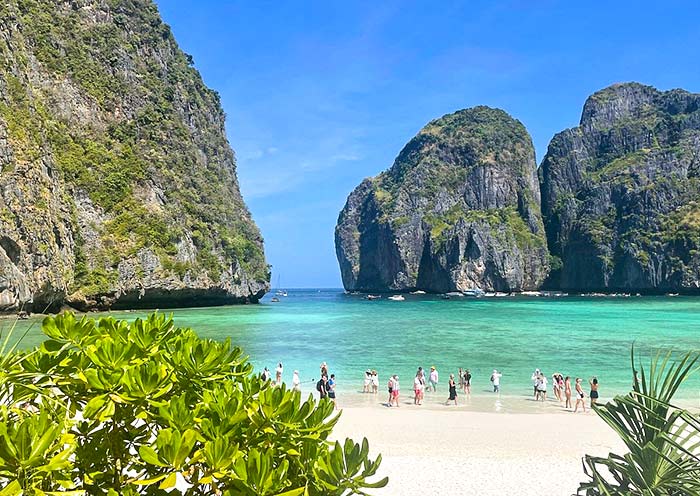
| Phi Phi Islands | Krabi/Phuket (7.7407° N, 98.7784° E) | Southeast of Phuket. Picture-perfect beaches, clear blue water, and lots of snorkeling. Paradise! |
Finally, looking at the South on our map, Phuket is your gateway to paradise.
You can explore the charming Old Town or head to Patong Beach for the nightlife. But don't miss the icons: the limestone cliffs of Phang Nga Bay to the northeast and the picture-perfect Phi Phi Islands just a short boat ride away.
Map of Thailand Islands and Beaches: Best Coastal Routes
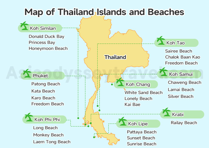
Of course, you can't visit Thailand without a bit of sand between your toes! There's more to expect except the Phuket Island mentioned above!
The best coastal routes are split between the Andaman Sea (West) and the Gulf of Thailand (East). Top island-hopping loops include Phuket-Phi Phi-Krabi in the west and Koh Samui-Koh Phangan-Koh Tao in the east.
Take a peek at our Map of Thailand Islands and Beaches to find your perfect slice of paradise.
The West Coast: Andaman Sea Adventures
Starting on the left side of the map, the Andaman Sea is home to some of the world's most iconic landscapes.
| Islands | Beaches | Best Time to Go |
|---|---|---|
| Phuket | Patong Beach, Kata Beach, Karon Beach, Freedom Beach | Nov to Apr |
| Koh Phi Phi | Long Beach, Monkey Beach, Laem Tong Beach | Nov to Apr |
| Krabi | Railay Beach | Nov to Apr |
| Koh Similan | Donald Duck Bay, Princess Bay, Honeymoon Beach | Nov to Apr |
| Koh Lipe | Pattaya Beach, Sunrise Beach, Sunset Beach | Nov to Apr |
Phuket, our largest island, is the perfect starting point.
You can find the party at Patong Beach, family-friendly vibes at Kata, or plenty of space for long walks at Karon. If you're looking for a hidden gem, we can hop on a boat to reach the secluded Freedom Beach.
Nearby, the famous Koh Phi Phi awaits.
Long Beach is great for views, and it's a bit quieter, Monkey Beach is, well, full of monkeys! And Laem Tong Beach, on the northern tip, is pure peace. You'll need to take a ferry from Phuket or Krabi to get here.
Just across the water is Krabi, where the world-famous Railay Beach is tucked away behind massive limestone cliffs—it's only reachable by boat and feels like a secret world.
For true adventurers, the Koh Similan islands are a diver's dream. It's actually a group of islands, a National Park.
Donald Duck Bay is great for snorkeling and has those famous rock formations. Princess Bay is just stunning, with pristine beaches. And Honeymoon Beach is perfect for romance and tranquility.
If you head all the way south on the map, you'll hit Koh Lipe.
Here, Pattaya Beach is buzzing, with the most shops and restaurants. Sunrise Beach is so calm, ideal for starting your day peacefully. And Sunset Beach is romantic, perfect for evening strolls.
- Best Time: November to April offers the clearest waters and best visibility for diving on the West Coast.
- Transport: Speedboats and ferries are the primary way to move between these Andaman gems.
The East Coast: Gulf of Thailand Escapes
Switching over to the right side of the map, the Gulf of Thailand offers a totally different, laid-back energy.
| Islands | Beaches | Best Time to Go |
|---|---|---|
| Koh Samui | Chaweng Beach, Silver Beach, Lamai Beach | Jan to Aug |
| Koh Tao | Sairee Beach, Chalok Baan Kao, Freedom Beach | Jan to Aug |
| Koh Chang | White Sand Beach, Lonely Beach, Kai Bae | Jan to Aug |
Koh Samui is a top pick for those who want everything at their fingertips, especially around the lively Chaweng Beach. For a quieter escape, I love taking guests to the tiny slice of heaven known as Silver Beach or Lamai.
Just a short ferry ride away, Koh Tao is our "Diver's Paradise"!
Sairee Beach is vibrant, with stunning sunsets and a lively social scene. Chalok Baan Kao is laid-back, with shallower waters, good for families and beginner divers. And Freedom Beach is your escape, a small, peaceful bay.
Finally, closer to the Cambodian border, you'll see Koh Chang on the map.
White Sand Beach is the most developed, with many resorts and amenities. Lonely Beach is for backpackers, offering budget-friendly options and a relaxed atmosphere. And Kai Bae is a good mix of both.
Thailand Travel Map: Recommended Trip Lengths & Itinerary Ideas
Here I've got 2 Thailand Travel Maps for you. One is to help you to plan the travel length, while the other one outlines a 10-day itinerary route.
Suggested Travel Lengths by Destination
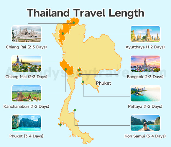
This Thailand Travel Map suggests how long to stay in each place to get the most out of your visit.
For a leisure trip in Thailand, a 10 to 14-day itinerary is recommended. You can cover the "Golden Triangle" of Bangkok (1-3 days), Chiang Mai (2-3 days) and Chiang Rai (2-3 days) in the northern mountains, and one beach destination like Phuket (3-4 days).
Here's the travel lengths breakdown for more Thailand destinations:
| Destinations | Suggested Travel Length |
|---|---|
| Bangkok | 2-3 Days |
| Chiang Mai | 2-3 Days |
| Chiang Rai | 2-3 Days |
| Kanchanaburi | 1-2 Days |
| Ayutthaya | 1-2 Days |
| Phuket | 3-4 Days |
| Pattaya | 1-2 Days |
| Koh Samui | 3-4 Days |
Travel Map of Thailand with a Classic Itinerary
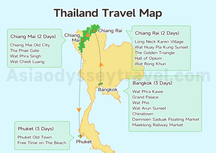
For first-time visitors, I always suggest starting in Bangkok. As you can see on our Thailand Travel Map, the best travel route is to head north first, then follow a North-to-South flow.
During this 10-day itinerary on map, you'll spend 3 days in Bangkok, then 2 days in Chiang Rai, 2 days in Chiang Mai, and finish with 3 days in Phuket.
- Take domestic flights to minimize transit time.
- November to February offers the most stable weather nationwide.
Check out the day-by-day itinerary layout:
| Day | Destinations | Connections | Highlights |
|---|---|---|---|
| 1 | Bangkok Arrival | By Car | / |
| 2 | Bangkok City Tour | By Car | Wat Phra Kawe, Grand Palace, Wat Pho, Wat Arun Sunset, Chinatown |
| 3 | Bangkok Excursions | By Car | Damnoen Saduak Floating Market, Maeklong Railway Market |
| 4 | Bangkok to Chiang Rai | By Flight | Long Neck Karen Village, Wat Huay Pla Kung Sunset (Big Buddha) |
| 5 | Chiang Rai - Golden Triangle - Chiang Mai | By Car | The Golden Triangle, Hall of Opium, Wat Rong Khun (White Temple) |
| 6 | Chiang Mai | By Car | Chiang Mai Old City, Tha Phae Gate, Wat Phra Singh, Wat Chedi Luang |
| 7 | Chiang Mai Excursion | By Car | Elephant Jungle Sanctuary |
| 8 | Chiang Mai to Phuket | By Flight | Half-day Foodie tour to Phuket Old Town (optional) |
| 9 | Phuket Tour/Free Time on The Beach | / | / |
| 10 | Phuket Departure | By Car | / |
10 Days Popular Thailand Tour with Golden Triangle & Phuket Island Hopping
Bangkok - Chiang Rai - Chiang Mai - Phuket
Thailand Transportation & Route Map: How to Get to & around Thailand?
Planning your trip is easy with our 2-step mapping guide.
Below, you'll find an International Thailand Route Map to help you plan your arrival from major Asian hubs, followed by a Domestic Thailand Transportation Map designed to help you navigate between Thailand's cities and islands with ease.
Getting to Thailand
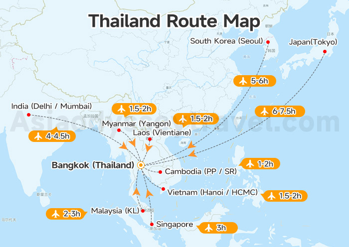
As mentioned earlier, Thailand is a premier regional hub, with direct flight times of 1–3 hours from SE Asia neighbors and 4–7.5 hours from major Asian hubs like India and Japan.
Think of the Thailand Transportation Map as your cheat sheet to Thailand's common flight connections. It shows how long it takes from different spots.
| Departure | Arrival | Duration | Flight Type |
|---|---|---|---|
| South Korea (Seoul) | Bangkok (Thailand) | 5-6h | Direct |
| Japan (Tokyo) | Bangkok (Thailand) | 6-7.5h | Direct |
| India (Delhi / Mumbai) | Bangkok (Thailand) | 4-4.5h | Direct |
| Vietnam (Hanoi / HCMC) | Bangkok (Thailand) | 1.5-2h | Direct |
| Myanmar (Yangon) | Bangkok (Thailand) | 1.5-2h | Direct |
| Laos (Vientiane) | Bangkok (Thailand) | 1.5-2h | Direct |
| Cambodia (PP / SR) | Bangkok (Thailand) | 1-2h | Direct |
| Malaysia (KL) | Bangkok (Thailand) | 2-3h | Direct |
| Singapore | Bangkok (Thailand) | 3h | Direct |
Note: The data shown is for your reference only. Please check the latest information when making your booking/inquiry.
Getting around Thailand
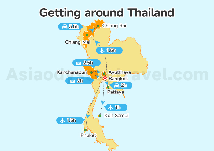
Domestic travel is highly efficient, featuring 90-minute flights from Bangkok to Northern or Southern hubs, and convenient 2–3.5 hour road connections between regional clusters like Bangkok-Pattaya or Chiang Mai-Chiang Rai.
Now it's time for getting around Thailand! This Thailand Route Map helps you plan your travel around Thailand, showing routes and travel times.
| Departure | Arrival | Transport Mode | Time Required |
|---|---|---|---|
| Bangkok | Chiang Mai | Flight | 1.5h |
| Chiang Mai | Chiang Rai | Driving | 3.5h |
| Bangkok | Phuket | Flight | 1.5h |
| Bangkok | Pattaya | Driving | 2h |
| Bangkok | Kanchanaburi | Driving | 2h |
| Kanchanaburi | Ayutthaya | Driving | 2.5h |
| Bangkok | Koh Samui | Flight | 1h |
Note: Information in the table is provided as a guide. Please verify details when you search.
Thailand Map with Cities & Airports: Major Entry Points & Travel Hubs
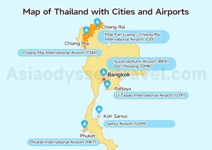
Our primary international gateways are Suvarnabhumi (BKK) and Don Mueang (DMK) in Bangkok, supported by regional international airports in Phuket (HKT), Chiang Mai (CNX), and Koh Samui (USM).
Most airports are located within 15–45 minutes of their respective city centers, ensuring seamless transitions from air to hotel.
This Map of Thailand with Cities and Airports is your go-to guide for navigating our beautiful country! It shows you where the big cities and airports are located.
- Bangkok: Our main gateway! Suvarnabhumi Airport (BKK) is east of the city, about a 30-45 minute drive, depending on traffic. Don Mueang (DMK) is north, closer, around 20-30 minutes.
- Phuket: Phuket International Airport (HKT) is in the north, a 45-minute to 1-hour drive to popular beaches like Patong.
- Chiang Mai: Chiang Mai International Airport (CNX) is very close to the city center, just a 15-20 minute ride.
- Chiang Rai: Mae Fah Luang - Chiang Rai International Airport (CEI) is located northeast of the city, and the drive to the city center is generally around 15-20 minutes.
- Pattaya: U-Tapao International Airport (UTP) is southeast, about a 45-minute drive. Most travelers fly to BKK in Bangkok, which is about 2 hours away from Pattaya.
- Koh Samui: Samui Airport (USM) is conveniently located near Chaweng, the main beach area, making transfers quick, usually 10-15 minutes.
Bangkok is our main heartbeat, and you'll likely land at Suvarnabhumi (BKK). Give yourself about 45 minutes to get into the city from there.
However, if you're flying a budget carrier, you might land at Don Mueang (DMK), which is a bit closer to the city center.
Let Us—Asia Odyssey Travel, Show You Thailand on Map!
Explore Thailand on Map with Asia Odyssey Travel for an amazing journey!
- Tailored Experiences, Just for You: Your dream trip, your way. We don't do cookie-cutter tours.
- Stress-Free Travel, 24/7 Support: Relax and enjoy every moment. We take care of all the details, big and small.
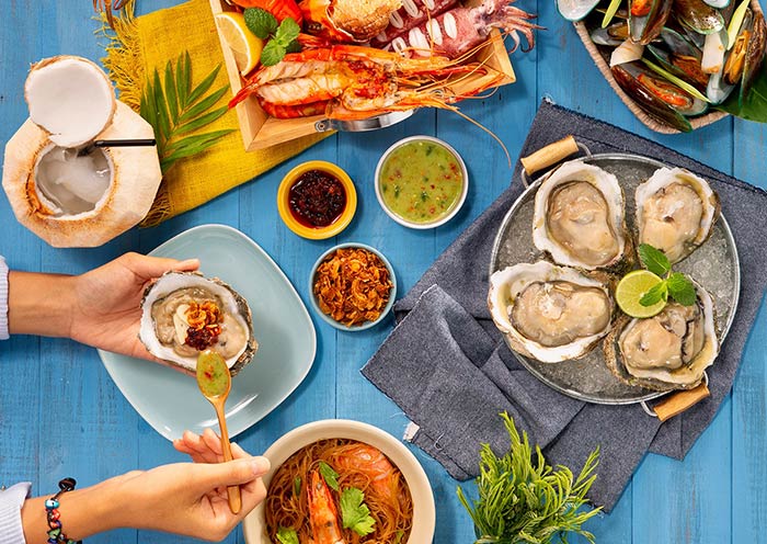
- Authentic Encounters, Cultural Immersion: We'll introduce you to the real Thailand – its vibrant culture, delicious food, and warm-hearted people.
Let us handle the details, so you can immerse yourself in the beauty and culture of Thailand, creating memories that will last a lifetime!
To experience the best of Thailand, check out more maps of Thailand, from the vibrant cityscapes of Bangkok Map to the stunning beaches of Phuket Map, the cultural heartland of Chiang Mai, the lively shores of Pattaya Map, and the unique charm of Chiang Rai Map.