+852 5394 6901
 Take China Group Tours in 2026/2027 to enjoy 30% discount compared to private tour. Same Experience & Lowest Price!

Location Map of Changsha: Where is Changsha on the Map of China?
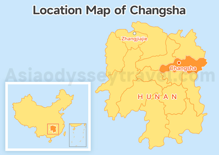
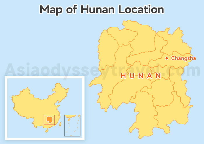
First, where is Changsha city? You'll find this vibrant capital sitting in the south-central part of China at 28.23° N latitude and 112.93° E longitude.
It is the heart of Hunan Province, perched right along the lower reaches of the Xiang River.
When you look at Changsha on map, you'll see it sits at a perfect crossroads.
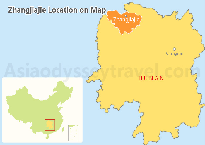
It's about 350 kilometers (217 miles) southeast of the Zhangjiajie National Forest Park. Thanks to the high-speed rail, you can zip from the city skyscrapers to those misty mountain peaks in just over 2 hours!
8 Hunan Maps: Location, Cities, Attractions & Routes | 2026
Changsha Attractions Map: What to See in Changsha City?
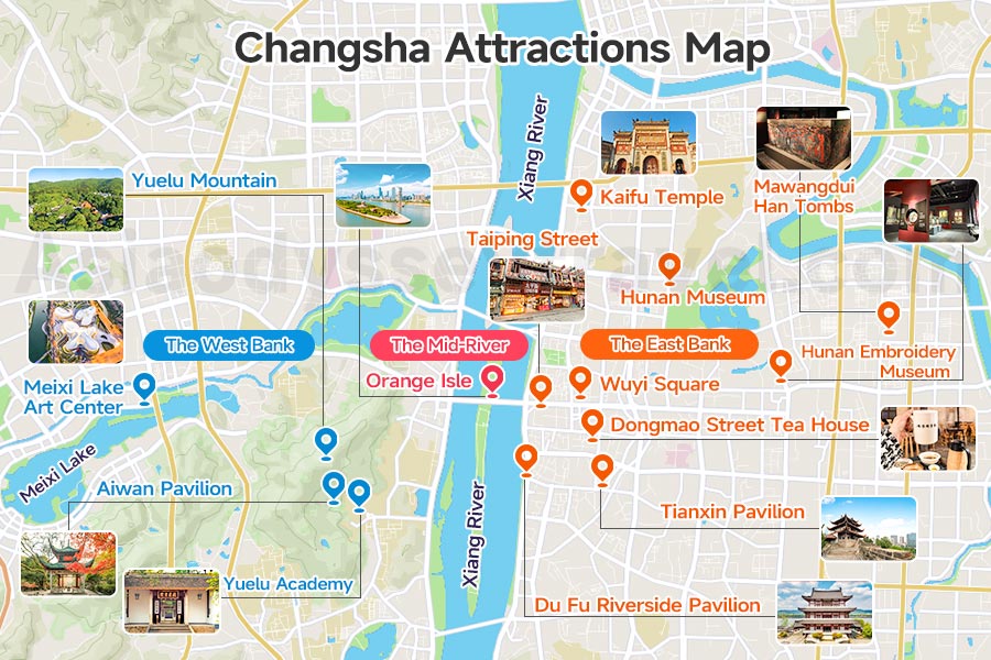
So, what to see in Changsha? I've grouped the best spots by geography on this Changsha Attractions Map.
The city is a tale of two banks. The Xiang River is the heartbeat of Changsha, and it also acts as a natural divider.
To keep your trip relaxing, I recommend picking one "side" per half-day so you aren't constantly crossing bridges in traffic.
| Attraction | Bank | Lat/Long | Entry Fee | Opening Hours |
| Hunan Museum (湖南博物院) | East | 28.21, 112.99 | Free (Book 7 days ahead) | 09:00 - 17:00 (Closed Mon) |
| Kaifu Temple (开福寺) | East | 28.21, 112.98 | 10 RMB | 06:30 - 17:30 |
| Wuyi Square (五一广场) | East | 28.19, 112.97 | Free | 24 Hours |
| Taiping Old Street (太平老街) | East | 28.19, 112.97 | Free | 24 Hours |
| Dongmao Street Tea House (东茅街茶馆) | East | 28.19, 112.98 | Tea varies | 09:00 - 22:00 |
| Tianxin Pavilion (天心阁) | East | 28.18, 112.98 | 28 RMB (Park is Free) | 08:00 - 17:00 |
| Du Fu Riverside Pavilion (杜甫江阁) | East | 28.18, 112.97 | 18 RMB | 09:00 - 22:00 |
| Hunan Embroidery Museum (湘绣博物馆) | East | 28.20, 113.00 | Free | 09:00 - 17:00 (Closed Mon) |
| Mawangdui Han Tombs (马王堆汉墓) | East | 28.21, 113.02 | 2 RMB | 09:00 - 17:00 (Closed Mon) |
| Orange Isle (橘子洲) | Mid-River | 28.18, 112.96 | Free (Train: 40 RMB) | 07:00 - 22:00 |
| Yuelu Academy (岳麓书院) | West | 28.18, 112.94 | 40 RMB | 08:00 - 17:00 |
| Yuelu Mountain (岳麓山) | West | 28.18, 112.93 | Free | 06:00 - 22:00 |
| Aiwan Pavilion (爱晚亭) | West | 28.18, 112.94 | Free | 06:00 - 22:00 |
| Meixi Lake Art Center (梅溪湖) | West | 28.19, 112.89 | Free (Shows vary) | 24 Hours (Park) |
The East Bank
This is the soul of the city's hustle and bustle.
Start at the Hunan Museum to see Lady Dai (辛追), a 2,000-year-old mummy that still has soft skin. Afterward, wander through Wuyi Square and Taiping Street to see beautiful old architecture mixed with trendy shops.
If you want a quiet moment, the Dongmao Street Tea House feels like stepping back 40 years.
For history buffs, Tianxin Pavilion, Kaifu Temple and the Hunan Embroidery Museum are local treasures.
Right across the river from Orange Isle and Mount Yuelu sits the stunning Du Fu River Pavilion. It's the perfect spot to watch the sunset over the water!
The Mid-River
Orange Isle (Juzizhou Island) sits right in the middle of the Xiang River.
It's a long, narrow park. You have to take the little tram to the tip of the island to see the giant, beautiful statue of a young Chairman Mao. It is the most famous landmark in the city!
The West Bank
This is where the city slows down.
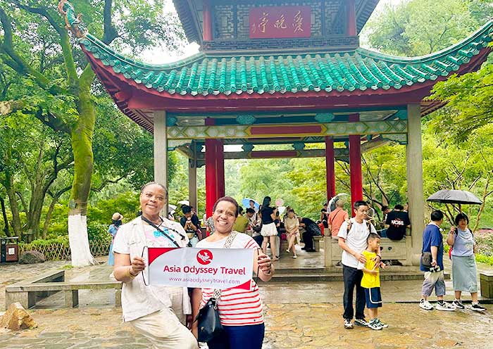
Yuelu Mountain is perfect for a morning hike. Nestled at its base is Yuelu Academy, one of the oldest universities in the world. Don't miss the red-roofed Aiwan Pavilion, especially beautiful in the fall.
If you love modern design, head further west to Meixi Lake to see the futuristic culture center designed by Zaha Hadid.
Spend your mornings on the Mid-River and West Bank for the fresh mountain air and history, then head to the East Bank in the evening when the neon lights and food stalls at Wuyi Square really come to life.
Map of Changsha Food Street: Where to Find Authentic Changsha Street Food?
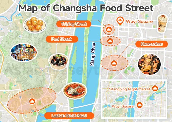
You can't talk about a Changsha City Map without mentioning the food! This is a city that lives to eat.
To find the real-deal flavors, you have to go where the locals go. I've put together this Changsha food street guide so you don't miss out on the spicy goodness.
| Food Zone | Bank | Opening Hours | Lat/Long |
| Wuyi Square (五一广场) | East | 10:00 - Late Night | 28.19°N / 112.97°E |
| Taiping Street (太平街) | East | 09:00 - 23:00 | 28.19°N / 112.97°E |
| Pozi Street (坡子街) | East | 10:00 - Midnight | 28.19°N / 112.97°E |
| Nanmenkou (南门口) | East | 18:00 - 02:00 | 28.18°N / 112.97°E |
| Sifangping Night Market (四方坪夜市) | East | 18:00 - 01:00 (Peak) | 28.23°N / 112.99°E |
| Lushan South Road (麓山南路) | West | 11:00 - 22:00 | 28.17°N / 112.94°E |
Taiping & Pozi Street are right next to each other. Pick Taiping for the cool old architecture and Pozi for the Fire Palace (Huo Gong Dian).
Try Lushan South Road near the University Town for cheap, student-friendly bites.
If you want to skip the "tourist traps" and eat where the locals live, go for Nanmenkou.
You can't miss the crispy, blackened Stinky Tofu (Chòu Dòu Fu) and sweet, chewy Sugar Oil Baba (Táng Yóu Bā Bā).
For a real local night out, grab a big bowl of Spicy Crayfish (Kǒu Wèi Xiā) and some smoky grilled skewers!
When ordering, remember that "Mildly Spicy" (Wēi Là) in Changsha is usually a "Level 10" anywhere else. Have a bottle of milk ready!
2 Travel Maps of Changsha: How Many Days in Changsha?
How many days do you need? I think 1 to 2 days is plenty to see the city highlights before moving on to the mountains.
We've designed two Travel Maps of Changsha to help you choose your pace.
#1 Travel Map of Changsha: A 1-Day Changsha Highlights Route
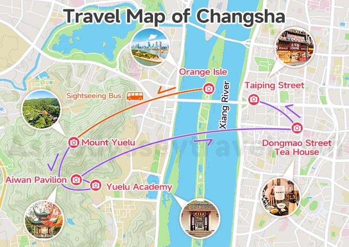
This is the perfect "greatest hits" day. We follow the “Middle - West - East” route: Orange Isle → Mount Yuelu (Take the Sightseeing Bus) → Yuelu Academy → Aiwan Pavilion → Dongmao Street Tea House → Taiping Street.
| When | What to Do |
| Morning | Start at Orange Isle to beat the crowds. |
| Mid-day | Head to Mount Yuelu, take the sightseeing bus up, visit Yuelu Academy, and relax at Aiwan Pavilion. |
| Afternoon | Cross back east to Dongmao Street Tea House for a break. |
| Evening | Finish strong at Taiping Street for shopping and snacks. |
If you have more time, definitely add the Hunan Museum to your morning!
#2 Travel Map of Changsha: 8 Days in Changsha, Zhangjiajie, Furong & Fenghuang
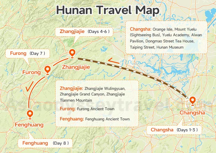
I highly recommend going beyond the Changsha city limits to see the real magic of Hunan.
This 8-day loop is my favorite way to show travelers the contrast between our high-energy city and misty landscapes of the countryside.
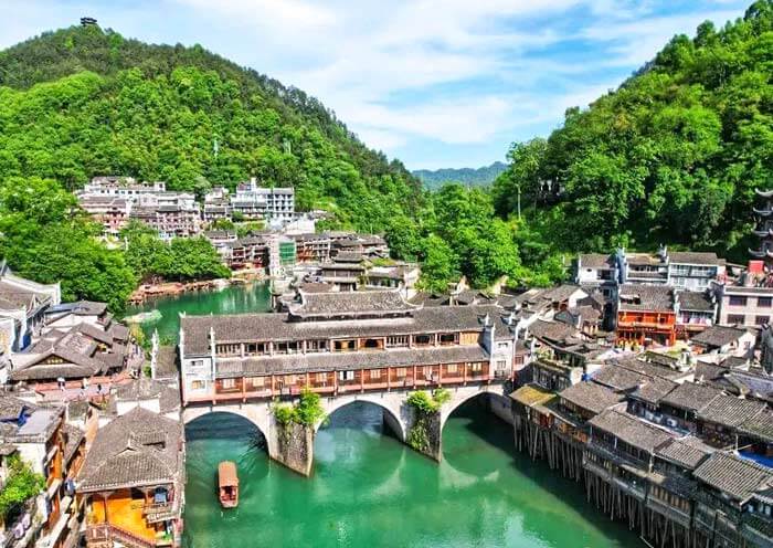
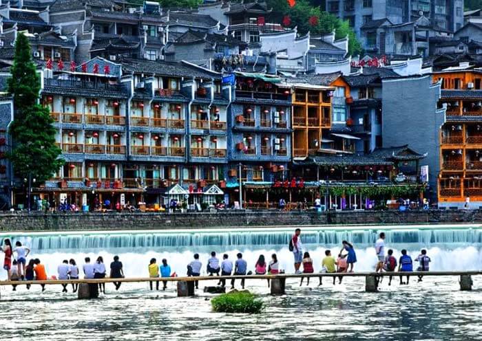
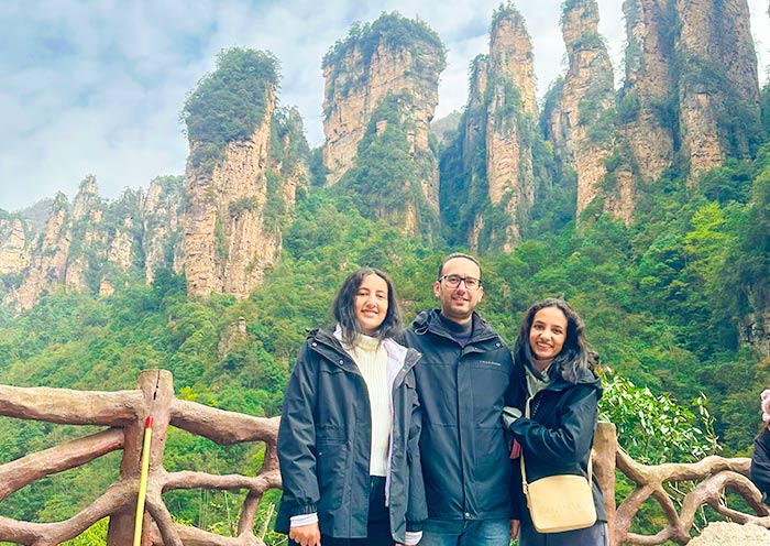
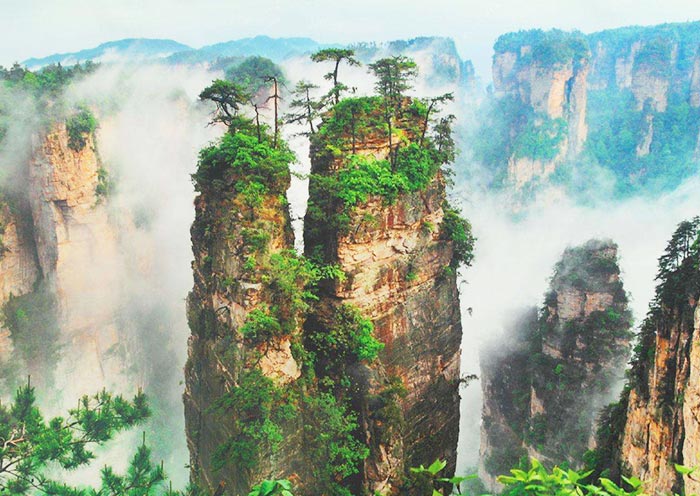
You'll start with the neon lights and spicy snacks of Changsha, then zip over to the towering "Avatar" peaks of Zhangjiajie, before winding down in the riverside stilt houses of Furong and Fenghuang.
It is a perfect 8-day journey that hits all the heavy hitters on the map of Changsha Hunan province China.
| Day | Where to Go | What to Do |
| 1 | Arrive in Changsha | Airport or Train Station Transfers, Hotel Check-in |
| 2 | Changsha | Orange Isle, Mount Yuelu (Sightseeing Bus), Yuelu Academy, Aiwan Pavilion, Dongmao Street Tea House, Taiping Street |
| 3 | Changsha to Zhangjiajie | Hunan Museum (Closed on Mondays), Transfer to Zhangjiajie by High Speed Train (2 Hrs) |
| 4 | Zhangjiajie Wulingyuan | From Zhangjiajie National Forest Park to Tianzi Mountain Nature Reserve; Bailong Elevator, Hallelujah Mountains, Tianzi Mountain |
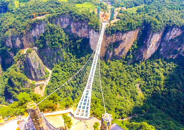
| 5 | Zhangjiajie Grand Canyon | Zhangjiajie Grand Canyon Glass Bridge, Baofeng Lake |
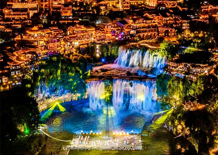
| 6 | Zhangjiajie Tianmen Mountain | Tianmenshan National Forest Park, Cable Car, Tianmen Cave, Glass Walkway, Transfer to Furong Ancient Town (Night View) |
| 7 | Furong to Fenghuang Tour | Furong Ancient Town (Day View), Fenghuang Ancient Town (Tuo River Boating) |
| 8 | Fenghuang Departure | Hotel Check-out, Airport or Train Station Transfer |
8 Days Hunan Highlight Tour: Vivid Changsha, Zhangjiajie, Furong & Fenghuang Town
Changsha - Zhangjiajie - Furong Ancient Town - Fenghuang Ancient Town
 8 Days
 4 Places
Map of Changsha Transportation: How to Get to the City?
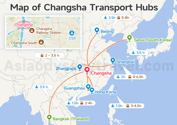
Getting to Changsha is a easy! Since we sit right at the "crossroads" of China's massive high-speed rail network, you can reach us from almost anywhere.
Most travelers arrive at our 2 biggest gates.
Changsha Huanghua International Airport (CSX: 长沙黄花国际机场) is about 25km east of the city center, while Changsha South Railway Station (长沙南站) is located on the southeastern edge of town.
If you're coming from nearby cities in Hunan, you might also pull into the classic Changsha Railway Station (长沙站) right in the middle of the Changsha City Map.
Here is a quick look at how you'll likely reach us:
| From | To | Transport Mode | Duration |
| Beijing | Changsha South / Changsha CSX | Train / Flight | 5-8h / 2.5h |
| Shanghai | Changsha South / Changsha CSX | Train / Flight | 4-6.5h / 2h |
| Guangzhou | Changsha South / Changsha CSX | Train / Flight | 2-4h / 1.5h |
| Hong Kong | Changsha South / Changsha CSX | Train / Flight | 3-4.5h / 1.5h |
| Zhangjiajie | Changsha South / Changsha | Train | 2 – 3.5 h |
| Seoul (South Korea) | Changsha CSX | Flight | 3.5 h |
| Bangkok (Thailand) | Changsha CSX | Flight | 3.5 h |
Changsha Metro Map: The Best Way to Navigate the City
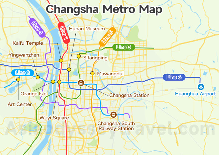
Once you've arrived at one of these big hubs, the best way to skip the city traffic and reach your hotel is by hopping onto the Changsha Subway Map network.
The subway is by far the most convenient way for getting around the city, and it's so easy to use that you'll feel like a local in no time.
Right now, we have 6 main metro lines in operation, forming a massive web that links the airport, the train stations, and almost every spot on your Changsha Attractions Map.
Most of the action happens along Line 2, which is basically our tourist express since it runs right through the heart of the city.
| Attraction | Metro Line | Station Name |
| Wuyi Square & Pozi Street | Line 1 & Line 2 | Wuyi Square (五一广场站) |
| Nanmenkou & Tianxin Pavilion | Line 1 | Nanmenkou (南门口站) |
| Kaifu Temple | Line 1 | Kaifu Temple (开福寺站) |
| Meixi Lake Art Center | Line 2 | Art Center (文化艺术中心) |
| Orange Isle (Mao Statue) | Line 2 | Juzizhou (橘子洲站) |
| Yuelu Mountain & Academy | Line 2 & Line 4 | Yingwanzhen (溁湾镇站) & Hunan University (湖南大学站) |
| Du Fu Riverside Pavilion | Line 2 | Xiangjiang Middle Road (湘江中路站) |
| Changsha South Railway Station | Line 2 & Line 4 | South Railway Station (长沙火车南站) |
| Changsha Station | Line 2 | Railway Station (长沙火车站) |
| Sifangping Night Market | Line 3 | Sifangping (四方坪站) |
| Mawangdui Han Tombs | Line 5 | Mawangdui (马王堆站) |
| Hunan Museum | Line 6 | Martyrs' Park South (烈士公园南站) |
| Huanghua Airport | Line 6 | Huanghua Airport T1 & T2 (黄花机场站) |
The easiest way to pay for the metro tickets is to use the "Transport" or "Travel" code inside your Alipay or WeChat Pay app. Just scan the QR code at the turnstile when you enter and exit.
Changsha to Zhangjiajie Map: How to Connect the Two?
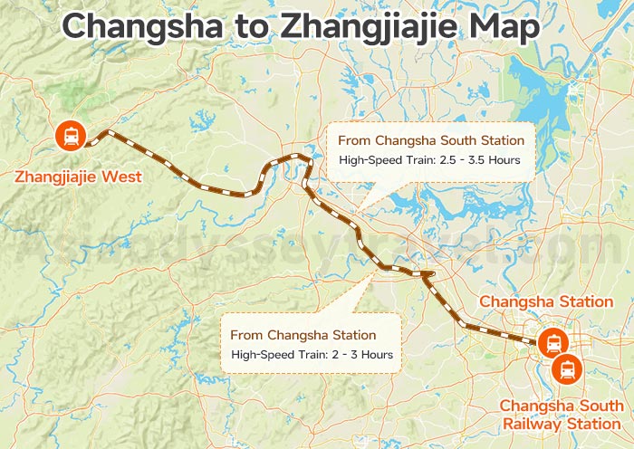
Connecting Changsha and Zhangjiajie is the highlight of any Hunan trip! The Changsha China Map shows a straight shot west to the mountains.
| From | To | Mode | Duration |
| Changsha South | Zhangjiajie West | High-Speed Train | 2 - 3 Hours |
| Changsha | Zhangjiajie West | High-Speed Train | 2.5 - 3.5 Hours |
The high-speed train from Changsha to Zhangjiajie is the most convenient option, and it's what we chose for our trip to Hunan.
Explore Changsha on Map with Your Local Pal, Asia Odyssey Travel
Planning a trip can be a lot, but you don't have to do it alone.
At Asia Odyssey Travel, we're more than just a booking site—we're your local pals on the ground. Whether you want to dive deep into the city with our Changsha Tours or head into the wilderness with our Zhangjiajie Tours, we've got you covered.
Visit us at our Zhangjiajie Office: Office 1117A, Zhongshang Plaza, Yongding District (right near Tianmen Mountain!). We can't wait to show you the real Hunan!








 Data in submission...