Nanjing Location Map: Where Is Nanjing Located on the Map of China?
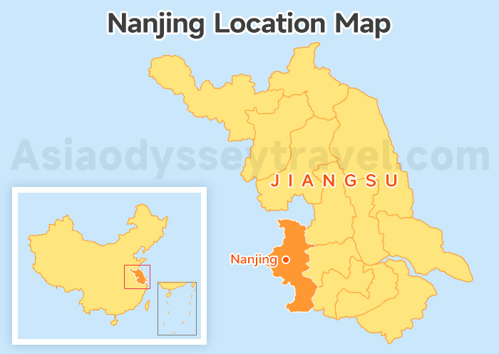
How do you quickly find Nanjing on a map? It's simple - the coordinates 32.069°N, 118.780°E will take you right there. But this Nanjing location map tells you more than just a pin on a map.
Nanjing is the capital of Jiangsu Province in eastern China, sitting on the banks of the Yangtze River. Shanghai and Hangzhou are both nearby.
As a major city on the lower Yangtze, Nanjing has long been an important cultural and political center. For first-time visitors, the most useful thing this location map makes clear is that Nanjing is part of the wealthy East China travel corridor, where fast trains connect major cities in just hours.
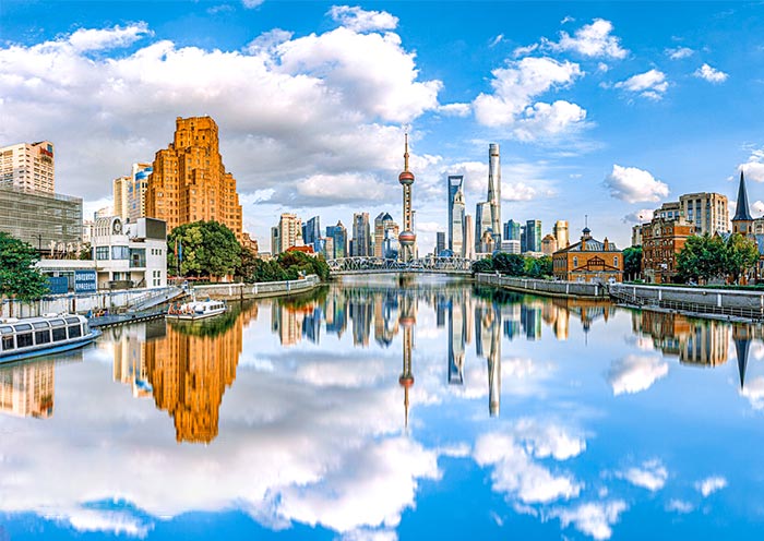
In short, it is much closer to Shanghai than many international travelers expect. This makes Nanjing an ideal addition to a Shanghai trip for anyone who wants to experience deep history, old-city atmosphere, and some of China's most famous historical landmarks.
9 Jiangsu Maps: Location, City, Tourist Spots & Routes | 2026
Shanghai to Nanjing Map - 1h15min by High-Speed Rail, Day Trip or Overnight?
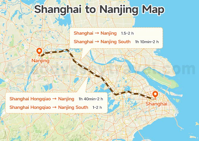
This Shanghai to Nanjing map shows the travel distance, high-speed rail routes, and driving time between the two cities. The focus is on the high-speed rail connection, with departure stations in Shanghai and arrival stations in Nanjing clearly marked on the map.
The distance from Shanghai to Nanjing is about 307 km (191 miles). Driving takes roughly 3.5 hours, but the best way to travel is by high-speed rail.
Shanghai Station and Shanghai Hongqiao Station are the most convenient departure points. On the Nanjing side, Nanjing Station is closest to the city center, while Nanjing South Station is a good alternative.
| Route | Fastest Time | Duration Range | Daily Trains |
|---|---|---|---|
| Shanghai → Nanjing | 1h 30min | 1.5-2 hours | ~35 |
| Shanghai → Nanjing South | 1h 10min | 1h 10min-2 hours | ~51 |
| Shanghai Hongqiao → Nanjing | 1h 40min | 1h 40min-2 hours | ~11 |
| Shanghai Hongqiao → Nanjing South | 1h | 1-2 hours | ~170 |
A day trip works if you plan to focus on just one or two areas. But if you prefer a slower pace, want to catch the sunset, and enjoy an evening along the Qinhuai River, staying overnight is the better choice.
Shanghai to Nanjing High Speed Train: Best Way from Shanghai to Nanjing
Nanjing City Map: Where the Center, Stations and Airport Are
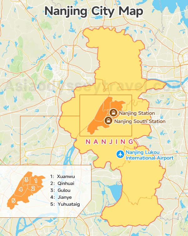
Now it's time to get to know the city itself through our Nanjing City Map. The map shows the full extent of Nanjing, which covers 6,587 square kilometers, and pinpoints the absolute city center - Xinjiekou Square.
It also outlines the 5 central districts of Nanjing: Xuanwu, Qinhuai, Gulou, Jianye, and Yuhuatai. These districts were shaped by the boundaries of the Ming Dynasty imperial city wall, built over 600 years ago.
You can also find the locations of Nanjing's main transport hubs on this map, including Nanjing Station, Nanjing South Station, and the airport.
Nanjing Station is the closest to the city center, about 7 km to the north - roughly 20 minutes by metro. Its address is No. 111 Longpan Road, Xuanwu District, Nanjing.
Nanjing South Station is 9 km from the center, about 30 minutes by metro. Its address is No. 98 Yulan Road, Yuhuatai District, Nanjing.
Nanjing Lukou International Airport is 41 km from the center, about 70 minutes by metro. Its address is Konggangnan Road, Lukou County, Jiangning District, Nanjing.
Nanjing Tourist Attractions Map - 3 Must-See Zones with Detailed Walking Maps
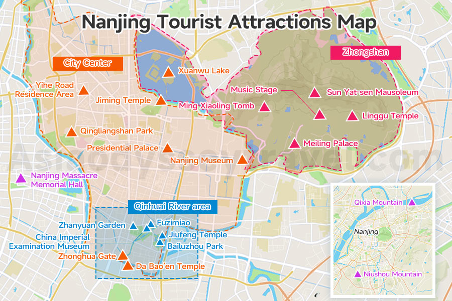
A clear Nanjing tourist attractions map helps first-time visitors see the city in a simple way. It is better to read the map in three main sightseeing zones: City Center, Zhongshan (Purple Mountain), and the Qinhuai River area.
Outside these three zones, the map also marks three other important sights - the Nanjing Massacre Memorial Hall, Niushou Mountain and Qixia Mountain - which we'll cover in the Pro Tips at the end.
City Center Map - Presidential Palace, Jiming Temple, Xuanwu Lake & the Best Ming Wall Walks
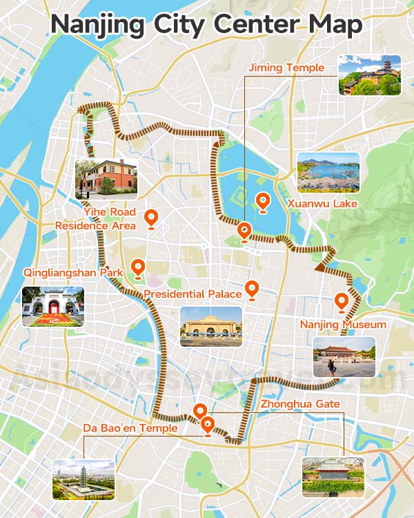
The City Center map outlines the full loop of the Ming Dynasty city wall. Most of Nanjing's downtown sights sit inside it, with Xinjiekou Square - where Metro Lines 1 and 2 cross - right at the center.
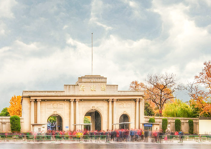
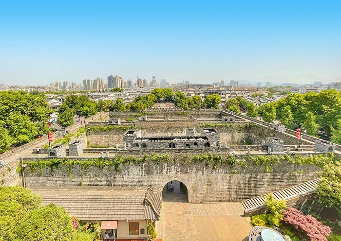
The top sights in this zone are Presidential Palace, Jiming Temple, Xuanwu Lake, and Zhonghua Gate. These are the places most visitors should not miss.
The Presidential Palace is one of Nanjing's key historic landmarks. Jiming Temple is one of the city's best-known temples, especially popular in spring. Xuanwu Lake is ideal for scenic walks, while Zhonghua Gate is one of the best places to understand the scale of Nanjing's old city wall.
Don't miss the Ming Wall walk between Jiming Temple and Xuanwu Lake - it's the single best walk in Nanjing.
Other notable stops on this map include Nanjing Museum, Qingliangshan Park, Da Bao'en Temple. And Yihe Road Republican-era area, a tree-lined street of 1930s Republic-era villas that's become one of Nanjing's most photographed spots.
Zhongshan (Purple Mountain) Map - Sun Yat-sen Mausoleum, Ming Xiaoling Tomb & Linggu Temple
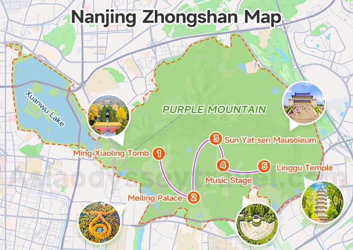
The Zhongshan map covers Nanjing's most famous scenic and historic area. This is not a compact walking zone, so the map is important because it shows the key sights and the classic sightseeing route.
The best route is usually: Ming Xiaoling Tomb → Meiling Palace → Sun Yat-sen Mausoleum → Music Stage → Linggu Temple or Observatory.
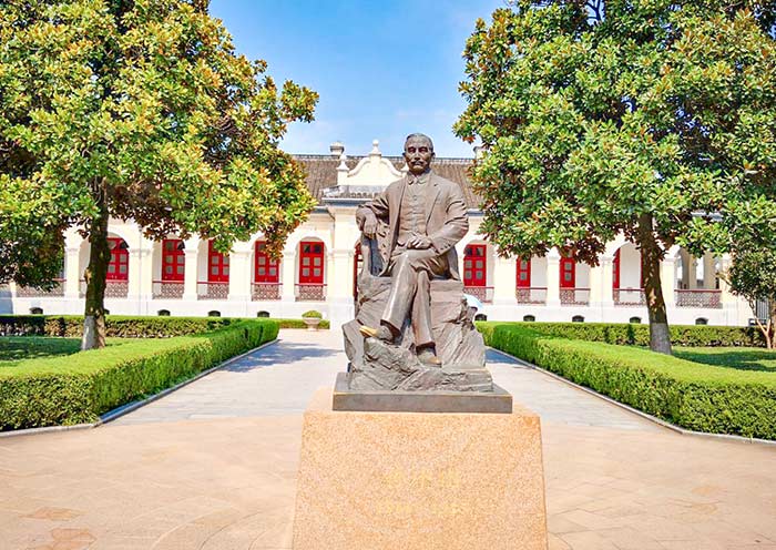
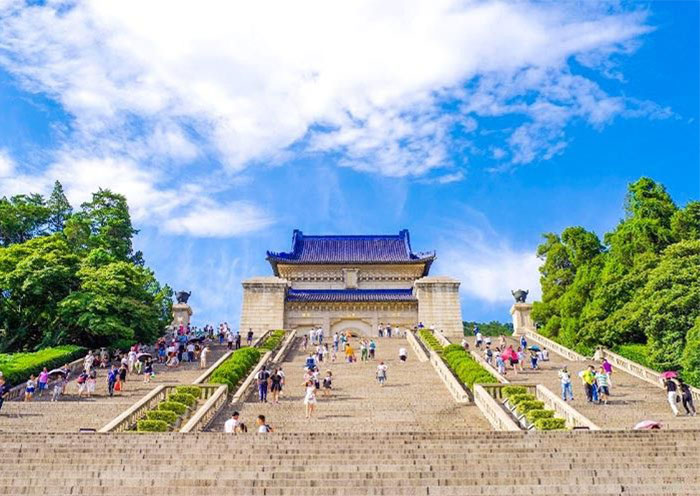
Among these, the three biggest highlights are Sun Yat-sen Mausoleum, Ming Xiaoling Tomb, and Linggu Temple. These are the must-see points on the map. Sun Yat-sen Mausoleum is Nanjing's most iconic landmark.
Ming Xiaoling Tomb is the city's most important imperial site. Linggu Temple offers a quieter and more spiritual stop. Meiling Palace and the Music Stage are good additions if you have more time.
If you only have half a day, use the map to focus on two or three major sights instead of trying to see everything.
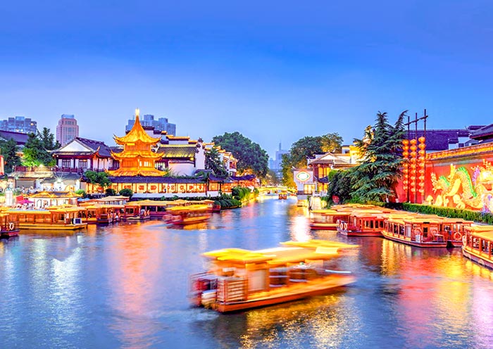
Qinhuai River Map: Confucius Temple, Laomendong & Night Views
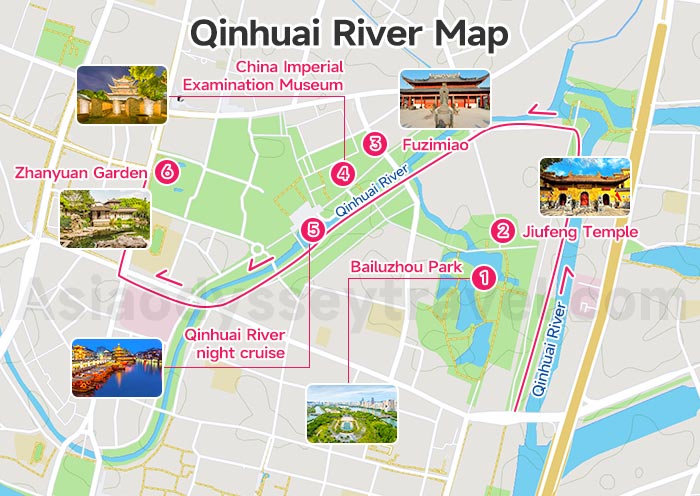
The Qinhuai River map traces an evening walking route from Wudingmen to Sanshanjie - about 4 km along the river.
The route passes Bailuzhou Park and Jiufeng Temple before entering the lively Fuzimiao (Confucius Temple) district - Nanjing's busiest night scene. Right beside the temple, the China Imperial Examination Museum is a well-designed underground exhibit and well worth an hour.
From Wende Bridge, the Qinhuai River night cruise (80-100 RMB, 50 minutes) takes you past lantern-lit buildings reflected on the water - the most popular evening activity in the city.
Continue west to Zhanyuan Garden, a beautiful Ming-era classical garden, then through Xinanli historic lane to Sanshanjie metro station.
If you have extra time, do not miss Niushoushan, the Memorial Hall of the Victims in Nanjing Massacre, and Qixia Mountain. They are outside the three main tourist zones, but they are still important points on a complete Nanjing tourist map.
Nanjing Cherry Blossom Map - Best Spots & Routes in March and Early April
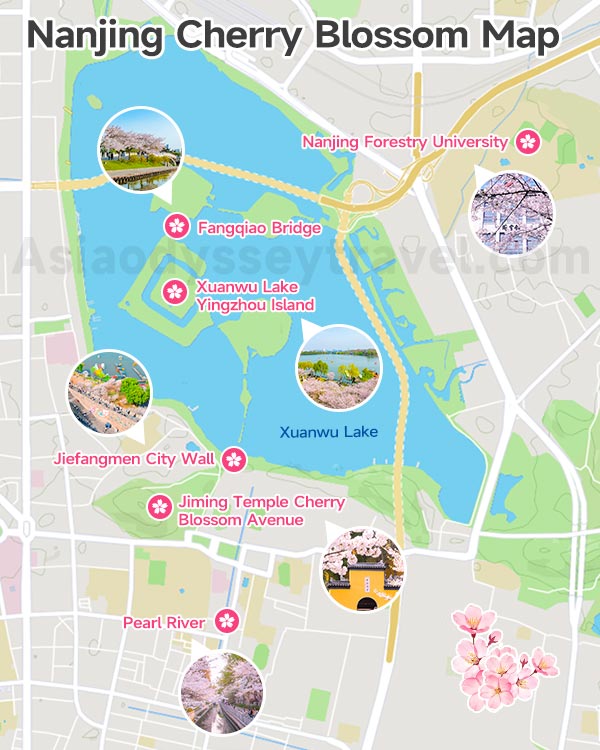
Nanjing is one of the best cities in China for cherry blossoms, with peak bloom usually falling between mid-March and early April. The cherry blossom map below marks 6 top spots across the city.
Jiming Temple Cherry Blossom Avenue is the most famous - only 200 meters long but so stunning.
Jiefangmen city wall for a god's-eye view of spring colors around Xuanwu Lake.
Xuanwu Lake Yingzhou Island for cherry blossom tunnels and picnic-friendly lawns.
Fangqiao Bridge where cherry trees frame Zifeng Tower in the background.
For evening visits, Pearl River is a local favorite for night-lit cherry blossoms.
And if you want a youthful, campus vibe, Nanjing Forestry University has a 1.5 km cherry blossom corridor stretching from the library to the classroom buildings - one of the most photogenic walks in the city.
On the map, you can connect three of these spots in one day: Nanjing Station - Nanjing Forestry University - Xuanwu Lake - Jiefangmen city wall - Jiming Temple - Pearl River.
Nanjing Subway Map 2026 (Metro) - The 3 Lines That Connect Every Major Sight
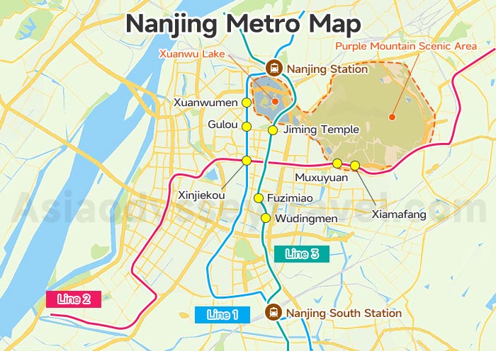
Nanjing's metro network now has over 12 lines, but as a visitor you only need to know three. Lines 1, 2 and 3 will carry you to every major sight, hotel zone and transport hub covered in this guide.
The Nanjing metro map below highlights just these three lines with all the tourist-relevant stops marked.
Metro Line S1 also connects Lukou Airport to Nanjing South Station, so it's likely the first line you'll ride. Once you're in the city, use Alipay's transport QR code to scan in and out at every station - no paper ticket needed.
| Line | Key Tourist Stops | Where It Takes You |
|---|---|---|
| Line 1 | Xinjiekou · Xuanwumen · Gulou · Nanjing Station | City center, Xuanwu Lake, Nanjing Railway Station |
| Line 2 | Xinjiekou · Muxuyuan · Xiamafang | Purple Mountain scenic area, Presidential Palace area |
| Line 3 | Fuzimiao · Wudingmen · Jiming Temple · Nanjing South Station | Confucius Temple, Laomendong, high-speed rail hub |
Where to Stay in Nanjing - Xinjiekou, Fuzimiao or Xuanwu Lake Area?
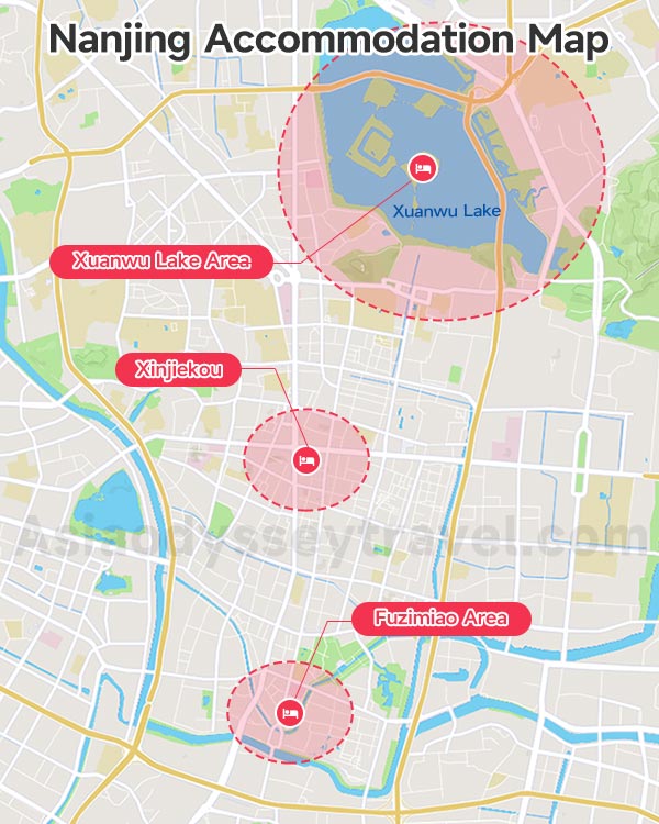
| Area | Best For | Map Advantage |
|---|---|---|
| Xinjiekou | Convenience, shopping, transport | Central position between key zones |
| Fuzimiao | Night views, old streets, lively atmosphere | Best base for evening walks |
| Xuanwu Lake Area | Scenery, quieter setting, easy walks | Good for lake views and north-central sights |
If you want the most practical base on the Nanjing accommodation map, choose Xinjiekou. If you care most about atmosphere, choose Fuzimiao. If you prefer a calmer stay with scenic walks, the Xuanwu Lake area is a very good option.
Nanjing in 2, 3 or 4 Days - Ready-to-Use Maps for First-Time Visitors
Nanjing is perfect for 1-3 days of sightseeing, with clear routes and world-class highlights. If you only have 1 day, we recommend visiting the best of Zhongshan Scenic Area and the Confucius Temple-Qinhuai River area with the help of our attractions map.
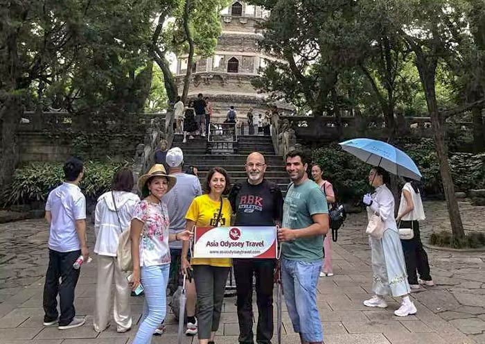
Below are Asia Odyssey Travel's best-selling 2-4 day itinerary maps, carefully designed based on real travel experience and guest feedback.
These tried-and-tested routes help you see the top sights efficiently and travel with ease. You can follow our popular itineraries directly, or contact us for a tailor-made Nanjing tour based on your interests, schedule, and pace.
2 Day Nanjing Itinerary Map
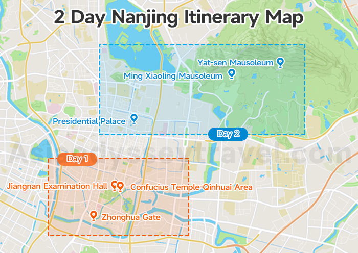
Day 1: Arrival, Zhonghua Gate & City Wall, Confucius Temple-Qinhuai Area, Jiangnan Examination Hall
Day 2: Sun Yat-sen Mausoleum, Ming Xiaoling Mausoleum, Presidential Palace, departure
3 Day Nanjing Itinerary Map
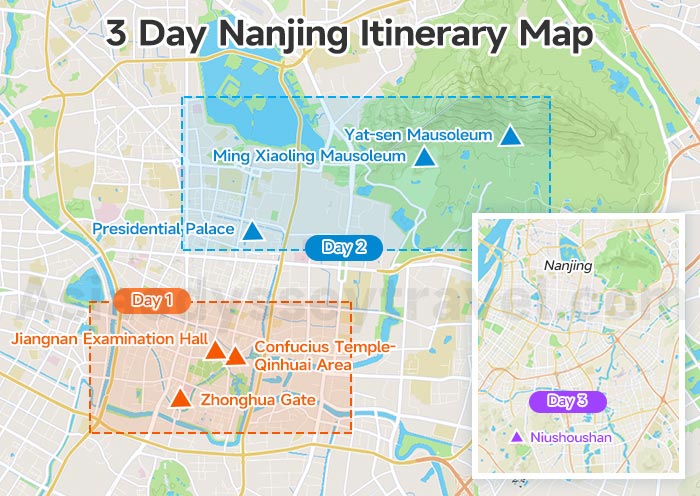
Day 1: Arrival, Zhonghua Gate & City Wall, Confucius Temple-Qinhuai Area, Jiangnan Examination Hall
Day 2: Sun Yat-sen Mausoleum, Ming Xiaoling Mausoleum, Meiling Palace, Presidential Palace
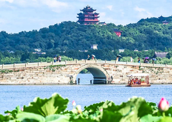
Day 3: Niushoushan, departure
4 Day Shanghai-Nanjing Itinerary Map
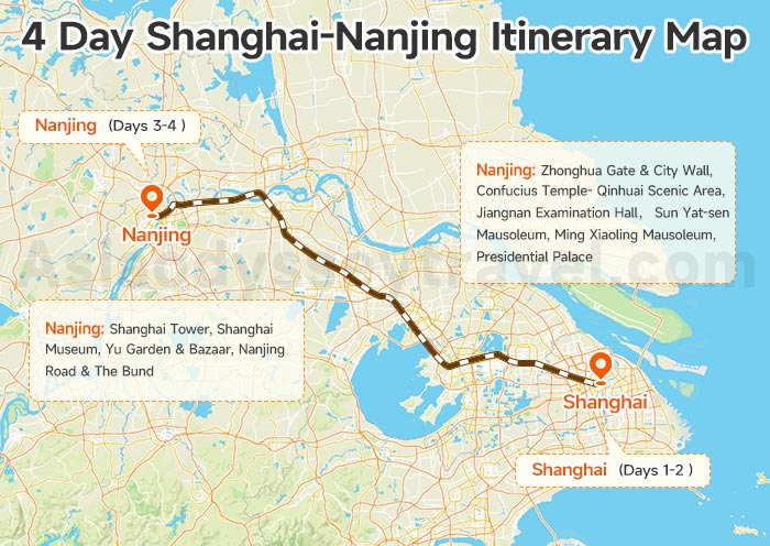
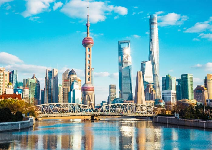
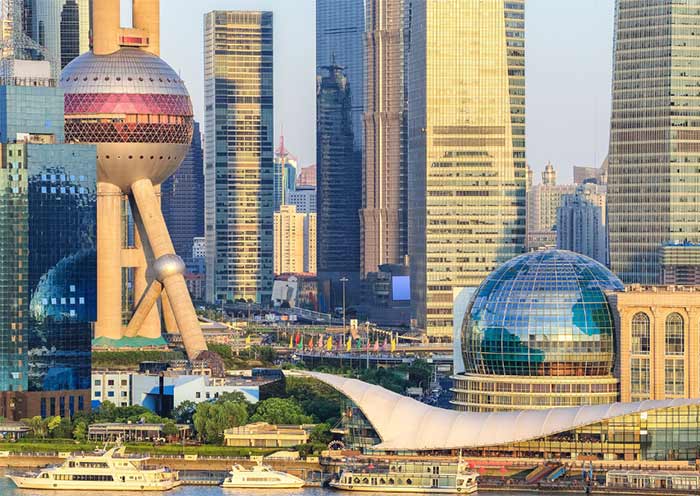
Day 1: Arrival in Shanghai
Day 2: Shanghai highlights
Day 3: High-speed train to Nanjing, Zhonghua Gate, Confucius Temple-Qinhuai Area
Day 4: Sun Yat-sen Mausoleum, Ming Xiaoling Mausoleum, Presidential Palace, departure
4 Days Shanghai Nanjing Highlight Tour by High-Speed Train
Shanghai - Nanjing