Jiangxi China Map: Jiangxi on the Map of China
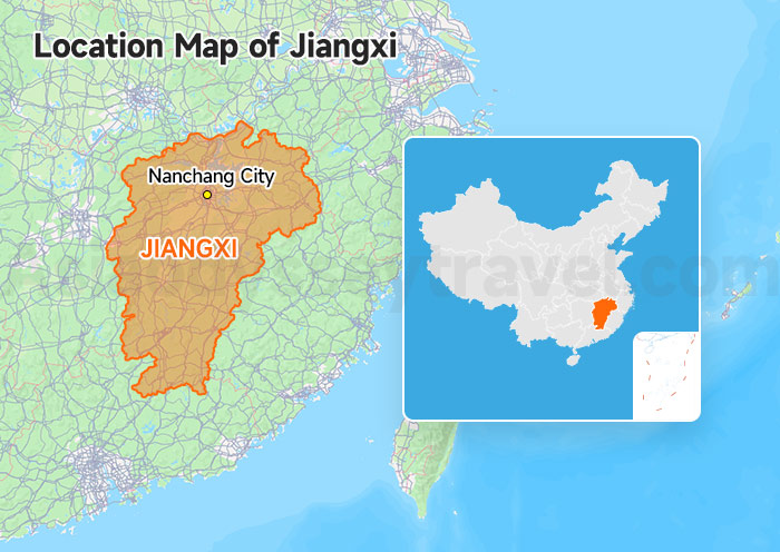
This overview map highlights Jiangxi within China, shows its general shape, and marks Nanchang, Poyang Lake. One of the first things this Jiangxi China map makes clear is the position of Nanchang (capital) in the central-north of the province.
Jiangxi is a landlocked province in east-central China. It sits south of the Yangtze River and is bordered by Zhejiang, Fujian, Guangdong, Hunan, Hubei, and Anhui.
Let's add a few quick travel distances (by high-speed train) to help you perfectly put its location into perspective for your itinerary:
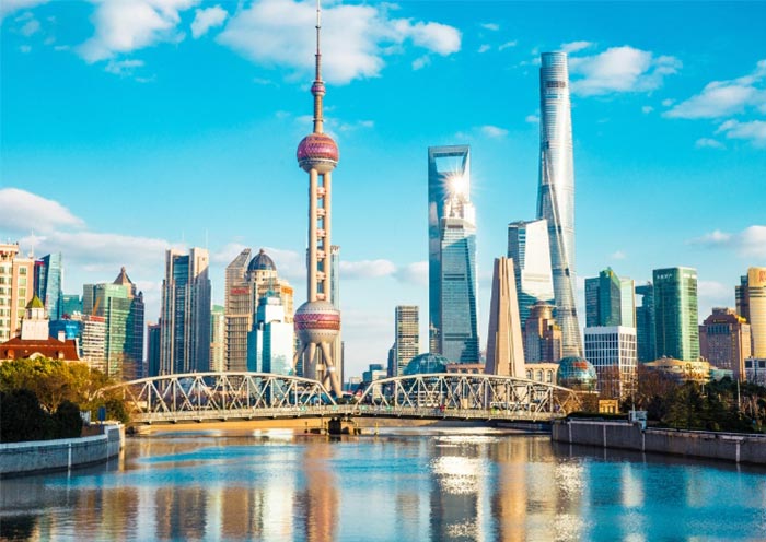
- To Shanghai: 3 hours
- To Guangzhou: 4 hours
- To Beijing: 6 hours
- To Huangshan: 1 hour
- To Zhangjiajie: 5 hours
For travelers coming from eastern China, Shanghai is the easiest pairing. For those already moving west to east through China, Jiangxi can also fit naturally after Zhangjiajie.
The Jiangxi Province Map: 11 Cities, 6 Airports, and One Capital
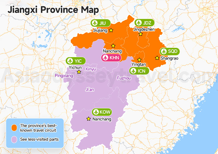
This Jiangxi province map outlines all 11 prefecture-level cities with English labels, marks the main airports, and distinguishes between the international gateway and the domestic airports.
Jiangxi is divided into 11 prefecture-level cities. Nanchang, the provincial capital, sits in the north-central part of the province.
The province's best-known travel circuit sits largely in the northeast. There are Jingdezhen, Shangrao, Yingtan, Jiujiang. It's best for first-time visitors.
| City | Description |
|---|---|
| Nanchang (南昌) | The provincial capital and main transport gateway |
| Jingdezhen (景德镇) | China's best-known porcelain city |
| Shangrao (上饶) | The key hub for Wangxian Valley, Lingshan Mountain & Gexian Village |
| Yingtan (鹰潭) | The access point for Longhushan |
| Jiujiang (九江) | The usual base for visiting Lushan |
The remaining cities - Ganzhou, Yichun, Pingxiang, Xinyu, Fuzhou, and Ji'an - make more sense for travelers with extra time, specific hiking interests, or a desire to see less-visited parts of the province.
Jiangxi Airports: Nanchang (KHN) & Other Domestic Airports
Only one airport in Jiangxi has international routes (Nanchang KHN - Bangkok, Singapore, KL). The other five are domestic.
| Airport | Drop you at the doorstep of |
|---|---|
| KHN Nanchang Changbei | Tengwang Pavilion, Lushan (via 1h HSR) |
| SQD Shangrao Sanqingshan | Sanqingshan, Wuyuan, Wangxian - the northeast cluster |
| JDZ Jingdezhen Luojia | Porcelain district, straight in |
| JIU Jiujiang Lushan | Mount Lushan - 1h taxi to Guling Town |
| KOW Ganzhou Huangjin | Hakka walled villages, southern Jiangxi |
| YIC Yichun Mingyueshan | Mount Wugong grassland camping |
For many overseas visitors, however, the more common pattern is still to enter China through a larger hub such as Shanghai, Guangzhou, or Hong Kong and then continue into Jiangxi by train or domestic flight.
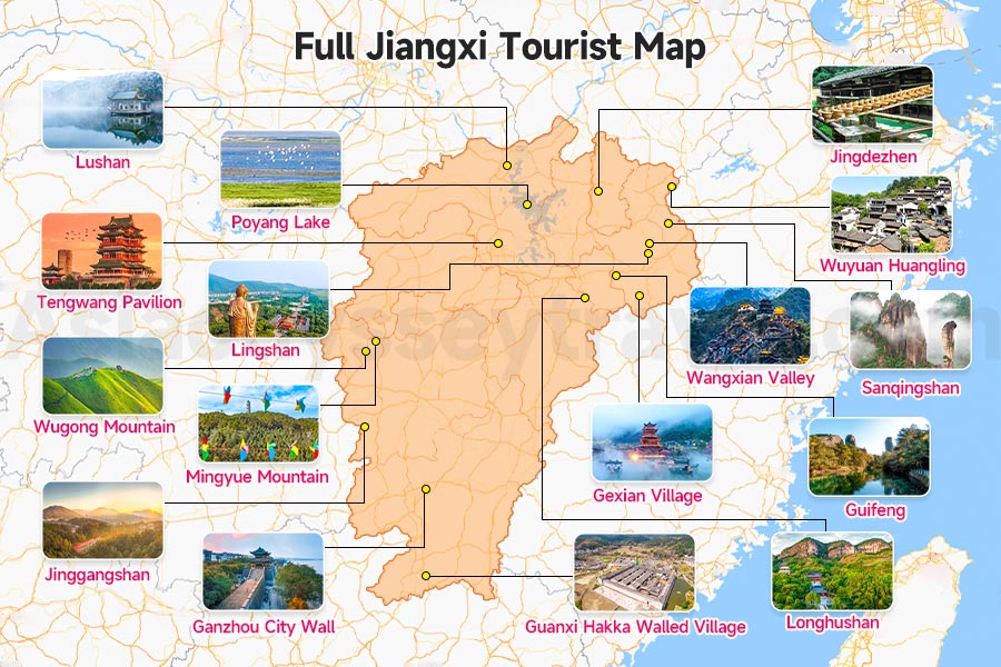
Full Jiangxi Tourist Map: 16 Places to See in Jiangxi
Maybe before seeing the first two maps, Jiangxi felt unfamiliar to you.
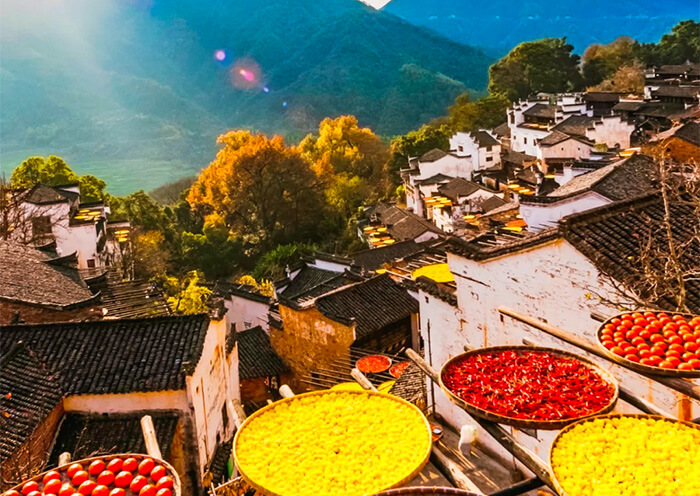
Wangxian Valley, the autumn harvest drying at Wuyuan Huangling, Lingshan with the world's longest outdoor mountain-climbing escalator at 753.2 meters, and Gexian Village - all viral on social media. They are all in Jiangxi.
So what else does Jiangxi have? UNESCO-listed Taoist mountains, thousand-year-old poetry landscapes, the world's porcelain capital, and China's largest freshwater lake.
Use the full Jiangxi Tourist Map below to see where all 16 places are and how they connect.
The 16 Must-Know Attractions at a Glance
- UNESCO & Sacred Mountains: Sanqingshan (world-famous granite fairy peaks & Taoist paradise), Lushan (famous in Chinese poetry for over a thousand years), Longhushan (Taoist holy mountain).
- Viral on Social Media: Wangxian Valley (cliffside village), Wuyuan Huangling (terraced farming), Lingshan (sky-high cliff escalator), Gexian Village (nighttime lanterns).
- Culture & History: Jingdezhen (Porcelain Capital), Tengwang Pavilion (Nanchang's pride), Guifeng (unique turtle-shaped Danxia rock formations), Ganzhou City Wall, Guanxi Hakka Walled Village.
- Nature & Hiking: Poyang Lake (world's largest winter habitat for migratory birds), Mingyue Mountain (hot springs), Wugong Mountain (alpine meadows), Jinggangshan (bamboo forests).
The Northeast Jiangxi Tourist Map with Distance: Where 80% of First-time Travelers Actually Go
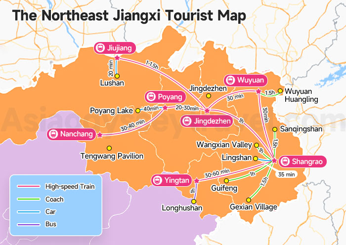
If you look closely at the map above, you will notice that most of Jiangxi's highlights are clustered in the northeast.
Since that is where most travelers actually go, we zoomed in on the northeast section and added distances between spots - so you can plan your Jiangxi trip more easily.
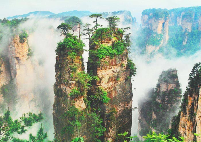
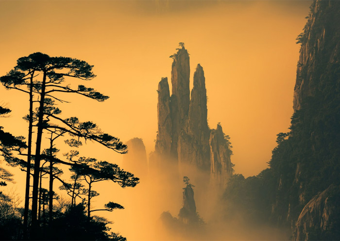
Sanqingshan (三清山): UNESCO-site. Magnificent granite peak wonderland, renowned as the most beautiful granite landscape in Western Pacific.
Lushan (庐山): UNESCO-site. Legendary poetic mountain of China, boasting misty waterfalls and well-preserved early 20th-century foreign villas.
Longhushan (龙虎山): UNESCO-site. The global ancestral cradle of Chinese Taoism, featuring spectacular Danxia landforms and tranquil river rafting.
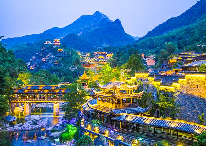
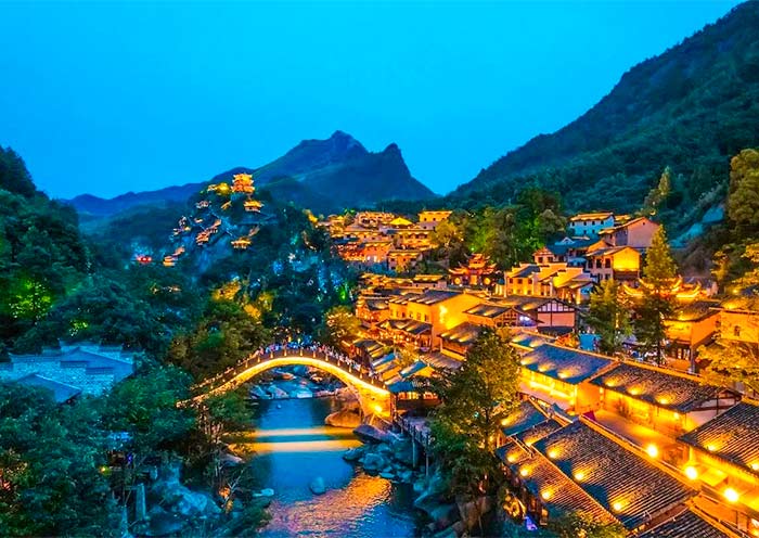
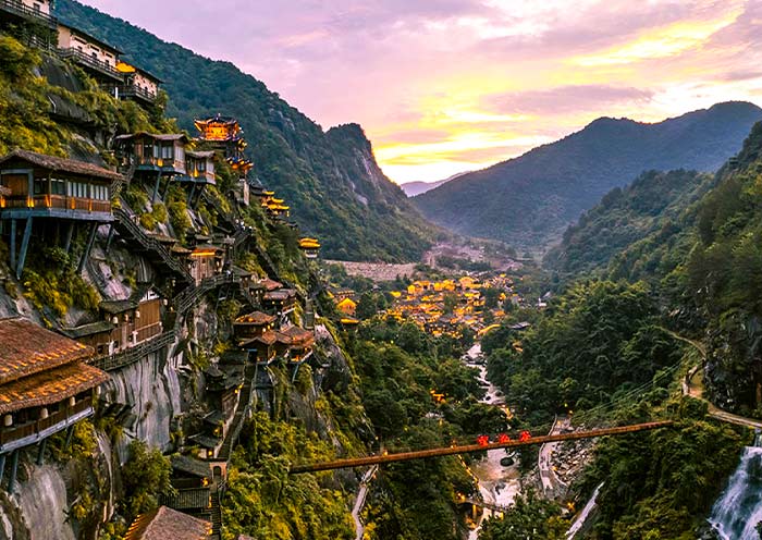
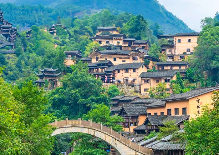
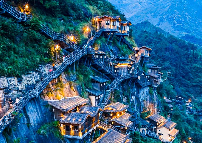
Wangxian Valley (望仙谷): Enchanting floating cliff village famous for breathtaking night scenery.
Wuyuan Huangling (婺源篁岭): UN-recognized World's Best Tourism Village, iconic for terraced farmland and primitive rural beauty.
Lingshan (灵山): Unique winding mountain range with the world's longest outdoor cliff escalator.
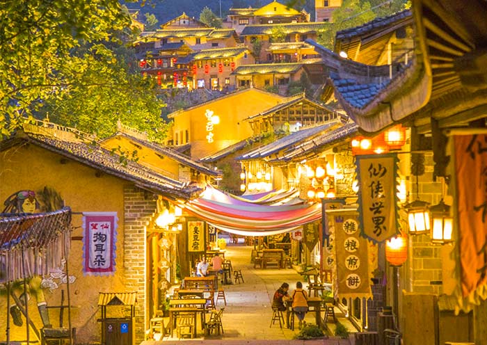
Gexian Village (葛仙村): Mythical Chinese Xianxia fairy valley famed for stunning all-valley lantern night views.
Jingdezhen (景德镇): The world's sole millennial Porcelain Capital and global origin of ceramic culture.
Tengwang Pavilion (滕王阁): One of China's Four Great Ancient Towers, immortalized by world-famous classical poetry.
Guifeng (龟峰): Distinctive Danxia scenic area with distinctive turtle-shaped rock formations.
Poyang Lake (鄱阳湖): Asia's largest freshwater lake and world-famous migratory bird sanctuary.
We have marked all attractions and distances between them on the map. Shangrao is the main transport hub in northeast Jiangxi. Yingtan, Wuyuan, Poyang, Jingdezhen North, and Jiujiang are the high-speed rail stations you are most likely to use.
Four Close-Up Maps for First-Time Visitors: Sanqingshan, Lushan, Huangling, and Wangxian Valley
These close-up maps focus on four of Jiangxi's most important first-trip sights, showing routes, entrance areas, cable cars, overnight zones, and the main things visitors should not miss.
Mount Sanqingshan - The Cable Car + Ridge Walk
It needs one full day. Take the South Cable Car up, walk the eastern ridge loop (the "Sunshine Coast" trail), pass the famous "Goddess Peak" rock, loop back via the western cliffs, and descend by the Goldsand Cable Car. You gain the best views without climbing 7,000 steps.
Mount Lushan
ushan is a plateau, not a single peak. Sleep on the mountain in Guling Town.
- Day one: the west loop - Jinxiu Valley, Fairy Cavern, Dragon Pool.
- Day two: the east loop - Five Old Men Peak, Hanpo Pass, Lulin Lake.
Wuyuan Huangling - Most Visited Ancient Village
Huangling is visually compact but highly seasonal. It is best known for the drying-rack scenery and the hillside village setting.
A close-up map is useful mainly for orientation: where the cable car arrives, where the best viewpoints are, and how much walking the main route actually involves.
Wangxian Valley Map - Detailed Tourist Map
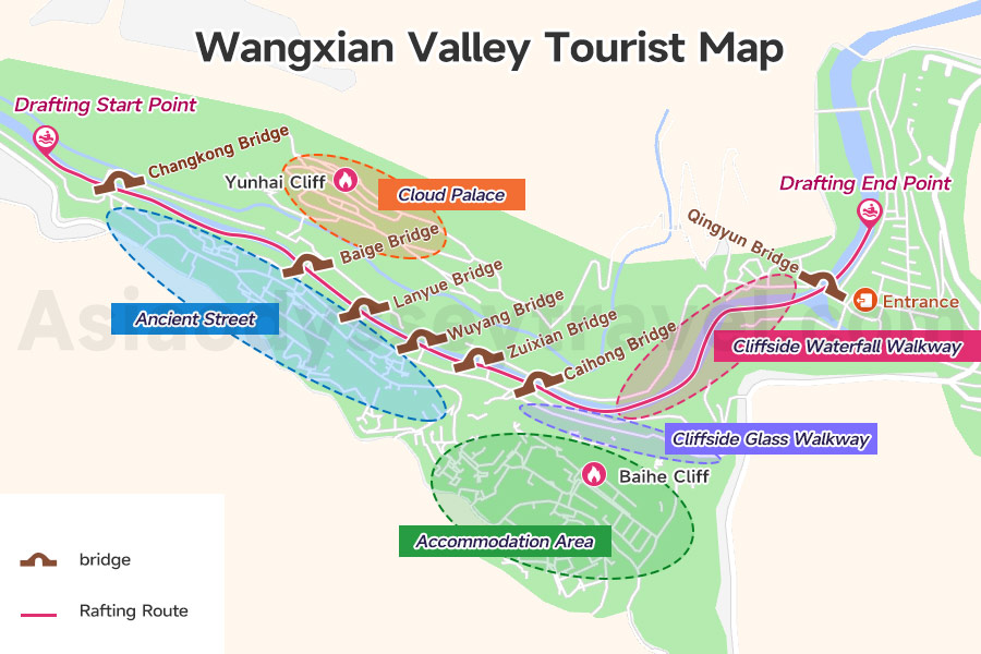
Wangxian Valley is a rising theme park built around a cliff-side village. The detailed visitor map we provide here clearly marks the scenic area entrance, accommodation zones, the ancient street, the rafting route, and the star attraction - Baihe Cliff (云海崖).
Wangxian Valley Map, How to Visit Wangxian Valley with Map
The Jiangxi High-Speed Rail Map: The Single Best Way to Travel
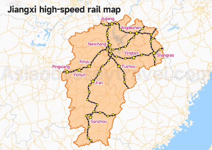
This Jiangxi high-speed rail map highlights the major lines running through the province, the main tourist stops, and the connections most relevant to travelers. In the northeast especially, several major sights can be linked by short train rides plus local shuttle transfers.
The 6 HSR Routes You'll Actually Use as a Tourist:
- Nanchang ↔ Shangrao (1 hr)
- Shangrao ↔ Wuyuan (30 min)
- Wuyuan ↔ Jingdezhen (30 min)
- Jingdezhen ↔ Jiujiang (1 hr)
- Nanchang ↔ Jiujiang (1 hr)
- Nanchang ↔ Ganzhou (2 hrs)
- Trip.com - simple English-language interface and straightforward passport booking
- 12306 - the official rail platform, often cheaper but less intuitive for first-time users
Trains get you to the cities, but mountains are usually an hour outside town. stations like Shangrao, there are direct tourist shuttle buses (景区直通车) waiting in the parking lot. You can usually buy these tickets on the spot by scanning a QR code or paying cash.
The Jiangxi Food & Spice Map: How Hot Is "Too Hot"?
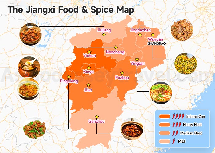
Now let's talk about food. When traveling, you always want to try something local. If you love spicy food, this place is paradise. If you can't handle spice, eating here takes some planning.
Our food map uses spice level as the base layer and highlights local dishes by city. Rice noodles are worth trying anywhere in the province - toppings vary by city, but they are always good.
The Jiangxi Spice Map, City by City
Inferno Zone: Pingxiang, Yichun, Xinyu
Heavy Heat: Fuzhou, Ji'an
Medium Heat: Yingtan, Jingdezhen, Shangrao, Nanchang
Mild: Jiujiang, Ganzhou
Must-Try Dishes by Region
| City | Dishes |
|---|---|
| Nanchang | Clay-pot soup (瓦罐汤) + Mixed rice noodles (拌粉) |
| Ganzhou | Three-cup chicken (三杯鸡) |
| Pingxiang | Stir-fried pork with chili (小炒肉) |
| Jiujiang | Fermented-rice fish (酒糟鱼) |
| Wuyuan | Steamed dishes (婺源蒸菜) |
| Jingdezhen | Alkaline rice cake (碱水粑) |
| Yingtan | Beef rice noodles (牛肉粉) |
Clay-pot soup and three-cup chicken are mild and available everywhere. Learn one phrase - "bù yào là" (不要辣) - meaning "no spice please." Cities like Nanchang and Shangrao also have McDonald's.
3 Jiangxi Itinerary Maps: Real Jiangxi Trips You Can Copy
The maps in this section are the ones you will actually save to your planning doc. They visualize the three most popular routes through Jiangxi.
- 6-Day Jiangxi Itinerary Map - A focused loop through northeast Jiangxi covering Shangrao, Jingdezhen, Wuyuan, and Huangshan. Best for repeat visitors to China who have already seen Beijing and Shanghai.
- 8-Day Shanghai to Jiangxi Itinerary Map - A route from Shanghai through Hangzhou, Wangxian Valley, and Huangshan. Best for first-time visitors who want to hit eastern China's top highlights in one trip.
- 8-Day Zhangjiajie to Jiangxi Itinerary Map - A route connecting Zhangjiajie, Wangxian Valley, and Huangshan. Best as an add-on for travelers already planning a Zhangjiajie trip.
6-Day Northeast Jiangxi Loop Map

| Day | Itinerary |
|---|---|
| 1 | Arrive in Shangrao |
| 2 | Shangrao to Jingdezhen. Ancient Kiln & Folk Customs Museum, DIY Ceramics, Taoxichuan Ceramic Art Avenue |
| 3 | Jingdezhen to Wuyuan to Huangshan. China Ceramics Museum, Huangling Village |
| 4 | Huangshan. Hongcun Village, Yellow Mountain |
| 5 | Huangshan. Mount Huangshan, Tunxi Old Street |
| 6 | Huangshan departure. Hotel check-out and see-off |
6 Days Trendiest East China Tour: Wangxian Valley Jingdezhen Wuyuan Huangshan
Shangrao - Wangxian Valley - Jingdezhen - Wuyuan - Huangshan
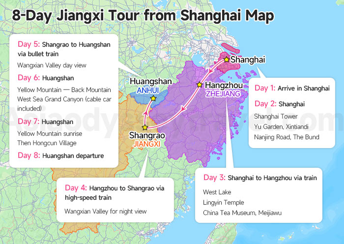
8-Day Jiangxi Tour from Shanghai Map
| Day | Itinerary |
|---|---|
| 1 | Arrive in Shanghai. Airport pick-up and hotel check-in |
| 2 | Shanghai. Shanghai Tower, Yu Garden, Xintiandi, Nanjing Road, The Bund |
| 3 | Shanghai to Hangzhou via train. West Lake, Lingyin Temple, China Tea Museum, Meijiawu |
| 4 | Hangzhou to Shangrao via high-speed train. Transfer to Wangxian Valley for night view |
| 5 | Shangrao to Huangshan via bullet train. Wangxian Valley day view |
| 6 | Huangshan. Yellow Mountain - Back Mountain, West Sea Grand Canyon (cable car included) |
| 7 | Huangshan. Yellow Mountain sunrise, then Hongcun Village |
| 8 | Huangshan departure. |
How to Get to Wangxian Valley from Shanghai? Bullet Train Guide
8 Days Shanghai Jiangnan Tour with Rising Star Wangxian Valley
Shanghai - Hangzhou - Shangrao (Wangxian Valley) - Huangshan
8-Day Jiangxi Tour from Zhangjiajie Map
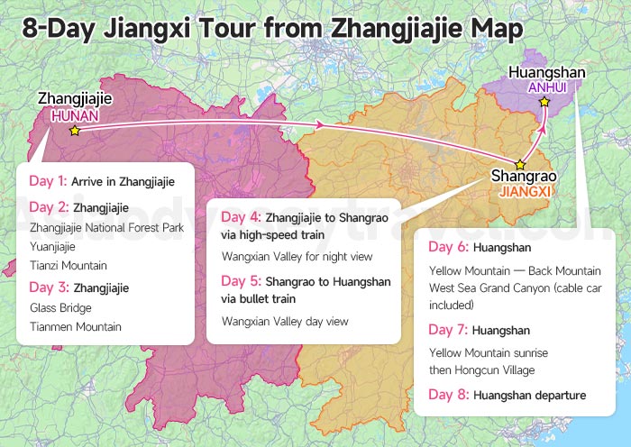
| Day | Itinerary |
|---|---|
| 1 | Arrive in Zhangjiajie |
| 2 | Zhangjiajie National Forest Park. Yuanjiajie and Tianzi Mountain |
| 3 | Zhangjiajie. Glass Bridge, Tianmen Mountain |
| 4 | Zhangjiajie to Shangrao via high-speed train. Transfer to Wangxian Valley for night view |
| 5 | Shangrao to Huangshan via bullet train. Wangxian Valley day view |
| 6 | Huangshan. Yellow Mountain - Back Mountain, West Sea Grand Canyon (cable car included) |
| 7 | Huangshan. Yellow Mountain sunrise, then Hongcun Village |
| 8 | Huangshan departure. Hotel check-out and see-off |
How to Travel from Zhangjiajie to Wangxian Valley (Avatar to Xianxia)
8 Days China Fantasy Tour: Zhangjiajie to Wangxian Valley & Huangshan
Zhangjiajie - Shangrao (Wangxian Valley) - Huangshan
Travel Jiangxi with Asia Odyssey Travel - Where Maps End, We Begin
Maps plan the route; we handle everything the map can't show.
For 15 years, Asia Odyssey Travel has built private journeys across China for travelers who refuse the tour-bus version of the world - scholars, families, photographers, first-time visitors who simply want it done right.
Send us the maps above that moved you. We will turn them into the trip you remember for the rest of your life.