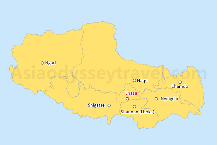
Nyingchi Tibet Map: Overview in Tibet
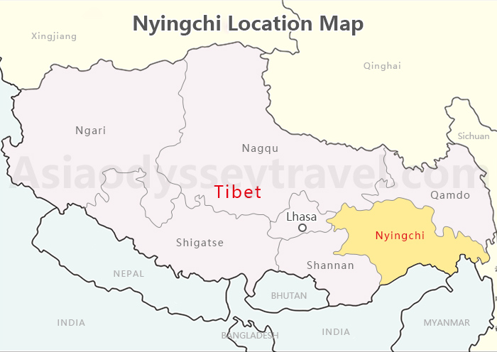
This Nyingchi Tibet map shows you exactly where it sits: southeastern Tibet at 29.65°N, 94.36°E, about 400km from Lhasa, bordering Sichuan and India.
What makes Nyingchi different? It averages just 3,100 meters elevation—much lower than the rest of Tibet. That means lush valleys and forests instead of barren plateau, and way gentler acclimatization.
Most travelers fly here first, spend a few days adjusting, then head to Lhasa's higher elevations without the headache.
The scenery alone is worth the stop. Turquoise Basum Lake, endless Lulang forests, and Namcha Barwa—one of China's most stunning snow peaks—earn Nyingchi its "Switzerland of Tibet" nickname.
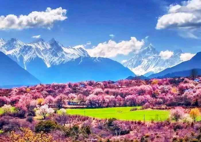
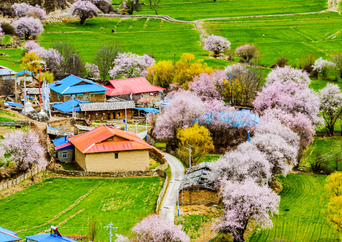
The legendary G318 highway cuts right through here connecting Chengdu to Lhasa, which is why road trippers camp out every spring for those Instagram-famous wild peach blossoms.
Nyingchi Prefecture Map: (Districts & Counties)
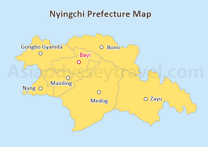
Here's where it gets confusing: what's now called Nyingchi City used to be Nyingchi Prefecture. This Nyingchi prefecture map breaks down what that actually means on the ground.
Nyingchi consists of one district and six counties, but only three matter for travelers. Bayi District is where you'll stay—it's the government seat and has all the hotels, restaurants, and transport hubs. Think of it as "downtown Nyingchi."
Northwest, Gongbo'gyamda County holds Basum Lake, a sacred lake surrounded by snow-capped mountains and ancient monasteries.
Northeast, Bomi County has the famous peach blossom valleys and Midui Glacier. In March and April, Bomi is magical. Thousands of peach trees bloom pink against a backdrop of snow mountains.
These three areas cover what most tourists actually visit. The other counties? They exist on the map, but limited infrastructure means they're off most itineraries.
Nyingchi City Map: Bayi District, Airport & Railway Station
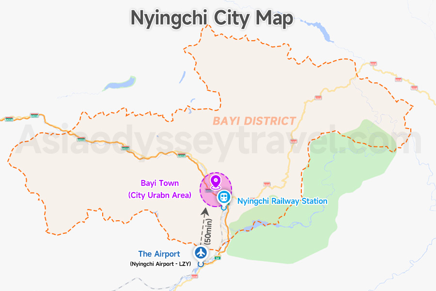
Nyingchi City, specifically the administrative center known as Bayi District, is the modern hub of the prefecture. As shown in the Nyingchi City map, Bayi Town (downtown of Nyingchi City) is well-connected and serves as the primary base for tourists.
Nyingchi Mainling Airport (LZY): Located in Mainling County, about 50km from Bayi District. It connects Nyingchi City with major Chinese cities like Chengdu and Chongqing.
Nyingchi Railway Station: A key stop on the Lhasa-Nyingchi Railway. It is located roughly 19km from downtown Bayi, offering a 3.5-hour high speed train link to Lhasa.
Nyingchi Tourist Map: Top Attractions in Nyingchi Tibet
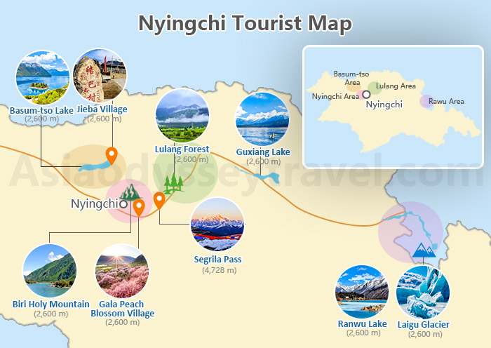
Our Nyingchi tourist map highlights the must-visit destinations scattered across the prefecture. Since Nyingchi covers a vast area, understanding the location of these top attractions is vital for your itinerary:
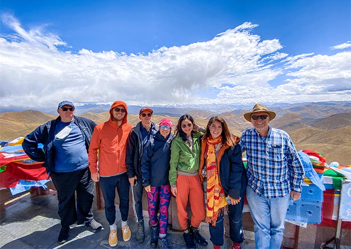
Segrila Pass (4,728m): Experience breathtaking views at this high-altitude mountain pass, offering spectacular vistas of snow-capped peaks and serving as a dramatic gateway between Nyingchi and Lhasa.
Lulang Forest (2,600 m): Known as the "Little Switzerland of Tibet," this pristine forest at 3,700m features meadows, pine forests, and snow-topped mountains. The viewing platform offers stunning panoramas of the entire valley.
Basum-tso Lake (2,600 m): This sacred alpine lake at 3,700m is surrounded by snow-capped mountains and ancient monasteries. The crystal-clear waters reflect the surrounding peaks, creating perfect photo opportunities.
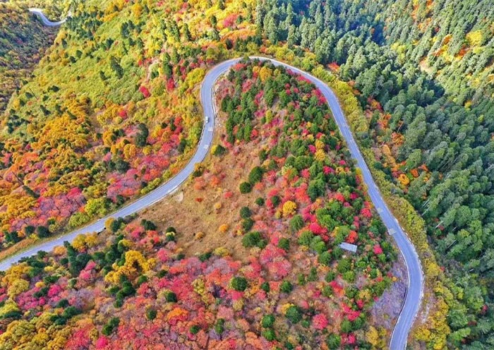
Gala Peach Blossom Village (2,600 m): Visit between March and April to witness the spectacular display of peach blossoms that blanket the valley in pink, set against snow-mountain backdrops. This village has earned fame as one of China's most beautiful spring destinations.
Ranwu Lake (2,600 m): The largest lake in eastern Tibet offers stunning views of glaciers, snow mountains, and forests. The surrounding area is perfect for photography and hiking.
Laigu Glacier (2,600 m): One of Tibet's most accessible glaciers, offering visitors a chance to witness the magnificent ice formations and understand the region's geological history.
Jieba Village (2,600 m): Experience authentic Tibetan village life and traditional architecture in this well-preserved settlement, known for its distinctive local customs and friendly residents.
Biri Holy Mountain (2,600 m): A sacred peak in Tibetan Buddhism, offering hiking opportunities and cultural insights into local religious practices.
Guxiang Lake (2,600 m): A serene alpine lake surrounded by primitive forests, providing excellent opportunities for nature photography and peaceful contemplation.
Map of Nyingchi Peach Blossom Festival (March-April)
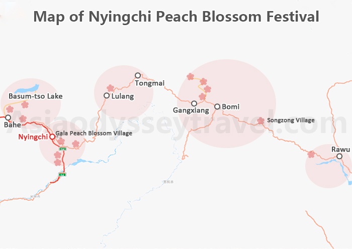
Nyingchi's peach blossom viewing spots scatter across four counties, with bloom timing varying by elevation. This Nyingchi peach blossom festival map is essential for March-April visitors.
It pinpoints the best photography locations: Gala Village (most famous, 2,900m), Bomi Valley (largest area, 2,740m), Zaxigang Village (alpine meadow setting, 3,300m), and Guxiang Lake (lake reflections, 2,600m).
Key Viewing Locations
Gala Peach Blossom Village (2,900 m): The festival's centerpiece and most famous location, featuring vast orchards of wild peach trees set against the backdrop of snow-covered mountains. The village's elevation of 2,800 meters creates a unique microclimate perfect for peach blossoms.
Guxiang Lake (2,600 m): Offers a magical combination of peach blossoms reflected in the crystal-clear alpine lake, with snow peaks completing the picture. The lakeside hiking trails provide excellent photography opportunities.
Bomi Peach Blossom Valley (2,740 m): Known for having the largest concentration of wild peach trees in Tibet, this valley presents a sea of pink blossoms stretching for kilometers along the Parlung Tsangpo River.
Zaxigang Village (3,300 m): Located in Lulang Town, is a vibrant paradise where peach blossoms spread across alpine meadows, through forests, and along lakeshores during spring, creating a colorful natural tapestry against the backdrop of snow-capped mountains.
Basum-tso Lake (3,490 m): While primarily known for its turquoise waters and surrounding mountains, the lake area features scattered peach groves that create beautiful reflections in the sacred lake's surface during the festival period.
Nyingchi Transportation Maps: How to Get to Nyingchi
Nyingchi acts as the vital eastern gateway to Tibet. Our Nyingchi Transportation Map visualizes the strategic "Golden Triangle" connecting Lhasa, Nyingchi, and Chengdu.
These maps are essential for optimizing your itinerary, helping you visualize the stark contrast between the efficient Lhasa-Nyingchi Railway and the winding, scenic marvel of the G318 National Highway.
Lhasa to Nyingchi Map
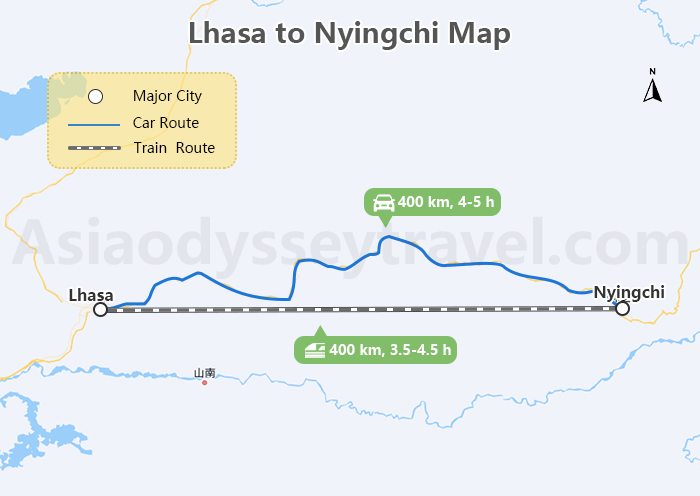
By Train: The rail connection between Lhasa and Nyingchi offers two daily options for travelers. The high-speed service completes the journey in just 3.5 hours, while the regular train takes 4.5 hours, with each service operating one departure per day.
Private Car Service:
By Private Car: The journey from Lhasa to Nyingchi by private car typically takes 4-5 hours, though travel time can vary depending on weather conditions and stops along the way. Covering approximately 400 kilometers along the Lhasa-Nyingchi Highway, this service is readily available through local travel agencies like Asia Odyssey Travel.
Lhasa to Nyingchi Bullet Train: Schedule, Tickets & Travel Tips
Chengdu to Nyingchi Overland Map
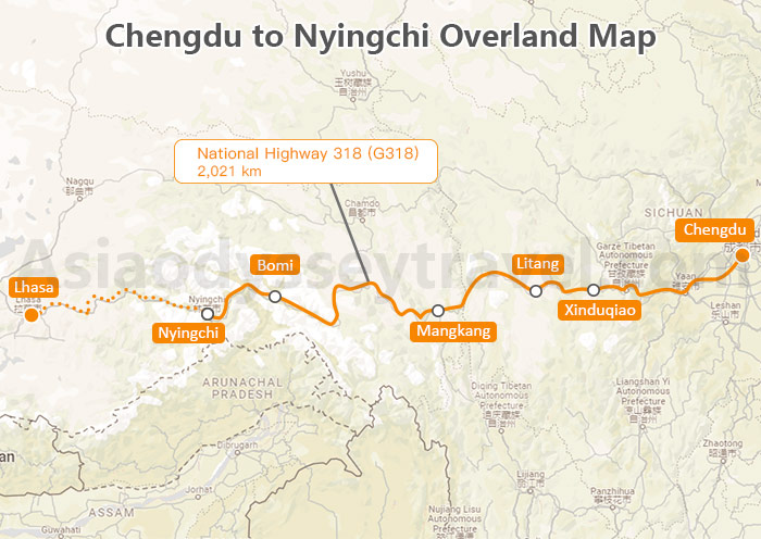
The legendary National Highway 318 (G318), stretching 2,021 kilometers from Chengdu to Nyingchi, is renowned as one of China's most breathtaking road trips.
While not a conventional transportation choice for most travelers, this iconic route offers an extraordinary journey through diverse landscapes, from the Sichuan Basin through numerous mountain ranges and deep river valleys of Eastern Tibet.
The route showcases dramatic elevation changes, winding mountain passes, and stunning vistas that have earned it recognition as one of China's most scenic highway adventures.
How to Plan Sichuan Tibet Trip via G318
How to Plan a Nyingchi Tibet Tour

Travel Permits
The Tibet Travel Permit is mandatory for all foreign visitors and can only be obtained through authorized travel agencies. Asia Odyssey Travel provides complimentary permit application services when you book either our Tibet group tours or private tours to Tibet.
How Long to Stay in Nyingchi
A classic visit to Nyingchi typically requires 2-3 days to fully experience its natural beauty and cultural attractions. This allows sufficient time to explore major highlights while acclimating to the altitude. The first day focuses on gentle activities in Bayi Town, followed by visits to attractions like Lulang Forest, Lake Basum Tso, or the Midui Glacier on subsequent days, depending on the season.

Popular Combined Itineraries
- Nyingchi + Lhasa (6 Days):
Perfect for first-time visitors wanting to experience both Tibet's natural landscapes and cultural heritage.
- Nyingchi + Lhasa + Everest Base Camp (10-12 Days):
Comprehensive journey combining natural scenery, cultural sites, and the majestic Mount Everest.
- Lhasa + Nyingchi + Shigatse (8-9 Days):
Ideal route covering Tibet's three major cities, offering a blend of natural beauty, historical sites, and Tibetan culture.
Explore Tibet with Asia Odyssey Travel (AOT)
Discover Tibet's wonders stress-free with Asia Odyssey Travel! We handle permits, craft personalized itineraries, and pair you with expert local guides. From Everest treks to Lhasa's sacred sites, enjoy safe, authentic journeys with 15+ years of trusted expertise.
✅ Complete Tibet Tours - Explore all of Tibet with expert guides and full permit support.
✅ Budget-Friendly Packages - Small Group Tibet Tours at the Best Prices.
✅ Lhasa Highlights - Lhasa Tours covering Potala Palace, Jokhang Temple, and monastery day trips
✅ Beyond Lhasa: Everest Base Camp Tours · Mount Kailash Tours · Shigatse Tours · Overland Routes to Nepal
Useful Tibet Travel Guide: Tibet Travel Guide, Tibet Travel Tips
")
")
")
")
")
: Tourist Map of Ngari Tibet")