Jiankou Great Wall Map for Location: Where It Located
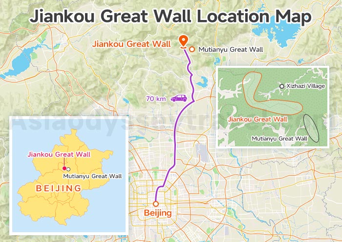
This map shows the location of Jiankou and its connection to other Great Wall sections near Beijing.
Jiankou is located in Huairou District, about 70 km northwest of downtown Beijing. It lies west of Mutianyu Great Wall and can be reached on foot via the eastern part of Jiankou Great Wall.
On the map you can see:
- The position of Jiankou relative to central Beijing
- Major roads and approximate driving route
- Distance and direction to Mutianyu Great Wall
- Nearest villages: Xizhazi Village (main hiking access)
Jiankou Great Wall Transportation Map: How to Get There?
Jiankou is not a standard tourist scenic area, but a wild, unrestored section of the Great Wall mainly for hiking.
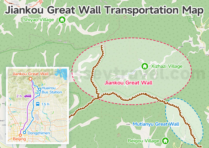
Hiking starts from villages at the foot of the mountain:
- South Trailhead: Xizhazi Village (Xizhazi Cun) – most common, 1–1.5hrs hike up to Jiankou Spot / Zhengbei Tower
- North Trailhead: Beigou Village (Beigou Cun) – shorter climb, connects to Ox Horn Edge / Mutianyu
- West Trailhead: Shiyao Village (Shiyao Cun) – access to Nine-Eye Tower / Beijing Knot (longest approach)
There is no direct public transportation to the wall itself — you must hike up from one of these villages.
By Car (Recommended & Most Efficient)
Take a private car or tour bus from Beijing. It takes about 2 hours to Xizhazi Village or Beigou Village.
After you finish your hike and come down from the wall (usually at Mutianyu), your driver can wait for you at the Mutianyu parking lot.
By Public Bus
Take Bus 916 Express from Dongzhimen to Huairou Bus Station (about 1.5 hours). Then transfer to a local minibus or taxi to Xizhazi Village (about 40 minutes, ¥80–150 one way).
Again, there are no direct buses or shuttle services to the wall — you will need to hike uphill from the village.
- Driving time from Beijing: about 2 hours
- No direct public transport to the wall; you must hike from the village
- East Jiankou connects to Mutianyu; West Jiankou is more remote and dangerous
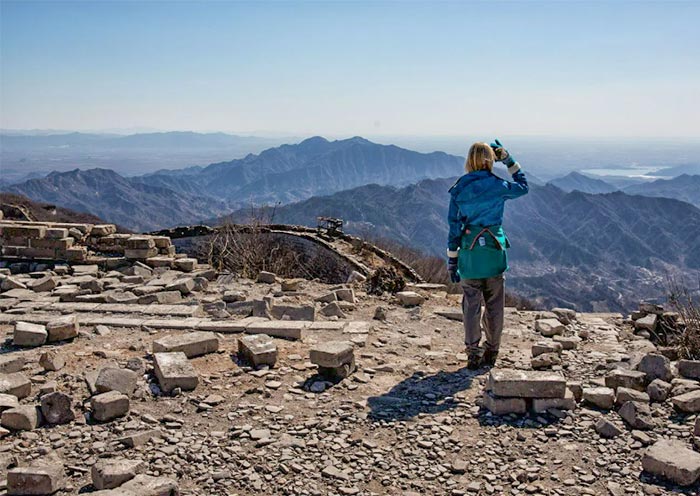
Jiankou Great Wall Map for Layout & Sightseeing
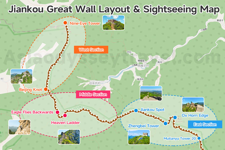
This map shows the full extent of Jiankou Great Wall, stretching from Nine-Eye Tower in the west all the way to Mutianyu Great Wall in the east.
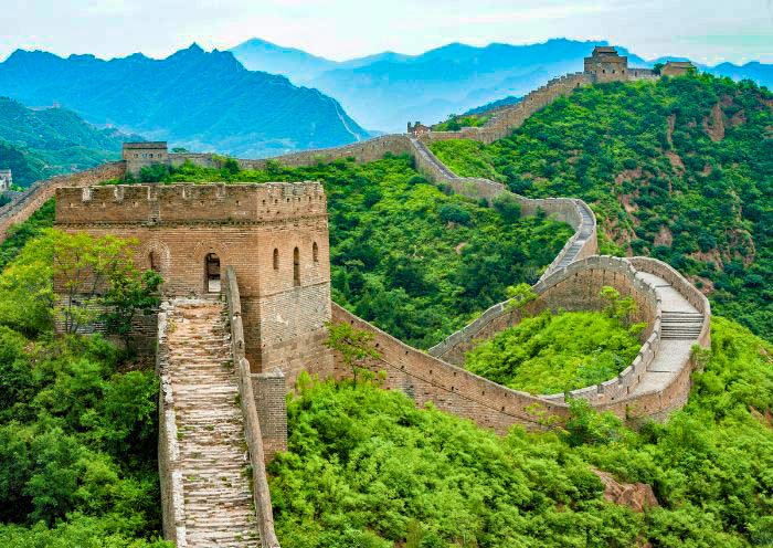
As you can see from the map, the mountain ridge where the wall was built resembles a drawn bow, with a collapsed gap forming the narrow notch — this is how Jiankou got its name. Jiankou translates to "Arrow Nock" in English.
Jinshanling Great Wall - A Paradise for Photographers and Hikers
On the map you can see:
- Nine-Eye Tower (Jiuyanlou): Western end, multi-windowed tower, highest in Beijing Great Wall
- Beijing Knot (Beijingjie): Three Great Wall branches meet, highest & most iconic point
- Eagle Flies Backwards (Yingfeidaoyang): Most dangerous section, overhanging cliff, requires climbing
- Heaven Ladder (Tianti): 80° steep stone steps, narrow, no handrails
- Jiankou Spot (Jiankouliang): collapsed tower marks the dividing line between the eastern and western sections
- Zhengbei Tower (Zhengbeilou): Largest intact watchtower, highest spot
- Ox Horn Edge (Niujiaobian): Curved ridge section, connects to Mutianyu Tower 20
West Section: Nine-Eye Tower → Beijing Knot → Eagle Flies Backwards (most challenging, steep cliffs)
Middle Section: Eagle Flies Backwards → Heaven Ladder → Jiankou Spot (most dangerous core)
East Section: Jiankou Spot → Zhengbei Tower → Ox Horn Edge → Mutianyu Tower 20 (easier, popular for day hikes)
Recommended Hiking Routes (Map-Based Itineraries)
The main section of the wall was built along the ridges with steep cliffs on each side. Therefore, you have to prepare for a good fitness and great care if you climb this section.
1. Classic Easy Day Hike – For Intermediate Hikers
| Route | Distance | Time | Difficulty |
|---|---|---|---|
| East Section | 6–8 km | 4–5 hrs | ★★★☆☆ |
Direction: Xizhazi Village → Jiankou Spot → Zhengbei Tower → Ox Horn Edge → Mutianyu Tower 20 (exit via Mutianyu cable car/toboggan)
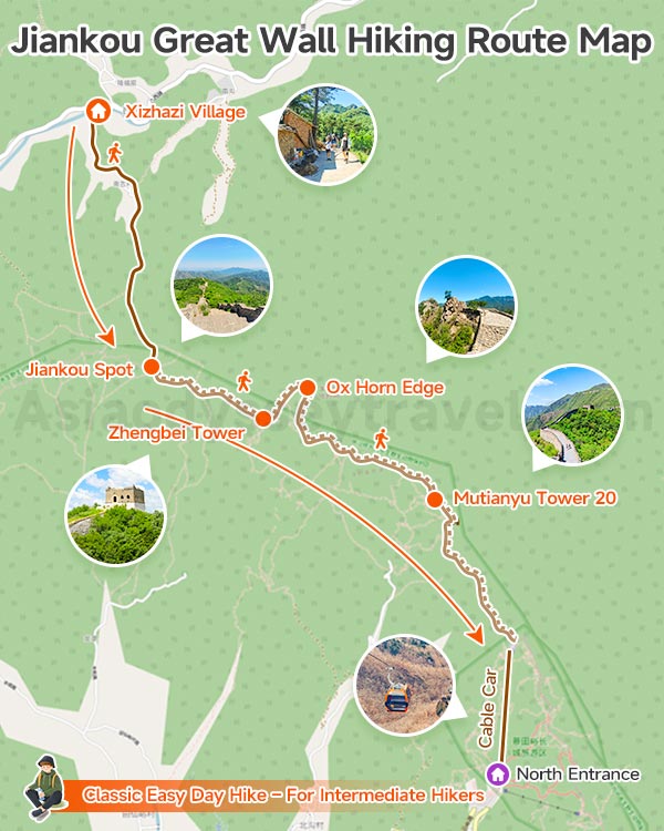
This is the most popular and standard Jiankou route.
Start from Xizhazi Village and follow a forest trail up to Jiankou Spot. The entrance can be hard to find, so a local guide is highly recommended.
From Jiankou Spot, head east along the ruined wall. Watch for loose bricks and unstable stones.
You will pass the “mini Potala Palace” area — steep and challenging — before reaching Zhengbei Tower, the highest and most scenic point on the route.
It offers amazing views of the wall winding through the mountains, especially beautiful with spring apricot blossoms or autumn red leaves.
Continue east from Zhengbei Tower until you reach the highest tower of Mutianyu Great Wall.
Map Notes: Fewer cliffs, connects to developed Mutianyu for easy exit; best for first-time Jiankou hikers
2. Core Challenge Hike – For Advanced Hikers
| Route | Distance | Time | Difficulty |
|---|---|---|---|
| Middle Section | 4–5 km | 5–6 hrs | ★★★★☆ |
Direction: Xizhazi Village → Jiankou Spot → Eagle Flies Backwards → Heaven Ladder → Beijing Knot → return to village
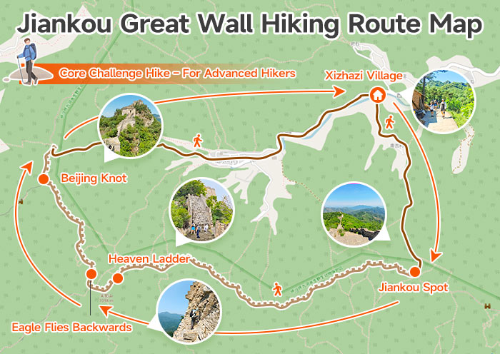
Start from Xizhazi Village and hike up to Jiankou Spot, then turn west.
In about 1–2 hours, you will reach Heaven Ladder — an almost vertical, 80° slope that requires serious climbing.
Next comes Eagle Flies Backwards, the most dangerous part of Jiankou. The wall is so steep that legend says even eagles must turn back. This section is more like unprotected rock climbing than hiking.
- Keep full focus, no photography
- Use both hands and feet
- Do not lean backward
- Keep distance from other hikers
This section is not suitable for inexperienced hikers, children under 12, or seniors.
Map Notes: Includes the most iconic & dangerous sections; never hike alone, hire a local guide
3. Full West-to-East Traverse (12–15km, 8–10hrs) – For Expert Hikers
| Route | Distance | Time | Difficulty |
|---|---|---|---|
| Full Section | 12–14 km | 8–10 hrs (1-2 days) | ★★★★★ |
Direction: Shiyao Village → Nine-Eye Tower → Beijing Knot → Heaven Ladder → Eagle Flies Backwards → Zhengbei Tower → Mutianyu
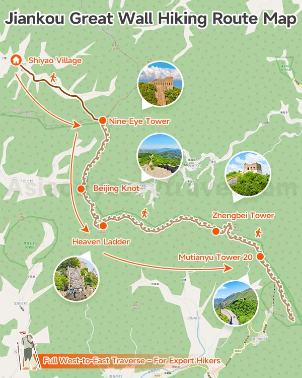
This is a full traverse of Jiankou for experienced hikers only.
You will cross the most extreme sections: Heaven Ladder, Eagle Flies Backwards, and exposed cliff paths. There are no shops, no water, no facilities along the entire route.
The hike takes a full day. For safety, you may split it into two days and stay overnight in Xizhazi Village. Avoid hiking after dark — it is extremely dangerous.
Map Notes: Complete Jiankou adventure. Requires thorough preparation, early start, local guide, and clear exit plan via Mutianyu.
Safety & Rules for Hiking Jiankou Great Wall
No Solo Hiking: Always go with a group / hire a local experienced guide (¥200–300/day) – many accidents happen to solo hikers
Gear Must-Haves: Non-slip hiking boots, gloves (for climbing rough stones), knee pads, headlamp, 2L+ water, snacks, first-aid kit, rain gear
Danger Zones (Map Marked):
- Eagle Flies Backwards: Overhanging, loose stones – turn back if uncomfortable
- Heaven Ladder: 80° slope, narrow – use hands, no rushing
- Collapsed sections: Deep gaps, no handrails – avoid or cross carefully
No Facilities: No toilets, no shops, no shelter – bring everything you need
Best Time: Spring (April–May) / Autumn (September–October) – cool, clear views; avoid summer heat / winter ice
Jiankou Great Vs. Othr Sections of the Great Wall
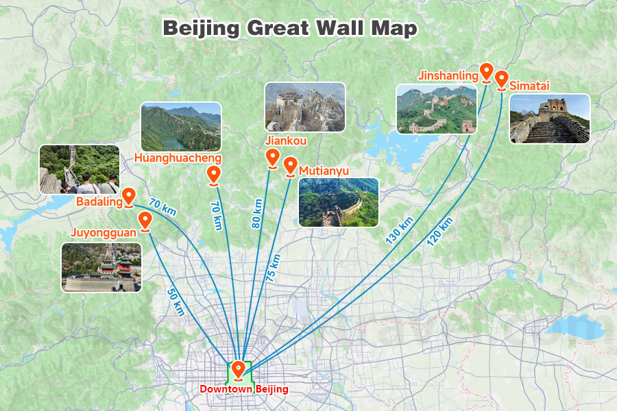
| Section | Distance from Beijing | Transport Time (One-way) | Key Highlights |
|---|---|---|---|
| Mutianyu | ~75 km | 1.5–2 hrs (bus/car) | 90% forest cover, cable car + toboggan, less crowded, wide gentle paths, Tower 14–20 (peak view) |
| Badaling | ~70 km | 1–1.5 hrs (bus/S2/high-speed rail) | Most famous, fully restored, best facilities, closest to city, most crowded, Accessible by bullet train |
| Jinshanling | ~130 km | 2.5–3 hrs (car/tour bus) | Original Ming structure, dense watchtowers, sunrise/sunset, few tourists, photo paradise |
| Simatai | ~120 km | 2.5–3 hrs (car) | Only original Ming wall open for night tours, steep & narrow, connected to Gubei Water Town |
| Jiankou | ~80 km | 2 hrs (car) | Wild & unrenovated, dramatic ridges, no facilities |
| Juyongguan | ~50 km | 1 hr (bus/car) | Circular wall, Yun Tai (ancient stone carvings), military fortress feel |
| Huanghuacheng Lakeside Great Wall | ~70 km | 1.5–2 hrs (car/bus) | Unique "Great Wall entering water" landscape, lake views, boat rides, quiet & scenic |