Location Map: Where is Badaling Great Wall on a Map
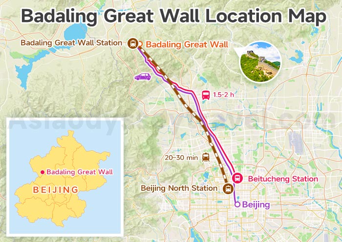
Badaling Great Wall (116.0168° E, 40.3562° N) is located 70km northwest of Beijing city center. On the map, you can see that Badaling just sits along the Beijing-Zhangjiakou high speed railway, making it a big advantage for tourists choosing Badaling section.
How to Get there?
By High-Speed Train (Fastest & Best)
Take the high-speed train from Beijingbei (Beijing North) Railway Station to Badaling Great Wall Station.
The ride only takes about 20–30 minutes, and the wall entrance is within a short walk from the station, about 10 minutes.
- Second Class: ¥25-28 (~$4)
- First Class: ¥40-45 (~$7)
- Business Class: ¥85 (~$13)
By Bus
Take Bus 877 from Beitucheng Station (Metro Line 8 & Line 10) directly to Badaling. It's economical and runs frequently, with a one-way trip of around 1.5-2 hours, only for ¥6 (less than $1).
By Car
Drive along the Expressway to Badaling Exit. Parking is available near the entrance, followed by a short shuttle ride to the ticket gates.
8 Days Shanghai Xian Beijing Classic China Tour
Shanghai - Xian - Beijing
Layout Map: First Impressions of the Badaling Great Wall
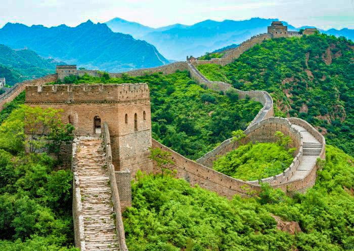
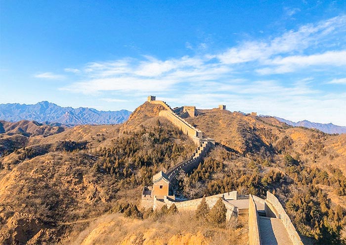
Badaling is the best-restored, most accessible Great Wall section. The wall splits into North Section (12 towers, steeper, iconic) and South Section (7 towers, gentler, less crowded) from the central Guan Cheng (Pass City) — the main entrance & starting point.
- North Section: North 1 → North 12 (North 8 = highest point, 888m, "Hero Slope")
- South Section: South 1 → South 7 (South 4 = best viewing platform)
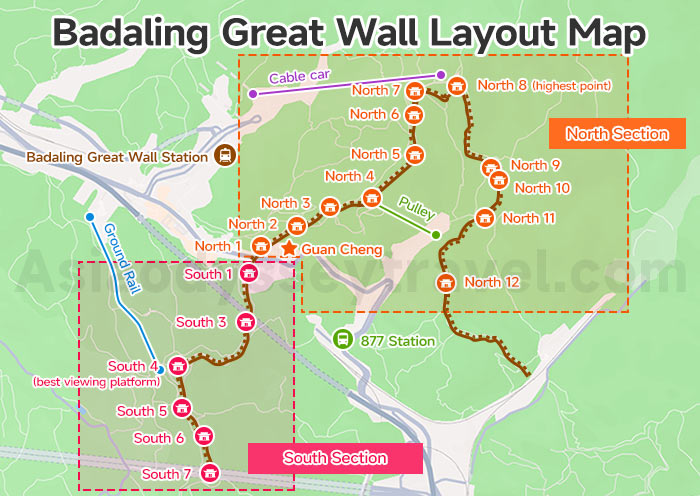
This map shows the full layout of Badaling. You can easily identify the marked areas:
- North & South sections highlighted with frames
- High-speed rail station
- Central Guan Cheng
- Ground rail in the South area
- Cable car and pulley routes in the North area
- All towers from North 1 to North 12 and South 1 to South 7
From the map, you can clear see the key spots including Guan Cheng (Main Entrance), Cable Car Stations, Pulley (Toboggan) Station, and towers in northern and southern scenic area.
Attractions Map: What to See in Badaling Great Wall
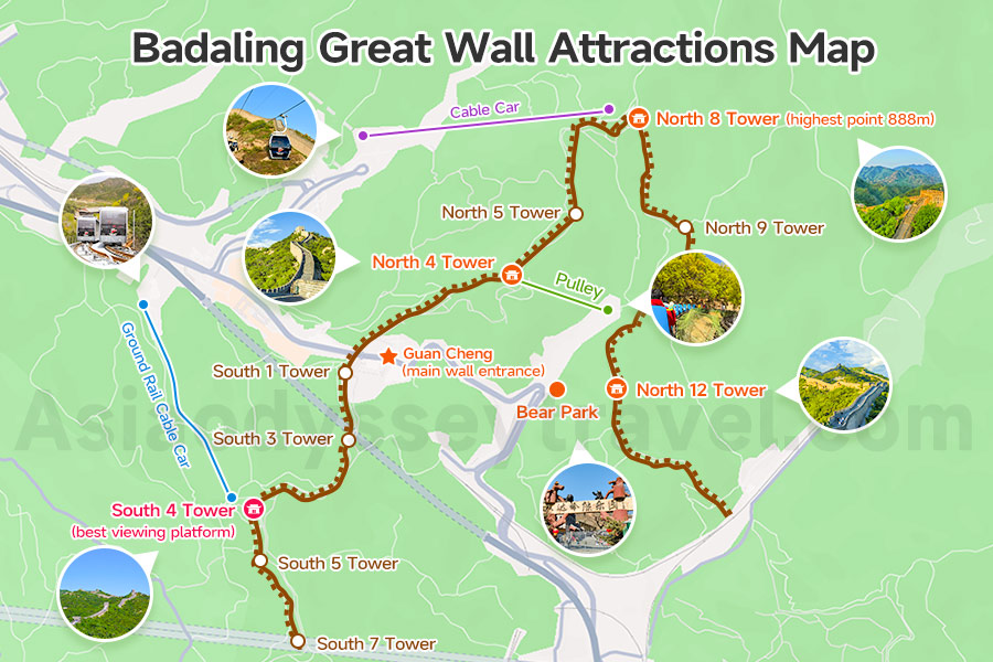
This map highlights the most popular spots with labels and corresponding photos.
From the map, you can see the key tourist spots below:
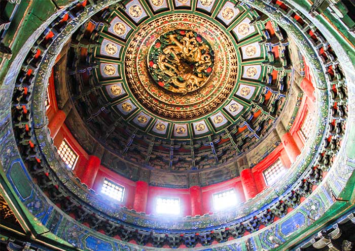
Guan Cheng (Pass City) – Central hub, main wall entrance, ticket office, info center, museum
North 4 Tower – Famous "Hero Stele" photo spot, pulley station below
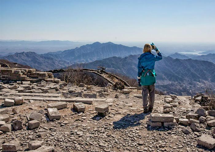
North 8 Tower (Viewing Platform) – Highest point (888m), panoramic views of winding wall, end of most hiking routes
North 12 Tower – Far end of open North Section
South 4 Tower – Best south-side viewpoint, gentle slope, cable car station
Ground Rail Cable Car (South) – Runs to South 4, stable and convenient for all visitors
Cable Car (North) – Up to North 7 Tower (fast for seniors/families)
Pulley (Toboggan) – From North 4 down to entrance (fun downhill ride)
Bear Park – Near main entrance, after hiking
Travel Map: How to Go Up and Down at Badaling Great Wall
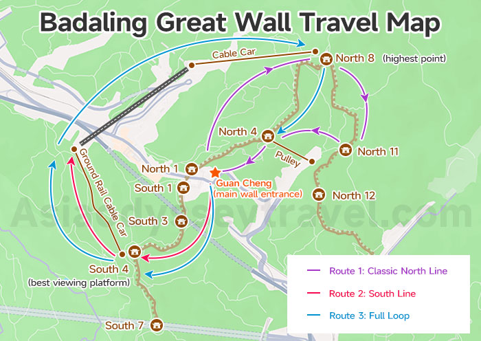
Route 1: Classic North Line (Most Popular, 2.5–3.5 hrs, Moderate)
Path: Guan Cheng → North 1 → North 4 (Hero Stele) → North 8 (Hero Slope, Highest Point) → North 11 → Take Pulley / Walk back to Guan Cheng
Best for: First-time visitors, photo seekers, moderate fitness
Map note: Follows the main crowded but well-paved path; North 8 is the must-see peak
- North line is steeper and more challenging with better panoramic views. Also more crowded
- There are 12 towers in total on the North Line. North 8 is the highest point.
- If hiking the whole way, it takes about 2.5–3 hours from North 1 to North 8.
- North 4 and North 7 have the pulley and cable car stations. Vending machines are available here for bottled water with mobile payment.
- The section from North 8 to North 9 is downhill but very steep and long — the most difficult part of the North Line.
- Exiting at North 11 leads to Bear Park, which you can visit if you have time.
6 Days Beijing Xian Highlights Tour by High Speed Train
Beijing - Xian
Route 2: South Line (Quiet, Easy, 1–1.5 hrs)
Path: Guan Cheng → South 1 → South 4 (Best View) → Down by ground rail
Best for: Families with kids, seniors, short time, avoiding crowds
Map note: Gentle slope, fewer people, great for relaxed walking & photos
- South line is easier and gentler, quieter and less crowded, also shorter with more relaxed hike
- There are 7 towers on the South Line. South 4 is the highest point and recommended as your turn-back spot.
- Hiking from South 1 to South 4 takes about 30 minutes; the ground rail cable car takes only 8 minutes.
- The path from South 3 to South 4 is relatively steep, with handrails for support.
Badaling Great Wall Half-day Night Tour (Ticket & Transfers Included)
Beijing - Badaling Great Wall - Beijing
Route 3: Full Loop (Comprehensive, 4–6 hrs, Challenging)
Path: Guan Cheng → South 1 → South 4 → Down by ground rail → Cross over to South Section → Cable Car up to North 8 → North 4 → Take Pulley / Walk back to Guan Cheng
Best for: Strong hikers, full experience
Map note: Covers all open sections; long walk, wear sturdy shoes
- The North and South sections are not connected at the far ends.You cannot walk directly from North 12 to South 7, or vice versa — you must return to Guan Cheng to switch sections.
- Recommended order for elderly visitors: North Cable Car (to North 7) → Ground Rail Cable Car (to South 4) → Hiking → Pulley Toboggan
Badaling Great Wall Vs. Other Sections of the Great Wall
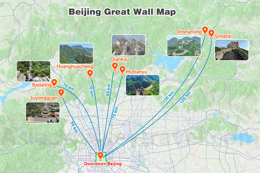
| Section | Distance from Beijing | Transport Time (One-way) | Key Highlights |
|---|---|---|---|
| Badaling | ~70 km | 1–1.5 hrs (bus/S2/high-speed rail) | Most famous, fully restored, best facilities, closest to city, most crowded, Accessible by bullet train |
| Mutianyu | ~75 km | 1.5–2 hrs (bus/car) | 90% forest cover, cable car + toboggan, less crowded, wide gentle paths, Tower 14–20 (peak view) |
| Jinshanling | ~130 km | 2.5–3 hrs (car/tour bus) | Original Ming structure, dense watchtowers, sunrise/sunset, few tourists, photo paradise |
| Simatai | ~120 km | 2.5–3 hrs (car) | Only original Ming wall open for night tours, steep & narrow, connected to Gubei Water Town |
| Jiankou | ~80 km | 2 hrs (car) | Wild & unrenovated, dramatic ridges, no facilities |
| Juyongguan | ~50 km | 1 hr (bus/car) | Circular wall, Yun Tai (ancient stone carvings), military fortress feel |
| Huanghuacheng Lakeside Great Wall | ~70 km | 1.5–2 hrs (car/bus) | Unique "Great Wall entering water" landscape, lake views, boat rides, quiet & scenic |