+852 5394 6901
 Take China Group Tours in 2026/2027 to enjoy 30% discount compared to private tour. Same Experience & Lowest Price!

Location Map of Shangri-La China: Where Is Shangri-La in China?
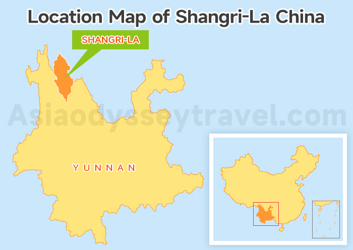
If you look at the Location Map of Shangri-La China, you'll find us tucked away in the northwestern corner of Yunnan, right where the clouds seem to touch the earth.
Specifically, we are at about 27.8° N latitude and 99.7° E longitude. We sit on the southeastern edge of the massive Tibetan Plateau, which explains why the air feels so crisp and thin.
The elevation here is no joke! The city center sits at about 3,160 meters (10,367 feet) above sea level.
It's a place of dramatic borders, neighbored by Tibet to the northwest and Sichuan to the northeast.
Because of this unique spot on the Shangri-La China Map, you get a beautiful mix of Tibetan culture and Yunnan's famous biodiversity.
Tourist Map of Shangri-La China: What to See in Shangri-La?
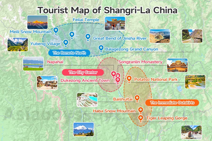
When you open a Tourist Map of Shangri-La China, you'll see that Shangri-La's attractions are a blend of "Sacred" and "Natural."
You can expect sprawling gilded monasteries, alpine lakes that look like mirrors, and some of the deepest river canyons on the planet.
Here is the breakdown by region:
The City Center
| Attractions | Coordinates | Distance from Center | Entry |
| Dukezong Ancient Town (独克宗古城) | 27.81° N, 99.71° E | 0 km | Free |
| Songzanlin Monastery (噶丹松赞林寺) | 27.82° N, 99.71° E | 5 km | 90 RMB |
| Napahai Lake (纳帕海) | 27.81° N, 99.66° E | 8 km | Free |
Right in the heart of things, you have Dukezong Ancient Town (独克宗古城), the 1,300-year-old "Moonlight City."
Just a short 20-minute drive away is the Songzanlin Monastery (噶丹松赞林寺), often called the "Little Potala Palace."
If you want a quick nature fix, Napahai Lake (纳帕海) is right at the edge of town, where yaks graze on the seasonal wetlands.
The Immediate Outskirts
| Attractions | Coordinates | Distance from Center | Entry |
| Potatso National Park (普达措国家公园) | 27.80° N, 99.91° E | 22 km | 138 RMB |
| Tiger Leaping Gorge (虎跳峡) | 27.19° N, 100.11° E | 100 km | 45 RMB |
| Baishuitai (白水台) | 27.32° N, 100.10° E | 120 km | 30 RMB |
| Haba Snow Mountain (哈巴雪山) | 27.50° N, 100.04° E | 100 km | Free |
A bit further out, Potatso National Park (普达措国家公园) offers pristine forests and Shudu Lake.
For the adventurous, the thundering waters of Tiger Leaping Gorge (虎跳峡) and the limestone terraces of Baishuitai (白水台) are essential stops.
If you're a hiker, the 5,396-meter Haba Snow Mountain (哈巴雪山) awaits.
The Remote North
| Attractions | Coordinates | Distance from Center | Entry |
| Meili Snow Mountain (梅里雪山) | 28.46° N, 98.82° E | 180 km | Free |
| Feilai Temple (飞来寺) | 28.46° N, 98.82° E | 185 km | Free |
| Yubeng Village (雨崩村) | 28.27° N, 99.42° E | 90 km | 55 RMB |
| Great Bend of Jinsha River (金沙江大湾) | 28.38° N, 98.82° E | 195 km | Free |
| Balagezong Grand Canyon (巴拉格宗) | 28.26° N, 99.27° E | 160 km | 165 RMB |
This is for the deep explorers. Meili Snow Mountain (梅里雪山) and its famous Feilai Temple (飞来寺) viewpoint are iconic.
You can also find the "hidden" Yubeng Village (雨崩村), the horseshoe-shaped Great Bend of Jinsha River (金沙江大湾), and the dramatic Balagezong Grand Canyon (巴拉格宗).
Travel Map of Shangri-La China: How Many Days to Spend in Shangri-La?
Most of my travelers find that 3 to 5 days is the sweet spot to stay in Shangri-La.
This gives you enough time to see the city highlights without rushing and leaves room for a journey into the northern mountains.
I recommend spending 1-2 days in the city center, another day or two in the immediate outskirts, and at least 2 days if you plan to head to the remote north.
#1 Travel Map of Shangri-La China: A Dukezong Ancient Town Map
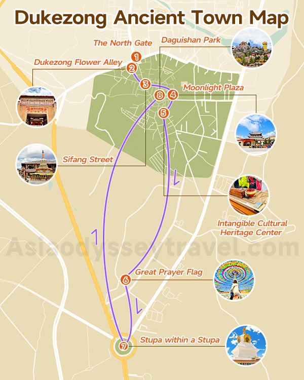
You don't need a car for this part of your Travel Map of Shangri-La China. The best way to experience the old town is on FOOT! There are 3 gates open: the North, East and South Gate.
The North Gate → Dukezong Flower Alley → Sifang Street → Moonlight Plaza → Intangible Cultural Heritage Center → Great Prayer Flag → the "Stupa within a Stupa" → Daguishan Park.
Start at the North Gate archway, then wander through the Dukezong Flower Alley (独克宗花巷) toward Sifang Street (四方街).
Then, make your way to Moonlight Plaza (月光广场), visit the Intangible Cultural Heritage Center (古城非遗体验中心), and see the Great Prayer Flag (大经幡).
Don't miss the "Stupa within a Stupa" (和谐塔中塔) before ending your climb at Daguishan Park (大龟山公园) to spin the world's largest prayer wheel.
Half a day to a full day is enough for this slow-paced cultural immersion!
#2 Travel Map of Shangri-La China: A 4-Day Deep Dive in Shangri-La
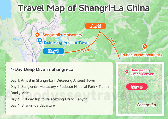
If you want to stay focused on this region, this Travel Map of Shangri-La China itinerary connects the dots seamlessly.
We base in Shangri-La city, covering a total distance of about 240 kilometers (150 miles) over the 4 days.
| Day | Where to Go | What to See & Do |
| 1 | Arrival in Shangri-La | Airport/Train pick-up, Hotel check-in, Evening stroll in Dukezong Ancient Town |
| 2 | Shangri-La | Morning at Songzanlin Monastery, Afternoon at Pudacuo National Park, Evening Tibetan Family Visit |
| 3 | Shangri-La | Full day trip to Balagezong Grand Canyon, exploring Bala Village and the Echo Wall |
| 4 | Shangri-La departure | Morning souvenir shopping, Final market visit, and Transfer to airport/station |

 4 Days
 2 Places
#3 Travel Map of Shangri-La China: A Classic 8-Day Yunnan Discovery (Kunming - Dali - Shangri-La - Lijiang)
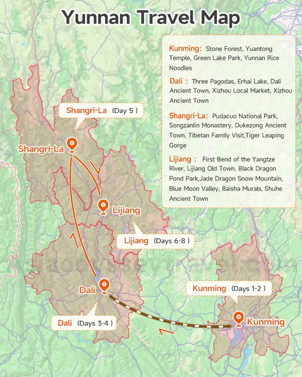
For the ultimate discovery trip, use this Travel Map of Shangri-La China to see how we bridge the high plateau with the rest of Yunnan.
This route takes you on a 950-kilometer (590-mile) journey through Yunnan's most iconic stops.
Starting in the capital of Kunming, heading to Shangri-La, and ending in Lijiang, we use a mix of high-speed rail and private drives to connect Dali along the way.
| Day | Where to Go | What to See & Do |
| 1 | Kunming Arrival | Meet your driver and settle into your hotel. |
| 2 | Kunming | Stone Forest, Yuantong Temple, Green Lake Park, Yunnan Rice Noodles |
| 3 | Kunming to Dali | High Speed Train, Three Pagodas, Erhai Lake, Dali Ancient Town |
| 4 | Dali to Shangri-La | Car ride, Xizhou Local Market, Xizhou Ancient Town, Zhoucheng Tie-dye |
| 5 | Shangri-La | Pudacuo National Park, Songzanlin Monastery, Dukezong Ancient Town, Tibetan Family Visit |
| 6 | Shangri-La to Lijiang | Car ride, Tiger Leaping Gorge, First Bend of the Yangtze River, Lijiang Old Town, Black Dragon Pond Park |
| 7 | Lijiang | Jade Dragon Snow Mountain, Blue Moon Valley, Baisha Murals, Shuhe Ancient Town (Optional) |
| 8 | Lijiang Departure | Final breakfast and transfer to the airport or train station. |
8 Days Classic Yunnan Group Tour: Kunming Dali Shangri-La Lijiang
Kunming - Dali - Shangri-La - Lijiang
This route is designed for a budget-friendly group (max 16 people) with an English-speaking guide, an experienced driver, and 7 nights in cozy 4-star hotels.
Airport & Railway Station Map of Shangri-La China: How to Get to Shangri-La?
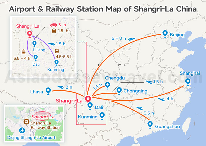
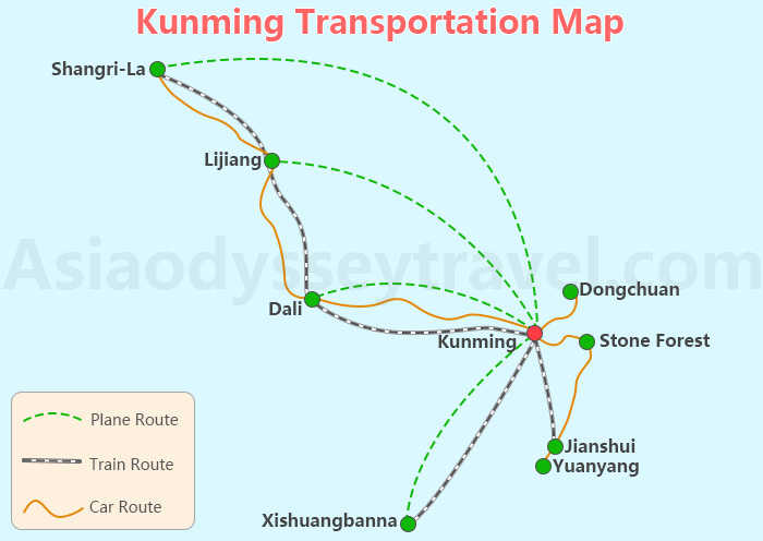
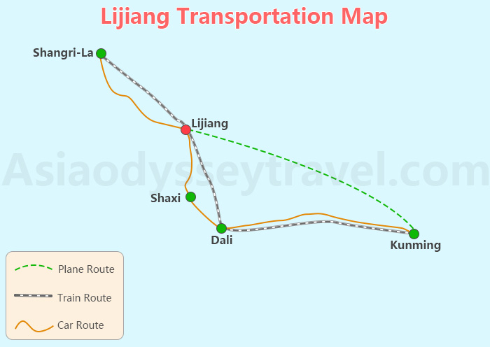
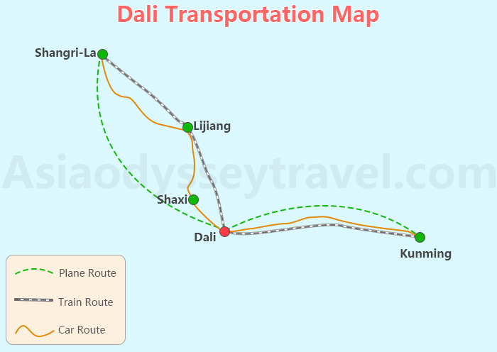
Getting to Shangri-La used to be a long trek, but not anymore! You can now reach the by air, high-speed train, or a scenic car ride.
On our Airport & Railway Station Map of Shangri-La China, you'll see the Shangri-La Railway Station and Diqing Shangri-La Airport (DIG) have changed the game!
The Shangri-La Railway Station (27°48'48.0"N, 99°41'19.0"E) is located about 15 minutes from the Shangri-La Old Town, and the Diqing Shangri-La Airport (DIG: 27°47′36″N, 99°40′38.4″E) is close too, about 15 - 20 minutes.
Here is how long it takes to reach us from popular hubs across China:
| From | To | Transport Mode | Estimated Travel Time |
| Kunming | Shangri-La Railway Station / DIG | Train / Flight | 4.5 – 5.5 Hours / 1.5 Hours |
| Dali | Shangri-La Railway Station / Shangri-La | Train / Car | 3.5 – 4 Hours (Train) / 4 Hours (Car) |
| Lijiang | Shangri-La Railway Station / Shangri-La | Train / Car | 1.5 Hours (Train) / 3 Hours (Car) |
| Chengdu | Diqing Shangri-La Airport | Flight | 1.5 Hours |
| Chongqing | Diqing Shangri-La Airport | Flight | 1.5 Hours |
| Beijing | Diqing Shangri-La Airport | Flight | 5 – 8 Hours |
| Shanghai | Diqing Shangri-La Airport | Flight | 4 Hours |
| Guangzhou | Diqing Shangri-La Airport | Flight | 3.5 Hours |
| Lhasa | Diqing Shangri-La Airport | Flight | 2 Hours |

14 Days Yunnan Tibet Discovery Tour with Yamdrok Lake & EBC
Kunming - Lijiang - Shangri-La - Lhasa - Gyantse - Shigatse - Mt. Everest - Lhasa
Transportation Map of Shangri-La China: How to Get around Shangri-La China?
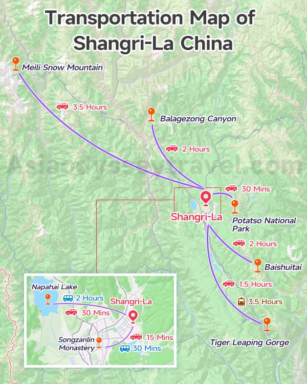
Once you've touched down or hopped off the train, navigating the city is straightforward.
Within the ancient town, your own two feet are the best way to explore the narrow alleys.
For everything else, our Transportation Map of Shangri-La China relies on a mix of buses and private charters for those longer mountain roads.
| From City Center To... | Transport Mode | Distance | Estimated Travel Time |
| Songzanlin Monastery | Local Bus #3 / Car | 5 km | 30 Minutes / 15 Minutes |
| Napahai Lake | Local Bus #3 / Car | 11 km | 2 Hours / 30 Minutes |
| Potatso National Park | Car | 25 km | 30 Minutes |
| Tiger Leaping Gorge | Car / Train | 100 km / 240 km | 1.5 Hours / 3.5 Hours |
| Baishuitai | Car | 100 km | 2 Hours (Winding roads) |
| Meili Snow Mountain | Car | 180 km | 3.5 Hours |
| Balagezong Canyon | Car | 90 km | 2 Hours |
7 Days Yunnan Hiking Tour: Lijiang Shangri-La & Tiger Leaping Gorge Hike
Lijiang - Tiger Leaping Gorge - Shangri-La
Explore the Place Nearest to Heaven with our Shangri-La China Map
At Asia Odyssey Travel, we don't just show you the map; we take you inside the stories!
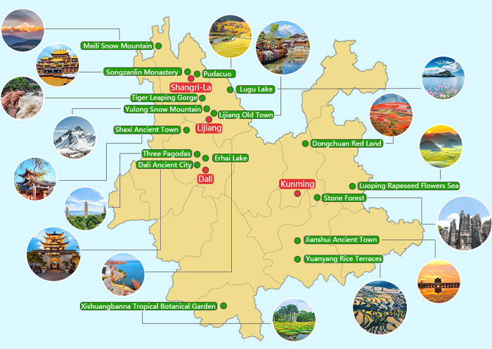
We specialize in deep dives through Shangri-La and the rest of Yunnan's "Greatest Hits." Whether you want to see the ancient architecture of Jianshui or the tropical vibes of Xishuangbanna, we know how to piece together the perfect combo.
We know the best ways to combine destinations—like Kunming and Lijiang or a full Dali to Shangri-La loop—ensuring you spend less time in transit and more time soaking in the culture.
Let us help you find your own "Shambhala."







 Data in submission...