Where Is Daegu in South Korea: Daegu Location Map
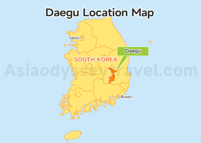
First, where is Daegu on a map? It sits at 35.87° N latitude and 128.60° E longitude, nestled in a giant basin in the southeast part of the Korean peninsula.
The Nakdong River flows right along its western border, carving a scenic edge for the city.
It's the perfect middle ground between the Seoul and Busan. You'll find it exactly 310 km from Seoul (1h 40m by KTX) and just 131 km from Busan (40m by KTX).
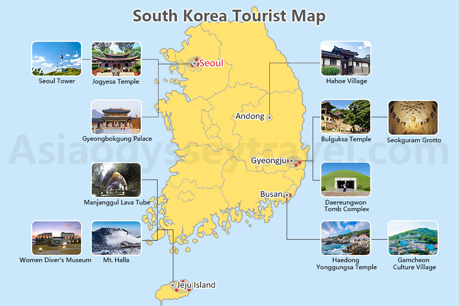
Map of South Korea | South Korea Travel Map (2026)
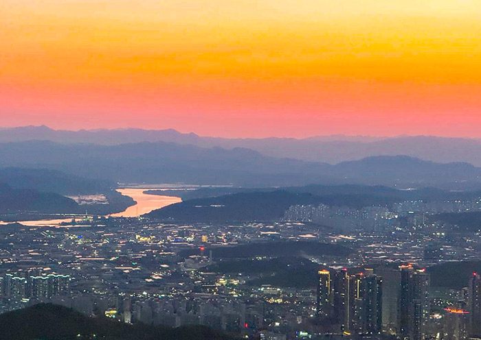
Locals call the city "Daefrica" (Daegu + Africa). The surrounding mountains trap the heat, making it the hottest city in South Korea with average highs often hitting 33°C (91°F).
Daegu City Map: How Is South Korea's 4th Largest City Laid Out?
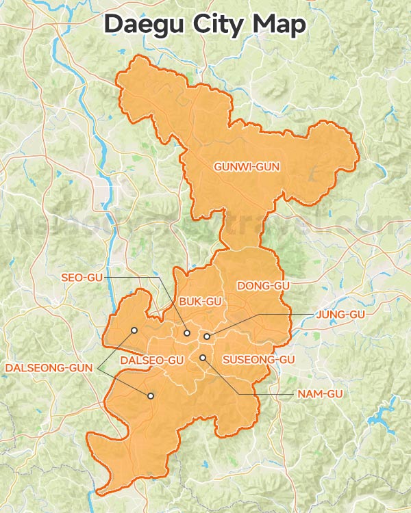
Now we move to the Daegu City Map to see the layout of the city itself. It is organized into 8 districts that fan out from the historic center, each offering a different flavor of local life.
From the bustling markets of the center Jung-gu to the quiet mountain peaks in the north, here is the breakdown of how the city is split:
| District | Vibe | Signature Attraction |
|---|---|---|
| Jung-gu | The heart of it all. Historical and commercial center. | Yangnyeongsi Medicine Market |
| Nam-gu | Nature meets the city. Great night views. | Apsan Observatory |
| Suseong-gu | The "Gangnam" of Daegu. Wealthy and relaxed. | Suseongmot Lake |
| Dalseo-gu | Family fun and big parks. | E-World & 83 Tower |
| Dong-gu | The gateway. Home to the airport and KTX. | Palgongsan Mountain |
| Seo-gu | Raw and local. Great for K-pop fans. | V Mural Street |
| Buk-gu | Modern and creative. | The ARC / Opera House |
| Gunwi-gun | The quiet outskirts. Perfect for "slow" travel. | Thinking Garden (Sayuwon) |
| Dalseong-gun | It's where peaceful nature meets living history. | Biseulsan Mountain, Nakdong River |
Most travelers spend 80% of their time in Jung-gu and Nam-gu.
If you want to escape the crowds, head to Gunwi-gun—it has been added to Daegu since 2023 and feels like a secret countryside retreat.
Daegu Tourist Map: What Is Daegu Known for?
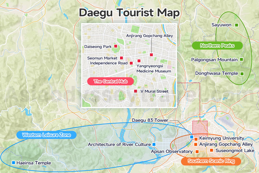
Daegu is a city of layers!
You might know it for the massive stone Buddha at Palgongsan Mountain, the bustling energy of Seomun Market, or its legendary vibrant cafe culture.
Whether you are chasing ancient history or modern K-pop landmarks, there is a perfect spot for you on the Daegu Tourist Map.
To make your planning easy, I've separated the best spots into 5 geographic zones.
The Central Hub
This is the heart of the city and the easiest area to explore! Most of these spots are just a short walk or a couple of subway stops away from each other.
| Attractions | Korean Name | District | Access Point |
|---|---|---|---|
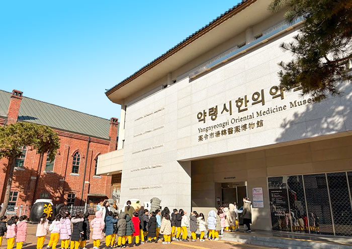
| Yangnyeongsi Medicine Museum | 대구약령시 한의약박물관 | Jung-gu | Banwoldang Stn. Exit 14 |
| Seomun Market | 서문시장 | Jung-gu | Seomun Market Stn. Exit 2 |
| Independence Road (Daegu Heritage Trail) | 3.1만세운동길 | Jung-gu | Cheongna Hill Stn. Exit 9 |
| Dongseong-ro | 대구 동성로거리 | Jung-gu | Jungangno Stn. Exit 2 |
| V Mural Street | 뷔 벽화거리 | Seo-gu | Bus to Daesung Elementary |
| Dalseong Park | 달성공원 | Jung-gu | Dalseong Park Stn. Exit 3 |
I love starting a morning at Yangnyeongsi Museum of Oriental Medicine because the smell of herbal medicine and ginseng is so relaxing.
Just a few blocks away, Seomun Market is a total sensory overload—it's the best place to grab some "flat dumplings" and get lost in the stalls.
If you want a bit of history, walk the 90 steps at Independence Movement Road where students once hid during the 1919 protests.
For a modern twist, head to Dongseong-ro, the city's pulse where you can dive into the vibrant cafe culture.
BTS fans, don't miss the V Mural Street and his childhood playground at Dalseong Park—it's a true pilgrimage site!
Southern Scenic Ring
This zone is where the city meets the mountains. It is the most photogenic part of Daegu and perfect for late afternoon strolls.
| Attractions | Korean Name | District | Access Point |
|---|---|---|---|
| Apsan Observatory | 앞산전망대 | Nam-gu | Apsan Cable Car |
| Anjirang Gopchang Alley | 안지랑 곱창골목 | Nam-gu | Anjirang Stn. Exit 3 |
| Suseongmot Lake | 수성못 | Suseong-gu | Suseongmot Stn. Exit 1 |
| Keimyung University (Daemyung Campus) | 계명대학교 | Nam-gu | Daemyung Campus |
| Suga Mural Street | 슈가 벽화거리 | Nam-gu | Myeongdeok Stn. Exit 1 |
You have to take the cable car up to Apsan Observatory for the sunset. It was a filming site for What's Wrong with Secretary Kim? and has the absolute best night view of the city basin.
Afterward, head down to Anjirang Gopchang Alley to try some grilled delicacies—it's one of the "10 Flavors of Daegu" and the vibe is incredibly local.
If you prefer a romantic walk, Suseongmot Lake has a beautiful musical fountain show at night.
Don't forget to check out the ivy-covered buildings at Keimyung University (seen in dozens of K-dramas) or the creative Suga Mural Street near Myeongdeok Station.
Western Leisure Zone & Western Outskirts
These two groups sit on the western side of the Daegu Tourist Map, offering a mix of high-energy fun and quiet tradition.
| Geographic Zone | Attractions | Korean Name | District | Access Point |
|---|---|---|---|---|
| Western Leisure | 83 Tower & E-World | 이월드 | Dalseo-gu | Duryu Stn. Exit 15 |
| Architecture of River Culture | 디아크 | Dalseong-gun | Bus/Taxi from Daesil Stn. | |
| Western Outskirts | Haeinsa Temple | 해인사 | Hapcheon-gun | Intercity Bus (Seobu Term.) |
For a fun afternoon, 83 Tower & E-World is the place to be. It's Daegu's iconic theme park with massive flower festivals and great rides.
If you like architecture, The ARC looks like a giant silver whale on the river and is stunning at sunset.
The Western Outskirts are home to the legendary Haeinsa Temple.
It is a UNESCO World Heritage site where you can see the 800-year-old Janggyeong Panjeon woodblocks. It's a peaceful day trip that feels like stepping back in time.
Northern Peaks
This is the highest point of the city! The Palgongsan Mountain reaches 1,192 meters. It's the best place to find fresh air and escape the "Daefrica" heat.
| Attractions | Korean Name | District | Access Point |
|---|---|---|---|
| Palgongsan Mountain | 팔공산 | Dong-gu | Express Bus 1 |
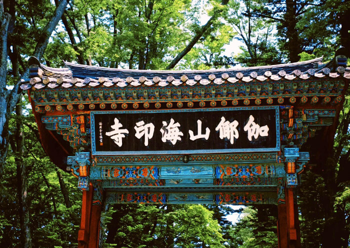
| Donghwasa Temple | 동화사 | Dong-gu | Express Bus 1 |
| Thinking Garden (Sayuwon) | 사유원 | Gunwi-gun | Shuttle / Private Car |
Palgongsan Mountain is a local favorite for hiking, but you can just take the cable car up for the views. Make sure to visit Donghwasa Temple to see the massive stone Buddha that stands over 17 meters tall.
If you want something more meditative, the Thinking Garden (Sayuwon) in Gunwi is a breathtaking architectural park that also appeared in Queen of Tears.
Simply copy the Korean name (Hangeul) from the tables above and paste it into Naver Map or KakaoMap. It is the only way to get 100% accurate walking and subway directions in South Korea!
If you only have one day, stick to the Center (Zone 1) and South (Zone 2). You can grab a street food lunch at Seomun Market and end your night with the city lights at Apsan Observatory without wasting time in transit.
Eworld Daegu Map: How to Ride the Theme Park?
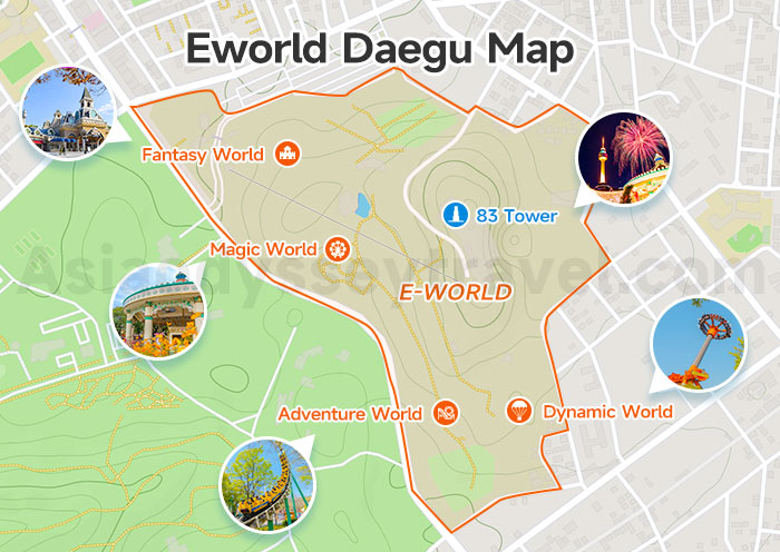
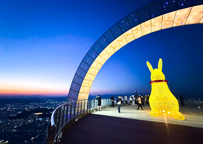
If you want to find the heart of fun in Daegu, look no further than the E-World Daegu Map. This massive park is built around the iconic 83 Tower and is split into 4 themed worlds that climb up the hillside.
It is designed to take you from family-friendly "Magic World" at the bottom to heart-pumping "Dynamic World" at the top.
| Zone | Must-Ride | Best For |
|---|---|---|
| 83 Tower | Observatory, Sky Lounge, Ice Rink | Panoramic views and romantic dinners |
| Fantasy World (The Entrance) | Ghost House, Snow World, Giant Magic Book | Fairy-tale photos and the main entrance |
| Magic World | Magic Train, Flying Elephant, Merry Go Round, Flume Ride | Families with younger children |
| Adventure World | Boomerang Coaster, Camelback Coaster, Top Spin, Zoozoo Farm | Classic thrills and animal lovers |
| Dynamic World | Mega Swing 360, Sky Drop, Tambourine, Baloon Race, Hurricane Coaster | Hardcore adrenaline seekers |
Don't exhaust yourself walking uphill!
I always advise travelers to take the Sky Way (Cable Car) from the entrance directly up to the 83 Tower first. You can enjoy the view on the way up, and then explore the park by walking downhill through the themed zones.
If you visit during the Spring Cherry Blossom Festival (from late March to early April), you are in for a treat.
The best place to view the blossoms is the long road leading from the entrance up to the 83 Tower. It becomes a literal pink tunnel of flowers and is famous as the best photo spot in Daegu.
Let's Connect the Dots to Lines: Your Travel Plan on Daegu Map
A map is just a collection of points until you add a path. To help you visualize your trip, I've centered on two Travel Maps of Daegu.
These maps turn individual attractions into a seamless journey, showing you exactly how to move through the city.
Below are 2 ways to use this travel map: one for a high-energy day trip and another for a grand 10-day loop around South Korea.
#1 Travel Map of Daegu: A Day Trip in Daegu
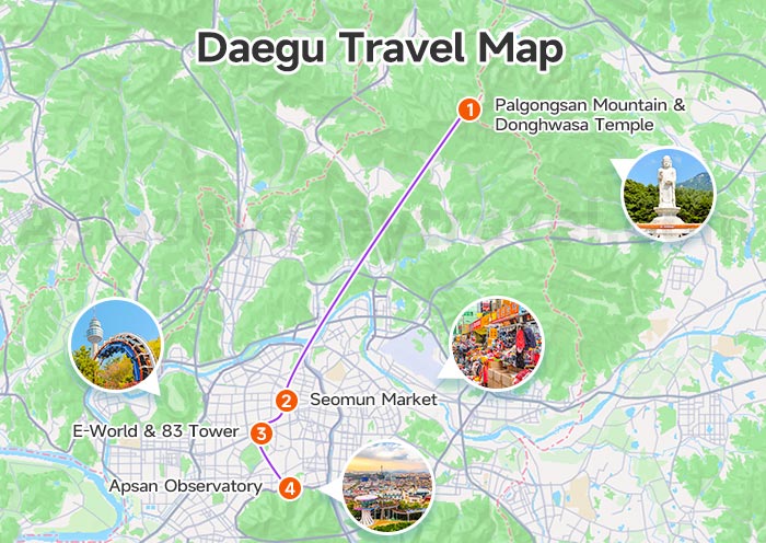
As you can see on this Map of Daegu, this plan creates a straight line from the North to the South of the city.
It is the most efficient way to see Daegu's icons without backtracking, making it the best route for travelers with only one day in the city.
| Time | Where to Go | What to Do |
|---|---|---|
| 9:00 AM | Palgongsan Mountain & Donghwasa Temple | Start at Palgongsan Mountain for the morning mist. |
| 12:00 PM | Seomun Market | Lunch break! Try the flat dumplings and spicy tteokbokki. |
| 3:00 PM | E-World & 83 Tower | Catch the views and maybe a few thrill rides. |
| 6:00 PM | Apsan Observatory | Sunset and night views to end the day. |
- Donghwasa to Seomun Market: About 45–60 mins via Express Bus 1 or 30 mins by taxi.
- Seomun Market to E-World: About 15 mins via Subway Line 2 (Duryu Station) or 10 mins by taxi.
- E-World to Apsan Observatory: About 20 mins by taxi to the cable car station.
#2 Travel Map of Daegu: 10 Days South Korea Loop
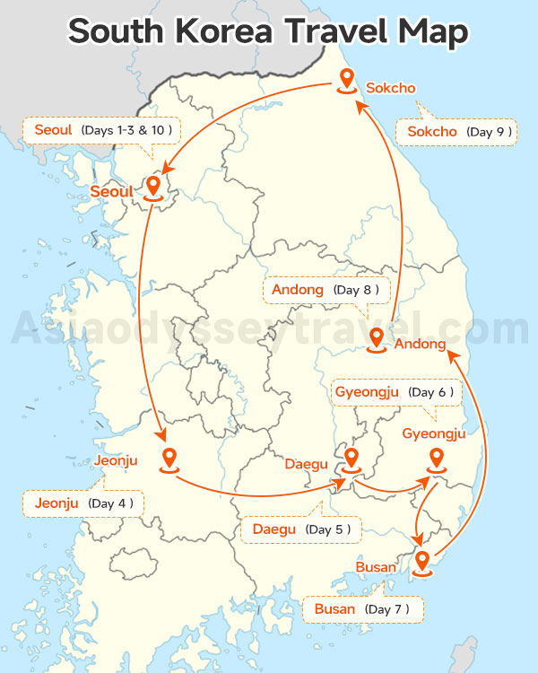
If you want the full experience in South Korea, Daegu is a vital stop on this 10 days "Grand Loop."
This route on our Travel Map of Daegu is best for first-timers who want to see everything from the DMZ to the southern coast.
| Day | Where to Go | What to Do |
|---|---|---|
| 1 | Seoul Arrival | Pick-up service and hotel check-in. |
| 2 | Seoul City Tour | Gyeongbokgung Palace and Bukchon Hanok Village. |
| 3 | Seoul - DMZ - Seoul | Visit the 3rd Infiltration Tunnel and Dora Observatory. |
| 4 | Seoul to Jeonju | KTX to the Hanok Village and Tabsa Temple. |
| 5 | Jeonju - Daegu | Explore Haeinsa Temple and the Seongbo Museum. |
| 6 | Gyeongju | Bulguksa Temple and the Daereungwon Royal Tombs. |
| 7 | Gyeongju - Busan | Gamcheon Culture Village and the Sky Capsule. |
| 8 | Busan - Andong | Visit the UNESCO Hahoe Folk Village. |
| 9 | Sokcho - Seoul | Mt. Seorak and the Gwongeumseong Cable Car. |
| 10 | Seoul Departure | Final check-out and airport see-off. |

10 Day South Korea Round Tour: Classic Culture Heritage and Nature Wonders
Seoul - Jeonju - Daegu - Gyeongju - Busan - Andong - Sokcho - Seoul
For this 10-day South Korea journey, we include all airport transfers, private vehicles for sightseeing, and your KTX bullet train tickets from Seoul to Jeonju. You just bring your camera!
Daegu Subway (Metro) Map: How to Get Around the Cafe Capital of South Korea?
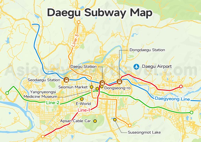
Navigating Daegu is a breeze by subway, the city's most popular transport for dodging traffic. You'll mostly use Banwoldang (the central hub) and Dongdaegu (KTX/Bus connection).
Based on current Daegu Subway Map, there are 4 lines serving the area:
| Attractions & Transport Hubs | Subway Line | Stops |
|---|---|---|
| Donghwasa Temple & Palgongsan Mountain | Line 1 | Ayanggyo (then Bus Palgong 1 or Express 1) |
| Seomun Market | Line 3 | Seomun Market |
| E-World & 83 Tower | Line 2 | Duryu (Exit 15) |
| Apsan Observatory & Cable Car | Line 1 | Anjirang (then Bus 410-1 or Taxi) |
| Dongseong-ro | Line 1 & 2 | Jungangno / Banwoldang |
| Haeinsa Temple (via Seobu Terminal) | Line 1 | Seongdangmot (Seobu Bus Terminal) |
| Suseongmot Lake | Line 3 | Suseongmot |
| Yangnyeongsi Medicine Museum | Line 1 & 2 | Banwoldang / Jungangno |
| Dongdaegu Station (KTX / Shinsegae) | Line 1 | Dongdaegu |
| Daegu Station | Line 1 | Daegu |
| Seodaegu Station (KTX / Regional) | Daegyeong Line | Seodaegu |
| Daegu Airport | Line 1 | Ayanggyo (then Bus Palgong 1 or Express 1) |
Note: The latest Daegu metro data comes from Hanchao Map.
- Single-Journey: Purchase a "token" at automated machines. You must tap to enter and insert the token to exit. Return it at the destination to get your 500 KRW deposit back.
- Rechargeable Card: Buy a T-money card at any convenience store (GS25/CU). It's faster, handles transfers, and machines now accept international credit cards.
Daegu Train Map: How to Get Out of the City?
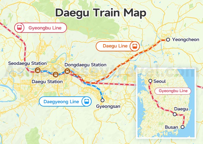
Daegu's location makes it the geographical heart of South Korea's rail network. This Daegu Train Map allows you to reach major South Korean destination in under 2 hours.
Dongdaegu Station is the main hub for high-speed travel, while Daegu Station handles the bulk of regional traffic. Seodaegu Station is the western gateway, best for travelers staying in the western part of the city.
To navigate your way out of the city, there are 4 rail lines that you should know.
| Rail Lines | Stations in Daegu | Connect to... |
|---|---|---|
| Gyeongbu Line (Seoul–Busan) | Dongdaegu, Seodaegu | Seoul, Busan, Daejeon, Gyeongju (Singyeongju) |
| Daegu Line (Dongdaegu–Yeongcheon) | Dongdaegu | Yeongcheon, Pohang, Ulsan (Taehwagang) |
| Daegyeong Line (Daegu–Gyeongsan) | Dongdaegu, Daegu, Seodaegu | Gumi, Gyeongsan, Waegwan, Sagok |
For the fastest journey to Seoul, take the Gyeongbu KTX/SRT line from Dongdaegu Station (approx. 1h 40m). To reach Busan, the same line from Dongdaegu gets you there in just 35–45 minutes.
If you arrive early or have a 1-hour wait for your train, you are in luck. The Shinsegae Department Store is directly attached to Dongdaegu Station.
Don't get confused! Make sure you do not confuse Dongdaegu Station (East Daegu) with the smaller Daegu Station nearby!
- Dongdaegu: The massive hub for KTX, SRT, and the Express Bus Terminal.
- Daegu Station: Located in the city center, primarily serving conventional ITX and Mugunghwa trains.
Always double-check your ticket for the "Dong" (East) prefix!
Daegu to Seoul Map: How Long Does the KTX/SRT Take?
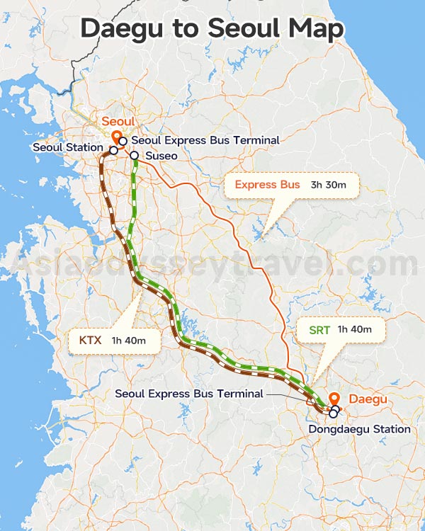
This Daegu to Seoul Map visualizes the high-speed KTX and SRT path, tracing the spine of the peninsula from the Daegu basin up to the capital.
On average, the high-speed journey takes 1h 40m. If you take a bus, expect 3.5 hours.
| Mode | Departure Hubs | Arrival Hubs | Travel Time | Distance | Price (Economy / First) | Frequency |
|---|---|---|---|---|---|---|
| KTX | Dongdaegu | Seoul Station | 1h 40m | 233 km | ₩43,500 ($29) / ₩60,900 ($41) | Every 15-30 min |
| SRT | Dongdaegu | Suseo (Gangnam) | 1h 40m | 233 km | ₩37,400 ($25) / ₩54,100 ($36) | Every 30-40 min |
| Express Bus | Dongdaegu Station Transfer Center | Seoul Express Bus Terminal | 3h 30m | 272 km | ₩20,000 ($14) / ₩32,000 ($22) | Every 30 min |
Seoul to Daegu: Distance, Bullet Train & Bus Guide 2026
Tickets open 31 days in advance. Always book at least 1 week ahead for weekdays and 2 weeks for weekends, as this is the busiest rail corridor in Korea!
Dongdaegu is the high-speed hub. If you accidentally go to the smaller Daegu Station nearby, you will only find slower trains (Mugunghwa) which take nearly 4 hours to reach Seoul!
Daegu to Busan Map: How to Reach the Coast from the Basin?
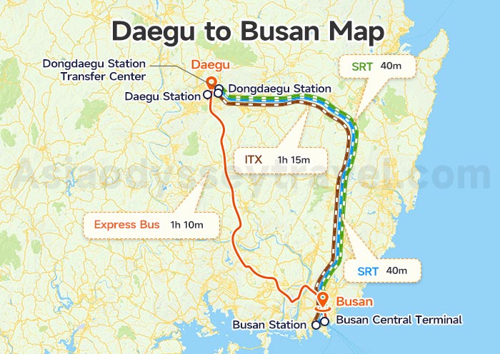
This Daegu to Busan Map shows the path from the inland valley of Daegu to the southeastern coast. The KTX and SRT ride takes approximately 40 minutes.
| Mode | Departure Hubs | Arrival Hubs | Travel Time | Distance | Price (Economy / First) | Frequency |
|---|---|---|---|---|---|---|
| KTX | Dongdaegu | Busan Station | 40m | 90 km | ₩43,500 ($29) / ₩60,900 ($41) | Every 15-20 min |
| SRT | Dongdaegu | Busan Station | 40m | 90 km | ₩15,600 ($10) / ₩22,600 ($15) | Every 30-40 min |
| ITX | Daegu / Dongdaegu | Busan Station | 1h 15m | 90 km | ₩12,100 ($8) / - | Every 1-2 hours |
| Express Bus | Dongdaegu Station Transfer Center | Busan Central Terminal | 1h 10m | 105 km | ₩7,000 ($5) / ₩11,000 ($8) | Every 20-30 min |
The regional ITX train is a great "backup plan" if KTX tickets are sold out. These trains have standing-room tickets available at the last minute which you can buy at station kiosks.
When heading south, book a window seat on the left side of the train. As you pull into Busan, you get your first glimpse of the harbor and the sea.
Download Your Daegu Map (English Version): Hand-made by Asia Odyssey Travel Experts
Our English-friendly Daegu maps are hand-made to help you get around like a local.
At Asia Odyssey Travel, we have 15 years of experience planning tours across Asia. We already have local offices in China, Japan, and SE, and our South Korea office is opening very soon!
We offer over 10 different tour packages (from 4 to 10 days) that cover all the best spots.
Beyond Daegu, we can take you to the famous sights of Seoul and Busan, or show you "hidden gems" in Jeonju, Suwon, Sokcho, Andong, and Gyeongju.
✔ English-Speaking Driver-guides: No language barrier; our driver-guides speak English and know the best local spots.
✔ Spacious Private Vans: Skip the crowds with our fleet, including 8-seater Starias and larger 11-to-16-seater vehicles.
✔ Easy Logistics: Our tour cover your KTX train or flight tickets, so you can just sit back and enjoy the view.
 Maps: Yongpyong Ski Resort Map")

")


")

")
")