Sokcho Location Map: Where is Sokcho Located on South Korea Map?
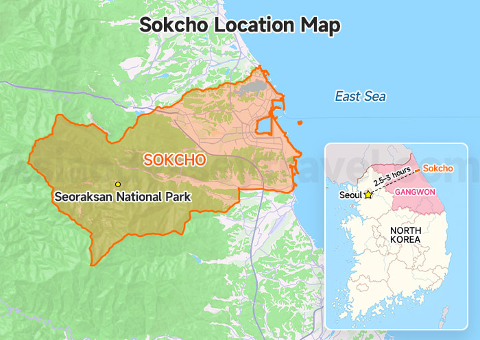
The Sokcho Location Map shows where Sokcho is located in South Korea. Sokcho (38.2070° N, 128.5918° E) sits on Korea's northeast coast in Gangwon Province.
It is not only the main gateway city to Seoraksan National Park, but also a relaxing coastal city loved by slow travelers, beach lovers, and mountain hikers.
Sokcho faces the East Sea on one side and the mountains on the other, giving the city a unique mix of ocean views and dramatic nature scenery.
From Seoul, Sokcho is about 2.5–3 hours away by express bus or car.
10 Gangwon-do (South Korea) Maps: Yongpyong Ski Resort Map
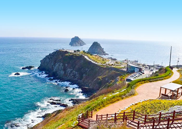
Sokcho Tourist Attractions Map: Top Places to Visit in Downtown Sokcho
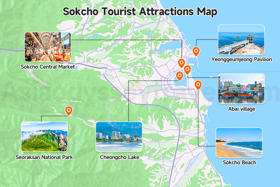
Although Sokcho is not a very large city, its main attractions are nicely spread between the coast, downtown area, and mountain side.
Most travelers spend 1–2 days slowly exploring beaches, seafood markets, cafes, and Seoraksan.
The Sokcho Tourist Attractions Map shows the city's most popular sightseeing areas and how close they are to each other.
Main attractions on the map include:
| Attractions | What it like |
|---|---|
| Sokcho Beach | the city's most famous beach |
| Sokcho Central Market | best place for local seafood and street food |
| Abai Village | a small village known for its North Korean refugee history |
| Yeonggeumjeong Pavilion | popular sunrise and coastal photo spot |
| Cheongcho Lake | a relaxing lake area with walking paths and cafes |
| Seoraksan National Park | mountain area famous for its autumn leaves and snow |
From the map, you can easily see that Sokcho is very easy to travel around. The beach area, market area, and lake area are all quite close together, while Seoraksan sits slightly west of downtown.

10 Day South Korea Round Tour: Classic Culture Heritage and Nature Wonders
Seoul - Jeonju - Daegu - Gyeongju - Busan - Andong - Sokcho - Seoul
Seoraksan National Park Map: Best Areas & Hiking Routes for First-Timers
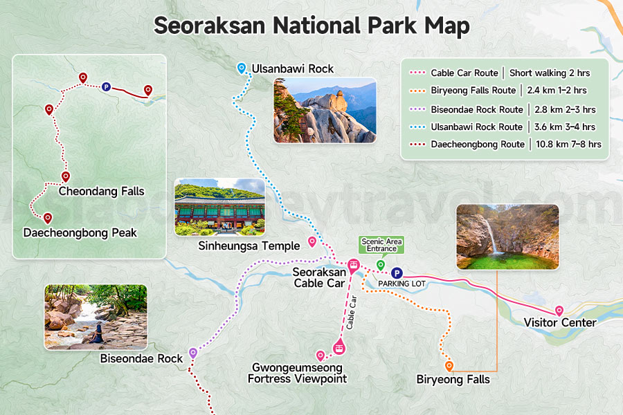
For first-time visitors, the Seoraksan National Park Map helps you quickly understand which parts of Seoraksan are easy sightseeing areas and which parts are more serious hiking zones.
The map mainly shows 4 hiking routes and 1 cable car sightseeing route inside Seoraksan National Park.
-
Cable Car Route: Visitor Center → Sinheungsa Temple → Seoraksan Cable Car → Gwongeumseong Fortress Viewpoint
-
Biryeong Falls Route: Visitor Center → Sinheungsa Temple → Biryeong Falls
-
Biseondae Rock Route: Visitor Center → Sinheungsa Temple → Biseondae Rock
-
Ulsanbawi Rock Route: Visitor Center → Sinheungsa Temple → Ulsanbawi Rock
-
Daecheongbong Route: Visitor Center → Sinheungsa Temple → Biseondae Rock → Cheondang Falls → Daecheongbong Peak
| Route | Distance | Duration | Highlights | Difficulty |
|---|---|---|---|---|
| Cable Car Route | Short walking | 2 hrs | Cable car views & autumn colors | ★ |
| Biryeong Falls Route | 2.4 km one way | 1–2 hrs | Waterfalls & forest trails | ★★ |
| Biseondae Rock Route | 2.8 km one way | 2–3 hrs | Rocky valleys & streams | ★★★ |
| Ulsanbawi Rock Route | 3.6 km one way | 3–4 hrs | Giant rock peaks & panoramic views | ★★★★ |
| Daecheongbong Route | 10.8 km one way | 7–8 hrs | Highest peak in Seoraksan | ★★★★★ |
- The park is free to enter, while the cable car fare is 15,000 KRW round trip.
- Sinheungsa Temple is a must-see point.
- Daecheongbong is the highest point of the park, and the route leads to Osaek entrance on the southern side of the park.
Sokcho to Seoraksan Bus Map: How to Get to Seoraksan from Sokcho
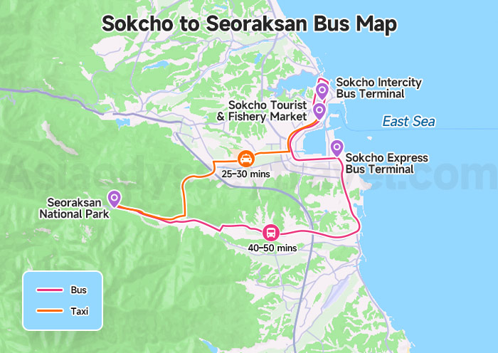
For most travelers visiting Seoraksan National Park, local buses 7 and 7-1 are the easiest and cheapest transportation options from downtown Sokcho.
The bus route connects Sokcho's main tourist areas directly with the Seoraksan entrance area, making it very convenient even without a rental car.
You can get on the bus from Sokcho Express Bus Terminal and Sokcho Tourist & Fishery Market, or even Sokcho Intercity Bus Terminal.
| Transportation | Route | Travel Time | Cost | Best For |
|---|---|---|---|---|
| Bus 7 / 7-1 | Downtown Sokcho → Seoraksan | 40–50 mins | Cheap | Most travelers |
| Taxi | Direct to Seoraksan | 25–30 mins | More expensive | Faster & convenient travel |
- Bus 7 and 7-1 follow almost the same route to Seoraksan. Most travelers can simply take whichever bus arrives first.
- Bus 7-1 additionally stops at Sokcho Intercity Bus Terminal.
- Although Google Maps show much longer travel times, the actual bus ride is usually around 40–50 minutes.
- Taxis are convenient because the distance between downtown Sokcho and Seoraksan is only 15 kilometers.
Sokcho Hotel Map: Where to Stay in Sokcho (Best Areas Explained)
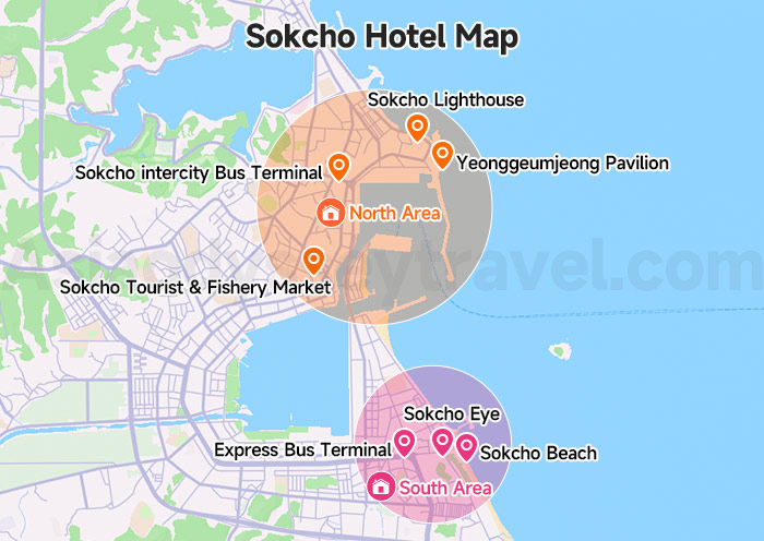
When planning a trip to Sokcho, most hotels are concentrated in three main areas. The Sokcho Hotel Map helps you quickly understand which area fits your travel style and how each location connects to beaches, markets, and Seoraksan National Park.
| South Area (Beach & Express Bus Terminal) | North Area (Central Market & Intercity Bus Terminal) | |
|---|---|---|
| Location | Near Sokcho Beach | Near Sokcho Central Market |
| Atmosphere | Modern, coastal, lively | Local, traditional, budget-friendly |
| Best For | First-time visitors, ocean stays | Food lovers, budget travelers |
| Key Spots | Sokcho Beach, Sokcho Eye, Express Bus Terminal | Sokcho Tourist & Fishery Market, Yeonggeumjeong Pavilion, Sokcho Lighthouse, Sokcho Intercity Bus Terminal |
- Sokcho is a small city, so taxi rides between hotel areas are usually short and affordable.
- Bus 7 / 7-1 can connect all major hotel zones with Seoraksan National Park.
- For first-time visitors, staying near the Express Bus Terminal or Sokcho Beach is the most convenient choice.
9 Days Eastern Korea Tour from Seoul to Busan: Modern City, Coasts, Silla Culture
Seoul - Suwon - Sokcho - Andong - Gyeongju - Busan
Sokcho Transportation Map - How to Get to Sokcho
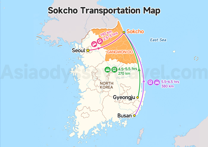
Although most travelers visit Sokcho from Seoul, the city is also connected with other popular destinations along South Korea's eastern side, including Busan and Gyeongju.
The transportation map mainly shows the distance and travel routes between Sokcho and Korea's popular destinations.
| Route | Distance | Main Transportation | Travel Time | Notes |
|---|---|---|---|---|
| Seoul → Sokcho | ~190 km | Express Bus / Car | 2.5–3 hrs | Most popular route for international travelers |
| Busan → Sokcho | ~380 km | Intercity Bus / Drive | 5.5–6.5 hrs | Popular east coast travel route |
| Gyeongju → Sokcho | ~270 km | Bus + Transfer / Drive | 4.5–5.5 hrs | Often combined with east coast itineraries |
- Buses are the most common and convenient option for most travelers.
- Sokcho has no KTX train station, so rail travel does not directly connect the two cities.
Travel to Sokcho & South Korea with Asia Odyssey Travel
Sokcho looks close to Seoul on a map, but planning a smooth trip is often harder than expected.
Unlike Seoul or Busan, Sokcho is not connected by KTX high-speed rail. Once there, attractions are spread between the coastline and Seoraksan National Park.
While Google Maps only show public bus routes, it doesn't tell you the most efficient way to connect beaches, markets, mountain trails, viewpoints, and hotels into a practical itinerary.
Asia Odyssey Travel are right here to help you solve these questions:
- Should I stay near Sokcho Beach or Seoraksan?
- Can Seoraksan and the coastal attractions be visited on the same day?
- How much time is needed in Sokcho?
- What's the fastest and most comfortable way to get around?
Our local team knows Sokcho inside and out.
We help you plan the most efficient routes, arrange transportation, recommend the right hotels, and connect Sokcho seamlessly with destinations like Seoul, Gangneung, Busan, and beyond.
Whether you're visiting for a day trip, a weekend getaway, or a longer South Korea journey, we'll make sure your time is spent exploring—not figuring out logistics.
")

")
")


: City, Tourist, Subway, Train Map | 2026")
 Maps: Yongpyong Ski Resort Map")

")