Gyeonggi-do Location Map: Where is Gyeonggi-do in South Korea?
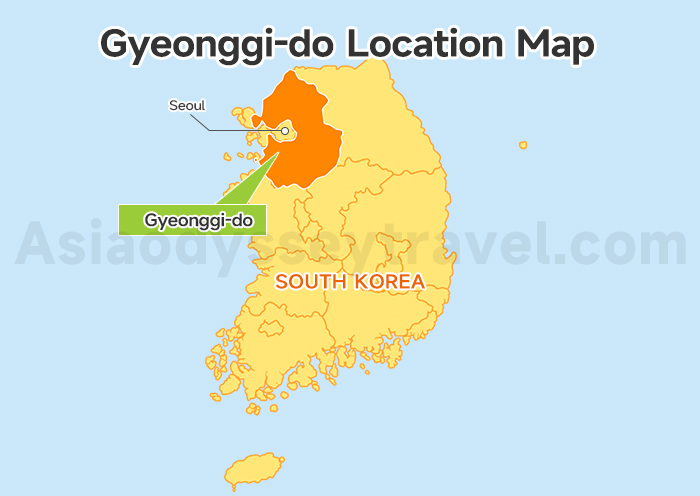
Gyeonggi Province is located in the northwestern part of South Korea.
Geographically, it forms a wide region around the capital area, with a very clear natural structure:
- To the north, it reaches the border area near the Korean Demilitarized Zone (DMZ).
- To the west, it faces the Yellow Sea coastline.
- To the east, the land gradually rises into mountain and hill regions.
- To the south, it opens into broad plains connecting toward central and southern Korea.
The Han River system flows through the region from southeast to northwest, shaping both the landscape and settlement patterns.
This mix of river valleys, mountains, plains, and coastal areas makes Gyeonggi-do one of the most geographically diverse and economically developed regions in Korea.
In simple terms, it's a region defined by contrast — borders, nature, and plains all meeting around the capital area of Seoul.
Gyeonggi-do Map with Cities: Where to Go for a Day Trip from Seoul
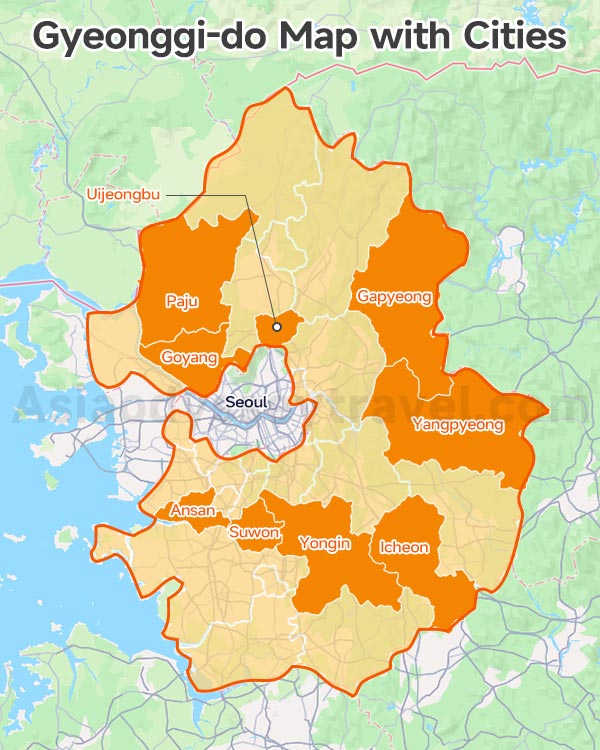
Unlike many provinces in Korea that focus on only one travel style, Gyeonggi-do contains a surprisingly wide variety of tourist cities around Seoul.
Some cities are famous for Korean history and UNESCO sites, while others attract visitors with theme parks, mountains, seaside scenery, shopping districts, or peaceful countryside experiences.
The tourist map below helps travelers quickly understand which cities are most worth visiting and what each area is best known for.
| Tourist City | Distance from Seoul | Main Attractions | Best For |
|---|---|---|---|
| Suwon | 35 km | Hwaseong Fortress, palace walls, markets | History & culture |
| Yongin | 40 km | Everland, Korean Folk Village | Families & theme parks |
| Paju | 35–50 km | DMZ, Provence Village, art spaces | History & unique experiences |
| Gapyeong | 60 km | Nami Island, rail bikes, rivers | Nature & couples |
| Yangpyeong | 50 km | Mountain cafés, rivers, healing trips | Relaxation & scenery |
| Goyang | 25 km | Ilsan Lake Park, KINTEX, modern districts | Easy suburban trips |
| Icheon | 70 km | Ceramics villages, hot springs | Local culture |
| Ansan | 35 km | Daebudo Island, coastal drives | West coast scenery |
| Uijeongbu | 25 km | Mountains, local food streets | Hiking & local life |
You don't need to visit all of them.
The easiest way to plan Gyeonggi-do is simply choosing the experience you want most — history, nature, family fun, seaside scenery, or countryside relaxation — and then picking the city that matches it best.
8 Days Western Korea Tour from Seoul to Jeju Island: Capital, Baekje Culture, Volcanic Island
Seoul - DMZ - Gongju - Jeonju - Jeju Island
Gyeonggi-do Tourist Map: What to See & Top Attractions
Gyeonggi-do is huge and incredibly diverse.
Some areas are famous for history and traditional culture, while others are known for mountains, theme parks, seaside scenery, shopping, or peaceful countryside escapes.
To make trip planning easier, this tourist map divides Gyeonggi-do into several practical day trip clusters around Seoul rather than administrative regions.
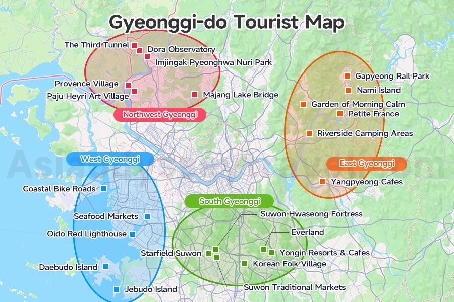
From the map, you can clearly see that most popular attractions naturally form several travel zones.
- Northwest Gyeonggi → DMZ, Korean War history, observatories, art villages
- East Gyeonggi → rivers, forests, rail bikes, cafés, healing countryside trips
- South Gyeonggi → Suwon, Everland, folk culture, family attractions
- West Gyeonggi → islands, tidal flats, seafood markets, coastal scenery
A common mistake is randomly selecting attractions from opposite sides of the province.
While everything may look "near Seoul" on the map, crossing the Seoul metropolitan area can easily waste several hours in transportation.
By following the travel zones below, you can plan smoother and much more efficient Seoul day trips.
Northwest Gyeonggi-do Map: DMZ History & Border Tourism
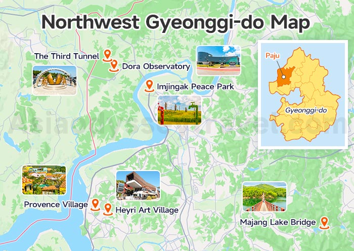
If you're interested in Korean history, Cold War stories, or places that feel completely different from modern Seoul, I'd strongly recommend heading northwest toward Paju and the DMZ region.
Here are the main attractions I'd recommend in Northwest Gyeonggi-do:
| Attraction | Why Visit |
|---|---|
| The Third Tunnel | A real infiltration tunnel near the border |
| Dora Observatory | View toward North Korea |
| Imjingak Peace Park | Important Korean War history site |
| Heyri Art Village | Artsy cafés, galleries, photo spots |
| Provence Village | Colorful European-style streets |
| Majang Lake Bridge | Scenic suspension bridge and walking trails |
DMZ official sightseeing needs advance reservation via authorized travel agency
East Gyeonggi-do Map: Rivers, Forests & Countryside Scenery
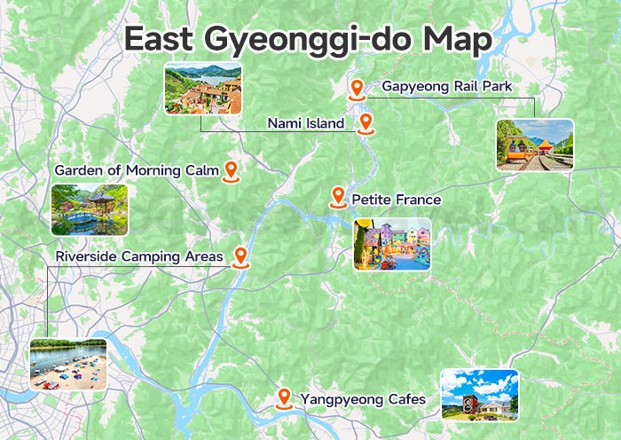
Eastern Gyeonggi-do is where many Seoul residents escape for nature, fresh air, and slower weekend trips.
As the landscape becomes greener and more mountainous, the atmosphere changes dramatically from the dense urban scenery of Seoul.
This region is especially famous for:
| Attraction | Why Visit |
|---|---|
| Nami Island | Korea's most famous romantic island |
| Garden of Morning Calm | Beautiful seasonal flower gardens |
| Gapyeong Rail Bike | Scenic riverside cycling experience |
| Yangpyeong Cafes | Relaxing mountain and river views |
| Petite France | Colorful French-style village |
| Riverside Camping Areas | Popular local weekend escape spots |
The eastern region is extremely popular among couples, families, and travelers looking for scenic photography spots.
One major advantage is the ITX train connection from Seoul, which makes places like Gapyeong surprisingly easy to reach despite the mountain scenery.
South Gyeonggi-do Map: Historical Cities & Theme Parks
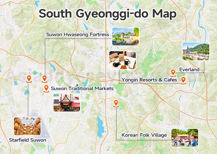
If it's your first time visiting Korea, I honestly think southern Gyeonggi-do is one of the safest and easiest day trip regions to start with.
Transportation is simple, subway access is excellent, and attractions are very traveler-friendly.
You can combine Korean history, shopping, cafés, and theme parks all in the same trip.
The biggest highlights here are Suwon and Yongin.
Here are the attractions I'd recommend most in South Gyeonggi-do:
| Attraction | Why Visit |
|---|---|
| Suwon Hwaseong Fortress | Korea's most famous fortress city wall |
| Everland | Korea's largest theme park |
| Korean Folk Village | Traditional Korean houses and performances |
| Starfield Suwon | Huge shopping and lifestyle complex |
| Suwon Traditional Markets | Great local food experience |
| Yongin Resorts & Cafes | Relaxing suburban atmosphere |
What I personally like about this region is the balance. It feels much less hectic than Seoul, but still very modern and convenient.
West Gyeonggi-do Map: Islands & Seafood Destinations
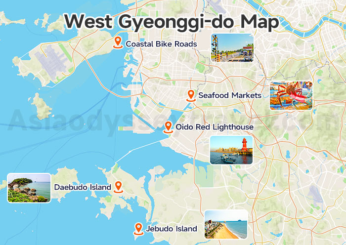
If you're craving ocean views, seafood, and slower coastal scenery, heading west toward the Yellow Sea coast.
Popular destinations include Daebudo Island, Oido, and several smaller coastal areas connected by bridges and ferries.
Here are some of the best west coast attractions:
| Attraction | Why Visit |
|---|---|
| Daebudo Island | Coastal drives and seafood restaurants |
| Oido Red Lighthouse | Famous seaside photo spot |
| Jebudo Island | Unique tidal road experience |
| West Coast Cafés | Ocean-view café hopping |
| Seafood Markets | Fresh shellfish and grilled seafood |
| Coastal Bike Roads | Relaxing seaside cycling routes |
Compared with eastern Gyeonggi's forest scenery, western Gyeonggi feels wider, windier, and more open.
Seoul to Gyeonggi-do Map: Distance & Transportation
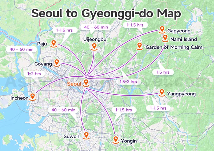
One reason Gyeonggi-do is so popular for day trips is simple: it begins almost immediately outside Seoul.
Unlike traveling to Busan or Jeju Island, you usually do not need flights or long-distance trains.
In many cases, you can leave central Seoul in the morning and arrive at a Gyeonggi-do destination within 30 minutes to 2 hours.
The table below gives a quick overview of some of the most popular Gyeonggi-do day trip destinations from Seoul.
| Destination | Approx. Distance | Typical Travel Time | Best Transportation |
|---|---|---|---|
| Suwon | 35 km | 40–60 min | Subway / KTX |
| Yongin (Everland) | 40 km | 1–1.5 hrs | Bus / Private Transfer |
| Paju (DMZ Area) | 35–50 km | 1–1.5 hrs | Bus / Tour |
| Gapyeong | 60 km | 1–1.5 hrs | ITX Train |
| Nami Island Area | 63 km | 1.5 hrs | ITX + Ferry |
| Garden of Morning Calm | 70 km | 1.5–2 hrs | Train + Bus |
| Goyang | 25 km | 40–60 min | Subway |
| Incheon Coast & Islands | 40–70 km | 1–2 hrs | Subway / Ferry |
| Yangpyeong | 50 km | 1–1.5 hrs | Subway / Train |
| Uijeongbu | 25 km | 40–60 min | Subway |
- Western and southern Gyeonggi areas are usually the closest to Seoul.
- Eastern mountain regions often take longer because of terrain and fewer rail lines.
- Northern border areas near the DMZ may look close on the map but require extra travel time due to limited transportation routes.
Gyeonggi-do Travel Map: Suggested Gyeonggi-do Day Trip Routes
Route 1: Historic UNESCO Heritage Day (Suwon + Yongin | Culture & Joseon Dynasty)
Theme: World Heritage Fortress + Traditional Korean Folk Culture
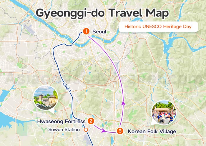
Daily Schedule
08:30 Depart Seoul → Suwon by Line 1 Subway (45min)
09:20–12:00 Hwaseong Fortress (UNESCO World Heritage)
Core spots: Paldalmun Gate, Haenggung Palace, fortress wall hiking, royal guard changing ceremony
Local lunch: Suwon Galbi (spicy pork ribs) at Nammun Traditional Market
13:30–17:00 Korean Folk Village (Yongin)
Watch folk dances, tightrope shows, rent Hanbok, explore Joseon-era village architecture
18:00 Return to Seoul by direct shuttle bus
9 Days Eastern Korea Tour from Seoul to Busan: Modern City, Coasts, Silla Culture
Seoul - Suwon - Sokcho - Andong - Gyeongju - Busan
Route 2: K-Drama Nature Day (Gapyeong-gun | Lakes & Fairy-Tale Towns)
Theme: Classic Korean drama filming sites, forest & lake scenery
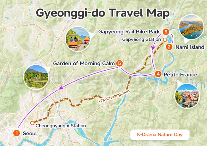
Daily Schedule
08:20 Take ITX-Cheongchun from Cheongnyangni Station to Gapyeong (50min)
09:30–11:30 Nami Island (Winter Sonata filming spot) | lakeside cedar trail, island ferry tour
12:00–13:30 Lunch near Gapyeong Rail Bike Park
14:00–15:30 Petite France (Little French Village, My Love from the Star) | colorful European cottages
16:00–17:30 Garden of Morning Calm | seasonal flower garden, woodland walk
18:30 Take ITX back to Seoul
Route 3: DMZ Peace & Border Day (Paju | History & Border Sightseeing)
Theme: Korean modern history, DMZ non-military zone sightseeing (pre-booking required)
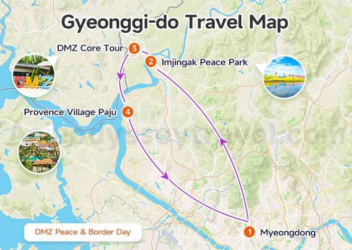
Daily Schedule
08:00 Join organized DMZ tour departing Myeongdong
09:30–11:00 Imjingak Peace Park + Freedom Bridge (Korean War relic exhibition)
11:30–14:00 DMZ Core Tour: Third Infiltration Tunnel + Dora Observatory (overlook North Korea view)
14:30–16:30 Provence Village Paju | European flower-themed small town, photo spot
17:30 Return Seoul
Note: DMZ official sightseeing needs advance reservation via authorized travel agency
10 Days South Korea Panoramic Tour: History, Culture, Nature & Cityscape
Seoul - DMZ - Andong - Gyeongju - Busan - Jeju Island
Travel Around Seoul & Korea with Asia Odyssey Travel
Planning day trips around Seoul can look easy on the map — but once you actually start combining DMZ tours, train schedules, subway transfers, and regional attractions, the logistics can quickly become confusing.
That's where Asia Odyssey Travel can help.
Asia Odyssey Travel provides customized Seoul metropolitan + Gyeonggi-do outbound day-trip packages, covering
- fixed scheduled group tours
- tailor-made private itineraries
- local transit guidance
- exclusive private car charter
- multi-city Korea tours beyond Seoul
for individual, family and small-group travelers across South Korea.
With local support, experienced drivers, and customized planning, it becomes much easier to explore beyond central Seoul and discover the more diverse side of Korea.
")

")
")


: City, Tourist, Subway, Train Map | 2026")
 Maps: Yongpyong Ski Resort Map")

")